Liesveld (former municipality)
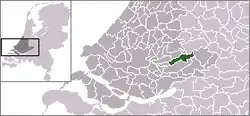
Liesveld (Dutch pronunciation: [ˈlisfɛlt] (![]() listen)) is a former municipality in the western Netherlands, in the province of South Holland, and the region of Alblasserwaard. The former municipality had a population of 9,810 in 2006, and covered an area of 44.44 km² (17.16 mile²) of which 3.37 km² (1.30 mile²) was water. Since 2013 Liesveld had been a part of the new municipality of Molenwaard (ceased to exist in 2019).
listen)) is a former municipality in the western Netherlands, in the province of South Holland, and the region of Alblasserwaard. The former municipality had a population of 9,810 in 2006, and covered an area of 44.44 km² (17.16 mile²) of which 3.37 km² (1.30 mile²) was water. Since 2013 Liesveld had been a part of the new municipality of Molenwaard (ceased to exist in 2019).
Liesveld | |
|---|---|
Former municipality | |
 Flag  Coat of arms | |
 | |
| Coordinates: 51°55′00″N 4°49′30″E | |
| Country | Netherlands |
| Province | South Holland |
| Municipality | Molenlanden |
| Area (2006) | |
| • Total | 44.44 km2 (17.16 sq mi) |
| • Land | 41.07 km2 (15.86 sq mi) |
| • Water | 3.37 km2 (1.30 sq mi) |
| Population (1 January 2007) | |
| • Total | 9,802 |
| • Density | 239/km2 (620/sq mi) |
| Source: CBS, Statline. | |
| Time zone | UTC+1 (CET) |
| • Summer (DST) | UTC+2 (CEST) |
The former municipality of Liesveld was formed on 1 January 1986 from the former municipalities of Groot-Ammers, Langerak, Nieuwpoort, and Streefkerk. It consisted of the population centres Groot-Ammers, Langerak, Nieuwpoort, Streefkerk, and Waal.
Its name is probably derived from a low-lying swampy area filled with reed grasses (Dutch: lies - Glyceria maxima) near Gelkenes. Castle Liesvelt was built on such a reedy field, giving its name to the Lords of Liesvelt, who owned lands within the municipality.