List of crossings of the River Soar
This is a list of crossings of the River Soar, the principal river of Leicestershire in the Midlands of England. Listed in the table are those crossings that have been identified downstream of the Soar Brook confluence, near Sharnford, to the last crossing near Ratcliffe-on-Soar upstream of Soar Mouth where the river meets the Trent.[1][2]
.jpg.webp)
At Aylestone in Leicester the Grand Union Canal meets the Soar, to form the Soar Navigation. Downstream from this point the navigation and river become intertwined with weirs and bypass channels, one prominent section is the Mile Straight constructed for flood alleviation in the 1890s. It has four listed crossings along its length, including Upperton Road, Mill Lane, Newarke, and West Bridge. The current West Bridge built in 1891, replaced an earlier stone bridge with four arches, that once had a bridge chapel.[3] Crossing the Old Soar nearby, is Bow Bridge, although rebuilt in 1863, the earlier medieval bridge was strongly associated with the local folklore surrounding the death of Richard III.[4]
Other notable crossings include the scheduled packhorse bridges at Aylestone and Enderby Mill, with the bridges at Cossington, Barrow, Cotes and Kegworth all being Grade II listed. Near Mountsorrel, a listed red brick bridge from 1860 has been described as “an impressive local landmark.”[5]
Crossings
| Status | Criteria[6] |
|---|---|
| I | Grade I listed. Bridge of exceptional interest, sometimes considered to be internationally important |
| II* | Grade II* listed. Particularly important bridge of more than special interest |
| II | Grade II listed. Bridge of national importance and special interest |
| Scheduled Monument. Nationally important archaeological bridge. |
| River order | Name | Image | From /To Coordinates |
Carries | Date | Heritage status |
Notes & refs |
|---|---|---|---|---|---|---|---|
| 1 | Footbridge | .jpg.webp) | Sharnford 52.52412°N 1.28196°W | Footpath | Footbridge downstream of Soar Brook confluence.[7] | ||
| 2 | Road Bridge | 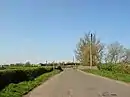 | Sapcote 52.52461°N 1.28064°W | Main Street | Road to Frolesworth.[7] | ||
| 3 | Stoney Bridge | .jpg.webp) | Sapcote 52.53219°N 1.25908°W | Fosse Way | First named bridge.[7] | ||
| 4 | Road Bridge | 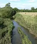 | Broughton Astley 52.54030°N 1.24810°W | B581 | Coventry Road.[7] | ||
| 5 | Sutton Hill Bridge | Broughton Astley 52.54199°N 1.24790°W | B4114 | Coventry Road.[7] | |||
| 6 | Sopers Bridge & Footbridge |  | Croft 52.54778°N 1.25741°W | Footpath | II | Sopers Bridge is located on an old course of the river.[7][8] | |
| 7 | Railway bridge | Croft 52.55671°N 1.25097°W | Birmingham to Peterborough Line | Stoney Stanton to Croft.[7] | |||
| 8 | Croft Bridge | 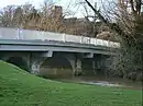 | Croft 52.55864°N 1.24698°W | Station Road | Modern road bridge.[7] | ||
| 9 | Footbridge | 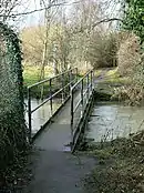 | Croft 52.55835°N 1.24202°W | Footpath | Near Croft Quarry.[7] | ||
| 10 | Langham Bridge | .jpg.webp) | Narborough 52.56825°N 1.21669°W | Coventry Road | Historic bridging point of Fosse Way.[9] | ||
| 11 | Railway bridge | Narborough 52.56800°N 1.21168°W | Birmingham to Peterborough Line | Upstream from Narborough station.[9] | |||
| 12 | Station Road Bridge | .jpg.webp) | Littlethorpe 52.57081°N 1.20342°W | Station Road | Near Narborough Station.[10] | ||
| 13 | M1 Bridge |  | Narborough 52.57136°N 1.19342°W | M1 Motorway | Motorway bridge.[10] | ||
| 14 | Railway bridge | Enderby 52.57592°N 1.18856°W | Birmingham to Peterborough Line | Downstream of M1.[10] | |||
| 15 | Enderby Mill Bridge | .jpg.webp) | Enderby 52.58069°N 1.18962°W | Footpath | 15th century | SM | Scheduled bridge with adjacent footbridge.[10][11] |
| 16 | Enderby Bridge | .jpg.webp) | Enderby 52.58145°N 1.18858°W | Enderby Rd | Modern road bridge.[10] | ||
| 17 | Soar Valley Way |  | Enderby 52.59594°N 1.17007°W | A563 | Dual carriageway.[12] | ||
| 18 | Aylestone Packhorse Bridge | 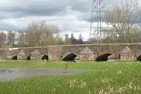 | Aylestone 52.60326°N 1.16288°W | Footpath | 15th century | II & SM | Scheduled packhorse bridge.[12][13] |
| 19 | Footbridge | .jpg.webp) | Aylestone 52.60338°N 1.16229°W | Towpath | Crosses Soar where it joins with canal.[12] | ||
| 20 | Footbridge | 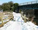 | Aylestone 52.60383°N 1.16117°W | Grand Central Way | Former Great Central Railway.[12] | ||
| 21 | Freestone Bridge |  | Aylestone 52.60466°N 1.15944°W | Braunstone Lane East | Braunstone Lane East.[12] | ||
| 22 | Parsons Bridge | 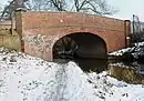 | Aylestone 52.60698°N 1.15359°W | Canal Street | Access road to Aylestone Meadows.[12] | ||
| 23 | Aylestone Mill | .jpg.webp) | Aylestone 52.60995°N 1.14646°W | Aylestone Mill | Access road to Aylestone Meadows.[12] | ||
| 24 | Access bridge | .jpg.webp) | Aylestone 52.61101°N 1.14346°W | Access road | Access road to industrial estate.[14] | ||
| 25 | Twelve Arches railway viaduct |  | Westcotes 52.61987°N 1.14656°W | Leicester–Burton upon Trent line | Upstream of Freemans Weir.[15] | ||
| 26 | Footbridge across Old Soar | .jpg.webp) | Bede Island 52.62435°N 1.14354°W | Towpath | Old River Soar - first crossing.[16] | ||
| 27 | Watkin Road Bridge | .jpg.webp) | Bede Island 52.62534°N 1.14485°W | Access road | Old River Soar.[15] | ||
| 28 | Upperton Road Bridge | .jpg.webp) | Bede Island 52.62572°N 1.14532°W | Upperton Road | Old River Soar.[15] | ||
| 29 | Great Central Way footbridge | .jpg.webp) | Bede Island 52.62661°N 1.14641°W | Great Central Way | Former railway bridge over the Old River Soar - a disused bridge is adjacent.[15] | ||
| 30 | Footbridge | Bede Island 52.62816°N 1.14639°W | Footpath | Old Soar - Modern Footbridge.[15] | |||
| 31 | Western Boulevard | .jpg.webp) | Bede Island 52.63194°N 1.14426°W | Road | Old Soar, site of demolished Braunstone Gate Bridge.[15] | ||
| 32 | Bow Bridge | .jpg.webp) | Bede Island 52.63397°N 1.14425°W | A47 | 1863 | Old Soar-St Augustine Road bridge.[15] | |
| 33 | Upperton Road Bridge | .jpg.webp) | Mile Straight 52.62562°N 1.14310°W | Upperton Road | 1890 | II | One of four listed bridges on the Mile Straight.[16][17] |
| 34 | Swan Bridge | .jpg.webp) | Mile Straight 52.62604°N 1.14302°W | Upperton Road | 109A Eastbound Modern bridge.[16] | ||
| 35 | Mill Lane bridge | .jpg.webp) | Mile Straight 52.62875°N 1.14260°W | Mill Lane | 1890 | II | One of four listed bridges on the Mile Straight.[16][18] |
| 36 | Newarke Bridge | .jpg.webp) | Mile Straight 52.63110°N 1.14226°W | The Newarke | 1898 | II | One of four listed bridges on the Mile Straight.[16][19] |
| 37 | Footbridge | .jpg.webp) | Mile Straight 52.63262°N 1.14205°W | Footpath | Bridge 2A.[16] | ||
| 38 | West Bridge | .jpg.webp) | Mile Straight 52.63362°N 1.14219°W | A47 | 1891 | II | Historic bridging point, one of four listed bridges on the Mile Straight.[16][20] |
| 39 | West Bridge | .jpg.webp) | Mile Straight 52.63380°N 1.14239°W | A47 | Eastbound Modern.[16] | ||
| 40 | Footbridge | 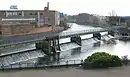 | Westcotes 52.63761°N 1.14498°W | Footpath | Evans Weir.[15] | ||
| 41 | Soar Lane bridge | .jpg.webp) | Westcotes 52.63821°N 1.14546°W | Soar Lane | West side of Soar island.[15] | ||
| 42 | Footbridge | 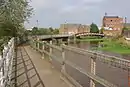 | Soar Island 52.63979°N 1.14566°W | Towpath | Between Soar and Frog Island.[21] | ||
| 43 | North Bridge | .jpg.webp) | Frog Island 52.64293°N 1.14414°W | A50 | Links Woodgate to Frog Island.[22] | ||
| 44 | St Margarets Way | .jpg.webp) | Frog Island 52.64421°N 1.14053°W | A6 | Dual bridges.[22] | ||
| 45 | Footbridge | .jpg.webp) | Abbey Park 52.64456°N 1.13973°W | Footpath | Concrete footbridge.[22] | ||
| 46 | Abbey Park Bridge | .jpg.webp) | Abbey Park 52.64688°N 1.13685°W | Footpath | Ornamental footbridge.[22] | ||
| 47 | Abbey Corner Bridge |  | Abbey Park 52.64904°N 1.13423°W | Abbey Park Road | 1878 | II | Abbey Park Road Bridge.[22][23] |
| 48 | Abbey Meadows footbridge | _(geograph_3757586).jpg.webp) | Abbey Meadows 52.65265°N 1.13237°W | Footpath | 2013 | Wolsey Point to National Space Centre | |
| 49 | Holden Street footbridge | .jpg.webp) | Belgrave 52.65551°N 1.12563°W | Footpath | 1985 | Refurbished in 2015.[22] | |
| 50 | Belgrave Bridge |  | Belgrave 52.66082°N 1.12833°W | Thurcaston Road | Probable 15th century | II | Thurcaston Road Bridge (Old Bridge).[22][24] |
| 51 | New Bridge | 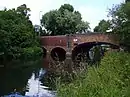 | Belgrave 52.66297°N 1.12685°W | Loughborough Road | 1834 | II | Loughborough Road Bridge.[22][25] |
| 52 | Watermead Bridge |  | Rushey Mead 52.66664°N 1.11827°W | Watermead Way | A563.[22] | ||
| 53 | Birstall weir footbridge | .jpg.webp) | Rushey Mead 52.67210°N 1.11430°W | Towpath | Curved weir and footbridge.[26] | ||
| 54 | Footbridge | Birstall 52.67265°N 1.11380°W | Footpath | Near Birstall Lock.[26] | |||
| 55 | Birstall Lock footbridge | .jpg.webp) | Birstall 52.67378°N 1.11620°W | Footpath | One of a number of bridges at Birstall Lock.[26] | ||
| 56 | Birstall Lock footbridge | .jpg.webp) | Birstall 52.67381°N 1.11596°W | Footpath | Bridge 14c.[26] | ||
| 57 | Footbridge | .jpg.webp) | Birstall 52.67459°N 1.11690°W | Towpath | White Horse Lane.[27] | ||
| 58 | Footbridge | .jpg.webp) | Watermead Country Park 52.67865°N 1.10240°W | Towpath | Bridge 16B, Thurmaston Weir.[27] | ||
| 59 | Footbridge | .jpg.webp) | Watermead Country Park 52.67968°N 1.10195°W | Towpath | Downstream of Thurmaston Lock.[27] | ||
| 60 | Footbridge | .jpg.webp) | Watermead Country Park 52.68362°N 1.10116°W | Towpath | Crosses Soar where it splits with canal.[27] | ||
| 61 | Footbridge | 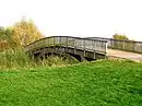 | Watermead Country Park 52.68564°N 1.10588°W | Footpath | King Lears Lake.[27] | ||
| 62 | Pochin Bridge |  | Wanlip 52.69668°N 1.10837°W | A46 | Leicester Western Bypass.[28] | ||
| 63 | Cossington footbridge | .jpg.webp) | Cossington 52.70954°N 1.12005°W | Towpath | Above Cossington Lock.[2] | ||
| 64 | Cossington Bridge | 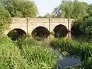 | Cossington 52.71130°N 1.12090°W | Cossington Lane | c. 1800 | II | Listed bridge.[29] |
| 65 | Sileby Lock footbridges | .jpg.webp) | Sileby 52.72724°N 1.12400°W | Towpath | Series of three footbridges.[2] | ||
| 66 | Sileby Mill footbridge | 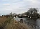 | Sileby 52.72832°N 1.12547°W | Towpath | Sileby Mill.[2] | ||
| 67 | A6 bridge | .jpg.webp) | Mountsorrel 52.73220°N 1.13450°W | A6 | One of four A6 crossings.[2] | ||
| 68 | Sileby Lane bridge | .jpg.webp) | Mountsorrel 52.73119°N 1.14021°W | Sileby Lane | East of Mountsorrel.[2] | ||
| 69 | Mountsorrel mineral railway bridge | .jpg.webp) | Mountsorrel 52.73294°N 1.14292°W | Conveyor | 1860 | II | 1860 bridge - Brick bridge.[5] |
| 70 | Mountsorrel turnover Bridge 26 |  | Mountsorrel 52.73541°N 1.14451°W | Towpath | Carries towpath from one bank to the other.[2] | ||
| 71 | A6 bridge |  | Mountsorrel 52.73934°N 1.14263°W | A6 | One of four A6 crossings.[2] | ||
| 72 | Footbridge | .jpg.webp) | Barrow upon Soar 52.74573°N 1.14457°W | Towpath | Crosses over weir.[2] | ||
| 73 | Footbridge | Barrow upon Soar 52.74367°N 1.14652°W | Footpath | Between Barrow and A6.[2] | |||
| 74 | A6 bridge | .jpg.webp) | Barrow upon Soar 52.74240°N 1.14790°W | A6 | One of four A6 crossings.[2] | ||
| 75 | A6 bridge | | Quorn 52.74830°N 1.15861°W | A6 | One of four A6 crossings.[2] | ||
| 76 | Mill Lane bridge | 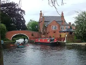 | Barrow upon Soar 52.74590°N 1.14733°W | Mill Lane | Navigation Inn.[2] | ||
| 77 | Barrow Lock bdg |  | Barrow upon Soar 52.74981°N 1.15265°W | Proctors Park Road | Minor road.[2] | ||
| 78 | Barrow Road Bridge |  | Barrow upon Soar 52.75081°N 1.15303°W | Bridge Street | 1845 | II | Listed bridge.[30] |
| 79 | Pillings Lock rail bdg |  | Barrow upon Soar 52.75970°N 1.16350°W | Midland Main Line | Railway bridge.[2] | ||
| 80 | Cotes Bridge | 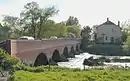 | Cotes 52.78026°N 1.18025°W | A60 | 18th century | II | Nottingham Road.[31] |
| 81 | Footbridge |  | Cotes 52.78939°N 1.19466°W | Footpath | One of two footbridges at this point.[2] | ||
| 82 | Footbridge |  | Cotes 52.78857°N 1.19518°W | Footpath | One of two footbridges at this point.[2] | ||
| 83 | Stanford Viaduct | 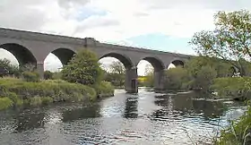 | Stanford on Soar 52.79030°N 1.19740°W | Great Central Railway (heritage railway) | 1899 | Skewed central arches.[2] | |
| 84 | Meadow Lane Bridge | .jpg.webp) | Stanford on Soar 52.79063°N 1.19849°W | Meadow Lane | Minor road.[2] | ||
| 85 | Railway bridge | .jpg.webp) | Stanford on Soar 52.79370°N 1.21650°W | Midland Main Line | Major rail bridge.[2] | ||
| 86 | Zouch footbridges | 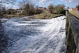 | Zouch 52.80618°N 1.24575°W | Footpath | A series of three footbridges over the weirs at Zouch.[2] | ||
| 87 | Zouch Bridge | .jpg.webp) | Zouch 52.80448°N 1.25606°W | A6006 | County Bridge, due for replacement.[2] | ||
| 88 | Kegworth Bridge | 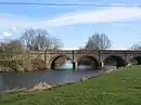 | Kegworth 52.84034°N 1.26906°W | Station Road | 1785 | II | Grade II bridge, widened in 1937.[32] |
| 89 | Kegworth footbridge | 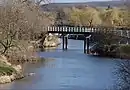 | Kegworth 52.84183°N 1.26706°W | Towpath | Carries towpath across the river.[2] | ||
| 90 | A453 Bridge |  | Ratcliffe-on-Soar 52.85784°N 1.26459°W | A453 | Remembrance Way.[2] | ||
| 91 | Ratcliffe on Soar Ford | .jpg.webp) | Ratcliffe-on-Soar 52.85903°N 1.26538°W | Bridleway | Ford across the Soar.[2] | ||
| 92 | Soar Mouth |  | Ratcliffe-on-Soar 52.87313°N 1.26829°W | Trent Lock ferry | In the 1900s a ferry crossed from the Soar to Trent Lock at the Trent confluence, carrying horses and passengers.[33][2] |
Bibliography
- Smith (1996). Leicester A-Z Street Atlas. Geographers A-Z Map Company Ltd. ISBN 9780850393408.
References
- A-Z 1996, pp. 6-51.
- 129 Nottingham and Loughborough (Map). 1:50,000. OS Landranger Map Series. Ordnance Survey. 2004. ISBN 9780319 22879 1.
- Jervoise, E. (1932). The Ancient Bridges of Mid and Eastern England. Read Books Limited. pp. 28–. ISBN 978-1-4733-4079-4.
- "Bow Bridge". Leicester City Council. Retrieved 10 February 2019.
- Historic England. "Mountsorrel mineral railway bridge (1287391)". National Heritage List for England. Retrieved 10 February 2019.
- Listed Buildings, English Heritage, archived from the original on 27 December 2012, retrieved 22 April 2011
- A-Z 1996, p. 51.
- Historic England. "Sopers Bridge (1074692)". National Heritage List for England. Retrieved 10 February 2019.
- A-Z 1996, p. 42.
- A-Z 1996, p. 43.
- Historic England. "Enderby Mill Bridge (1005083)". National Heritage List for England. Retrieved 10 February 2019.
- A-Z 1996, p. 35.
- Historic England. "Aylestone packhorse bridge (1074055)". National Heritage List for England. Retrieved 10 February 2019.
- A-Z 1996, p. 36.
- A-Z 1996, p. 27.
- A-Z 1996, p. 28.
- Historic England. "Upperton Road Bridge (1074785)". National Heritage List for England. Retrieved 10 February 2019.
- Historic England. "Mill Lane (1184807)". National Heritage List for England. Retrieved 10 February 2019.
- Historic England. "Newarke Bridge (1074794)". National Heritage List for England. Retrieved 10 February 2019.
- Historic England. "West Bridge (1074789)". National Heritage List for England. Retrieved 10 February 2019.
- A-Z 1996, p. 19.
- A-Z 1996, p. 20.
- Historic England. "Abbey Corner Bridge (1387174)". National Heritage List for England. Retrieved 10 February 2019.
- Historic England. "Belgrave Bridge (1299667)". National Heritage List for England. Retrieved 10 February 2019.
- Historic England. "NewBridge (1387173)". National Heritage List for England. Retrieved 10 February 2019.
- A-Z 1996, p. 13.
- A-Z 1996, p. 14.
- A-Z 1996, p. 6.
- Historic England. "Cossington Bridge (1287390)". National Heritage List for England. Retrieved 10 February 2019.
- Historic England. "Barrow Road Bridge (1074588)". National Heritage List for England. Retrieved 10 February 2019.
- Historic England. "Cotes Bridge (1074530)". National Heritage List for England. Retrieved 10 February 2019.
- Historic England. "Kegworth Bridge (1068673)". National Heritage List for England. Retrieved 10 February 2019.
-
- Taylor, Mike (2000). The River Trent Navigation. Tempus Publishing. p. 113. ISBN 0-7524-1743-6.
External links
| Wikimedia Commons has media related to Bridges across the River Soar. |