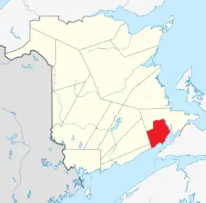
List of historic places in Albert County, New Brunswick
This article is a list of historic places in Albert County, New Brunswick entered on the Canadian Register of Historic Places, whether they are federal, provincial, or municipal.
List of historic places in albert county nb
| Name | Address | Coordinates | IDF | IDP | IDM | Image | |
|---|---|---|---|---|---|---|---|
| Acadien Battle Field | 2861 Main Street, Hillsborough, NB | 45°55′21″N 64°38′41″W | 18123 |  | |||
| Administration Building | 2861 Main Street, Fundy National Park, NB | 45°35′44″N 64°57′03″W | 10096 | | |||
| Albert Manufacturing Co. Office | 2849 Main Street, Hillsborough, NB | 45°55′23″N 64°38′43″W | 18370 | | |||
| Albert Mines Site | Old Albert Mines Road, Albert Mines, NB | 45°53′07″N 64°41′23″W | 9423 | | |||
| Coverdale United Church | 1174 Coverdale Road, Riverview, NB | 46°02′45″N 64°51′55″W | 5734 | | |||
| Willy Duffy House | 3 Duffy Lane, Hillsborough, NB | 45°55′36″N 64°38′56″W | 16405 | | |||
| Richard A. Gross House | 2834 Main Street, Hillsborough, NB | 45°55′29″N 64°38′50″W | 18371 | | |||
| Hillsborough Fashions | 2803 Main Street, Hillsborough, NB | 45°55′36″N 64°38′52″W | 18181 | | |||
| Hillsborough Pioneer Cemetery | 2807a Main Street, Hillsborough, NB | 45°55′33″N 64°38′50″W | 18167 | | |||
| Hillsborough United Church | 2891 Main Street, Hillsborough, NB | 45°55′10″N 64°38′37″W | 16524 | | |||
| Captain William Irving House | 2792 Main Street, Hillsborough, NB | 45°55′40″N 64°38′58″W | 16343 | | |||
| Dr. Jump House | 2826 Main Street, Hillsborough, NB | 45°55′31″N 64°38′55″W | 18164 | | |||
| Honourable John Lewis House | 2889 Main Street, Hillsborough, NB | 45°55′11″N 64°38′36″W | 17561 | | |||
| New Brunswick Railway Museum | 2847 Main Street, Hillsborough, NB | 45°55′23″N 64°38′45″W | 18394 | | |||
| Old Hillsborough Post Office | 2852 Main Street, Hillsborough, NB | 45°55′24″N 64°38′46″W | 16381 | | |||
| Peck Memorial Hall | 2820 Main Street, Hillsborough, NB | 45°55′33″N 64°38′52″W | 16501 | | |||
| Allison Peck House | 2832 Main Street, Hillsborough, NB | 45°55′29″N 64°38′50″W | 18369 | | |||
| John Peck House | 15 Pleasant Street, Hillsborough, NB | 45°55′30″N 64°38′54″W | 18166 | | |||
| Riverside Consolidated School | 90 Water Street, Riverside-Albert, NB | 45°44′53″N 64°43′53″W | 2207 |  More images | |||
| Rose Arbor | 2835 Main Street, Hillsborough, NB | 45°55′27″N 64°38′46″W | 16357 | | |||
| Saint Mary's Anglican Church | 39 Mill Street, Hillsborough, NB | 45°55′29″N 64°38′39″W | 16641 | 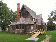 | |||
| Saltwater Pool and Bathhouse | 51 Point Wolfe Road, Alma, NB | 45°35′26″N 64°57′10″W | 13090 | | |||
| Steeves House | 40 Mill Street, Hillsborough, NB | 45°55′31″N 64°38′38″W | 13983 | 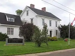 | |||
| Christian Steeves House | 45 Pleasant Street, Hillsborough, NB | 45°55′27″N 64°39′00″W | 16382 | | |||
| Jordan Steeves Business Block | 2848 Main Street, Hillsborough, NB | 45°55′25″N 64°38′47″W | 16354 | | |||
| Jordan Steeves House | 2838 Main Street, Hillsborough, NB | 45°55′28″N 64°38′48″W | 16345 | | |||
| Richard Steeves House | 2812 Main Street, Hillsborough, NB | 45°55′34″N 64°38′54″W | 18161 | | |||
| Taylor Estate | 23 Taylor Lane, Hillsborough, NB | 45°54′48″N 64°38′29″W | 16404 | | |||
| Valley Baptist Church | 3039 Main Street, Hillsborough, NB | 45°54′31″N 64°38′07″W | 16394 | | |||
| Victoria Manor | Maple Street, Riverside-Albert, NB | 45°45′10″N 64°43′32″W | 3205 | | |||
| Victoriana Steeves Homestead Bed and Breakfast | 57 Pleasant Street, Hillsborough, NB | 45°55′26″N 64°39′01″W | 16504 | | |||
| Wallace Farm | 2908 Main Street, Hillsborough, NB | 45°55′07″N 64°38′37″W | 16161 | | |||
| Wolastoq National Historic Site of Canada | Entire watershed of Saint John River, central and western New Brunswick, parts of southeastern Quebec, NB | 45°49′35″N 65°12′17″W | 18954 | 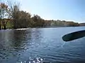 More images | |||
| Captain Wood House | 2819 Main Street, Hillsborough, NB | 45°55′31″N 64°38′49″W | 18372 | |
See also
| Wikimedia Commons has media related to Cultural heritage monuments in New Brunswick. |
This article is issued from Wikipedia. The text is licensed under Creative Commons - Attribution - Sharealike. Additional terms may apply for the media files.