List of historic places in Kingston, Ontario
This article is a list of historic places in the City of Kingston, Ontario entered on the Canadian Register of Historic Places, whether they are federal, provincial, or municipal.
See also List of historic places in Ontario.
List of historic places
| Name | Address | Coordinates | IDF | IDP | IDM | Image | |
|---|---|---|---|---|---|---|---|
| Branch Tower East | Fort Henry Defence Complex, Kingston, ON | 44°14′N 76°28′W | 4357 |  More images | |||
| Defensible Lockmaster's House | Rideau Canal National Historic Site of Canada, Kingston, ON | 44°14′52″N 76°11′17″W | 16781 |  | |||
| Defensible Lockmaster's House | Rideau Canal National Historic Site of Canada, Kingston, ON | 44°33′48″N 76°17′29″W | 16782 |  | |||
| Kingston Harbour, Shoal Martello Tower | In Kingston Harbour, Kingston, ON | 44°13′44″N 76°28′41″W | 4737 |  More images | |||
| Lower Brewers Defensible Lockmaster's House | Rideau Canal National Historic Site of Canada, Kingston (Washburn), ON | 44°23′20″N 76°19′30″W | 11024 |  | |||
| Vimy Barracks Building B7 | 1 Estafette Street, Vimy Barracks, CFB Kingston, ON | 44°14′24″N 76°26′13″W | 2883 | | |||
| 1 Baiden Street | 1 Baiden Street, Kingston, ON | 44°13′18″N 76°31′09″W | 9664 | ||||
| 157-161 Queen Street | 157 Queen Street, Kingston, ON | 44°13′59″N 76°29′08″W | 9734 | 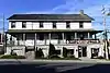 | |||
| 223 King Street East, Kingston | 223 King Street East, Kingston, ON | 44°13′39″N 76°29′01″W | 8265 |  More images | |||
| 232 King Street East | 232 King Street East, Kingston, ON | 44°13′40″N 76°29′00″W | 15961 | 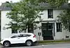 More images | |||
| 610 Montreal Street | 610 Montreal Street, Kingston, ON | 44°14′54″N 76°29′12″W | 14101 | | |||
| 9 North Street | 9 North Street, Kingston, ON | 44°14′15″N 76°28′53″W | 15958 | | |||
| Administration Building /Cell Block (C-18, C-16) | Former Women's Prison, Kingston, ON | 44°13′43″N 76°33′21″W | 7584 |  | |||
| Anglican Diocesan Centre | 90 Johnson Street, Kingston, ON | 44°13′46″N 76°29′02″W | 10768 |  More images | |||
| Ann Baillie Building National Historic Site of Canada | Kingston General Hospital Complex, Kingston, ON | 44°13′26″N 76°29′30″W | 4024 | 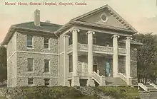 More images | |||
| Armoury | 100 Montreal Street, Kingston, ON | 44°14′02″N 76°29′02″W | 3308 | | |||
| Barriefield Heritage Conservation District | On a hillside rising from the eastern shore of the Great Cataraqui River, adjacent to the intersection of Highways 2 and 15 near Fort Henry, the Royal Military College and Canadian Forces Base Kingston, Kingston, ON | 44°14′26″N 76°27′42″W | 10829 | | |||
| Bellevue House National Historic Site of Canada | 35 Centre Street, Kingston, ON | 44°13′22″N 76°30′12″W | 1284 4355 |
 More images | |||
| Blockhouse | Kingston Mills Lock, Kingston, ON | 44°17′34″N 76°26′34″W | 10653 | | |||
| Bradstreet Block | Tête de Pont barracks in Fort Frontenac, Kingston, ON | 44°14′03″N 76°28′41″W | 4330 | | |||
| Branch Tower West | Fort Henry, Kingston, ON | 44°14′N 76°28′W | 4356 | 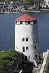 More images | |||
| Bridge Office and Shop | adjacent to a lift bridge on the Lasalle Causeway of the Rideau Canal, Kingston, ON | 44°14′05″N 76°28′30″W | 10056 | | |||
| Building B-37 | CFB Kingston, Kingston, ON | 44°14′37″N 76°27′22″W | 11324 | | |||
| Building B-39 | CFB Kingston, Kingston, ON | 44°14′44″N 76°27′20″W | 11323 | | |||
| Canadian National Railway Station | 810 Montreal Street, Kingston, ON | 44°15′14″N 76°29′06″W | 4629 | 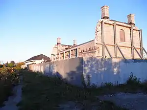 More images | |||
| Caponier | Fort Henry, Kingston, ON | 44°13′49″N 76°27′37″W | 4363 |  More images | |||
| Cataraqui Cemetery National Historic Site of Canada | Cataraqui Cemetery, 927 Purdy’s Mill Road, Kingston, ON | 44°15′40″N 76°32′32″W | 18925 | | |||
| Cedar Island Cathcart Tower | Cedar Island, Kingston, ON | 44°13′32″N 76°27′15″W | 10111 |  More images | |||
| Church of the Good Thief (Roman Catholic) | 743 King Street West, Kingston, ON | 44°13′14″N 76°31′21″W | 10402 | _-_Kingston_Ontario_Canada_(2010-04-21).jpg.webp) More images | |||
| Collins Bay Institution, Administration Building, A-1 | Federal Penitentiary at Collins Bay, Kingston, ON | 44°14′N 76°34′W | 3296 |  More images | |||
| Collins Bay Institution, Cell Block, Building B-1 | 455 Bath Road, Collins Bay Institution, Kingston, ON | 44°14′N 76°34′W | 2658 | | |||
| Commissariat Stores / Reverse Fire Chamber East | Fort Henry, Kingston, ON | 44°14′N 76°28′W | 4362 | | |||
| Commissariat Stores / Reverse Fire Chamber West | Fort Henry Defence Complex, Kingston, ON | 44°14′N 76°28′W | 4397 | | |||
| Courcelles Block | Tête de Pont barracks in Fort Frontenac, Kingston, ON | 44°14′03″N 76°28′41″W | 4331 | | |||
| Curtain Wall and Demi-Bastions | Fort Henry, Kingston, ON | 44°14′N 76°28′W | 4359 | | |||
| De Noyan Block | Fort Frontenac, Kingston, ON | 44°14′02″N 76°28′41″W | 3317 | | |||
| East Workshop | Kingston Penitentiary, Kingston, ON | 44°13′09″N 76°30′45″W | 10242 | | |||
| Elizabeth Cottage National Historic Site of Canada | 251 Brock Street, Kingston, ON | 44°13′54″N 76°29′21″W | 11909 |  | |||
| Elmhirst House | 443 Union Street West, Kingston, ON | 44°13′27″N 76°30′41″W | 19617 | | |||
| Former Prison for Women | Kingston Penitentiary, Building A3, Kingston, ON | 44°13′18″N 76°30′49″W | 10239 | 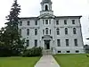 | |||
| Former Warden's Residence | 555 King Street West, Kingston, ON | 44°13′18″N 76°30′49″W | 10217 |  More images | |||
| Fort Champlain Cadet Quarters (B34) | RMC Kingston, Kingston, ON | 44°13′59″N 76°27′58″W | 2672 | | |||
| Fort Frontenac National Historic Site of Canada | 1 Ontario Street, Kingston, ON | 44°14′01″N 76°28′41″W | 12130 | 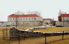 More images | |||
| Fort Henry National Historic Site of Canada | Point Henry between the mouth of Kingston harbour and a second natural harbour at the mouth of the Cataraqui River, Kingston, ON | 44°13′52″N 76°27′35″W | 7869 |  More images | |||
| Fort Lasalle Dormitory | RMC Kingston, Kingston, ON | 44°14′00″N 76°28′00″W | 4812 |  More images | |||
| Frontenac County Court House National Historic Site of Canada | 1 Court Street, Kingston, ON | 44°13′40″N 76°29′23″W | 12033 | 8845 |  | ||
| Registry Office | 1 Court Street, Kingston, ON | 44°13′38″N 76°29′27″W | 10770 | ||||
| Guardhouse No. 14 | Point Frederick, RMC Kingston, Kingston, ON | 44°14′00″N 76°28′00″W | 4785 | | |||
| Health Care Clinic (Building B-62) | CFB Kingston, Kingston, ON | 44°14′50″N 76°27′35″W | 2685 | | |||
| Heating Plant, former Commissariat Storehouse | Tête de Pont barracks in Fort Frontenac, Kingston, ON | 44°14′03″N 76°28′41″W | 4332 | | |||
| Hewitt House | RMC Kingston, Kingston, ON | 44°14′00″N 76°28′00″W | 4807 | | |||
| Inglewood | 110 Collingwood Street, Kingston, ON | 44°13′31″N 76°30′04″W | 15960 |  More images | |||
| Kingston City Hall National Historic Site of Canada | 216 Ontario Street, Kingston, ON | 44°13′48″N 76°28′49″W | 7628 |  More images | |||
| Custom House | 294 King Street East, Kingston, ON | 44°13′46″N 76°28′56″W | 3291 | 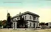 | |||
| Kingston Customs House National Historic Site of Canada | 294 King Street East, Kingston, ON | 44°13′47″N 76°28′56″W | 7538 | More images | |||
| Kingston Dry Dock National Historic Site of Canada | 55 Ontario Street, Kingston, ON | 44°13′34″N 76°29′02″W | 10531 | 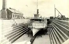 More images | |||
| Kingston Drydock Pumphouse | 55 Ontario Street, Kingston, ON | 44°13′29″N 76°28′58″W | 4696 |  More images | |||
| Kingston Fortifications National Historic Site of Canada | , Kingston, ON | 44°13′45″N 76°28′57″W | 13858 | | |||
| Kingston General Hospital National Historic Site of Canada | 76 Stuart Street, Kingston, ON | 44°13′28″N 76°29′34″W | 4218 | .jpg.webp) More images | |||
| Kingston Navy Yard National Historic Site of Canada | Campus of the Royal Military College, Kingston, ON | 44°13′28″N 76°29′34″W | 10484 | 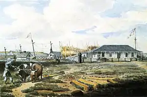 | |||
| Kingston Penitentiary National Historic Site of Canada | King Street West, Kingston, ON | 44°13′11″N 76°30′49″W | 13265 | 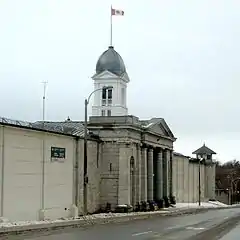 More images | |||
| LaSalle Block | Fort Frontenac, Kingston, ON | 44°14′02″N 76°28′41″W | 3318 | | |||
| Lockmaster's House | Kingston Mills Lock, Rideau Canal, Kingston, ON | 44°17′31″N 76°26′31″W | 11333 | | |||
| Main Cellblock | Kingston Penitentiary, Kingston, ON | 44°13′16″N 76°30′45″W | 3309 | ||||
| Market Square Heritage Conservation District | roughly bounded by King, Clarence, Brock, and Ontario Streets, Kingston, ON | 44°13′47″N 76°28′49″W | 7430 | | |||
| Murney Martello Tower | 18 King Street West, Kingston, ON | 44°13′20″N 76°29′26″W | 10810 | .jpg.webp) | |||
| Murney Tower National Historic Site of Canada | 18 King Street West, Kingston, ON | 44°13′21″N 76°29′26″W | 7640 | 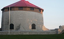 | |||
| North Lodge | 555 King Street (Kingston Penitentiary), Kingston, ON | 44°13′08″N 76°30′47″W | 3656 | | |||
| Northeast Tower Building D-1 | Collins Bay Institution, Kingston, ON | 44°14′N 76°34′W | 2761 | 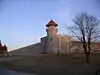 | |||
| Northwest Tower Building D-4 | Collins Bay Institution, Kingston, ON | 44°14′N 76°34′W | 2800 | | |||
| Old Fort Henry, Reverse Fire Gallery West | Fort Henry, Kingston, ON | 44°13′49″N 76°27′37″W | 4350 | .jpg.webp) | |||
| Old Kingston Post Office National Historic Site of Canada | 86 Clarence Street, Kingston, ON | 44°13′48″N 76°29′00″W | 11661 | .jpg.webp) More images | |||
| Penitentiary Towers | Kingston Penitentiary, Kingston, ON | 44°13′08″N 76°30′47″W | 16724 | | |||
| Point Frederick Buildings National Historic Site of Canada | Point Frederick, RMC Kingston, Kingston, ON | 44°13′40″N 76°28′10″W | 11616 |  More images | |||
| Portsmouth Community Correctional Centre | 508 Portsmouth Avenue, Kingston, ON | 44°14′15″N 76°31′44″W | 9769 |  More images | |||
| First Baptist Church | 110 Sydenham Street, Kingston, ON | 44°13′51″N 76°29′16″W | 15959 |  More images | |||
| Light Tower | Pigeon Island, southwest of Wolfe Island, Kingston, ON | 44°04′00″N 76°33′00″W | 13343 | | |||
| Post Office (Old) | 86 Clarence Street, Kingston, ON | 44°13′47″N 76°28′56″W | 16442 | .jpg.webp) | |||
| Prince George Hotel | 200 Ontario Street, Kingston, ON | 44°13′45″N 76°28′51″W | 1503 | .JPG.webp) More images | |||
| Redoubt | Fort Henry, Kingston, ON | 44°14′N 76°28′W | 4354 | 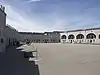 | |||
| Reverse Fire Gallery East | Fort Henry, Kingston, ON | 44°13′49″N 76°27′37″W | 4352 | | |||
| Rideau Canal National Historic Site of Canada | Rideau Street, from Kingston to Ottawa, ON | 44°40′45″N 76°13′16″W | 5727 |  More images | |||
| RMC Buildings: Gatehouse #3 | Point Frederick, RMC Kingston, Kingston, ON | 44°14′00″N 76°28′00″W | 4784 | | |||
| Rochleau Property | 68 Princess Street, Kingston, ON | 44°13′53″N 76°28′53″W | 8899 | | |||
| Ross Block | Tête de Pont barracks in Fort Frontenac, Kingston, ON | 44°14′03″N 76°28′41″W | 4335 | | |||
| Royal Military College of Canada Building 2 | RMC Kingston, Kingston, ON | 44°14′06″N 76°28′13″W | 11224 | 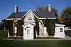 | |||
| Royal Military College of Canada Building 24 | RMC Kingston, Kingston, ON | 44°13′48″N 76°27′58″W | 11184 |  | |||
| Royal Military College of Canada Building 27 | RMC Kingston, Kingston, ON | 44°13′44″N 76°28′01″W | 11113 | 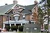 | |||
| Royal Military College of Canada Building 3 | RMC Kingston, Kingston, ON | 44°14′06″N 76°28′09″W | 11327 | 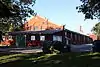 | |||
| Royal Military College of Canada Building 30a Guardhouse | RMC Kingston, Kingston, ON | 44°17′17″N 76°28′08″W | 11132 | 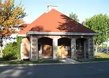 | |||
| Royal Military College of Canada Building 31 | RMC Kingston, Kingston, ON | 44°13′44″N 76°28′11″W | 11332 | 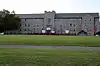 | |||
| Royal Military College of Canada Building 36 former Riding Stables | RMC Kingston, Kingston, ON | 44°14′07″N 76°28′08″W | 11101 |  | |||
| Royal Military College of Canada Building 5 | RMC Kingston, Kingston, ON | 44°14′02″N 76°28′01″W | 11197 |  | |||
| Royal Military College of Canada Building 55 | RMC Kingston, Kingston, ON | 44°13′48″N 76°28′01″W | 11325 |  | |||
| Royal Military College of Canada Building 6 | RMC Kingston, Kingston, ON | 44°14′00″N 76°28′00″W | 11244 | | |||
| Royal Military College of Canada Building 9 | Ridout Row, RMC Kingston, Kingston, ON | 44°14′03″N 76°28′06″W | 11166 | | |||
| Royal Military College of Canada Building 9a | Ridout Row, RMC Kingston, Kingston, ON | 44°14′03″N 76°28′07″W | 11168 |  | |||
| Royal Military College of Canada Commandants Residence, former Royal Navy Hospital, Building 10 | RMC Kingston, Kingston, ON | 44°14′00″N 76°28′00″W | 4391 | More images | |||
| Royal Military College of Canada Currie Building, Building No. 15 | RMC Kingston, Kingston, ON | 44°14′00″N 76°28′00″W | 4389 |  More images | |||
| Royal Military College of Canada Fort Frederick Magazine Building R30B (1846) | RMC Kingston, Kingston, ON | 44°13′38″N 76°28′12″W | 11099 |  | |||
| Royal Military College of Canada Fort Frederick Martello Tower | RMC Kingston, Kingston, ON | 44°13′59″N 76°28′01″W | 4390 |  | |||
| Royal Military College of Canada Stone Frigate (No. 23) | RMC Kingston, Kingston, ON | 44°14′00″N 76°28′00″W | 4388 |  More images | |||
| Royal Military College of Canada, MacKenzie Building | RMC Kingston, Kingston, ON | 44°14′00″N 76°28′00″W | 4382 | 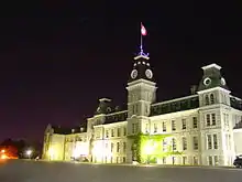 More images | |||
| Royal Military College, Old Gymnasium | RMC Kingston, Kingston, ON | 44°14′00″N 76°28′00″W | 4753 |  More images | |||
| Royal Military College, Yeo Hall Mess Building | RMC Kingston, Kingston, ON | 44°14′00″N 76°28′00″W | 4811 | 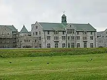 More images | |||
| St. Andrew's Manse | 146 Clergy Street East, Kingston, ON | 44°14′01″N 76°29′20″W | 10771 | | |||
| St. Andrew's Presbyterian Church | 130 Clergy Street East, Kingston, ON | 44°13′57″N 76°29′20″W | 10772 | 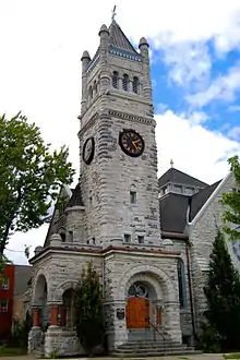 | |||
| St. George's Cathedral | 270 King Street, Kingston, ON | 44°13′46″N 76°28′56″W | 8197 | 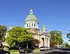 More images | |||
| St. Helen's Complex, Stone Gables | 462 King Street West, Kingston, ON | 44°13′13″N 76°30′29″W | 4710 |  | |||
| St. Helen's Complex: Red Cross Lodge | 440 King Street West, Kingston, ON | 44°13′13″N 76°30′29″W | 6220 | | |||
| St. Helen's Complex: St. Helen's | 440 King Street West, Kingston, ON | 44°13′13″N 76°30′29″W | 16462 | | |||
| St. Helen's Complex: Grant House | 440 King Street West, Kingston, ON | 44°13′13″N 76°30′29″W | 4712 | | |||
| Shelter | Cedar Island, St. Lawrence Islands National Park, Kingston, ON | 44°13′42″N 76°27′02″W | 11280 | | |||
| Shoal Tower National Historic Site of Canada | Kingston Harbour, Kingston, ON | 44°13′44″N 76°28′41″W | 11810 |  More images | |||
| Sir John A. Macdonald Gravesite National Historic Site of Canada | Cataraqui Cemetery, Kingston, ON | 44°15′44″N 76°32′32″W | 12964 | 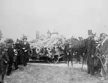 More images | |||
| South Workshop | Kingston Penitentiary, Kingston, ON | 44°13′07″N 76°30′49″W | 10243 | | |||
| Vimy Barracks (B-6) | CFB Kingston, Kingston, ON | 44°13′58″N 76°27′37″W | 9800 | | |||
| Vimy Barracks (C-1) | CFB Kingston, Kingston, ON | 44°13′58″N 76°27′37″W | 11303 | | |||
| Vimy Barracks (Forde Building, B-16) | CFB Kingston, Kingston, ON | 44°14′15″N 76°26′11″W | 9801 | | |||
| Vimy Barracks, Building B-1 | CFB Kingston, Kingston, ON | 44°14′18″N 76°26′16″W | 9867 | | |||
| Vincent Block / Administration Office | Fort Frontenac, Kingston, ON | 44°14′02″N 76°28′41″W | 3311 | | |||
| Wartman House | 86 Sunny Acres Road, Kingston, ON | 44°12′37″N 76°33′49″W | 16303 |  More images | |||
| West Workshop | Kingston Penitentiary, Kingston, ON | 44°13′08″N 76°30′50″W | 10241 | |
References
This article is issued from Wikipedia. The text is licensed under Creative Commons - Attribution - Sharealike. Additional terms may apply for the media files.