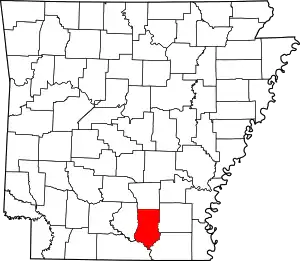
List of lakes of Bradley County, Arkansas
Lakes
- Bend Lake, 33°12′53″N 092°10′18″W, el. 75 feet (23 m) [1]
- Bilbo Lake, 33°18′02″N 092°18′52″W, el. 72 feet (22 m) [2]
- Black Lake, 33°21′09″N 091°58′25″W, el. 89 feet (27 m) [3]
- Black Lake, 33°15′48″N 092°03′12″W, el. 75 feet (23 m) [4]
- Buck Lake, 33°13′28″N 092°10′56″W, el. 75 feet (23 m) [5]
- Eagle Lake, 33°14′21″N 092°09′46″W, el. 75 feet (23 m) [6]
- Frank Lake, 33°13′01″N 092°09′00″W, el. 75 feet (23 m) [7]
- Gar Lake, 33°16′57″N 092°14′20″W, el. 75 feet (23 m) [8]
- Green Lake, 33°17′21″N 092°16′26″W, el. 72 feet (22 m) [9]
- Middle Lake, 33°13′43″N 092°09′24″W, el. 72 feet (22 m) [10]
- Moro Bay, 33°18′15″N 092°21′16″W, el. 79 feet (24 m) [11]
- Mud Lake, 33°14′02″N 092°13′36″W, el. 69 feet (21 m) [12]
- Pereogeethe Lake, 33°14′23″N 092°12′26″W, el. 62 feet (19 m) [13]
- Pine Prairie Bay, 33°15′25″N 092°14′30″W, el. 62 feet (19 m) [14]
- Raymond Lake, 33°17′47″N 092°20′04″W, el. 72 feet (22 m) [15]
- Scott Water, 33°41′51″N 092°19′41″W, el. 151 feet (46 m) [16]
- Straight Lake, 33°13′21″N 092°10′32″W, el. 72 feet (22 m) [17]
- White Oak Lake, 33°16′14″N 092°09′45″W, el. 72 feet (22 m) [18]
Reservoirs
- Atkins Pond, 33°35′56″N 092°02′48″W, el. 164 feet (50 m) [19]
- Bradley County Lake, 33°37′24″N 092°05′46″W, el. 230 feet (70 m) [20]
- Fullerton Lake, 33°38′21″N 092°01′51″W, el. 135 feet (41 m) [21]
- Reeps Lake, 33°36′14″N 092°02′35″W, el. 144 feet (44 m) [22]
- Scott Lake, 33°38′09″N 092°03′10″W, el. 161 feet (49 m) [23]
- Warren Country Club Lake, 33°34′11″N 092°04′01″W, el. 177 feet (54 m) [24]
See also
- List of lakes in Arkansas
Notes
- "Bend Lake". Geographic Names Information System. United States Geological Survey.
- "Bilbo Lake". Geographic Names Information System. United States Geological Survey.
- "Black Lake". Geographic Names Information System. United States Geological Survey.
- "Black Lake". Geographic Names Information System. United States Geological Survey.
- "Buck Lake". Geographic Names Information System. United States Geological Survey.
- "Eagle Lake". Geographic Names Information System. United States Geological Survey.
- "Frank Lake". Geographic Names Information System. United States Geological Survey.
- "Gar Lake". Geographic Names Information System. United States Geological Survey.
- "Green Lake". Geographic Names Information System. United States Geological Survey.
- "Middle Lake". Geographic Names Information System. United States Geological Survey.
- "Moro Bay". Geographic Names Information System. United States Geological Survey.
- "Mud Lake". Geographic Names Information System. United States Geological Survey.
- "Pereogeethe Lake". Geographic Names Information System. United States Geological Survey.
- "Pine Prairie Bay". Geographic Names Information System. United States Geological Survey.
- "Raymond Lake". Geographic Names Information System. United States Geological Survey.
- "Scott Water". Geographic Names Information System. United States Geological Survey.
- "Straight Lake". Geographic Names Information System. United States Geological Survey.
- "White Oak Lake". Geographic Names Information System. United States Geological Survey.
- "Atkins Pond". Geographic Names Information System. United States Geological Survey.
- "Bradley County Lake". Geographic Names Information System. United States Geological Survey.
- "Fullerton Lake". Geographic Names Information System. United States Geological Survey.
- "Reeps Lake". Geographic Names Information System. United States Geological Survey.
- "Scott Lake". Geographic Names Information System. United States Geological Survey.
- "Warren Country Club Lake". Geographic Names Information System. United States Geological Survey.
This article is issued from Wikipedia. The text is licensed under Creative Commons - Attribution - Sharealike. Additional terms may apply for the media files.
