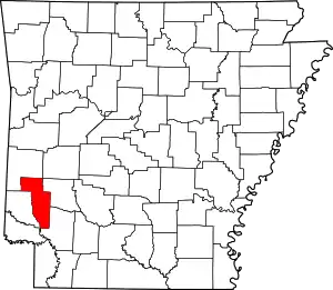
List of lakes of Howard County, Arkansas
Lakes
- Wilson Pond, 33°47′58″N 093°51′58″W, el. 302 feet (92 m) [1]
Reservoirs
- Barnes Lake, 34°00′36″N 093°56′31″W, el. 577 feet (176 m) [2]
- Briar Plant Lake One, 34°04′21″N 093°50′39″W, el. 489 feet (149 m) [3]
- Briar Plant Lake Three, 34°05′00″N 093°51′37″W, el. 489 feet (149 m) [4]
- Briar Plant Lake Two, 34°04′57″N 093°50′58″W, el. 492 feet (150 m) [5]
- Davis Lake, 34°00′35″N 093°50′34″W, el. 538 feet (164 m) [6]
- Dierks Lake, 34°08′42″N 094°06′01″W, el. 495 feet (151 m) [7]
- Gillham Lake, 34°13′37″N 094°13′48″W, el. 505 feet (154 m) [8]
- Kever Lake, 33°52′18″N 093°56′52″W, el. 374 feet (114 m) [9]
- Lake Nickels, 33°57′38″N 093°50′34″W, el. 397 feet (121 m) [10]
- McAdams Lake, 34°01′37″N 093°53′43″W, el. 646 feet (197 m) [11]
- McClure Lake, 34°00′42″N 093°50′31″W, el. 561 feet (171 m) [12]
- Millwood Lake, 33°41′45″N 093°57′41″W, el. 259 feet (79 m) [13]
- North Fork Ozan Creek Site Four Reservoir, 34°00′06″N 093°49′49″W, el. 495 feet (151 m) [14]
- Scotty Lake, 33°50′27″N 093°59′25″W, el. 285 feet (87 m) [15]
See also
- List of lakes in Arkansas
Notes
- "Wilson Pond". Geographic Names Information System. United States Geological Survey.
- "Barnes Lake". Geographic Names Information System. United States Geological Survey.
- "Briar Plant Lake One". Geographic Names Information System. United States Geological Survey.
- "Briar Plant Lake Three". Geographic Names Information System. United States Geological Survey.
- "Briar Plant Lake Two". Geographic Names Information System. United States Geological Survey.
- "Davis Lake". Geographic Names Information System. United States Geological Survey.
- "Dierks Lake". Geographic Names Information System. United States Geological Survey.
- "Gillham Lake". Geographic Names Information System. United States Geological Survey.
- "Kever Lake". Geographic Names Information System. United States Geological Survey.
- "Lake Nickels". Geographic Names Information System. United States Geological Survey.
- "McAdams Lake". Geographic Names Information System. United States Geological Survey.
- "McClure Lake". Geographic Names Information System. United States Geological Survey.
- "Millwood Lake". Geographic Names Information System. United States Geological Survey.
- "North Fork Ozan Creek Site Four Reservoir". Geographic Names Information System. United States Geological Survey.
- "Scotty Lake". Geographic Names Information System. United States Geological Survey.
This article is issued from Wikipedia. The text is licensed under Creative Commons - Attribution - Sharealike. Additional terms may apply for the media files.
