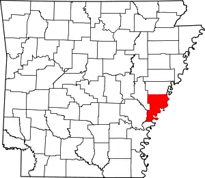
List of lakes of Phillips County, Arkansas
Lakes
- Allen Lake, 34°15′21″N 090°54′34″W, el. 157 feet (48 m) [1]
- Beaver Pond, 34°37′03″N 090°37′16″W, el. 190 feet (58 m) [2]
- Brushy Lake, 34°33′47″N 090°35′03″W, el. 174 feet (53 m) [3]
- Cargo Slash, 34°27′31″N 090°58′37″W, el. 174 feet (53 m) [4]
- Chaney Lake, 34°17′41″N 091°00′38″W, el. 144 feet (44 m) [5]
- Chute of Island 68, 34°08′41″N 090°57′49″W, el. 148 feet (45 m) [6]
- Cober Lake, 34°38′12″N 090°36′59″W, el. 180 feet (55 m) [7]
- Dustin Pond, 34°19′25″N 090°40′43″W, el. 167 feet (51 m) [8]
- Eagle Nest Lake, 34°19′47″N 091°01′13″W, el. 144 feet (44 m) [9]
- Flag Lake, 34°16′23″N 090°54′59″W, el. 151 feet (46 m) [10]
- Flat Lake, 34°13′32″N 091°03′27″W, el. 135 feet (41 m) [11]
- Forked Lake, 34°38′02″N 090°36′46″W, el. 180 feet (55 m) [12]
- Hornor Neck, 34°35′41″N 090°35′46″W, el. 174 feet (53 m) [13]
- Horseshoe Lake, 34°10′07″N 091°04′48″W, el. 138 feet (42 m) [14]
- Jentry Lake, 34°37′55″N 090°37′04″W, el. 180 feet (55 m) [15]
- Lacy Lake, 34°37′55″N 090°37′04″W, el. 180 feet (55 m) [16]
- Lake Bayou, 34°12′03″N 091°03′18″W, el. 141 feet (43 m) [17]
- Little Cypress Lake, 34°07′13″N 091°06′28″W, el. 144 feet (44 m) [18]
- Long Lake, 34°28′34″N 090°36′08″W, el. 180 feet (55 m) [19]
- Long Lake, 34°29′00″N 090°38′09″W, el. 171 feet (52 m) [20]
- Long Lake, 34°29′15″N 090°36′44″W, el. 171 feet (52 m) [21]
- Lost Lakes, 34°15′39″N 091°02′14″W, el. 144 feet (44 m) [22]
- Lower Taylor Lake, 34°07′28″N 091°04′31″W, el. 144 feet (44 m) [23]
- Old Town Lake, 34°24′35″N 090°46′15″W, el. 164 feet (50 m) [24]
- Porter Lake, 34°34′59″N 090°35′20″W, el. 174 feet (53 m) [25]
- Round Lake, 34°16′19″N 091°04′03″W, el. 141 feet (43 m) [26]
- Steelman Lake, 34°07′39″N 091°05′26″W, el. 141 feet (43 m) [27]
- Swan Lake, 34°19′15″N 090°49′32″W, el. 154 feet (47 m) [28]
- Tupelo Lake, 34°09′44″N 091°04′34″W, el. 144 feet (44 m) [29]
- Upper Taylor Lake, 34°08′42″N 091°03′47″W, el. 141 feet (43 m) [30]
- Willow Lake, 34°09′29″N 091°03′52″W, el. 141 feet (43 m) [31]
- Willow Lake, 34°19′39″N 091°02′16″W, el. 144 feet (44 m) [32]
Reservoirs
- Heritage Hill Pond, 34°30′48″N 090°37′24″W, el. 236 feet (72 m) [33]
- Jake Lake, 34°37′53″N 090°39′51″W, el. 292 feet (89 m) [34]
- Storm Creek Lake, 34°35′54″N 090°37′18″W, el. 223 feet (68 m) [35]
See also
- List of lakes in Arkansas
Notes
- "Allen Lake". Geographic Names Information System. United States Geological Survey.
- "Beaver Pond". Geographic Names Information System. United States Geological Survey.
- "Brushy Lake". Geographic Names Information System. United States Geological Survey.
- "Cargo Slash". Geographic Names Information System. United States Geological Survey.
- "Chaney Lake". Geographic Names Information System. United States Geological Survey.
- "Chute of Island 68". Geographic Names Information System. United States Geological Survey.
- "Cober Lake". Geographic Names Information System. United States Geological Survey.
- "Dustin Pond". Geographic Names Information System. United States Geological Survey.
- "Eagle Nest Lake". Geographic Names Information System. United States Geological Survey.
- "Flag Lake". Geographic Names Information System. United States Geological Survey.
- "Flat Lake". Geographic Names Information System. United States Geological Survey.
- "Forked Lake". Geographic Names Information System. United States Geological Survey.
- "Hornor Neck". Geographic Names Information System. United States Geological Survey.
- "Horseshoe Lake". Geographic Names Information System. United States Geological Survey.
- "Jentry Lake". Geographic Names Information System. United States Geological Survey.
- "Lacy Lake". Geographic Names Information System. United States Geological Survey.
- "Lake Bayou". Geographic Names Information System. United States Geological Survey.
- "Little Cypress Lake". Geographic Names Information System. United States Geological Survey.
- "Long Lake". Geographic Names Information System. United States Geological Survey.
- "Long Lake". Geographic Names Information System. United States Geological Survey.
- "Long Lake". Geographic Names Information System. United States Geological Survey.
- "Lost Lakes". Geographic Names Information System. United States Geological Survey.
- "Lower Taylor Lake". Geographic Names Information System. United States Geological Survey.
- "Old Town Lake". Geographic Names Information System. United States Geological Survey.
- "Porter Lake". Geographic Names Information System. United States Geological Survey.
- "Round Lake". Geographic Names Information System. United States Geological Survey.
- "Steelman Lake". Geographic Names Information System. United States Geological Survey.
- "Swan Lake". Geographic Names Information System. United States Geological Survey.
- "Tupelo Lake". Geographic Names Information System. United States Geological Survey.
- "Upper Taylor Lake". Geographic Names Information System. United States Geological Survey.
- "Willow Lake". Geographic Names Information System. United States Geological Survey.
- "Willow Lake". Geographic Names Information System. United States Geological Survey.
- "Heritage Hill Pond". Geographic Names Information System. United States Geological Survey.
- "Jake Lake". Geographic Names Information System. United States Geological Survey.
- "Storm Creek Lake". Geographic Names Information System. United States Geological Survey.
This article is issued from Wikipedia. The text is licensed under Creative Commons - Attribution - Sharealike. Additional terms may apply for the media files.
