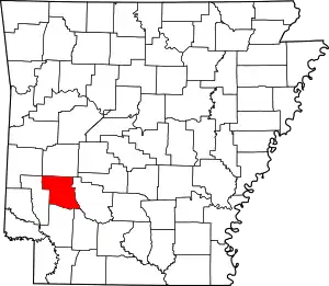
List of lakes of Pike County, Arkansas
Lakes
- Alford Lake, 34°01′43″N 093°41′52″W, el. 322 feet (98 m) [1]
- Round Pond, 34°00′42″N 093°39′18″W, el. 302 feet (92 m) [2]
Reservoirs
- Lake Greeson, 34°14′28″N 093°47′22″W, el. 548 feet (167 m) [3]
- Lake Greeson Nursery Pond, 34°09′32″N 093°44′43″W, el. 548 feet (167 m) [4]
- Mill Pond, 34°17′00″N 093°30′19″W, el. 568 feet (173 m) [5]
- North Fork Ozan Creek Watershed Number One Reservoir, 34°00′54″N 093°46′19″W, el. 492 feet (150 m) [6]
- North Fork Ozan Creek Watershed Number Two Reservoir, 34°00′34″N 093°47′18″W, el. 492 feet (150 m) [7]
- Teeter Lake, 34°00′57″N 093°45′34″W, el. 509 feet (155 m) [8]
- Tetter Lake Two, 34°00′57″N 093°45′08″W, el. 512 feet (156 m) [9]
- Womack Lake, 34°06′39″N 093°37′32″W, el. 594 feet (181 m) [10]
See also
- List of lakes in Arkansas
Notes
- "Alford Lake". Geographic Names Information System. United States Geological Survey.
- "Round Pond". Geographic Names Information System. United States Geological Survey.
- "Lake Greeson". Geographic Names Information System. United States Geological Survey.
- "Lake Greeson Nursery Pond". Geographic Names Information System. United States Geological Survey.
- "Mill Pond". Geographic Names Information System. United States Geological Survey.
- "North Fork Ozan Creek Watershed Number One Reservoir". Geographic Names Information System. United States Geological Survey.
- "North Fork Ozan Creek Watershed Number Two Reservoir". Geographic Names Information System. United States Geological Survey.
- "Teeter Lake". Geographic Names Information System. United States Geological Survey.
- "Tetter Lake Two". Geographic Names Information System. United States Geological Survey.
- "Womack Lake". Geographic Names Information System. United States Geological Survey.
This article is issued from Wikipedia. The text is licensed under Creative Commons - Attribution - Sharealike. Additional terms may apply for the media files.
