List of listed buildings in Aberlour, Moray
List
| Name | Location | Date Listed | Grid Ref. [note 1] | Geo-coordinates | Notes | LB Number [note 2] | Image |
|---|---|---|---|---|---|---|---|
| Aberlour Burial Ground, Remains Of Former Parish Church Of St Drostan, (Dunstan Or Durston) And Macpherson Grant Mausoleum | 57°28′09″N 3°13′46″W | Category B | 2347 | 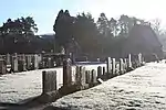 | |||
| Aberlour Home Farm, Former Gardeners' Cottages | 57°28′28″N 3°12′04″W | Category C(S) | 2348 |  | |||
| Carron House | 57°27′20″N 3°17′03″W | Category C(S) | 2362 | 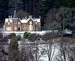 | |||
| Victoria Bridge Over River Spey | 57°28′13″N 3°13′54″W | Category A | 20873 | .jpg.webp) | |||
| Aberlour Parish Church (Church Of Scotland) | 57°28′16″N 3°13′34″W | Category B | 20866 | 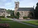 | |||
| Mary Avenue, Aberlour Primary School And Enclosing Walls | 57°28′09″N 3°13′32″W | Category B | 20870 | | |||
| Aberlour House And Terrace (Aberlour House Preparatory School) | 57°28′37″N 3°12′12″W | Category A | 2349 | | |||
| Aberlour House, Stables | 57°28′36″N 3°12′10″W | Category B | 2350 | | |||
| Aberlour House, Column | 57°28′41″N 3°12′18″W | Category B | 2351 | | |||
| Aberlour House, East Lodge, Gatepiers And Gates | 57°28′49″N 3°11′57″W | Category A | 2352 | 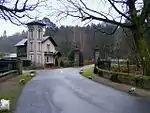 | |||
| Aberlour House, Walled Garden | 57°28′30″N 3°12′02″W | Category B | 2354 | | |||
| Craigellachie, 1 And Allandale (R) Victoria Street | 57°29′24″N 3°11′17″W | Category C(S) | 2356 | | |||
| Aberlour House, Chef's House (Aberlour House Preparatory School) | 57°28′30″N 3°12′03″W | Category B | 2361 | | |||
| 7 Victoria Terrace, Old School (Former Drill Hall) | 57°28′15″N 3°13′35″W | Category C(S) | 20874 | | |||
| 36 High Street, Heath Cottage, Former Stables/Gighouse And Garden Wall | 57°28′24″N 3°13′16″W | Category C(S) | 20867 | | |||
| 70,72 High Street | 57°28′18″N 3°13′25″W | Category C(S) | 20869 | | |||
| St Margaret's Episcopal Church And Burial Ground | 57°28′21″N 3°12′56″W | Category A | 20872 | 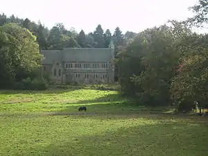 | |||
| Aberlour, The Old Manse (Former C Of S Manse), Former Stables And Garden Wall | 57°28′06″N 3°13′48″W | Category B | 5276 | | |||
| Kinermony House, Gate Lodge And Garage | 57°27′41″N 3°14′46″W | Category C(S) | 2360 | | |||
| Aberlour Orphanage, Clock Tower | 57°28′19″N 3°13′02″W | Category C(S) | 20865 | | |||
| 54 High Street, Old Free Church Manse And Garden Wall | 57°28′21″N 3°13′22″W | Category B | 20868 | | |||
| Aberlour, Bridge Of Skirdustan Over Burn Of Aberlour Or Lour Burn | 57°28′06″N 3°13′45″W | Category C(S) | 5277 | | |||
| Aberlour House, West Lodge, Gatepiers And Gates | 57°28′34″N 3°12′39″W | Category A | 2353 | | |||
| Craigellachie, Old Bridge Over River Spey (Telford Bridge) | 57°29′29″N 3°11′38″W | Category A | 2357 | | |||
| Fisherton | 57°28′31″N 3°12′45″W | Category B | 2358 | | |||
| Kinermony House And Garden Wall | 57°27′44″N 3°14′44″W | Category B | 2359 | | |||
| Charlestown Of Aberlour, The Mash Tun Bar | 57°28′15″N 3°13′39″W | Category C(S) | 49987 | 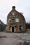 | |||
| Queen's Road, Fleming Hall And Cottage Abutting Rear Gable | 57°28′11″N 3°13′25″W | Category B | 20871 | | |||
| Craigellachie, John Street, Primary School And Front Railings | 57°29′24″N 3°11′08″W | Category B | 2355 | |
Key
The scheme for classifying buildings in Scotland is:
- Category A: "buildings of national or international importance, either architectural or historic; or fine, little-altered examples of some particular period, style or building type."[1]
- Category B: "buildings of regional or more than local importance; or major examples of some particular period, style or building type, which may have been altered."[1]
- Category C: "buildings of local importance; lesser examples of any period, style, or building type, as originally constructed or moderately altered; and simple traditional buildings which group well with other listed buildings."[1]
In March 2016 there were 47,288 listed buildings in Scotland. Of these, 8% were Category A, and 50% were Category B, with the remaining 42% being Category C.[2]
See also
Notes
- Sometimes known as OSGB36, the grid reference (where provided) is based on the British national grid reference system used by the Ordnance Survey.
• "Guide to National Grid". Ordnance Survey. Retrieved 2007-12-12.
• "Get-a-map". Ordnance Survey. Retrieved 2007-12-17. - Historic Environment Scotland assign a unique alphanumeric identifier to each designated site in Scotland, for listed buildings this always begins with "LB", for example "LB12345".
References
- All entries, addresses and coordinates are based on data from Historic Scotland. This data falls under the Open Government Licence
- "What is Listing?". Historic Environment Scotland. Retrieved 29 May 2018.
- Scotland's Historic Environment Audit 2016 (PDF). Historic Environment Scotland and the Built Environment Forum Scotland. pp. 15–16. Retrieved 29 May 2018.
This article is issued from Wikipedia. The text is licensed under Creative Commons - Attribution - Sharealike. Additional terms may apply for the media files.