List of listed buildings in Airdrie, North Lanarkshire
List
| Name | Location | Date Listed | Grid Ref. [note 1] | Geo-coordinates | Notes | LB Number [note 2] | Image |
|---|---|---|---|---|---|---|---|
| Bank Street, The Townhouse | 55°52′00″N 3°58′50″W | Category B | 20926 |  | |||
| Towers Road, Wester Moffat Hospital, Wester Moffat House | 55°52′07″N 3°56′27″W | Category B | 20930 | | |||
| 2-10 (Even Nos) Bank Street, New Cross Corner | 55°51′59″N 3°58′50″W | Category B | 20936 | | |||
| 1 Kippen Street, Rochsolloch Primary School Including Boundary Wall And Railings | 55°51′43″N 3°59′49″W | Category C(S) | 20943 | 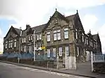 | |||
| 14 Anderson Street | 55°52′01″N 3°58′56″W | Category C(S) | 48540 | | |||
| 16-20 (Even Nos) And 24-28 (Even Nos) Anderson Street | 55°52′01″N 3°58′58″W | Category B | 48541 | | |||
| East High Street, Fruitfield House | 55°52′09″N 3°58′51″W | Category C(S) | 48548 | | |||
| Grahamshill Street, Annfield | 55°52′06″N 3°57′36″W | Category C(S) | 48552 | | |||
| North Biggar Road, Stanley Old College Gate Fragment | 55°52′07″N 3°58′06″W | Category B | 48556 | | |||
| 4 And 6 Victoria Place, (Swiss Villa And Clydesdale) Including Gates And Railings | 55°51′48″N 3°58′58″W | Category B | 48560 | | |||
| Wellwynd, Former West Parish Church | 55°51′59″N 3°59′03″W | Category B | 20921 | 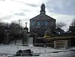 | |||
| Wellwynd, Wellwynd Church, Church Of Scotland | 55°52′03″N 3°58′59″W | Category C(S) | 20923 | | |||
| 5-11 (Odd Nos), 4 And 6 Dornoch Way, Former Cairnhill Stables | 55°51′16″N 3°59′16″W | Category B | 20927 | | |||
| 24 Victoria Place, The Red House Including Boundary Wall And Gatepiers | 55°51′46″N 3°59′12″W | Category B | 20951 | | |||
| 54 Victoria Place, The Anchorage Including Boundary Wall And Gatepiers | 55°51′44″N 3°59′25″W | Category B | 48563 | | |||
| 23 And 25 Wellwynd | 55°52′03″N 3°59′01″W | Category C(S) | 20929 | | |||
| Springwells Avenue, St Paul's Episcopal Church Including Church Hall And Boundary Wall | 55°52′07″N 3°57′56″W | Category C(S) | 20931 | 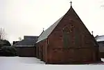 | |||
| Johnston Street, Flowerhill Parish Church, Church Of Scotland, Including Church Hall And Manse | 55°52′01″N 3°58′34″W | Category B | 20932 | 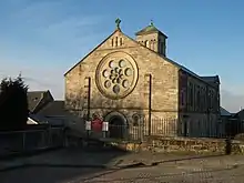 | |||
| Broomknoll Street, Monklands District Council Housing Department | 55°51′53″N 3°58′48″W | Category C(S) | 20938 | | |||
| 5 Graham Street Including Flanking Walls | 55°51′59″N 3°58′48″W | Category B | 20940 | | |||
| 56 Stirling Street, Airdrie Savings Bank Including Gatepiers And Gates | 55°51′58″N 3°58′59″W | Category B | 20949 | | |||
| 6, 8 And 8A East High Street | 55°52′07″N 3°58′55″W | Category C(S) | 48550 | | |||
| Graham Street, Airdrie Baptist Church Including Boundary Wall And Gatepiers | 55°52′00″N 3°58′33″W | Category C(S) | 48551 | | |||
| North Biggar Road, 2 And 3 Stanley Park Including Boundary Wall And Gatepiers | 55°52′07″N 3°58′08″W | Category C(S) | 48555 | 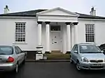 | |||
| 10 Stirling Street | 55°51′58″N 3°58′53″W | Category B | 48559 | | |||
| 16 And 18 North Bridge Street, Airdrie Children's Board | 55°52′08″N 3°58′58″W | Category B | 20944 | 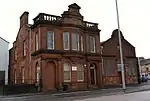 | |||
| Broomknoll Street, Broomknoll Parish Church, Church Of Scotland | 55°51′54″N 3°58′51″W | Category C(S) | 48544 | | |||
| 2 East High Street | 55°52′07″N 3°58′56″W | Category C(S) | 48549 | | |||
| 2-10 (Even Nos) Hallcraig Street, Airdrie Market Building | 55°52′02″N 3°58′49″W | Category C(S) | 48553 | | |||
| Mulvey Crescent, Airdrie War Memorial | 55°51′50″N 3°59′45″W | Category C(S) | 48554 | 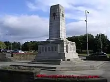 | |||
| 80-82 (Even Nos), 86 South Bridge Street And 4 Anderson Street | 55°52′01″N 3°58′53″W | Category C(S) | 48558 | | |||
| Hallcraig Street, St Margaret's Roman Catholic Church Including Presbytery And Boundary Wall | 55°52′04″N 3°58′32″W | Category B | 20924 | | |||
| Airdrie Road, Clarkston Parish Church, Church Of Scotland | 55°52′22″N 3°56′44″W | Category C(S) | 20925 | | |||
| Stirling Street, Sir John Wilson Town Hall Including Gatepiers | 55°51′56″N 3°59′01″W | Category B | 20947 | 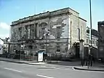 | |||
| Wellwynd, Airdrie Public Library | 55°51′59″N 3°58′59″W | Category C(S) | 20950 | | |||
| 31 Victoria Place, Flowerhill Manse Including Boundary Wall And Gatepiers | 55°51′46″N 3°59′04″W | Category C(S) | 48562 | | |||
| Bell Street, Methodist Church | 55°52′00″N 3°59′06″W | Category B | 20922 | | |||
| Arran Drive, Commonhead, Street, Arranview Including Gatepiers | 55°52′23″N 3°59′16″W | Category B | 20928 | | |||
| Motherwell Street, Rawyards House | 55°52′28″N 3°57′47″W | Category C(S) | 20933 | | |||
| Bank Street, Former Royal Bank Of Scotland | 55°52′00″N 3°58′50″W | Category B | 20937 | 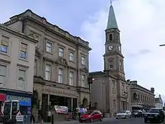 | |||
| 77-83 (Odd Nos) High Street | 55°52′04″N 3°59′07″W | Category C(S) | 20942 | | |||
| Coatdyke, Centenary Avenue, Railway Viaduct | 55°51′49″N 4°00′09″W | Category B | 49409 | | |||
| 93, 95 High Street, Charlie's Bar | 55°52′03″N 3°59′08″W | Category C(S) | 20934 | | |||
| 35 Quarry Road Including Boundary Wall | 55°52′20″N 3°58′54″W | Category C(S) | 20946 | | |||
| 12-20 (Even Nos) Bank Street | 55°52′01″N 3°58′51″W | Category C(S) | 48543 | | |||
| 40 South Bridge Street | 55°52′04″N 3°58′56″W | Category C(S) | 48557 | | |||
| Anderson Street, Airdrie Arts Centre | 55°52′00″N 3°58′54″W | Category B | 20935 | | |||
| Chapel Street, Educational Resource Centre, Formerly Chapelside Primary School, Including Boundary Walls, Gatepiers, Gates And Railings | 55°52′17″N 3°58′35″W | Category B | 20939 | | |||
| 7 Graham Street | 55°51′59″N 3°58′47″W | Category C(S) | 20941 | | |||
| 11-13 (Odd Nos) Stirling Street | 55°51′57″N 3°58′53″W | Category B | 20948 | | |||
| Broomknoll Street, Ebenezer Congregational Chapel | 55°51′56″N 3°58′49″W | Category C(S) | 48545 | | |||
| 8-16 (Even Nos) Broomknoll Street | 55°51′55″N 3°58′51″W | Category C(S) | 48546 | | |||
| 18 And 20 Broomknoll Street | 55°51′55″N 3°58′51″W | Category C(S) | 48547 | | |||
| 26 (Upper And Lower Flat) Victoria Place, Dalmagarry And Cairnbaan Including Boundary Wall And Gatepiers | 55°51′46″N 3°59′13″W | Category C(S) | 48561 | |
Key
The scheme for classifying buildings in Scotland is:
- Category A: "buildings of national or international importance, either architectural or historic; or fine, little-altered examples of some particular period, style or building type."[1]
- Category B: "buildings of regional or more than local importance; or major examples of some particular period, style or building type, which may have been altered."[1]
- Category C: "buildings of local importance; lesser examples of any period, style, or building type, as originally constructed or moderately altered; and simple traditional buildings which group well with other listed buildings."[1]
In March 2016 there were 47,288 listed buildings in Scotland. Of these, 8% were Category A, and 50% were Category B, with the remaining 42% being Category C.[2]
Notes
- Sometimes known as OSGB36, the grid reference (where provided) is based on the British national grid reference system used by the Ordnance Survey.
• "Guide to National Grid". Ordnance Survey. Retrieved 2007-12-12.
• "Get-a-map". Ordnance Survey. Retrieved 2007-12-17. - Historic Environment Scotland assign a unique alphanumeric identifier to each designated site in Scotland, for listed buildings this always begins with "LB", for example "LB12345".
References
- All entries, addresses and coordinates are based on data from Historic Scotland. This data falls under the Open Government Licence
- "What is Listing?". Historic Environment Scotland. Retrieved 29 May 2018.
- Scotland's Historic Environment Audit 2016 (PDF). Historic Environment Scotland and the Built Environment Forum Scotland. pp. 15–16. Retrieved 29 May 2018.
This article is issued from Wikipedia. The text is licensed under Creative Commons - Attribution - Sharealike. Additional terms may apply for the media files.