List of listed buildings in Alloa, Clackmannanshire
List
| Name | Location | Date Listed | Grid Ref. [note 1] | Geo-coordinates | Notes | LB Number [note 2] | Image |
|---|---|---|---|---|---|---|---|
| Former Library And Museum Hall (Now Weir Pumps), Church Street | 56°06′50″N 3°47′42″W | Category C(S) | 20990 |  | |||
| 11 Bedford Place Fenton House | 56°06′50″N 3°47′51″W | Category B | 20994 | | |||
| 4, 5 Grange Road | 56°06′51″N 3°48′03″W | Category C(S) | 21003 | | |||
| Bedford Place, K6 Telephone Kiosk At Former General Post Office | 56°06′48″N 3°47′41″W | Category B | 21027 | | |||
| Ludgate, Alloa North Parish Church | 56°07′06″N 3°47′50″W | Category B | 21028 | | |||
| 6-10 (Even Nos) Mar Street, Hope Bakers, With Ovens | 56°06′54″N 3°47′31″W | Category B | 21030 | | |||
| 17, 19, 21 High Street Bank Of Scotland Building | 56°06′55″N 3°47′29″W | Category B | 20965 | | |||
| 13, 15 Mar Street Former Liberal Club | 56°06′53″N 3°47′33″W | Category B | 20967 | | |||
| Ochil House Marshill And Mar Street | 56°06′57″N 3°47′36″W | Category B | 20975 | | |||
| Dovecot, Near Auchinbaird Crossing Fishcross | 56°08′05″N 3°46′28″W | Category B | 1981 | | |||
| Sauchie Parish Church New Sauchie | 56°07′50″N 3°46′33″W | Category C(S) | 1982 | | |||
| 12 Bedford Place Including Garden Walls And Gate | 56°06′49″N 3°47′53″W | Category C(S) | 20998 | | |||
| Mercat Cross At 16 Bank Street | 56°06′50″N 3°47′38″W | Category B | 20987 | | |||
| St Mungo's Parish Church Bedford Place | 56°06′49″N 3°47′50″W | Category B | 20997 | | |||
| 13 Grange Road | 56°06′52″N 3°48′06″W | Category C(S) | 21005 | | |||
| Coach House Theatre, Tullibody Road, Former Inglewood East Lodge And Garage Block | 56°07′26″N 3°48′14″W | Category B | 21021 | 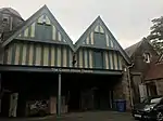 | |||
| Alloa Old Kirkyard, Kirkgate | 56°06′47″N 3°47′27″W | Category B | 20954 | | |||
| Gatepiers, Formerly Of Alloa House, Lime Tree Walk | 56°06′40″N 3°47′39″W | Category B | 20958 | | |||
| 1, 3 Coalgate | 56°06′51″N 3°47′32″W | Category C(S) | 20962 | | |||
| Bank Street Coalgate And Stripehead Former Gas Showroom | 56°06′48″N 3°47′39″W | Category B | 20982 | | |||
| Former Social Security Offices, 16 Bank Street | 56°06′51″N 3°47′38″W | Category C(S) | 20986 | | |||
| Tullibody Old Kirk | 56°08′13″N 3°50′08″W | Category A | 1972 | | |||
| St. Serf's Church, Tullibody | 56°08′15″N 3°50′07″W | Category B | 1974 | | |||
| Parkhead Road, Sauchie Hospital Lodge ,Including Gatepiers And Boundary Walls | 56°07′31″N 3°47′06″W | Category C(S) | 49983 | | |||
| Alloa West Church Bedford Place And Ludgate | 56°06′50″N 3°47′47″W | Category C(S) | 20993 | | |||
| Stirling Road, Cowden Park | 56°07′07″N 3°48′22″W | Category C(S) | 21011 | | |||
| The Gean House South Lodge | 56°07′22″N 3°48′40″W | Category C(S) | 21015 | | |||
| Garden Walls Garden House, And Walled Garden West Of House, Carsebridge House | 56°07′27″N 3°46′37″W | Category B | 21023 | | |||
| Napoleon Pillar Carsebridge House | 56°07′26″N 3°46′34″W | Category B | 21024 | | |||
| St John's Episcopal Church Limetree Walk | 56°06′46″N 3°47′37″W | Category B | 20957 | | |||
| 41-45 Mill Street And 2 High Street | 56°06′54″N 3°47′30″W | Category B | 20963 | | |||
| Former County Offices, 70 Drysdale Street | 56°06′59″N 3°47′33″W | Category C(S) | 20971 | | |||
| 9, 11 Bank Street Clydesdale Bank | 56°06′50″N 3°47′34″W | Category C(S) | 20979 | | |||
| Tullibody Old Bridge Over River Devon, Bridgend | 56°08′06″N 3°51′27″W | Category A | 1977 | 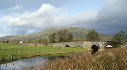 | |||
| Sauchie Tower (Or Devon Tower) | 56°08′29″N 3°46′40″W | Category A | 1980 | 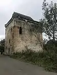 | |||
| Claremont, South African War Memorial | 56°07′02″N 3°47′53″W | Category B | 46269 | | |||
| Sauchie, Fairfield Road (At Corner Of Mar Place), Sauchie War Memorial | 56°07′33″N 3°47′02″W | Category B | 49529 | | |||
| Sauchie, Fairfield Road (At Corner Of Mar Place), Sauchie Public Hall Including Boundary Wall To South And East | 56°07′34″N 3°47′02″W | Category C(S) | 49530 | | |||
| Greenside Street, Kilncraigs Despatch Warehouse | 56°06′46″N 3°47′24″W | Category A | 49975 | | |||
| 21 Claremont, Claremont Grove Including Outbuildings, Summerhouse, Boundary Walls And Gatepiers And Garden Features | 56°07′06″N 3°48′06″W | Category C(S) | 50151 | | |||
| Greenside Street, Elim Pentecostal Church (Formerly Greenside Mission Chapel) | 56°06′48″N 3°47′28″W | Category C(S) | 51623 | | |||
| 18-22 Bank Street | 56°06′50″N 3°47′39″W | Category C(S) | 20988 | | |||
| War Memorial Gusset Of Bank Street And Church Street | 56°06′49″N 3°47′42″W | Category B | 20989 | | |||
| Royal Oak Hotel And 3, 5 Bedford Place | 56°06′49″N 3°47′45″W | Category C(S) | 20991 | | |||
| 13 Bedford Place Bedford House (Regional Council Offices) | 56°06′50″N 3°47′54″W | Category B | 20995 | | |||
| 16 And 16A Bedford Place, Westray | 56°06′49″N 3°47′57″W | Category B | 21000 | | |||
| Northern Glass Cone, Alloa Glass Works, Glasshouse Loan | 56°06′41″N 3°48′09″W | Category A | 21008 | | |||
| Primrose Street And Primrose Place, Former Public Baths And Gymnasium | 56°07′01″N 3°47′31″W | Category B | 21009 | | |||
| Greenfield House (Now District Council Offices) | 56°07′09″N 3°47′41″W | Category B | 21010 | | |||
| Claremont House, Claremont | 56°07′12″N 3°48′17″W | Category C(S) | 21014 | | |||
| Carsebridge House, Carsebridge Road (Excluding Stables Built In 1911) | 56°07′26″N 3°46′33″W | Category B | 21022 | 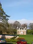 | |||
| 19 Mar Street YMCA Building (Original Front House Block Only) | 56°06′54″N 3°47′35″W | Category B | 20968 | | |||
| County And Police Buildings, Mar Street And Drysdale Street | 56°06′58″N 3°47′36″W | Category B | 20970 | | |||
| Mar Place House Mar Place | 56°06′59″N 3°47′37″W | Category C(S) | 20974 | | |||
| 25 And 27 Bank Street, 1, 3, 5, 7 And 9 Union Street, 2 And 12 Brewhouse Court, 20 And 22 Coalgate, Former Meadow Brewery And Union Club | 56°06′50″N 3°47′37″W | Category B | 20981 | | |||
| Crown Hotel Bank Street | 56°06′51″N 3°47′36″W | Category C(S) | 20984 | | |||
| Old Post Office And Savings Bank (Upper Floors Now Part Of Social Security Offices Etc) Bank Street | 56°06′51″N 3°47′37″W | Category C(S) | 20985 | | |||
| Arnsbrae House Including Terrace | 56°07′30″N 3°49′16″W | Category B | 1967 | | |||
| Lornshill, Farmhouse | 56°07′50″N 3°49′13″W | Category B | 1975 | | |||
| Doocot, New Mills Crossing | 56°07′50″N 3°51′05″W | Category B | 1976 | | |||
| King O'Muirs, Farm House | 56°08′24″N 3°48′26″W | Category C(S) | 1979 | | |||
| Former St Mungo's Parish Hall, 10 Bedford Place, (1-8) St Mungo's Wynd Including Boundary Wall And Gatepiers | 56°06′48″N 3°47′47″W | Category C(S) | 49851 | | |||
| 17 Mar Street, Job Centre (Former Co-Operative Society Headquarters) | 56°06′54″N 3°47′34″W | Category B | 49859 | | |||
| 9, 9A Bedford Place Old West Manse | 56°06′49″N 3°47′47″W | Category B | 20992 | | |||
| 33 Claremont | 56°07′10″N 3°48′13″W | Category C(S) | 21012 | | |||
| Pavilion, Paton & Baldwin's Recreation Ground, Tullibody Road | 56°07′18″N 3°48′11″W | Category B | 21018 | | |||
| Inglewood, Tullibody Road | 56°07′35″N 3°48′14″W | Category A | 21019 | | |||
| Sunnyside Road, Alloa Co-Operative Sports Pavilion | 56°07′14″N 3°47′24″W | Category B | 21025 | | |||
| Old Parish Church Of St Mungo, Alloa Old Kirkyard, Kirkgate | 56°06′47″N 3°47′33″W | Category B | 20952 | | |||
| Mar And Kellie Mausoleum, Alloa, Old Kirkyard, Kirkgate | 56°06′47″N 3°47′32″W | Category B | 20953 | | |||
| Stable Block Of Former Alloa House | 56°06′46″N 3°47′12″W | Category B | 20960 | | |||
| 21 Mar Street | 56°06′55″N 3°47′35″W | Category B | 20969 | | |||
| Moncrieff Uf Church Drysdale Street | 56°07′00″N 3°47′35″W | Category C(S) | 20973 | | |||
| Marshill, Marchill House (Regional Offices) | 56°06′59″N 3°47′46″W | Category C(S) | 20977 | | |||
| Former Chalmers Church, Bank Street Junction With Mill Street | 56°06′52″N 3°47′36″W | Category B | 20983 | | |||
| Cross, Hawk Hill West Of Former East Lodge To Alloa House | 56°06′50″N 3°46′06″W | Category B | 1984 | | |||
| Ludgate, Claremont Workshops, North Building
(Former Ludgate Infant School) Including Boundary Walls, Railings, Gatepiers And Gate |
56°06′58″N 3°47′52″W | Category C(S) | 51392 | | |||
| Former Alloa Burgh School (St Mungo's Infant Department) Bedford Place | 56°06′47″N 3°47′44″W | Category C(S) | 20996 | | |||
| St John's Rectory, Grange Road | 56°06′52″N 3°48′04″W | Category B | 21004 | | |||
| 40, 40A Grange Road | 56°06′53″N 3°48′14″W | Category C(S) | 21006 | | |||
| The Gean House, (Including Terraces, Forecourt, Walled Garden And Summerhouse), Tullibody Road And Claremont | 56°07′31″N 3°48′43″W | Category A | 21016 | 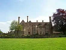 | |||
| Inglewood West Lodge And Gates, Tullibody Road | 56°07′27″N 3°48′16″W | Category B | 21020 | | |||
| East Vennel And Old Bridge Street, Thistle Brewery | 56°06′54″N 3°47′22″W | Category B | 21026 | | |||
| Marshill, Marcelle (Regional Offices) | 56°06′59″N 3°47′49″W | Category B | 20978 | | |||
| Arnsbrae House Stableblock | 56°07′29″N 3°49′26″W | Category C(S) | 1968 | | |||
| Arnsbrae House Lodge | 56°07′25″N 3°49′23″W | Category C(S) | 1969 | | |||
| 3 And 3A Grange Road | 56°06′51″N 3°48′01″W | Category C(S) | 21002 | | |||
| Grange Road, St John's Primary School (Former Grange School) Including Boundary Walls | 56°06′59″N 3°48′21″W | Category B | 21007 | | |||
| 35 Claremont, Craigmyle | 56°07′10″N 3°48′14″W | Category C(S) | 21013 | | |||
| Gean House North Lodge To Tullibody Road | 56°07′36″N 3°48′35″W | Category B | 21017 | | |||
| Dunmar House Hotel | 56°07′33″N 3°49′02″W | Category B | 21029 | | |||
| Alloa Tower | 56°06′45″N 3°47′18″W | Category A | 20959 | 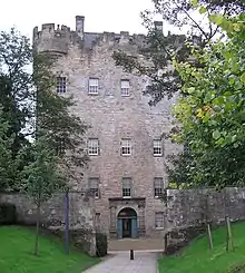 | |||
| Moncrieff House 72 Drysdale Street | 56°06′59″N 3°47′34″W | Category C(S) | 20972 | | |||
| Keilarsbrae House | 56°07′29″N 3°46′46″W | Category C(S) | 1983 | | |||
| Greenside Street, Old Paton's Mill School | 56°06′48″N 3°47′26″W | Category C(S) | 51622 | | |||
| 14 Bedford Place | 56°06′49″N 3°47′53″W | Category B | 20999 | | |||
| 1, 1A And 2 Grange Road | 56°06′51″N 3°47′59″W | Category C(S) | 21001 | | |||
| 25 Kirkgate (Star House) | 56°06′48″N 3°47′35″W | Category A | 20955 | | |||
| Greenside Street, Kilncraigs | 56°06′48″N 3°47′24″W | Category A | 20956 | 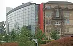 | |||
| 1,3 Mar Street And 31 Mill Street, Former Bank Of Scotland Building | 56°06′53″N 3°47′32″W | Category B | 20966 | | |||
| Town Hall, Marshill | 56°06′59″N 3°47′44″W | Category C(S) | 20976 | 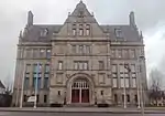 | |||
| 19, 21, 23 Bank Street | 56°06′50″N 3°47′36″W | Category B | 20980 | | |||
| Tullibody Old Kirkyard | 56°08′13″N 3°50′08″W | Category B | 1973 | 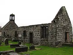 | |||
| Iron Bridge Over River Devon At Cambus | 56°07′32″N 3°50′47″W | Category A | 1985 | 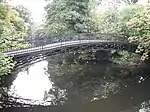 |
Key
The scheme for classifying buildings in Scotland is:
- Category A: "buildings of national or international importance, either architectural or historic; or fine, little-altered examples of some particular period, style or building type."[1]
- Category B: "buildings of regional or more than local importance; or major examples of some particular period, style or building type, which may have been altered."[1]
- Category C: "buildings of local importance; lesser examples of any period, style, or building type, as originally constructed or moderately altered; and simple traditional buildings which group well with other listed buildings."[1]
In March 2016 there were 47,288 listed buildings in Scotland. Of these, 8% were Category A, and 50% were Category B, with the remaining 42% being Category C.[2]
Notes
- Sometimes known as OSGB36, the grid reference (where provided) is based on the British national grid reference system used by the Ordnance Survey.
• "Guide to National Grid". Ordnance Survey. Retrieved 2007-12-12.
• "Get-a-map". Ordnance Survey. Retrieved 2007-12-17. - Historic Environment Scotland assign a unique alphanumeric identifier to each designated site in Scotland, for listed buildings this always begins with "LB", for example "LB12345".
References
- All entries, addresses and coordinates are based on data from Historic Scotland. This data falls under the Open Government Licence
- "What is Listing?". Historic Environment Scotland. Retrieved 29 May 2018.
- Scotland's Historic Environment Audit 2016 (PDF). Historic Environment Scotland and the Built Environment Forum Scotland. pp. 15–16. Retrieved 29 May 2018.
This article is issued from Wikipedia. The text is licensed under Creative Commons - Attribution - Sharealike. Additional terms may apply for the media files.