List of listed buildings in Banff, Aberdeenshire
List
| Name | Location | Date Listed | Grid Ref. [note 1] | Geo-coordinates | Notes | LB Number [note 2] | Image |
|---|---|---|---|---|---|---|---|
| 11, 12 Sandyhill Road | 57°39′42″N 2°31′28″W | Category C(S) | 22085 |  | |||
| 13 Sandyhill Road and Rear Garden Wall | 57°39′42″N 2°31′28″W | Category C(S) | 22086 | | |||
| 1, 3 Strait Path | 57°39′53″N 2°31′19″W | Category C(S) | 22105 | | |||
| Water Path, Path House Garden Walls | 57°39′56″N 2°31′21″W | Category B | 22110 | | |||
| 3 Water Path | 57°39′55″N 2°31′17″W | Category B | 22112 | | |||
| 68, 70 Castle Street and Rear Courtyard Walls | 57°40′06″N 2°31′25″W | Category C(S) | 21963 | | |||
| 19 Clunie Street, former Free School | 57°40′07″N 2°31′31″W | Category B | 21975 | | |||
| 11 Deveronside | 57°40′00″N 2°31′15″W | Category B | 21983 | | |||
| Duff House Walled Garden | 57°39′45″N 2°31′13″W | Category B | 21989 | | |||
| 1 George Street and Garden Walls | 57°40′04″N 2°31′25″W | Category B | 21996 | | |||
| High Street, The Cottage, St Brandon's Close | 57°39′48″N 2°31′22″W | Category C(S) | 22026 | | |||
| 40 High Street, Royal Bank Of Scotland | 57°39′54″N 2°31′23″W | Category B | 22034 | | |||
| Low Street, Court House | 57°39′47″N 2°31′19″W | Category B | 22039 | | |||
| 31, 33 Low Street | 57°39′51″N 2°31′20″W | Category C(S) | 22045 | | |||
| 43, 45, 47 Low Street and Rear Garden Walls | 57°39′52″N 2°31′20″W | Category B | 22047 | | |||
| 49, 51 Low Street, Clydesdale Bank | 57°39′52″N 2°31′20″W | Category B | 22048 | | |||
| 28 Low Street (with 48 Bridge Street) | 57°39′50″N 2°31′17″W | Category C(S) | 22059 | | |||
| 3 Old Castlegate | 57°39′54″N 2°31′24″W | Category C(S) | 22065 | | |||
| 7 Old Castlegate | 57°39′55″N 2°31′23″W | Category C(S) | 22067 | | |||
| Old Market Place, Former Smithy | 57°39′52″N 2°31′04″W | Category B | 22072 | | |||
| 5, 6 Sandyhill Road and Rear Garden Wall | 57°39′44″N 2°31′27″W | Category C(S) | 22081 | | |||
| 6 Back Path and Garden Walls | 57°39′48″N 2°31′22″W | Category B | 21878 | | |||
| 4, 6 Boyndie Street | 57°39′54″N 2°31′26″W | Category B | 21887 | | |||
| 13, 15 Bridge Street | 57°39′51″N 2°31′10″W | Category C(S) | 21898 | | |||
| 41-47 (Odd Nos) Bridge Street | 57°39′50″N 2°31′15″W | Category C(S) | 21900 | | |||
| 8 Bridge Street | 57°39′52″N 2°31′09″W | Category C(S) | 21903 | | |||
| 13 Campbell Street | 57°40′09″N 2°31′41″W | Category C(S) | 21916 | | |||
| 5 Carmelite Street | 57°39′54″N 2°31′17″W | Category C(S) | 21928 | | |||
| 29 Castle Street and rear Garden Walls | 57°39′59″N 2°31′26″W | Category B | 21940 | | |||
| 37 Castle Street, Seafield House | 57°40′01″N 2°31′27″W | Category B | 21942 | | |||
| 47 Castle Street, Castle Bar and Garden Walls | 57°40′03″N 2°31′26″W | Category C(S) | 21945 | | |||
| South Colleonard with Urns, Gates and Gatepiers | 57°39′10″N 2°33′39″W | Category A | 6662 | | |||
| 17 Sandyhill Road | 57°39′41″N 2°31′30″W | Category C(S) | 22088 | | |||
| Seafield Street, Methodist Church | 57°40′01″N 2°31′31″W | Category C(S) | 22093 | | |||
| 1 St Catherine Street, St Catherine's | 57°40′04″N 2°31′26″W | Category A | 22098 | | |||
| 4 Water Path | 57°39′55″N 2°31′16″W | Category B | 22113 | | |||
| 62, 64 Castle Street | 57°40′05″N 2°31′25″W | Category C(S) | 21961 | | |||
| 27 Clunie Street | 57°40′07″N 2°31′34″W | Category C(S) | 21977 | | |||
| Clunie Street, Chalmers Hospital (original building only) | 57°40′08″N 2°31′28″W | Category B | 21978 | 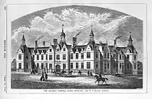 | |||
| Duff House | 57°39′31″N 2°31′12″W | Category A | 21985 | 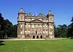 | |||
| Duff House Mausoleum | 57°39′15″N 2°32′14″W | Category A | 21988 | 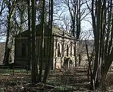 | |||
| 11 Fife Street and rear Garden Walls | 57°40′05″N 2°31′33″W | Category B | 21993 | | |||
| 13 Fife Street and Rear Garden Walls | 57°40′06″N 2°31′33″W | Category B | 21994 | | |||
| 3 George Street | 57°40′04″N 2°31′23″W | Category C(S) | 21998 | | |||
| Harbour Place, The Vaults | 57°40′05″N 2°31′21″W | Category C(S) | 22001 | | |||
| 1 High Shore | 57°39′54″N 2°31′16″W | Category A | 22004 | | |||
| High Shore, Banff Police Station and Garden Wall | 57°39′57″N 2°31′16″W | Category B | 22009 | | |||
| 29, 31 High Street | 57°39′49″N 2°31′24″W | Category B | 22018 | | |||
| High Street, Banff Museum and Library | 57°39′49″N 2°31′23″W | Category C(S) | 22024 | | |||
| High Street, Episcopal Rectory and Front Railings | 57°39′51″N 2°31′23″W | Category B | 22030 | | |||
| 30, 32 High Street | 57°39′51″N 2°31′23″W | Category B | 22032 | | |||
| 1 Institution Terrace | 57°39′46″N 2°31′26″W | Category B | 22036 | | |||
| 15, 17 Low Street | 57°39′49″N 2°31′18″W | Category B | 22042 | | |||
| 6 Low Street | 57°39′47″N 2°31′16″W | Category C(S) | 22055 | | |||
| 8-16 (Even Nos) Low Street, (former Fife Arms), Fife House | 57°39′48″N 2°31′17″W | Category A | 22056 | | |||
| 20, 22 Low Street | 57°39′49″N 2°31′17″W | Category C(S) | 22057 | | |||
| 34 Low Street, Townhouse | 57°39′52″N 2°31′17″W | Category A | 22063 | 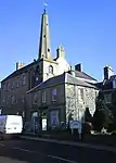 | |||
| 8 Sandyhill Road | 57°39′43″N 2°31′27″W | Category C(S) | 22082 | | |||
| 1 Back Path, Trevona | 57°39′48″N 2°31′18″W | Category C(S) | 21875 | | |||
| 3, 4, 5 Back Path and Garden Walls | 57°39′48″N 2°31′20″W | Category B | 21877 | | |||
| 8 Back Path and 18 High Street | 57°39′48″N 2°31′23″W | Category B | 21880 | | |||
| 8 And 9 Braeheads | 57°40′08″N 2°31′25″W | Category C(S) | 21892 | | |||
| 42, 44 Bridge Street | 57°39′51″N 2°31′16″W | Category C(S) | 21908 | | |||
| 17 Campbell Street | 57°40′08″N 2°31′42″W | Category C(S) | 21918 | | |||
| 9 Carmelite Street | 57°39′54″N 2°31′16″W | Category B | 21929 | | |||
| 41, 43 Castle Street | 57°40′02″N 2°31′26″W | Category C(S) | 21944 | | |||
| 83 Castle Street Old Brewery | 57°40′10″N 2°31′27″W | Category B | 21952 | | |||
| 6 Castle Street | 57°40′02″N 2°31′26″W | Category B | 21954 | | |||
| Beechgrove, (Former Ord Church Of Scotland) and War Memorial | 57°36′47″N 2°37′57″W | Category C(S) | 3047 | | |||
| Eagles Gate Lodge, Gatepiers and Quadrant Walls | 57°38′36″N 2°33′07″W | Category C(S) | 3048 | | |||
| Inchdrewer Castle | 57°38′06″N 2°34′40″W | Category A | 3049 | 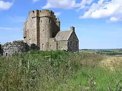 | |||
| Lower Inchdrewer | 57°38′19″N 2°34′26″W | Category B | 3051 | | |||
| Seafield Street, Kingswell Nursery School | 57°40′02″N 2°31′45″W | Category C(S) | 22097 | | |||
| 7 St Catherine Street | 57°40′04″N 2°31′29″W | Category B | 22101 | | |||
| 11 St Catherine Street | 57°40′04″N 2°31′31″W | Category C(S) | 22103 | | |||
| 8,10 Strait Path | 57°39′53″N 2°31′21″W | Category C(S) | 22108 | | |||
| 3 Church Street | 57°39′55″N 2°31′11″W | Category C(S) | 21970 | | |||
| 1 Clunie Street | 57°40′07″N 2°31′27″W | Category C(S) | 21972 | | |||
| 5 Clunie Street, Royston | 57°40′07″N 2°31′28″W | Category B | 21974 | | |||
| 6 Deveronside, 30A, 32A High Shore | 57°39′58″N 2°31′15″W | Category C(S) | 21980 |  | |||
| 7, 8 Deveronside, Ship Inn | 57°39′59″N 2°31′15″W | Category C(S) | 21981 | | |||
| Duff House, Fife Gates | 57°39′27″N 2°31′32″W | Category B | 21986 | | |||
| Duff House Icehouse | 57°39′16″N 2°31′45″W | Category C(S) | 21987 | 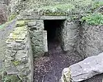 | |||
| 1 Fife Street | 57°40′04″N 2°31′33″W | Category B | 21990 | | |||
| 5, 7 Fife Street | 57°40′05″N 2°31′33″W | Category C(S) | 21992 | | |||
| 16 Fife Street and 21 Clunie Street | 57°40′07″N 2°31′32″W | Category C(S) | 21995 | | |||
| High Shore, Old St Mary's Burial Ground and Railings | 57°39′55″N 2°31′14″W | Category A | 22003 | | |||
| 21 High Shore, Shore House and Garden Walls | 57°39′57″N 2°31′16″W | Category C(S) | 22010 | | |||
| 39 High Street | 57°39′50″N 2°31′25″W | Category B | 22020 | | |||
| High Street, St Brandon's Close | 57°39′49″N 2°31′22″W | Category B | 22025 | | |||
| Low Street, Collie Lodge with Lamp Standards | 57°39′46″N 2°31′21″W | Category B | 22038 | | |||
| 4, 4A Low Street | 57°39′47″N 2°31′17″W | Category B | 22054 | | |||
| 36, 38 Low Street and 2 Carmelite Street | 57°39′52″N 2°31′17″W | Category B | 22064 | | |||
| 8 Old Castlegate, St Ninians and Garden Walls | 57°39′55″N 2°31′22″W | Category B | 22070 | | |||
| 9 Boyndie Street, Boyndie House | 57°39′54″N 2°31′26″W | Category B | 21884 | | |||
| 13 Boyndie Street | 57°39′54″N 2°31′28″W | Category B | 21886 | | |||
| 49, 51, 53 Bridge Street | 57°39′50″N 2°31′16″W | Category B | 21901 | | |||
| 11 Campbell Street | 57°40′09″N 2°31′41″W | Category C(S) | 21915 | | |||
| 15 Campbell Street | 57°40′08″N 2°31′41″W | Category C(S) | 21917 | | |||
| 1, 1A Carmelite Street | 57°39′53″N 2°31′17″W | Category C(S) | 21927 | | |||
| 16, 18 Carmelite Street | 57°39′53″N 2°31′15″W | Category B | 21932 | | |||
| 39 Castle Street, Winston House | 57°40′02″N 2°31′26″W | Category C(S) | 21943 | | |||
| 49, 51 Castle Street | 57°40′04″N 2°31′26″W | Category C(S) | 21946 | | |||
| 12, 14, 16 Castle Street Elm Bank | 57°39′57″N 2°31′23″W | Category C(S) | 21956 | | |||
| 14, 15 Sandyhill Road | 57°39′41″N 2°31′29″W | Category C(S) | 22087 | | |||
| Seafield Street, Mansefield | 57°40′01″N 2°31′31″W | Category C(S) | 22094 | | |||
| St Catherine Street, Jail Walls | 57°40′04″N 2°31′34″W | Category C(S) | 22104 | | |||
| 2 Water Path, Ingleneuk House Garden Walls and Garden Summer House | 57°39′55″N 2°31′18″W | Category A | 22111 | | |||
| 66, 66A Castle Street | 57°40′05″N 2°31′25″W | Category C(S) | 21962 | | |||
| 86 Castle Street | 57°40′08″N 2°31′25″W | Category B | 21967 | | |||
| 94 Castle Street and Rear Garden Wall | 57°40′10″N 2°31′25″W | Category C(S) | 21968 | | |||
| Church Street, House incorporated into Banff Tyre Service Premises | 57°39′54″N 2°31′06″W | Category C(S) | 21971 | | |||
| 7 Coldhome Street, Chapelhome including Garden Wall | 57°40′07″N 2°31′39″W | Category C(S) | 21979 | | |||
| 5 George Street | 57°40′05″N 2°31′22″W | Category C(S) | 22000 | | |||
| 5 High Street | 57°39′47″N 2°31′25″W | Category B | 22017 | | |||
| 33, 35 High Street | 57°39′50″N 2°31′25″W | Category B | 22019 | | |||
| 41, 43, 45, 47 High Street and Rear Garden Walls | 57°39′50″N 2°31′25″W | Category B | 22021 | | |||
| High Street, St Brandon's and Garden Walls | 57°39′49″N 2°31′22″W | Category B | 22027 | | |||
| 23, 25, 27 Low Street | 57°39′50″N 2°31′19″W | Category B | 22043 | | |||
| 55, 57, 59 Low Street | 57°39′53″N 2°31′19″W | Category B | 22050 | | |||
| Low Street, Biggar Fountain | 57°39′53″N 2°31′19″W | Category B | 22051 | | |||
| 5 Old Castlegate | 57°39′55″N 2°31′23″W | Category C(S) | 22066 | | |||
| 14 Old Castlegate and Garden Walls | 57°39′55″N 2°31′22″W | Category B | 22071 | | |||
| 1 Old Market Place, Front Wall and Gatepiers | 57°39′53″N 2°31′08″W | Category B | 22073 | | |||
| 9 Old Market Place | 57°39′54″N 2°31′06″W | Category B | 22075 | | |||
| 11 Old Market Place | 57°39′53″N 2°31′05″W | Category C(S) | 22076 | | |||
| Quayside, Banff Harbour and Pillbox | 57°40′12″N 2°31′24″W | Category A | 22077 | | |||
| 2 Back Path | 57°39′48″N 2°31′18″W | Category C(S) | 21876 | | |||
| 7 Bridge Street | 57°39′51″N 2°31′09″W | Category C(S) | 21896 | | |||
| 38, 40 Bridge Street | 57°39′51″N 2°31′15″W | Category C(S) | 21907 | | |||
| 1 Campbell Street | 57°40′11″N 2°31′39″W | Category C(S) | 21910 | | |||
| 5 Campbell Street | 57°40′11″N 2°31′40″W | Category C(S) | 21912 | | |||
| 4 Campbell Street | 57°40′11″N 2°31′38″W | Category C(S) | 21920 | | |||
| 12 Campbell Street | 57°40′09″N 2°31′39″W | Category C(S) | 21924 | | |||
| Castle Street, Manse Of Trinity and Alvah | 57°39′58″N 2°31′26″W | Category C(S) | 21937 | | |||
| 31, 33, 35 Castle Street and 2 Seafield Street, Town Hall | 57°40′00″N 2°31′26″W | Category A | 21941 | | |||
| 53, 55 Castle Street | 57°40′05″N 2°31′26″W | Category C(S) | 21947 | | |||
| 57, 59 Castle Street | 57°40′05″N 2°31′26″W | Category C(S) | 21948 | | |||
| 77 Castle Street | 57°40′07″N 2°31′26″W | Category B | 21950 | | |||
| Sandyhills Dovecote | 57°39′27″N 2°32′04″W | Category B | 6661 | | |||
| 22 Seafield Street, Chattonville | 57°40′00″N 2°31′31″W | Category B | 22096 | | |||
| 5 St Catherine Street | 57°40′04″N 2°31′29″W | Category B | 22100 | | |||
| 9 St Catherine Street | 57°40′04″N 2°31′30″W | Category B | 22102 | | |||
| 78 Castle Street | 57°40′07″N 2°31′25″W | Category B | 21966 | | |||
| 3 Fife Street | 57°40′05″N 2°31′33″W | Category B | 21991 | | |||
| 5 High Shore, Market Arms | 57°39′54″N 2°31′16″W | Category B | 22006 | | |||
| 11 High Shore | 57°39′55″N 2°31′16″W | Category B | 22008 | | |||
| High Street, St Andrew's Episcopal Church and Front Railings | 57°39′50″N 2°31′23″W | Category B | 22028 | | |||
| High Street, St Mary's Church Of Scotland | 57°39′47″N 2°31′23″W | Category B | 22029 | 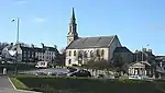 | |||
| 24 High Street, Oakbank | 57°39′50″N 2°31′23″W | Category C(S) | 22031 | | |||
| 32 High Street, County Hotel | 57°39′52″N 2°31′23″W | Category B | 22033 | | |||
| 9, 11, 13 Low Street | 57°39′49″N 2°31′19″W | Category B | 22041 | | |||
| 6 Old Castlegate | 57°39′55″N 2°31′22″W | Category B | 22069 | | |||
| 3, 4 Sandyhill Road, Seafield Hotel | 57°39′44″N 2°31′27″W | Category B | 22080 | | |||
| 10 Sandyhill Road | 57°39′42″N 2°31′28″W | Category C(S) | 22084 | | |||
| 1 Braeheads | 57°40′05″N 2°31′22″W | Category C(S) | 21889 | | |||
| Bridge Road, Bridge Gates House | 57°39′47″N 2°30′54″W | Category B | 21894 | | |||
| 2 Campbell Street | 57°40′11″N 2°31′38″W | Category C(S) | 21919 | | |||
| 10 Campbell Street | 57°40′10″N 2°31′39″W | Category C(S) | 21923 | | |||
| 19 Castle Street | 57°39′56″N 2°31′26″W | Category C(S) | 21934 | | |||
| Castle Street, Banff Castle, with Flanking Pavilions, Well and Old Castle Walls | 57°40′00″N 2°31′20″W | Category A | 21957 | 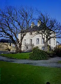 | |||
| Castle Street, Banff Castle Gate Lodges Gatepiers and Gates | 57°39′59″N 2°31′24″W | Category B | 21959 | | |||
| Manse Of Ord, Strathord | 57°36′52″N 2°38′01″W | Category C(S) | 6660 | | |||
| The Wrack, former Industrial Building | 57°38′57″N 2°32′20″W | Category C(S) | 6663 | | |||
| Scotstown, Banff Links, former Store Building | 57°40′09″N 2°32′37″W | Category C(S) | 47126 | | |||
| 18 Sandyhill Road and Rear Yard Wall | 57°39′40″N 2°31′31″W | Category C(S) | 22089 | | |||
| 21 Seafield Street, Cape House | 57°40′01″N 2°31′33″W | Category B | 22095 | | |||
| 9 Strait Path, The Broken Fiddle | 57°39′53″N 2°31′21″W | Category C(S) | 22106 |  | |||
| 6 Strait Path | 57°39′53″N 2°31′21″W | Category B | 22107 | | |||
| 76 Castle Street | 57°40′07″N 2°31′25″W | Category B | 21965 | | |||
| 23, 25 Clunie Street | 57°40′07″N 2°31′34″W | Category C(S) | 21976 | | |||
| 10 Deveronside | 57°40′00″N 2°31′15″W | Category C(S) | 21982 | | |||
| 16 High Shore | 57°39′56″N 2°31′15″W | Category B | 22013 | | |||
| 1 High Street | 57°39′46″N 2°31′25″W | Category B | 22015 | | |||
| 77, 79, 81 High Street, Forbes House | 57°39′53″N 2°31′25″W | Category B | 22022 | | |||
| Institution Terrace, Banff Primary School (former Banff Academy) with Lamp Standards | 57°39′46″N 2°31′28″W | Category A | 22035 | | |||
| Low Street, Former New Market Archway | 57°39′53″N 2°31′18″W | Category B | 22052 | | |||
| 30 Low Street, Carmelite House and Front Garden Wall | 57°39′51″N 2°31′17″W | Category B | 22060 | | |||
| 7 Back Path | 57°39′48″N 2°31′22″W | Category B | 21879 | | |||
| Bellevue Road, St Ann's Hill Garden Walls and Gatepiers | 57°39′42″N 2°31′34″W | Category B | 21882 | | |||
| 11 Boyndie Street, Banff Town and Country Club and Enclosing Walls | 57°39′54″N 2°31′27″W | Category A | 21885 | | |||
| 2 Braeheads | 57°40′05″N 2°31′22″W | Category C(S) | 21890 | | |||
| 1, 3, 5 Bridge Street | 57°39′51″N 2°31′08″W | Category C(S) | 21895 | | |||
| 2, 4 and 6 Bridge Street | 57°39′52″N 2°31′08″W | Category B | 21902 | | |||
| 7 Campbell Street | 57°40′10″N 2°31′40″W | Category C(S) | 21913 | | |||
| 16 Campbell Street | 57°40′09″N 2°31′40″W | Category C(S) | 21925 | | |||
| 18 Campbell Street | 57°40′08″N 2°31′40″W | Category C(S) | 21926 | | |||
| 2 Castle Lane | 57°39′56″N 2°31′23″W | Category B | 21933 | | |||
| Castle Street Trinity and Alvah Church Halls | 57°39′57″N 2°31′27″W | Category C(S) | 21936 | | |||
| 61, 63 Castle Street | 57°40′05″N 2°31′26″W | Category C(S) | 21949 | | |||
| Sandyhill Road, Our Lady of Mount Carmel RC Church | 57°39′39″N 2°31′34″W | Category B | 22090 | | |||
| Seafield Street, Ymca Hall | 57°40′01″N 2°31′28″W | Category C(S) | 22092 | | |||
| 72, 74 Castle Street | 57°40′06″N 2°31′25″W | Category C(S) | 21964 | | |||
| 3 Clunie Street | 57°40′07″N 2°31′27″W | Category C(S) | 21973 | | |||
| 12 Deveronside and Garden Walls | 57°40′01″N 2°31′15″W | Category B | 21984 | | |||
| 2 George Street | 57°40′04″N 2°31′24″W | Category C(S) | 21997 | | |||
| 4 George Street | 57°40′04″N 2°31′23″W | Category C(S) | 21999 | | |||
| Harbour Place, Old Customs House | 57°40′06″N 2°31′21″W | Category C(S) | 22002 | | |||
| 9 High Shore, Fernlee and Garden Walls | 57°39′55″N 2°31′17″W | Category B | 22007 | | |||
| 12 High Shore | 57°39′55″N 2°31′15″W | Category C(S) | 22011 | | |||
| High Shore, Gordons Granaries | 57°39′56″N 2°31′14″W | Category B | 22014 | | |||
| High Street, St Mary's Church Hall | 57°39′47″N 2°31′23″W | Category C(S) | 22023 | | |||
| 2 Institution Terrace | 57°39′47″N 2°31′27″W | Category B | 22037 | | |||
| 3, 5, 7 Low Street | 57°39′48″N 2°31′19″W | Category B | 22040 | | |||
| 29 Low Street, Bank of Scotland | 57°39′50″N 2°31′19″W | Category B | 22044 | | |||
| 35, 37, 41 Low Street | 57°39′51″N 2°31′20″W | Category B | 22046 | | |||
| 53 Low Street, Tolbooth Hotel and Old Jail | 57°39′53″N 2°31′20″W | Category B | 22049 |  | |||
| 2 Old Market Place, Panton House | 57°39′50″N 2°31′10″W | Category B | 22074 | | |||
| 7 Quayside | 57°40′09″N 2°31′23″W | Category C(S) | 22078 | | |||
| 9 Sandyhill Road | 57°39′43″N 2°31′28″W | Category C(S) | 22083 | | |||
| Bellevue Road, Bellevue With Garden Walls, Gates and Gatepiers | 57°39′40″N 2°31′33″W | Category B | 21881 | | |||
| 10 Boyndie Street | 57°39′53″N 2°31′28″W | Category C(S) | 21888 | | |||
| 4 Braeheads, St John's Masonic Hall including Boundary Walls | 57°40′06″N 2°31′23″W | Category C(S) | 21891 | | |||
| 9 Bridge Street | 57°39′51″N 2°31′09″W | Category C(S) | 21897 | | |||
| 46 Bridge Street | 57°39′51″N 2°31′16″W | Category C(S) | 21909 | | |||
| 3 Campbell Street | 57°40′11″N 2°31′39″W | Category C(S) | 21911 | | |||
| 6 Campbell Street | 57°40′10″N 2°31′39″W | Category C(S) | 21921 | | |||
| 8 Campbell Street | 57°40′10″N 2°31′39″W | Category C(S) | 21922 | | |||
| 23, 25 Castle Street | 57°39′59″N 2°31′26″W | Category B | 21938 | | |||
| 79, 81 Castle Street | 57°40′07″N 2°31′26″W | Category C(S) | 21951 | | |||
| 8, 10 Castle Street | 57°39′55″N 2°31′24″W | Category B | 21955 | | |||
| Sandyhill Road, Rc Presbytery | 57°39′39″N 2°31′34″W | Category C(S) | 22091 | | |||
| 3 St Catherine Street | 57°40′04″N 2°31′28″W | Category B | 22099 | | |||
| Water Path, Path House and Path Cottage | 57°39′56″N 2°31′21″W | Category B | 22109 | | |||
| Castle Street, War Memorial | 57°40′01″N 2°31′25″W | Category B | 21960 | | |||
| 96 Castle Street, Railway Inn | 57°40′10″N 2°31′25″W | Category B | 21969 | 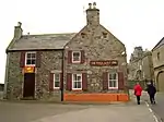 | |||
| 3 High Shore | 57°39′54″N 2°31′16″W | Category B | 22005 | | |||
| 14 High Shore | 57°39′55″N 2°31′15″W | Category B | 22012 | | |||
| 3 High Street | 57°39′47″N 2°31′25″W | Category B | 22016 | | |||
| 2 Low Street | 57°39′46″N 2°31′17″W | Category B | 22053 | | |||
| 24 And 26 Low Street and 55 Bridge Street | 57°39′50″N 2°31′17″W | Category C(S) | 22058 | | |||
| 32 Low Street | 57°39′51″N 2°31′17″W | Category C(S) | 22061 | | |||
| Low Street, Tolbooth Steeple | 57°39′52″N 2°31′17″W | Category A | 22062 | | |||
| 2 Old Castlegate and Rear Garden Wall | 57°39′54″N 2°31′23″W | Category B | 22068 | | |||
| Quayside, Warehouse | 57°40′10″N 2°31′24″W | Category C(S) | 22079 | | |||
| 5, 7, 7A Boyndie Street | 57°39′54″N 2°31′26″W | Category B | 21883 | | |||
| Bridge Of Banff over River Deveron | 57°39′46″N 2°30′48″W | Category A | 21893 | 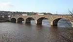 | |||
| 39 Bridge Street | 57°39′50″N 2°31′15″W | Category C(S) | 21899 | | |||
| 10 Bridge Street, Royal Oak Hotel | 57°39′51″N 2°31′11″W | Category C(S) | 21904 | | |||
| 28, 30, 32 Bridge Street | 57°39′51″N 2°31′14″W | Category C(S) | 21905 | | |||
| 36 Bridge Street | 57°39′51″N 2°31′14″W | Category B | 21906 | | |||
| 9 Campbell Street | 57°40′10″N 2°31′40″W | Category C(S) | 21914 | | |||
| 4, 6 Carmelite Street | 57°39′53″N 2°31′17″W | Category B | 21930 | | |||
| 10 Carmelite Street, Former Post Office | 57°39′53″N 2°31′16″W | Category B | 21931 | | |||
| Castle Street, Trinity and Alvah Church, Church Of Scotland | 57°39′57″N 2°31′26″W | Category B | 21935 | | |||
| 27, 27A Castle Street | 57°39′59″N 2°31′26″W | Category C(S) | 21939 | | |||
| 4 Castle Street | 57°40′07″N 2°31′26″W | Category B | 21953 | | |||
| Castle Street, Banff Castle Enclosing Walls surrounding Policies | 57°40′00″N 2°31′21″W | Category B | 21958 | | |||
| Inverboyndie, Jandar and Brandon View with Garden Walls | 57°40′07″N 2°33′22″W | Category C(S) | 3050 | |
Key
The scheme for classifying buildings in Scotland is:
- Category A: "buildings of national or international importance, either architectural or historic; or fine, little-altered examples of some particular period, style or building type."[1]
- Category B: "buildings of regional or more than local importance; or major examples of some particular period, style or building type, which may have been altered."[1]
- Category C: "buildings of local importance; lesser examples of any period, style, or building type, as originally constructed or moderately altered; and simple traditional buildings which group well with other listed buildings."[1]
In March 2016 there were 47,288 listed buildings in Scotland. Of these, 8% were Category A, and 50% were Category B, with the remaining 42% being Category C.[2]
Notes
- Sometimes known as OSGB36, the grid reference (where provided) is based on the British national grid reference system used by the Ordnance Survey.
• "Guide to National Grid". Ordnance Survey. Retrieved 2007-12-12.
• "Get-a-map". Ordnance Survey. Retrieved 2007-12-17. - Historic Environment Scotland assign a unique alphanumeric identifier to each designated site in Scotland, for listed buildings this always begins with "LB", for example "LB12345".
References
- All entries, addresses and coordinates are based on data from Historic Scotland. This data falls under the Open Government Licence
- "What is Listing?". Historic Environment Scotland. Retrieved 29 May 2018.
- Scotland's Historic Environment Audit 2016 (PDF). Historic Environment Scotland and the Built Environment Forum Scotland. pp. 15–16. Retrieved 29 May 2018.
This article is issued from Wikipedia. The text is licensed under Creative Commons - Attribution - Sharealike. Additional terms may apply for the media files.