List of listed buildings in Cambusnethan, North Lanarkshire
List
| Name | Location | Date Listed | Grid Ref. [note 1] | Geo-coordinates | Notes | LB Number [note 2] | Image |
|---|---|---|---|---|---|---|---|
| Wishaw, Netherton, Kirkhill Road, St Michael's Churchyard, Enclosure And Mausolea | 55°45′50″N 3°57′56″W | Category B | 64 |  | |||
| Newmains, 144 And 144A Manse Road Including Gatepiers | 55°46′54″N 3°53′04″W | Category C(S) | 47981 | | |||
| Wishaw, Garrion Bridge, Garrionhurst | 55°44′14″N 3°55′17″W | Category C(S) | 47987 | | |||
| Wishaw, Garrion Bridge, 1 And 2 Millfield Cottage | 55°44′19″N 3°55′20″W | Category C(S) | 47988 | | |||
| Allanton, Old Mill Road, Allanton Mill | 55°48′21″N 3°49′48″W | Category C(S) | 47976 | | |||
| Bonkle, Church Road, Bonkle Parish Church (Church Of Scotland) Including Church Hall And Gatepiers | 55°47′33″N 3°51′23″W | Category B | 47979 | Apr2006.jpg.webp) | |||
| Morningside Chapel, 322 And 324 Morningside Road, Former School | 55°46′13″N 3°51′35″W | Category C(S) | 50123 | | |||
| Bonkle, Murdostoun Road, Murdostoun Bridge | 55°47′35″N 3°51′33″W | Category B | 669 | | |||
| Auchterhead Muir, Covenanters Monument, Darmead-Lin | 55°46′43″N 3°45′13″W | Category B | 671 | | |||
| Bonkle, 1 Church Road | 55°47′31″N 3°51′28″W | Category C(S) | 47980 | | |||
| Overtown, Main Street, Overtown Parish Church (Church Of Scotland) | 55°45′11″N 3°54′42″W | Category C(S) | 47984 | 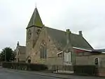 | |||
| Wishaw, Netherton, Kirkhill Road, Kirkhill House | 55°45′59″N 3°57′35″W | Category C(S) | 47990 | | |||
| Newmains, Church Avenue, Coltness Memorial Church (Church Of Scotland) | 55°46′51″N 3°53′03″W | Category B | 673 | 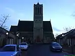 | |||
| Overtown, 148 Main Street, Overtown Parish Church Manse Including Boundary Wall | 55°45′11″N 3°54′43″W | Category C(S) | 47985 | | |||
| Stane, 19 Main Street Including Boundary Wall | 55°48′55″N 3°47′16″W | Category C(S) | 47986 | | |||
| Wishaw, Garrion Bridge, Millfield House Including Boundary Wall | 55°44′20″N 3°55′19″W | Category C(S) | 47989 | | |||
| Wishaw, Netherton, Kirkhill Road, St Michael's Graveyard, Belhaven And Stenton Mausoleum | 55°45′50″N 3°57′56″W | Category B | 672 | 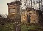 | |||
| Bonkle, 3, 5 And 7 Allanton Road | 55°47′33″N 3°51′29″W | Category C(S) | 666 | | |||
| Wishaw, Garrion Bridge, Garrion Tower | 55°44′16″N 3°55′05″W | Category B | 670 | | |||
| Bonkle, Allanton Road, Woodypoint Estate, Bridge | 55°47′40″N 3°51′05″W | Category C(S) | 47977 | | |||
| Bonkle, 251 Bonkle Road, Auchter House Including Gatepiers And Railings | 55°47′25″N 3°51′44″W | Category C(S) | 47978 | | |||
| Wishaw, Castlehill Road, Cambusnethan House | 55°45′20″N 3°56′40″W | Category A | 47593 | | |||
| Allanton, Allanton Road, Brucefield Farm, Allanton Well | 55°47′52″N 3°50′56″W | Category C(S) | 6450 | | |||
| Wishaw, Castlehill Road, Cambusnethan House, The Coach House | 55°45′24″N 3°56′50″W | Category B | 689 | | |||
| Bonkle, 9 Allanton Road | 55°47′34″N 3°51′28″W | Category C(S) | 667 | | |||
| Newmains, Manse Road, Newmains Police Station Including Boundary Wall And Railings | 55°46′59″N 3°52′40″W | Category B | 47982 | | |||
| Bonkle, 2 Allanton Road | 55°47′32″N 3°51′27″W | Category C(S) | 691 | |
Key
The scheme for classifying buildings in Scotland is:
- Category A: "buildings of national or international importance, either architectural or historic; or fine, little-altered examples of some particular period, style or building type."[1]
- Category B: "buildings of regional or more than local importance; or major examples of some particular period, style or building type, which may have been altered."[1]
- Category C: "buildings of local importance; lesser examples of any period, style, or building type, as originally constructed or moderately altered; and simple traditional buildings which group well with other listed buildings."[1]
In March 2016 there were 47,288 listed buildings in Scotland. Of these, 8% were Category A, and 50% were Category B, with the remaining 42% being Category C.[2]
Notes
- Sometimes known as OSGB36, the grid reference (where provided) is based on the British national grid reference system used by the Ordnance Survey.
• "Guide to National Grid". Ordnance Survey. Retrieved 2007-12-12.
• "Get-a-map". Ordnance Survey. Retrieved 2007-12-17. - Historic Environment Scotland assign a unique alphanumeric identifier to each designated site in Scotland, for listed buildings this always begins with "LB", for example "LB12345".
References
- All entries, addresses and coordinates are based on data from Historic Scotland. This data falls under the Open Government Licence
- "What is Listing?". Historic Environment Scotland. Retrieved 29 May 2018.
- Scotland's Historic Environment Audit 2016 (PDF). Historic Environment Scotland and the Built Environment Forum Scotland. pp. 15–16. Retrieved 29 May 2018.
This article is issued from Wikipedia. The text is licensed under Creative Commons - Attribution - Sharealike. Additional terms may apply for the media files.