List of listed buildings in Contin, Highland
List
| Name | Location | Date Listed | Grid Ref. [note 1] | Geo-coordinates | Notes | LB Number [note 2] | Image |
|---|---|---|---|---|---|---|---|
| Coul House Hotel Formerly Coul House | 57°34′17″N 4°34′21″W | Category A | 1769 | 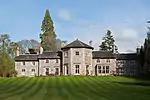 | |||
| Kinlochluichart Old Manse And Steading | 57°37′19″N 4°49′10″W | Category C(S) | 1775 |  | |||
| Strathconon Church Of Scotland Parish Church | 57°32′33″N 4°51′19″W | Category B | 1781 | .jpg.webp) | |||
| Contin Parish Church (Church Of Scotland) And Burial Ground | 57°33′56″N 4°34′57″W | Category B | 1790 | 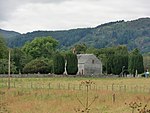 | |||
| Coul House Hotel West Lodge | 57°34′08″N 4°34′47″W | Category C(S) | 1770 | | |||
| Jamestown, Former Free Church Manse | 57°34′25″N 4°32′42″W | Category B | 1772 | | |||
| Kinellan Farm | 57°34′55″N 4°33′09″W | Category C(S) | 1773 | .jpg.webp) | |||
| Scatwell House Community Centre Cottages And Walled Garden | 57°33′53″N 4°40′42″W | Category C(S) | 1778 | 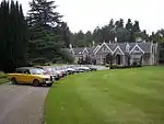 | |||
| Conon Valley Hydro Electric Scheme, Vaich Dam, Including Spillway Towers And Weir | 57°44′02″N 4°46′46″W | Category C(S) | 51707 | .jpg.webp) | |||
| Contin Manse (Church Of Scotland) | 57°33′52″N 4°34′50″W | Category C(S) | 1768 | 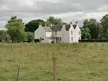 | |||
| Kinlochluichart Church Of Scotland And Burial Ground | 57°37′21″N 4°49′14″W | Category B | 1774 | .jpg.webp) | |||
| Lochroisque Old Lodge | 57°34′42″N 5°05′46″W | Category C(S) | 1777 | | |||
| Conon Valley, Hydro Electric Scheme, Achanalt Power Station And Dam, Including Fish Pass | 57°36′57″N 4°49′58″W | Category C(S) | 51705 | | |||
| Strathconon Former Church Of Scotland Manse | 57°32′36″N 4°51′15″W | Category B | 1782 | | |||
| Strathconon Bridge Over River Meig At Bridgend | 57°33′12″N 4°48′18″W | Category B | 1780 | | |||
| Achnasheen. Ledgowan Bridge Over River Bran | 57°34′40″N 5°04′54″W | Category B | 1788 | .jpg.webp) | |||
| Contin Bridge Over River Black Water | 57°34′25″N 4°35′12″W | Category A | 1789 | .jpg.webp) | |||
| Conon Valley Hydro Electric Scheme, Loch Glascarnoch Dam | 57°41′45″N 4°46′39″W | Category B | 51706 | .jpg.webp) | |||
| Mains Of Coul | 57°34′12″N 4°34′22″W | Category B | 1771 | 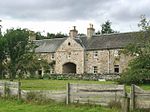 | |||
| Scatwell House Main Gate Lodge. Gate Piers And Gates | 57°33′46″N 4°40′31″W | Category C(S) | 1779 | |
Key
The scheme for classifying buildings in Scotland is:
- Category A: "buildings of national or international importance, either architectural or historic; or fine, little-altered examples of some particular period, style or building type."[1]
- Category B: "buildings of regional or more than local importance; or major examples of some particular period, style or building type, which may have been altered."[1]
- Category C: "buildings of local importance; lesser examples of any period, style, or building type, as originally constructed or moderately altered; and simple traditional buildings which group well with other listed buildings."[1]
In March 2016 there were 47,288 listed buildings in Scotland. Of these, 8% were Category A, and 50% were Category B, with the remaining 42% being Category C.[2]
See also
Notes
- Sometimes known as OSGB36, the grid reference (where provided) is based on the British national grid reference system used by the Ordnance Survey.
• "Guide to National Grid". Ordnance Survey. Retrieved 2007-12-12.
• "Get-a-map". Ordnance Survey. Retrieved 2007-12-17. - Historic Environment Scotland assign a unique alphanumeric identifier to each designated site in Scotland, for listed buildings this always begins with "LB", for example "LB12345".
References
- All entries, addresses and coordinates are based on data from Historic Scotland. This data falls under the Open Government Licence
- "What is Listing?". Historic Environment Scotland. Retrieved 29 May 2018.
- Scotland's Historic Environment Audit 2016 (PDF). Historic Environment Scotland and the Built Environment Forum Scotland. pp. 15–16. Retrieved 29 May 2018.
This article is issued from Wikipedia. The text is licensed under Creative Commons - Attribution - Sharealike. Additional terms may apply for the media files.