List of listed buildings in Cromarty, Highland
List
| Name | Location | Date Listed | Grid Ref. [note 1] | Geo-coordinates | Notes | LB Number [note 2] | Image |
|---|---|---|---|---|---|---|---|
| George Street, Mary Ness | 57°40′57″N 4°02′12″W | Category B | 23678 |  | |||
| George Street, Lighthouse And Lighthouse Keeper's House | 57°40′59″N 4°02′11″W | Category A | 23680 | | |||
| 11 And 13 High Street | 57°40′52″N 4°02′03″W | Category C(S) | 23684 | | |||
| Marine Terrace, Hemp Works | 57°40′52″N 4°02′16″W | Category B | 23702 | | |||
| The Paye, Gaelic Chapel Graveyard And Graveyard Wall | 57°40′45″N 4°02′00″W | Category B | 23706 | | |||
| Braehead Primary School And School House | 57°40′55″N 4°02′03″W | Category B | 23559 | | |||
| Church Street, St Regulus' Episcopal Church | 57°40′49″N 4°01′54″W | Category C(S) | 23581 | | |||
| Church Street East Parish Churchyard And Churchyard Walls | 57°40′44″N 4°01′44″W | Category B | 23596 | | |||
| Denny Road, Hadley | 57°40′47″N 4°02′11″W | Category C(S) | 23611 | | |||
| Fishertown, 67 Big Vennel | 57°40′48″N 4°01′48″W | Category C(S) | 23631 | | |||
| Fishertown, 58 Gordon's Lane | 57°40′50″N 4°01′51″W | Category C(S) | 23646 | | |||
| Fishertown, 86 Little Vennel | 57°40′48″N 4°01′47″W | Category C(S) | 23653 | | |||
| Fishertown, 89 Little Vennel | 57°40′48″N 4°01′46″W | Category C(S) | 23656 | | |||
| 1 Allan Square And Bank Street, Lusaka | 57°40′54″N 4°02′10″W | Category C(S) | 23525 | | |||
| 8, 10 And 12 Bank Street | 57°40′52″N 4°02′07″W | Category C(S) | 23545 | | |||
| Cromarty House | 57°40′36″N 4°01′32″W | Category A | 1818 | | |||
| 2 Forsyth Place | 57°40′52″N 4°01′57″W | Category C(S) | 23673 | | |||
| 3 Forsyth Place | 57°40′52″N 4°01′57″W | Category C(S) | 23674 | | |||
| Cromarty Harbour | 57°40′58″N 4°02′19″W | Category A | 23700 | | |||
| 2 Barkly Street | 57°40′54″N 4°02′08″W | Category B | 23549 | | |||
| 4 Barkly Street | 57°40′54″N 4°02′08″W | Category B | 23550 | | |||
| 7 Braehead | 57°40′54″N 4°02′00″W | Category C(S) | 23556 | | |||
| Burnside Place, Old Brewery | 57°40′45″N 4°01′40″W | Category B | 23568 | | |||
| 5 Church Street | 57°40′51″N 4°01′57″W | Category B | 23574 | | |||
| 19 Church Street | 57°40′50″N 4°01′55″W | Category C(S) | 23579 | | |||
| Church Street, Drinking Fountain In Garden In Front Of Hugh Miller Institute | 57°40′49″N 4°01′53″W | Category C(S) | 23583 | | |||
| Church Street, Braefoot | 57°40′48″N 4°01′53″W | Category C(S) | 23584 | | |||
| Church Street, Hugh Miller's Cottage | 57°40′48″N 4°01′51″W | Category A | 23588 | 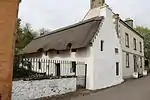 | |||
| Church Street, East Parish Church | 57°40′44″N 4°01′45″W | Category A | 23595 | 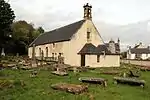 | |||
| 24 Church Street | 57°40′51″N 4°01′54″W | Category B | 23604 | | |||
| 1 And 5 Duke Street | 57°40′55″N 4°02′10″W | Category B | 23618 | | |||
| Fishertown, 70 Big Vennel | 57°40′48″N 4°01′47″W | Category C(S) | 23634 | | |||
| Fishertown, 35 Gordon's Lane | 57°40′51″N 4°01′51″W | Category B | 23644 | | |||
| Fishertown, 59 Gordon's Lane | 57°40′50″N 4°01′50″W | Category C(S) | 23647 | | |||
| Fishertown, 93 Little Vennel | 57°40′49″N 4°01′45″W | Category C(S) | 23657 | | |||
| Fishertown, 46 Seabank (Off Shore Street) | 57°40′52″N 4°01′53″W | Category C(S) | 23660 | | |||
| Allan Square And Bank Street, Sandstones | 57°40′54″N 4°02′10″W | Category C(S) | 23527 | | |||
| 6 And 8 Allan Square | 57°40′53″N 4°02′10″W | Category C(S) | 23533 | | |||
| 2 And 4 Allan Street | 57°40′53″N 4°02′10″W | Category C(S) | 23534 | | |||
| 29 Bank Street | 57°40′55″N 4°02′10″W | Category B | 23539 | | |||
| Bank Street, The Old Bank House | 57°40′54″N 4°02′11″W | Category B | 23541 | | |||
| Cromarty Mains Farmhouse | 57°40′16″N 4°01′25″W | Category B | 1821 | | |||
| George Street, Frith View | 57°40′57″N 4°02′12″W | Category B | 23676 | | |||
| High Street, Forsyth House (Former Manse) Gates And Gatepiers | 57°40′53″N 4°02′00″W | Category B | 23681 | | |||
| 3 And 5 High Street | 57°40′52″N 4°02′02″W | Category C(S) | 23682 | | |||
| 7 And 9 High Street | 57°40′52″N 4°02′02″W | Category C(S) | 23683 | | |||
| Cromarty, High Street Townlands Barn | 57°40′50″N 4°02′07″W | Category A | 23695 | 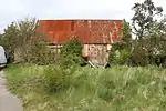 | |||
| The Paye, Hugh Miller Monument | 57°40′46″N 4°01′58″W | Category B | 23707 | | |||
| Fishermen's Bothy Forsyth Place | 57°40′54″N 4°01′55″W | Category C(S) | 23709 | | |||
| 4 And 6 Bank Street | 57°40′52″N 4°02′06″W | Category C(S) | 23546 | | |||
| Burnside Place, Church Hall | 57°40′44″N 4°01′41″W | Category C(S) | 23569 | | |||
| 9 Church Street | 57°40′51″N 4°01′56″W | Category B | 23576 | | |||
| Church Street, Mercat Cross (Within Grounds Of Courthouse) | 57°40′48″N 4°01′52″W | Category B | 23586 | | |||
| Church Street, The Retreat | 57°40′47″N 4°01′48″W | Category B | 23590 | | |||
| 47 Church Street, Albion House | 57°40′46″N 4°01′47″W | Category B | 23592 | | |||
| Church Street, Arms Cottage | 57°40′48″N 4°01′50″W | Category C(S) | 23602 | | |||
| 16 Church Street, Struy House | 57°40′51″N 4°01′56″W | Category C(S) | 23607 | | |||
| 2 Denny Road | 57°40′47″N 4°02′11″W | Category C(S) | 23612 | | |||
| 3 Denny Road (D Mcclean) | 57°40′46″N 4°02′10″W | Category C(S) | 23613 | | |||
| Fishertown, 81 Big Vennel | 57°40′49″N 4°01′47″W | Category C(S) | 23632 | | |||
| Fishertown, 66 Big Vennel | 57°40′48″N 4°01′48″W | Category B | 23635 | | |||
| Fishertown, 87 Little Vennel | 57°40′48″N 4°01′47″W | Category C(S) | 23654 | | |||
| Fishertown, 92 Little Vennel | 57°40′48″N 4°01′44″W | Category C(S) | 23658 | | |||
| Allan Square, Bank Cottage | 57°40′54″N 4°02′12″W | Category C(S) | 23529 | | |||
| 5 Allan Square | 57°40′54″N 4°02′12″W | Category C(S) | 23530 | | |||
| 12 Allan Square | 57°40′52″N 4°02′12″W | Category B | 23531 | | |||
| Bank Street, Ardyne | 57°40′53″N 4°02′08″W | Category B | 23536 | | |||
| 27 Bank Street, Beach Brae | 57°40′55″N 4°02′10″W | Category B | 23538 | | |||
| 20 Bank Street | 57°40′53″N 4°02′08″W | Category C(S) | 23542 | | |||
| Fishertown, 4 Shore Street | 57°40′53″N 4°01′56″W | Category C(S) | 23663 | | |||
| Fishertown, Shore Street Seabank House, Garden Walls And Gatepiers | 57°40′52″N 4°01′52″W | Category B | 23667 | | |||
| Fishertown, 56 Shore Street | 57°40′51″N 4°01′49″W | Category C(S) | 23669 | | |||
| 37 High Street (Off High Street) | 57°40′51″N 4°02′08″W | Category B | 23689 | | |||
| High Street, Laurel House | 57°40′51″N 4°02′09″W | Category B | 23690 | | |||
| High Street, "Rurki" | 57°40′49″N 4°02′15″W | Category C(S) | 23692 | | |||
| High Street "Mizpah" | 57°40′48″N 4°02′14″W | Category C(S) | 23694 | | |||
| 8 And 10 High Street | 57°40′51″N 4°02′01″W | Category C(S) | 23698 | | |||
| 2 And 4 High Street | 57°40′51″N 4°01′59″W | Category B | 23699 | | |||
| 5 And 6 Miller Lane | 57°40′50″N 4°01′48″W | Category C(S) | 23704 | | |||
| The Paye, Paye House (Corner The Paye And Church Street | 57°40′48″N 4°01′50″W | Category B | 23705 | | |||
| 6 And 8 Barkly Street, The Moorings | 57°40′55″N 4°02′07″W | Category C(S) | 23551 | | |||
| 2 Braehead | 57°40′53″N 4°02′00″W | Category B | 23553 | | |||
| 3 Braehead | 57°40′53″N 4°02′00″W | Category B | 23554 | | |||
| Braehead, Alvara And Speybank Villa | 57°40′58″N 4°02′08″W | Category B | 23562 | | |||
| 11 Church Street | 57°40′51″N 4°01′56″W | Category C(S) | 23577 | | |||
| 21 Church Street | 57°40′50″N 4°01′55″W | Category C(S) | 23580 | | |||
| 49 Church Street | 57°40′46″N 4°01′46″W | Category B | 23593 | | |||
| Church Street, St Anne's | 57°40′47″N 4°01′45″W | Category B | 23600 | | |||
| 18 Church Street, Victoria House | 57°40′51″N 4°01′55″W | Category C(S) | 23606 | | |||
| Fishertown, 78 Big Vennel | 57°40′49″N 4°01′46″W | Category C(S) | 23633 | | |||
| Fishertown 34 Gordon's Lane | 57°40′51″N 4°01′52″W | Category B | 23640 | | |||
| Fishertown 38 Gordon's Lane ("Shoreline") | 57°40′52″N 4°01′51″W | Category C(S) | 23642 | | |||
| Fishertown, 88 Little Vennel | 57°40′48″N 4°01′46″W | Category C(S) | 23655 | | |||
| 33 Bank Street | 57°40′56″N 4°02′13″W | Category C(S) | 23540 | | |||
| 16 And 18 Bank Street | 57°40′52″N 4°02′08″W | Category B | 23543 | | |||
| Fishertown, 6 Shore Street | 57°40′53″N 4°01′55″W | Category C(S) | 23664 | | |||
| Fishertown, Shore Street Moonfleet | 57°40′52″N 4°01′53″W | Category C(S) | 23666 | | |||
| Fishertown, Adjoining Russell House: In Shore Street | 57°40′51″N 4°01′50″W | Category C(S) | 23668 | | |||
| George Street, The Cliff | 57°40′57″N 4°02′13″W | Category B | 23677 | | |||
| George Street, Reay House | 57°40′58″N 4°02′10″W | Category B | 23679 | | |||
| 25 And 27 High Street | 57°40′51″N 4°02′06″W | Category B | 23687 | | |||
| Roseville, 29 High Street | 57°40′51″N 4°02′07″W | Category B | 23688 | | |||
| Marine Terrace, The Royal Hotel | 57°40′56″N 4°02′16″W | Category C(S) | 23701 | | |||
| High Street/Forsyth Place, K6 Telephone Kiosk | 57°40′52″N 4°01′59″W | Category B | 23708 | | |||
| 8 Braehead | 57°40′54″N 4°02′01″W | Category C(S) | 23557 | | |||
| 9 Braehead | 57°40′54″N 4°02′01″W | Category C(S) | 23558 | | |||
| Burnside Place, Burnside Cottage | 57°40′46″N 4°01′39″W | Category B | 23567 | | |||
| Causeway, The Gardener's House And Garden Walls | 57°40′43″N 4°01′33″W | Category A | 23570 | 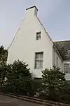 | |||
| 13 And 15 Church Street | 57°40′50″N 4°01′55″W | Category C(S) | 23578 | | |||
| Church Street Bellevue | 57°40′47″N 4°01′50″W | Category B | 23589 | | |||
| 14 Church Street | 57°40′51″N 4°01′56″W | Category C(S) | 23608 | | |||
| 10 Church Street | 57°40′51″N 4°01′56″W | Category C(S) | 23609 | | |||
| 2 Church Street | 57°40′52″N 4°01′57″W | Category C(S) | 23610 | | |||
| 15 Denny Road | 57°40′45″N 4°02′10″W | Category C(S) | 23615 | | |||
| 7 Duke Street | 57°40′55″N 4°02′10″W | Category B | 23619 | | |||
| 11 Duke Street | 57°40′56″N 4°02′09″W | Category B | 23621 | | |||
| 6 Duke Street | 57°40′56″N 4°02′11″W | Category B | 23628 | | |||
| 2 Duke Street (And Bank Street) Kintail Cottage | 57°40′56″N 4°02′12″W | Category B | 23629 | | |||
| Fishertown, 28/29 Gordon's Lane | 57°40′50″N 4°01′53″W | Category C(S) | 23637 | | |||
| Fishertown, 62 Gordon's Lane | 57°40′50″N 4°01′49″W | Category C(S) | 23649 | | |||
| 3 Allan Square | 57°40′54″N 4°02′10″W | Category B | 23526 | | |||
| 14 Forsyth Place | 57°40′52″N 4°01′55″W | Category B | 23675 | | |||
| 19 And 21 High Street | 57°40′51″N 4°02′05″W | Category C(S) | 23685 | | |||
| 23 High Street | 57°40′51″N 4°02′06″W | Category B | 23686 | | |||
| High Street "Fuinary" | 57°40′48″N 4°02′15″W | Category B | 23693 | | |||
| High Street, Bank Of Scotland | 57°40′51″N 4°02′05″W | Category B | 23696 | | |||
| 3 And 3A Barkly Street | 57°40′55″N 4°02′08″W | Category C(S) | 23548 | | |||
| Braehead, Servants' House To Barkly House | 57°40′57″N 4°02′06″W | Category B | 23560 | | |||
| The Causeway, The Kennels | 57°40′43″N 4°01′31″W | Category B | 23571 | | |||
| Church Street Hugh Miller Institute | 57°40′49″N 4°01′54″W | Category C(S) | 23582 | | |||
| Church Street, Court House, Prison And Gatepiers | 57°40′48″N 4°01′52″W | Category A | 23585 | 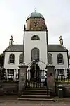 | |||
| Church Street, Wellington House | 57°40′46″N 4°01′48″W | Category B | 23591 | | |||
| 51 Church Street, Buzancy | 57°40′45″N 4°01′45″W | Category B | 23594 | | |||
| Church Street, Lydia Cottage | 57°40′48″N 4°01′49″W | Category C(S) | 23601 | | |||
| Church Street, Cromarty Arms | 57°40′49″N 4°01′51″W | Category C(S) | 23603 | | |||
| 15 Duke Street (The Haven) | 57°40′57″N 4°02′09″W | Category B | 23624 | | |||
| 12 Duke Street | 57°40′56″N 4°02′10″W | Category B | 23626 | | |||
| Fishertown, Big Vennel The Creel | 57°40′48″N 4°01′49″W | Category C(S) | 23630 | | |||
| Fishertown, 31 Gordon's Lane | 57°40′50″N 4°01′52″W | Category C(S) | 23638 | | |||
| Fishertown, 60 Gordon's Lane | 57°40′50″N 4°01′50″W | Category C(S) | 23648 | | |||
| Fishertown 63 Gordon's Lane | 57°40′50″N 4°01′49″W | Category C(S) | 23650 | | |||
| Fishertown, 49 Seabank (Now In Grounds Of Seabank House) | 57°40′51″N 4°01′52″W | Category C(S) | 23662 | | |||
| 10 Allan Square Ivydene | 57°40′53″N 4°02′11″W | Category B | 23532 | | |||
| Bank Street, Mount Eagle | 57°40′52″N 4°02′05″W | Category B | 23535 | | |||
| Bank Street, Allanbank House, And 1 Barkly Street | 57°40′54″N 4°02′08″W | Category B | 23537 | | |||
| Cromarty House Servants' Tunnel | 57°40′37″N 4°01′29″W | Category B | 1819 | | |||
| Fishertown, Shore Street Stornoway House | 57°40′52″N 4°01′54″W | Category C(S) | 23665 | | |||
| Fishertown, 99 Shore Street | 57°40′47″N 4°01′42″W | Category B | 23671 | | |||
| 1 Forsyth Place (Gable And Shop Entrance To Church Street) | 57°40′52″N 4°01′58″W | Category B | 23672 | | |||
| 1 Miller Lane | 57°40′49″N 4°01′50″W | Category C(S) | 23703 | | |||
| Barkly Street, Fire Station | 57°40′55″N 4°02′08″W | Category C(S) | 23547 | | |||
| 1 Braehead | 57°40′53″N 4°01′58″W | Category B | 23552 | | |||
| Braehead, Barkly House | 57°40′57″N 4°02′07″W | Category B | 23561 | | |||
| The Causeway, Clunes Cottage | 57°40′44″N 4°01′30″W | Category B | 23572 | | |||
| The Causeway, Clunes House | 57°40′45″N 4°01′31″W | Category B | 23573 | | |||
| 7 Church Street | 57°40′51″N 4°01′57″W | Category B | 23575 | | |||
| Church Street, Miller House | 57°40′48″N 4°01′51″W | Category A | 23587 | | |||
| 50 Church Street, The Cobbles | 57°40′46″N 4°01′45″W | Category C(S) | 23597 | | |||
| 60 Church Street | 57°40′46″N 4°01′45″W | Category C(S) | 23599 | | |||
| 22 Church Street | 57°40′51″N 4°01′55″W | Category B | 23605 | | |||
| 13 Denny Road (Miss Cameron) | 57°40′46″N 4°02′10″W | Category C(S) | 23614 | | |||
| 14 Duke Street | 57°40′57″N 4°02′09″W | Category B | 23625 | | |||
| Fishertown, 27 Gordon's Lane | 57°40′50″N 4°01′53″W | Category C(S) | 23636 | | |||
| Fishertown, 32 Gordon's Lane | 57°40′50″N 4°01′52″W | Category C(S) | 23639 | | |||
| Fishertown, Russell House 55 Gordon's Lane | 57°40′51″N 4°01′50″W | Category B | 23645 | | |||
| 14 Bank Street | 57°40′52″N 4°02′08″W | Category C(S) | 23544 | | |||
| Fishertown, Shore Street Weatherglass House | 57°40′50″N 4°01′47″W | Category C(S) | 23670 | | |||
| High Street, Denoon Villa (Corner High Street/Denoon Place) | 57°40′50″N 4°02′11″W | Category C(S) | 23691 | | |||
| 12 High Street, Sidney House | 57°40′51″N 4°02′02″W | Category C(S) | 23697 | | |||
| 5 Braehead | 57°40′54″N 4°02′00″W | Category C(S) | 23555 | | |||
| Braehead, Braehead Cottage | 57°40′54″N 4°01′59″W | Category C(S) | 23563 | | |||
| Braehead, Icehouse | 57°40′36″N 4°01′32″W | Category C(S) | 23564 | | |||
| Burnside Place, Burnside | 57°40′45″N 4°01′43″W | Category B | 23565 | | |||
| Burnside Place, Farndale | 57°40′45″N 4°01′41″W | Category B | 23566 | | |||
| 62 Church Street | 57°40′46″N 4°01′45″W | Category B | 23598 | | |||
| Denny Road, Lodge To Cromarty House And Gatepiers | 57°40′32″N 4°02′10″W | Category C(S) | 23616 | | |||
| 1914-1918 And 1939-45 War Memorial, Off Denny Road | 57°40′44″N 4°02′05″W | Category C(S) | 23617 | | |||
| 9 Duke Street, York House | 57°40′56″N 4°02′09″W | Category B | 23620 | | |||
| 13 Duke Street | 57°40′56″N 4°02′08″W | Category B | 23622 | | |||
| 18 Duke Street | 57°40′57″N 4°02′08″W | Category B | 23623 | | |||
| 8 Duke Street | 57°40′56″N 4°02′11″W | Category B | 23627 | | |||
| Fishertown, 36 Gordon's Lane | 57°40′51″N 4°01′51″W | Category C(S) | 23641 | | |||
| Fishertown, 39 Gordon's Lane | 57°40′51″N 4°01′51″W | Category C(S) | 23643 | | |||
| Fishertown, 65 Gordon's Lane | 57°40′48″N 4°01′49″W | Category C(S) | 23651 | | |||
| Fishertown, 64 Gordon's Lane | 57°40′50″N 4°01′48″W | Category C(S) | 23652 | | |||
| Fishertown, 45 Seabank (Off Shore Street) | 57°40′52″N 4°01′53″W | Category C(S) | 23659 | | |||
| Fishertown, 47 Seabank | 57°40′51″N 4°01′52″W | Category C(S) | 23661 | | |||
| Allan Square Bank Cottage, Gatepiers | 57°40′54″N 4°02′12″W | Category B | 23528 | | |||
| Cromarty House Stables | 57°40′31″N 4°01′27″W | Category A | 1820 | |
Key
The scheme for classifying buildings in Scotland is:
- Category A: "buildings of national or international importance, either architectural or historic; or fine, little-altered examples of some particular period, style or building type."[1]
- Category B: "buildings of regional or more than local importance; or major examples of some particular period, style or building type, which may have been altered."[1]
- Category C: "buildings of local importance; lesser examples of any period, style, or building type, as originally constructed or moderately altered; and simple traditional buildings which group well with other listed buildings."[1]
In March 2016 there were 47,288 listed buildings in Scotland. Of these, 8% were Category A, and 50% were Category B, with the remaining 42% being Category C.[2]
See also
Notes
- Sometimes known as OSGB36, the grid reference (where provided) is based on the British national grid reference system used by the Ordnance Survey.
• "Guide to National Grid". Ordnance Survey. Retrieved 2007-12-12.
• "Get-a-map". Ordnance Survey. Retrieved 2007-12-17. - Historic Environment Scotland assign a unique alphanumeric identifier to each designated site in Scotland, for listed buildings this always begins with "LB", for example "LB12345".
References
- All entries, addresses and coordinates are based on data from Historic Scotland. This data falls under the Open Government Licence
- "What is Listing?". Historic Environment Scotland. Retrieved 29 May 2018.
- Scotland's Historic Environment Audit 2016 (PDF). Historic Environment Scotland and the Built Environment Forum Scotland. pp. 15–16. Retrieved 29 May 2018.
This article is issued from Wikipedia. The text is licensed under Creative Commons - Attribution - Sharealike. Additional terms may apply for the media files.