List of listed buildings in Cumbernauld, North Lanarkshire
List
| Name | Location | Date Listed | Grid Ref. [note 1] | Geo-coordinates | Notes | LB Number [note 2] | Image |
|---|---|---|---|---|---|---|---|
| Cumbernauld Parish Kirk | 55°57′40″N 3°58′52″W | Category B | 24068 |  | |||
| "The Masonic Arms", 62 Main Street | 55°57′44″N 3°58′34″W | Category B | 24081 | | |||
| Dullatur Village Prospect Road Dunluce | 55°58′03″N 4°00′46″W | Category A | 1062 | | |||
| Dullatur Village, Victoria Road, Norwood And Hillcroft | 55°58′07″N 4°00′29″W | Category B | 1070 | | |||
| Dullatur Village 1-11 (Inclusive Nos) Victoria Terrace | 55°58′10″N 4°00′41″W | Category B | 1071 | | |||
| Afton Road, Kildrum Primary School, Including Kildrum Nursery Centre | 55°57′15″N 3°58′17″W | Category B | 47351 | | |||
| 29 Main Street, Cumbernauld | 55°57′44″N 3°58′30″W | Category C(S) | 24072 | | |||
| 34 Main Street, Cumbernauld | 55°57′45″N 3°58′30″W | Category C(S) | 24076 | | |||
| 36 Main Street | 55°57′44″N 3°58′31″W | Category C(S) | 24077 | | |||
| 70 Main Street | 55°57′44″N 3°58′35″W | Category C(S) | 24083 | | |||
| Fannyside Toll | 55°56′25″N 3°54′59″W | Category C(S) | 1072 | | |||
| Cumbernauld, 23-27, Odd Numbers, Main Street | 55°57′44″N 3°58′28″W | Category C(S) | 45780 | | |||
| St Mungo's Road, St Mungo's Church (Church Of Scotland), Including Halls, Steel Cross | 55°56′50″N 3°59′33″W | Category B | 46977 | | |||
| Dowanfield Road, Our Lady's High School With Former Janitors Houses And Technical Block | 55°56′37″N 4°00′10″W | Category B | 47481 | | |||
| "The Cross Keys", 43 Main Street | 55°57′43″N 3°58′31″W | Category C(S) | 24075 | | |||
| Nos. 18 And 20 The Wynd | 55°57′47″N 3°58′30″W | Category C(S) | 24085 | | |||
| Cumbernauld House - Sundial | 55°57′38″N 3°58′03″W | Category B | 24087 | 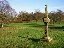 | |||
| Auchenkilns Bridge, Over Luggie Water | 55°55′49″N 4°00′10″W | Category C(S) | 24090 | | |||
| Castlecary, Putlock Bridge, Former Road Bridge Over Red Burn | 55°58′53″N 3°56′43″W | Category C(S) | 6682 | 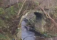 | |||
| Over Croy Farm, Croy Village | 55°57′36″N 4°02′44″W | Category B | 1074 | | |||
| 35 Main Street | 55°57′44″N 3°58′30″W | Category C(S) | 24073 | | |||
| 72-80 Main St | 55°57′43″N 3°58′37″W | Category C(S) | 24084 | | |||
| Cumbernauld House | 55°57′37″N 3°58′07″W | Category A | 24086 | | |||
| Cumbernauld House - Doocot | 55°57′48″N 3°57′40″W | Category B | 24088 | 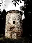 | |||
| Mainhead Farmhouse And Attached Out-Buildings | 55°57′59″N 3°58′35″W | Category B | 24089 | | |||
| Fannyside Mill | 55°56′18″N 3°54′24″W | Category B | 1073 | | |||
| Dullatur Village, Victoria Road, Stanley House, And Glenside | 55°58′05″N 4°00′27″W | Category C(S) | 121 | | |||
| Parish Kirk Manse | 55°57′40″N 3°58′55″W | Category C(S) | 24069 | | |||
| Banknock, Wyndford Lock, Lock Keeper's Cottage | 55°59′11″N 3°57′49″W | Category B | 1075 | | |||
| 37-39 Main Street | 55°57′44″N 3°58′31″W | Category C(S) | 24074 | | |||
| 60 Main Street | 55°57′44″N 3°58′34″W | Category C(S) | 24080 | | |||
| Kyle Road, Kildrum, Sacred Heart Roman Catholic Church And Presbytery | 55°57′06″N 3°58′35″W | Category A | 24091 | 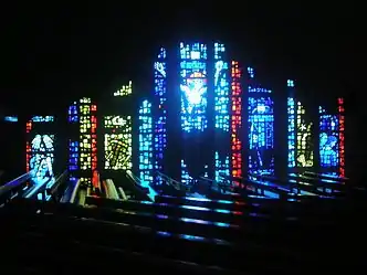 | |||
| Dullatur Village, Prospect Road, Woodend | 55°58′04″N 4°00′44″W | Category A | 1063 | | |||
| 40-54 Main St | 55°57′45″N 3°58′32″W | Category C(S) | 24078 | | |||
| 56 Main Street | 55°57′44″N 3°58′33″W | Category B | 24079 | | |||
| 64-68 Main Street | 55°57′44″N 3°58′35″W | Category C(S) | 24082 | | |||
| Auchenbee Farm | 55°57′30″N 4°01′33″W | Category B | 6449 | | |||
| Dullatur Village, Victoria Road, Craigard | 55°58′05″N 4°00′30″W | Category B | 1039 | | |||
| North Carbrain Road, Cumbernauld College, Including Walls And Railings | 55°56′46″N 3°59′22″W | Category B | 47482 | | |||
| Former U.F. Kirk, The Wynd | 55°57′48″N 3°58′32″W | Category C(S) | 24070 | | |||
| The Spur Inn, Cumbernauld | 55°57′44″N 3°58′26″W | Category C(S) | 24071 | | |||
| Luggiebank, Roadbridge Over Luggie Water | 55°55′58″N 3°58′53″W | Category B | 46705 | | |||
| Clouden Road, Kildrum Parish Church (Church Of Scotland), Including Hall And Manse | 55°56′58″N 3°58′36″W | Category B | 47480 | |
Key
The scheme for classifying buildings in Scotland is:
- Category A: "buildings of national or international importance, either architectural or historic; or fine, little-altered examples of some particular period, style or building type."[1]
- Category B: "buildings of regional or more than local importance; or major examples of some particular period, style or building type, which may have been altered."[1]
- Category C: "buildings of local importance; lesser examples of any period, style, or building type, as originally constructed or moderately altered; and simple traditional buildings which group well with other listed buildings."[1]
In March 2016 there were 47,288 listed buildings in Scotland. Of these, 8% were Category A, and 50% were Category B, with the remaining 42% being Category C.[2]
Notes
- Sometimes known as OSGB36, the grid reference (where provided) is based on the British national grid reference system used by the Ordnance Survey.
• "Guide to National Grid". Ordnance Survey. Retrieved 2007-12-12.
• "Get-a-map". Ordnance Survey. Retrieved 2007-12-17. - Historic Environment Scotland assign a unique alphanumeric identifier to each designated site in Scotland, for listed buildings this always begins with "LB", for example "LB12345".
References
- All entries, addresses and coordinates are based on data from Historic Scotland. This data falls under the Open Government Licence
- "What is Listing?". Historic Environment Scotland. Retrieved 29 May 2018.
- Scotland's Historic Environment Audit 2016 (PDF). Historic Environment Scotland and the Built Environment Forum Scotland. pp. 15–16. Retrieved 29 May 2018.
This article is issued from Wikipedia. The text is licensed under Creative Commons - Attribution - Sharealike. Additional terms may apply for the media files.