List of listed buildings in Dalkeith, Midlothian
List
| Name | Location | Date Listed | Grid Ref. [note 1] | Geo-coordinates | Notes | LB Number [note 2] | Image |
|---|---|---|---|---|---|---|---|
| 72-76 (Even Nos) St Andrew Street | 55°53′47″N 3°03′56″W | Category C(S) | 24467 |  | |||
| 1 Eskbank Terrace, Tor Lodge | 55°53′17″N 3°04′34″W | Category C(S) | 24372 | | |||
| 10-14 (Even Nos) Glebe Street, Lanfine And Glebe Lodge With Boundary Wall | 55°53′42″N 3°04′18″W | Category C(S) | 24374 | | |||
| High Street, Duke's Gate, Town Lodge And Estate Walls | 55°53′52″N 3°03′58″W | Category B | 24376 | 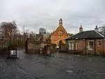 | |||
| 89 And 91 High Street | 55°53′41″N 3°04′11″W | Category C(S) | 24391 | 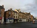 | |||
| 93 High Street And 1 Edinburgh Road | 55°53′41″N 3°04′11″W | Category B | 24392 | 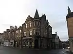 | |||
| 105-111 (Odd Nos) High Street | 55°53′42″N 3°04′09″W | Category B | 24395 | | |||
| 115 And 117 High Street, And 3-6 (Inclusive Nos) Brunton's Close | 55°53′42″N 3°04′09″W | Category C(S) | 24397 | | |||
| 131 And 133 High Street | 55°53′45″N 3°04′06″W | Category C(S) | 24400 | | |||
| 116-120 (Even Nos) High Street | 55°53′39″N 3°04′07″W | Category B | 24412 | | |||
| 8-11 (Inclusive Nos) London Road | 55°53′32″N 3°04′04″W | Category C(S) | 24436 | | |||
| 2 Lothian Street, With Outbuildings | 55°53′32″N 3°04′08″W | Category B | 24439 | | |||
| 4 Lothian Street And 2-6 (Even Nos) Newmills Road, Former Co-Operative Buildings | 55°53′34″N 3°04′07″W | Category C(S) | 24442 | | |||
| Old Edinburgh Road, West Church (Church Of Scotland), With Boundary Walls | 55°53′39″N 3°04′24″W | Category B | 24457 | 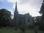 | |||
| 18 Park Road, Meadowbank, With Boundary Walls And Gatepiers | 55°53′22″N 3°04′29″W | Category C(S) | 24463 | | |||
| 19 Abbey Road, Hobart House, With Boundary Walls, Gatepiers And Gates | 55°53′12″N 3°04′29″W | Category B | 24321 | | |||
| 71 And 73 Bonnyrigg Road, Cragdale And Fernlea | 55°53′01″N 3°05′14″W | Category C(S) | 24329 | | |||
| Cemetery Road, Water Tower | 55°53′29″N 3°04′37″W | Category B | 24338 | 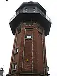 | |||
| 8 Lothian Road, Fairfield House, With Boundary Walls And Outbuildings | 55°53′30″N 3°04′10″W | Category B | 24340 | | |||
| 5 Edinburgh Road | 55°53′41″N 3°04′12″W | Category B | 24351 | | |||
| 3 And 5 Eskbank Road | 55°53′34″N 3°04′20″W | Category B | 24357 | | |||
| 7 And 9 Eskbank Road | 55°53′34″N 3°04′20″W | Category B | 24358 | | |||
| Dalkeith Park, Montagu Bridge Including Cauld | 9 March 1992 | 55°54′06″N 3°04′02″W | Category A | 1440 | 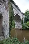 | ||
| Dalkeith Park, Stables And Coach House | 9 March 1992 | 55°54′05″N 3°03′41″W | Category A | 1442 | | ||
| Lugton Walled Gardens, Head Gardener's House | 9 March 1992 | 55°53′55″N 3°04′32″W | Category B | 1433 | | ||
| 1-9 (Inclusive Nos) Thornybank Cottages And Gateway To Thornybank Steading | 9 March 1992 | 55°53′52″N 3°03′12″W | Category C(S) | 1434 | | ||
| Thornybank House | 9 March 1992 | 55°53′52″N 3°03′08″W | Category C(S) | 1435 | | ||
| Dalkeith Park, Laundry House | 9 March 1992 | 55°54′10″N 3°03′39″W | Category B | 1439 | 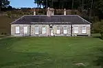 | ||
| 23, 25 And 27 South Street | 55°53′37″N 3°04′09″W | Category B | 24472 | | |||
| Station Road, Former Eskbank And Dalkeith Station, Foot Bridge, Road Bridge And Platforms | 55°53′18″N 3°04′57″W | Category B | 24473 | | |||
| 44 Eskbank Road, Woodville | 55°53′22″N 3°04′46″W | Category B | 24369 | | |||
| 13 And 15 Glebe Street, Glebe Bank House, With Garden And Boundary Walls | 55°53′43″N 3°04′20″W | Category B | 24373 | | |||
| 9-13 (Odd Nos) High Street | 55°53′36″N 3°04′20″W | Category C(S) | 24380 | 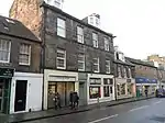 | |||
| 165-169 (Odd Nos) High Street | 55°53′49″N 3°04′02″W | Category B | 24404 | | |||
| 100 And 102 High Street, Clydesdale Bank | 55°53′40″N 3°04′11″W | Category B | 24408 | | |||
| 168-172 (Even Nos) High Street | 55°53′43″N 3°04′05″W | Category B | 24416 | | |||
| 196 And 198 High Street | 55°53′46″N 3°04′02″W | Category B | 24421 | | |||
| 212 And 214 High Street | 55°53′48″N 3°04′01″W | Category B | 24423 | | |||
| 9 Lasswade Road, Bernafay | 55°53′18″N 3°04′54″W | Category B | 24432 | | |||
| 1-5 (Inclusive Nos) London Road | 55°53′31″N 3°04′07″W | Category B | 24434 | | |||
| 6 London Road | 55°53′31″N 3°04′06″W | Category B | 24435 | | |||
| Old Edinburgh Road, New Burial Ground, Watch Tower | 55°53′38″N 3°04′21″W | Category B | 24456 | 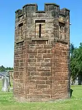 | |||
| 12 Old Edinburgh Road, West Church Manse | 55°53′37″N 3°04′24″W | Category B | 24458 | | |||
| 2 Bridgend, The Neuk, With Outbuildings | 55°53′49″N 3°04′24″W | Category C(S) | 24330 | | |||
| 4 Bridgend, Craigievar | 55°53′49″N 3°04′24″W | Category C(S) | 24331 | | |||
| 25 Croft Street | 55°53′32″N 3°04′17″W | Category C(S) | 24344 | | |||
| Edinburgh Road, Grannies Park, Dalkeith Mills | 55°53′46″N 3°04′24″W | Category B | 24347 | | |||
| Elmfield Court, Former Barracks | 55°53′35″N 3°04′02″W | Category C(S) | 24354 | | |||
| Eskbank Road, St David's Church, With Boundary Walls And Gatepiers | 55°53′27″N 3°04′32″W | Category A | 24355 | 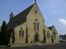 | |||
| Dalkeith Park, Conservatory | 9 March 1992 | 55°54′08″N 3°03′36″W | Category A | 1410 | | ||
| 22 Ironmills Road, Lade Cottage | 55°53′42″N 3°04′40″W | Category C(S) | 49659 | | |||
| 2 And 4 St Andrew Street, The Old Mealmarket Inn | 55°53′36″N 3°04′09″W | Category C(S) | 24465 | | |||
| 64-70 (Even Nos) St Andrew Street | 55°53′46″N 3°03′56″W | Category C(S) | 24466 | | |||
| 5 And 7 Station Road | 55°53′17″N 3°04′56″W | Category C(S) | 24474 | | |||
| Woodburn Road Gatepiers To Former Woodburn House Opposite Post Office | 55°53′36″N 3°03′28″W | Category B | 24478 | | |||
| 5 And 7 High Street | 55°53′36″N 3°04′20″W | Category C(S) | 24379 | 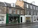 | |||
| 67-71 (Odd Nos) High Street | 55°53′40″N 3°04′14″W | Category B | 24385 | 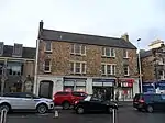 | |||
| 153 And 155 High Street | 55°53′47″N 3°04′03″W | Category C(S) | 24402 | | |||
| 122-126 High Street | 55°53′40″N 3°04′09″W | Category B | 24413 | | |||
| Ironmills Park, Ironmills, Miller's House | 55°53′31″N 3°04′45″W | Category B | 24428 | | |||
| 2B Lothian Street | 55°53′33″N 3°04′08″W | Category C(S) | 24440 | | |||
| 6 Newbattle Road, Appin Lodge | 55°53′16″N 3°04′46″W | Category B | 24448 | | |||
| 14 Newbattle Road, Greenend | 55°53′15″N 3°04′42″W | Category C(S) | 24450 | | |||
| Newmills Road, Dalkeith High School | 55°53′36″N 3°03′50″W | Category B | 24451 | | |||
| 9 Park Road, Roseneuk | 55°53′19″N 3°04′38″W | Category C(S) | 24459 | | |||
| 11 Park Road, Hollybush | 55°53′20″N 3°04′38″W | Category C(S) | 24460 | | |||
| 18 Ancrum Road, Dalriada House, With Boundary Walls And Gatepiers | 55°53′12″N 3°04′41″W | Category B | 24324 | | |||
| 51 And 53 Bonnyrigg Road | 55°53′04″N 3°05′09″W | Category C(S) | 24327 | | |||
| Cemetery Road, New Cemetery, Lodge, Gatepiers And Gates | 55°53′29″N 3°04′37″W | Category C(S) | 24337 | | |||
| 21 And 23 Croft Street | 55°53′33″N 3°04′18″W | Category C(S) | 24343 | | |||
| 27-35 (Odd Nos) Croft Street, Former Tannery | 55°53′32″N 3°04′16″W | Category B | 24345 | | |||
| Dalkeith Park, Dark Walk, Gateway And Walls | 9 March 1992 | 55°53′51″N 3°03′34″W | Category A | 1412 | | ||
| Dalkeith Park, Gamekeeper's House | 9 March 1992 | 55°54′06″N 3°03′22″W | Category B | 1413 | | ||
| Dalkeith Park, King's Gate, Walls And Lodge | 9 March 1992 | 55°53′51″N 3°05′09″W | Category A | 1437 | 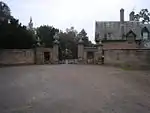 | ||
| Dalkeith Park, Laundry Bridge | 9 March 1992 | 55°54′10″N 3°03′36″W | Category B | 1438 | | ||
| 14 Park Road, Waverley Cottage, Including Boundary Walls, Gates, Gatepiers, Forecourt And Outbuilding | 55°53′19″N 3°04′35″W | Category C(S) | 49690 | | |||
| 4 Edinburgh Road | 55°53′41″N 3°04′10″W | Category C(S) | 24477 | | |||
| 53 Eskbank Road, Gilston Lodge, With Boundary Walls And Gatepiers | 55°53′22″N 3°04′42″W | Category C(S) | 24364 | | |||
| 40 Eskbank Road, Elm Lodge, With Boundary Walls And Gatepiers | 55°53′24″N 3°04′44″W | Category B | 24367 | | |||
| 46 Eskbank Road, Beechmohr, And 1 Avenue Road, Dunmohr, With Boundary Walls And Gatepiers | 55°53′21″N 3°04′48″W | Category C(S) | 24370 | | |||
| High Street, Old Kirk (Church Of Scotland, Formerly East Church (St Nicholas)), With Graveyard Walls And Watch House | 55°53′44″N 3°04′08″W | Category A | 24377 | 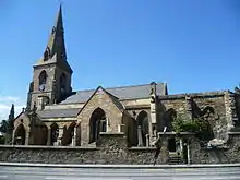 | |||
| 77 And 79 High Street | 55°53′40″N 3°04′13″W | Category C(S) | 24387 | | |||
| 95-99 (Odd Nos) High Street | 55°53′41″N 3°04′10″W | Category C(S) | 24393 | 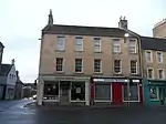 | |||
| 128-134 (Even Nos) High Street | 55°53′41″N 3°04′08″W | Category B | 24414 | | |||
| Ironmills Park, Pavilion | 55°53′38″N 3°04′44″W | Category B | 24430 | | |||
| 13 And 15 Lasswade Road, With Boundary Walls | 55°53′19″N 3°05′00″W | Category C(S) | 24433 | | |||
| 2-6 (Even Nos) Lothian Road | 55°53′31″N 3°04′10″W | Category B | 24438 | | |||
| 23 Newbattle Road | 55°53′14″N 3°04′33″W | Category C(S) | 24447 | | |||
| 8 Newbattle Road, Hazelbank | 55°53′16″N 3°04′45″W | Category B | 24449 | | |||
| 13 And 15 Park Road, The Lilacs And Ellon Cottage | 55°53′20″N 3°04′36″W | Category C(S) | 24461 | | |||
| 20 Ancrum Road And 24 Newbattle Road, Dunallan, With Boundary Walls, Gatepiers And Gates | 55°53′13″N 3°04′39″W | Category B | 24322 | | |||
| 55 And 57 Bonnyrigg Road, Pentland View And Beulah | 55°53′04″N 3°05′10″W | Category C(S) | 24328 | | |||
| 2-8 (Even Nos) Buccleuch Street, Municipal Buildings | 55°53′34″N 3°04′19″W | Category B | 24334 | | |||
| 20 Edinburgh Road , Airdene With Boundary Walls And Gatepiers | 55°53′45″N 3°04′14″W | Category B | 24353 | | |||
| 49 Eskbank Road, The Birks, With Boundary Walls And Gatepiers | 55°53′23″N 3°04′41″W | Category B | 24362 | | |||
| 2 And 4 Eskbank Road, Harrow Hotel | 55°53′35″N 3°04′22″W | Category C(S) | 24365 | | |||
| 14 Glenesk Crescent, Eskbank House, With Boundary Walls And Gatepiers | 55°53′25″N 3°04′47″W | Category A | 24375 | | |||
| 1 And 3 High Street, And 1 Old Edinburgh Road | 55°53′36″N 3°04′20″W | Category C(S) | 24378 | 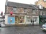 | |||
| 15 And 17 High Street | 55°53′37″N 3°04′20″W | Category C(S) | 24381 | 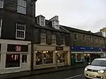 | |||
| 119 High Street | 55°53′43″N 3°04′09″W | Category C(S) | 24398 | | |||
| 135 And 137 High Street | 55°53′45″N 3°04′06″W | Category B | 24401 | | |||
| 177 High Street, Dalkeith Park House | 55°53′51″N 3°04′01″W | Category B | 24406 | 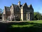 | |||
| 10 And 12 High Street | 55°53′36″N 3°04′18″W | Category B | 24407 | | |||
| 112 And 114 High Street | 55°53′40″N 3°04′09″W | Category B | 24411 | | |||
| 182 High Street, Cross Keys Hotel | 55°53′44″N 3°04′04″W | Category B | 24418 | | |||
| 200 High Street And 61 St Andrew Street, Corn Exchange | 55°53′46″N 3°04′00″W | Category A | 24422 | | |||
| 4A And 4B Lothian Street Including Courtyard And Range To E | 55°53′33″N 3°04′08″W | Category C(S) | 24441 | | |||
| 1 And 3 Musselburgh Road, With Outbuildings | 55°53′50″N 3°03′55″W | Category C(S) | 24445 | | |||
| 21 Newbattle Road, Orwell Bank | 55°53′14″N 3°04′34″W | Category C(S) | 24446 | | |||
| 2 Avenue Road, Strathesk, With Boundary Walls And Gatepiers | 55°53′22″N 3°04′48″W | Category B | 24325 | | |||
| 17 And 19 Croft Street | 55°53′33″N 3°04′18″W | Category C(S) | 24342 | | |||
| 10 Dalhousie Road, Parkend House | 55°53′16″N 3°04′52″W | Category C(S) | 24346 | | |||
| Edinburgh Road, Lugton Bridge | 55°53′48″N 3°04′25″W | Category B | 24349 | | |||
| 17 And 19 Eskbank Road | 55°53′34″N 3°04′21″W | Category C(S) | 24359 | | |||
| Gilmerton Road, Glenarch, Summerhouse | 9 March 1992 | 55°53′33″N 3°05′02″W | Category C(S) | 1443 | | ||
| Dalkeith Park, Hermitage | 9 March 1992 | 55°54′16″N 3°04′21″W | Category B | 1414 | | ||
| 129 High Street, Lodge Dalkeith Kilwinning No 10 (Masonic Lodge) | 55°53′46″N 3°04′09″W | Category B | 47371 | | |||
| 12 Park Road, Ardchattan Including Boundary Walls And Gatepiers | 55°53′19″N 3°04′35″W | Category C(S) | 49619 | | |||
| 84-90 (Even Nos) St Andrew Street | 55°53′48″N 3°03′55″W | Category C(S) | 24469 | | |||
| 13 Waverley Road, Glencairn | 55°53′20″N 3°04′26″W | Category B | 24475 | | |||
| 48 Eskbank Road, Langlands Lodge, With Boundary Walls And Gatepiers | 55°53′21″N 3°04′49″W | Category B | 24371 | | |||
| 41 High Street | 55°53′38″N 3°04′17″W | Category C(S) | 24383 | | |||
| 75 High Street | 55°53′40″N 3°04′13″W | Category B | 24386 | | |||
| 113 High Street, And 1A, 1B Brunton's Close | 55°53′42″N 3°04′08″W | Category B | 24396 | | |||
| 161 And 163 High Street | 55°53′47″N 3°04′03″W | Category B | 24403 | | |||
| 104 And 106 High Street | 55°53′39″N 3°04′09″W | Category B | 24409 | | |||
| 12 Melville Road, Linsandel House, With Outbuildings, Boundary Walls, Gates And Gatepiers | 55°53′22″N 3°04′53″W | Category A | 24443 | | |||
| Newmills Road, Dalkeith Lodge (Newbattle Abbey West Lodge), With Gateway And Adjoining Wall | 55°53′31″N 3°04′00″W | Category A | 24452 | 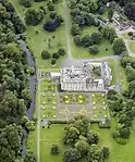 | |||
| Newmills Road, Newmills Bridge | 55°53′32″N 3°03′46″W | Category B | 24453 | | |||
| 22 Park Road, Stonefield With Boundary Wall And Gatepiers | 55°53′24″N 3°04′27″W | Category C(S) | 24464 | | |||
| 8 Bridgend, Rosecot, With Railings | 55°53′49″N 3°04′26″W | Category C(S) | 24333 | | |||
| 45 Buccleuch Street, Black Bull | 55°53′33″N 3°04′10″W | Category B | 24335 | | |||
| Cemetery Road, Bridge | 55°53′28″N 3°04′35″W | Category B | 24336 | | |||
| Croft Street, Fairfield House, Hot House | 55°53′31″N 3°04′10″W | Category A | 24339 | | |||
| 3 Edinburgh Road, Full Gospel Church | 55°53′41″N 3°04′11″W | Category C(S) | 24350 | | |||
| Eskbank Road, St John's And King's Park Church (Church Of Scotland), With Boundary Walls | 55°53′31″N 3°04′23″W | Category B | 24356 | 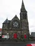 | |||
| Glenesk Railway Viaduct | 9 March 1992 | 55°53′33″N 3°04′58″W | Category A | 1445 | | ||
| Cowden Cleugh Cottage | 9 March 1992 | 55°53′59″N 3°02′20″W | Category B | 1409 | | ||
| Dalkeith Park, Dalkeith House, With Retaining Wall And Lamp Standards | 9 March 1992 | 55°53′59″N 3°04′04″W | Category A | 1411 | 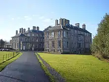 | ||
| Dalkeith Park, Icehouse | 9 March 1992 | 55°53′54″N 3°04′03″W | Category B | 1415 | 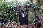 | ||
| Lugton Walled Gardens (Formerly To Dalkeith House) Including Upper Walled Garden, Lower Walled Garden, Boundary Wall To E And Lugton Brae Retaining Wall To E Of Main Entrance | 55°53′54″N 3°04′26″W | Category C(S) | 49624 | | |||
| 78-82 (Even Nos) St Andrew Street | 55°53′47″N 3°03′55″W | Category C(S) | 24468 | | |||
| 11 South Street | 55°53′38″N 3°04′11″W | Category B | 24470 | | |||
| 2 Edinburgh Road | 55°53′41″N 3°04′10″W | Category C(S) | 24476 | | |||
| 51 Eskbank Road, With Boundary Walls And Gatepiers | 55°53′23″N 3°04′42″W | Category C(S) | 24363 | | |||
| 38 Eskbank Road, With Boundary Walls And Gatepiers | 55°53′26″N 3°04′42″W | Category C(S) | 24366 | | |||
| 37 And 39 High Street | 55°53′38″N 3°04′18″W | Category C(S) | 24382 | 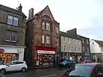 | |||
| 43 High Street | 55°53′39″N 3°04′17″W | Category C(S) | 24384 | | |||
| 81 High Street | 55°53′41″N 3°04′13″W | Category C(S) | 24388 | | |||
| 83 And 85 High Street | 55°53′40″N 3°04′12″W | Category B | 24389 | | |||
| 87 High Street | 55°53′41″N 3°04′12″W | Category C(S) | 24390 | | |||
| 101 And 103 High Street | 55°53′41″N 3°04′10″W | Category B | 24394 | | |||
| 175 High Street, Militia House | 55°53′50″N 3°04′01″W | Category C(S) | 24405 | 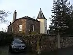 | |||
| 108 And 110 High Street | 55°53′40″N 3°04′09″W | Category C(S) | 24410 | | |||
| 140 And 142 High Street | 55°53′42″N 3°04′07″W | Category B | 24415 | | |||
| 176-180 (Even Nos) High Street, Dalkeith Tolbooth | 55°53′43″N 3°04′04″W | Category A | 24417 | 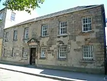 | |||
| 216 And 218 High Street | 55°53′48″N 3°04′01″W | Category C(S) | 24424 | | |||
| Ironmills Park, Ironmills, Cartshed Range | 55°53′32″N 3°04′43″W | Category B | 24426 | | |||
| Ironmills Park, Ironmills, Iron Mill | 55°53′30″N 3°04′45″W | Category B | 24427 | | |||
| Ironmills Park, Memorial Bridge | 55°53′30″N 3°04′41″W | Category B | 24429 | | |||
| 9 Lothian Bank, Mount Lothian, With Boundary Walls, Gatepiers And Lamp Standards | 55°53′09″N 3°04′45″W | Category C(S) | 24437 | | |||
| Musselburgh Road, New Cow Bridge | 55°53′49″N 3°03′30″W | Category B | 24444 | | |||
| Newmills Road, The Old Mill House (Formerly Newmills House) | 55°53′29″N 3°03′50″W | Category B | 24454 | | |||
| 27 Park Road | 55°53′26″N 3°04′30″W | Category C(S) | 24462 | | |||
| 6 Bridgend, Tower House | 55°53′49″N 3°04′25″W | Category C(S) | 24332 | | |||
| Croft Street, King's Park Primary School | 55°53′29″N 3°04′14″W | Category B | 24341 | | |||
| Edinburgh Road, Grannies Park, Former Skinnery | 55°53′45″N 3°04′20″W | Category C(S) | 24348 | | |||
| 47 Eskbank Road, Belmont, With Boundary Walls, Gates And Gatepiers And Former Coach House | 55°53′24″N 3°04′38″W | Category B | 24361 | | |||
| Dalkeith Park, St Mary's Episcopal Chapel, With Lamp Standard | 9 March 1992 | 55°53′53″N 3°03′55″W | Category A | 1441 | 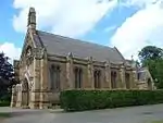 | ||
| Gilmerton Road, Glenarch, Lodge And Gatepiers | 9 March 1992 | 55°53′29″N 3°05′02″W | Category C(S) | 1444 | | ||
| 1 Lugton Brae, Greenacres | 9 March 1992 | 55°53′50″N 3°04′31″W | Category B | 1446 | | ||
| 17 Lugton Brae | 9 March 1992 | 55°53′51″N 3°04′40″W | Category C(S) | 1447 | | ||
| 6 Lugton Brae, Lugton House, With Boundary Walls And Railings | 9 March 1992 | 55°53′52″N 3°04′35″W | Category C(S) | 1432 | | ||
| Wester Cowden Farmhouse | 9 March 1992 | 55°53′36″N 3°02′22″W | Category C(S) | 1436 | | ||
| 21 South Street | 55°53′37″N 3°04′10″W | Category B | 24471 | | |||
| 42 Eskbank Road, Mayfield Lodge | 55°53′23″N 3°04′45″W | Category C(S) | 24368 | | |||
| 127 High Street, Birchlea | 55°53′45″N 3°04′10″W | Category B | 24399 | | |||
| 186 And 188 High Street, Masons Arms | 55°53′45″N 3°04′02″W | Category C(S) | 24419 | | |||
| 190-194 High Street | 55°53′45″N 3°04′02″W | Category C(S) | 24420 | | |||
| 228 And 230 High Street | 55°53′49″N 3°04′00″W | Category B | 24425 | | |||
| King's Park, War Memorial | 55°53′29″N 3°04′27″W | Category C(S) | 24431 | | |||
| 28 Newmills Road, Eskside House, With Outbuilding And Boundary Walls | 55°53′31″N 3°03′58″W | Category C(S) | 24455 | | |||
| 2 Ancrum Road, Greenore | 55°53′11″N 3°04′41″W | Category B | 24323 | | |||
| Bonnyrigg Road, Westfield Park, With Gates, Railings, Gatepiers And Boundary Walls | 55°53′15″N 3°04′53″W | Category B | 24326 | | |||
| 19 Edinburgh Road, With Boundary Walls And Gatepiers | 55°53′42″N 3°04′15″W | Category B | 24352 | | |||
| 19 Lugton Brae Old Parsonage, With Boundary Wall And Gatepiers | 9 March 1992 | 55°53′50″N 3°04′41″W | Category B | 1431 | |
Key
The scheme for classifying buildings in Scotland is:
- Category A: "buildings of national or international importance, either architectural or historic; or fine, little-altered examples of some particular period, style or building type."[1]
- Category B: "buildings of regional or more than local importance; or major examples of some particular period, style or building type, which may have been altered."[1]
- Category C: "buildings of local importance; lesser examples of any period, style, or building type, as originally constructed or moderately altered; and simple traditional buildings which group well with other listed buildings."[1]
In March 2016 there were 47,288 listed buildings in Scotland. Of these, 8% were Category A, and 50% were Category B, with the remaining 42% being Category C.[2]
Notes
- Sometimes known as OSGB36, the grid reference (where provided) is based on the British national grid reference system used by the Ordnance Survey.
• "Guide to National Grid". Ordnance Survey. Retrieved 12 December 2007.
• "Get-a-map". Ordnance Survey. Retrieved 17 December 2007. - Historic Environment Scotland assign a unique alphanumeric identifier to each designated site in Scotland, for listed buildings this always begins with "LB", for example "LB12345".
References
- All entries, addresses and coordinates are based on data from Historic Scotland. This data falls under the Open Government Licence
- "What is Listing?". Historic Environment Scotland. Retrieved 29 May 2018.
- Scotland's Historic Environment Audit 2016 (PDF). Historic Environment Scotland and the Built Environment Forum Scotland. pp. 15–16. Retrieved 29 May 2018.
This article is issued from Wikipedia. The text is licensed under Creative Commons - Attribution - Sharealike. Additional terms may apply for the media files.