List of listed buildings in Dollar, Clackmannanshire
List
| Name | Location | Date Listed | Grid Ref. [note 1] | Geo-coordinates | Notes | LB Number [note 2] | Image |
|---|---|---|---|---|---|---|---|
| 27-53 Bridge Street | 56°09′46″N 3°40′25″W | Category C(S) | 24567 |  | |||
| 6-14 Dewar Street | 56°09′44″N 3°40′19″W | Category C(S) | 24574 | | |||
| 4-8 Harviestoun Road (Charlotte Place) | 56°09′46″N 3°40′41″W | Category C(S) | 24579 | | |||
| Woodcot, Back Road | 56°09′52″N 3°41′07″W | Category B | 24588 | | |||
| 36 And 38 High Street | 56°10′02″N 3°40′04″W | Category C(S) | 24598 | | |||
| 1 And 3 Hillfoot Road | 56°10′02″N 3°40′12″W | Category B | 24604 | | |||
| 19 Hillfoot Road (Broomieknowe Cottage) | 56°10′04″N 3°40′08″W | Category B | 24606 | | |||
| 27 Hillfoot Road (The Knowe) | 56°10′06″N 3°40′05″W | Category B | 24610 | | |||
| 2 East Burnside | 56°09′49″N 3°40′15″W | Category C(S) | 24526 | | |||
| 7 And 8 East Burnside (Oakbank) | 56°09′53″N 3°40′16″W | Category C(S) | 24531 | | |||
| 9 And 10 East Burnside | 56°09′54″N 3°40′15″W | Category C(S) | 24532 | | |||
| South West Gates Facing Mcnabb Street Dollar Academy | 56°09′50″N 3°40′30″W | Category C(S) | 24547 | | |||
| The Horseshoe | 56°09′41″N 3°41′47″W | Category B | 1934 | | |||
| 28-48 Bridge Street | 56°09′47″N 3°40′22″W | Category C(S) | 24558 | | |||
| 64 And 66 Bridge Street | 56°09′46″N 3°40′30″W | Category C(S) | 24560 | | |||
| 9 Mcnabb Street | 56°09′47″N 3°40′28″W | Category C(S) | 24571 | | |||
| 1 And 3 Devon Road | 56°09′45″N 3°40′36″W | Category B | 24577 | | |||
| St James The Greater Church (Episcopal) | 56°09′49″N 3°40′47″W | Category C(S) | 24581 | 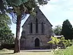 | |||
| 14, 16, 18, 20 Back Road | 56°09′59″N 3°40′35″W | Category B | 24589 | | |||
| 1 Thorntonbank Road | 56°09′55″N 3°40′55″W | Category C(S) | 24590 | | |||
| Castle Campbell Hall | 56°10′00″N 3°40′15″W | Category C(S) | 24591 | | |||
| 2 High Street (Burnside) | 56°10′00″N 3°40′14″W | Category C(S) | 24592 | | |||
| 34 High Street | 56°10′02″N 3°40′05″W | Category C(S) | 24597 | | |||
| 15 And 17 High Street | 56°10′01″N 3°40′13″W | Category B | 24600 | | |||
| 31 And 33 High Street | 56°10′03″N 3°40′07″W | Category C(S) | 24603 | | |||
| 2 Argyll Street | 56°09′58″N 3°40′06″W | Category C(S) | 24611 | | |||
| 1 And 3 Muckart Road (Gladstone Terrace) | 56°09′49″N 3°40′05″W | Category C(S) | 24616 | | |||
| 24 West Burnside (Burnside House) | 56°09′55″N 3°40′18″W | Category B | 24540 | | |||
| 6 Bridge Street | 56°09′47″N 3°40′14″W | Category C(S) | 24553 | | |||
| 10, 12 And 14 Bridge Street | 56°09′47″N 3°40′18″W | Category C(S) | 24555 | | |||
| Strathdevon | 56°09′48″N 3°41′25″W | Category C(S) | 1928 | | |||
| Drinking Fountain And Trough By Roadside At Broomrig | 56°09′46″N 3°41′30″W | Category B | 1929 | | |||
| Broomrig | 56°09′46″N 3°41′36″W | Category B | 1930 | | |||
| Bellmont | 56°09′45″N 3°41′46″W | Category C(S) | 1933 | | |||
| Ochilton | 56°09′37″N 3°40′35″W | Category B | 1938 | | |||
| Entrance Lodge, Dollarbeg | 56°08′54″N 3°39′14″W | Category B | 1940 | | |||
| Faerwood Cottages (East And West) | 56°09′49″N 3°41′15″W | Category B | 1942 | | |||
| 50-62 Bridge Street | 56°09′47″N 3°40′25″W | Category C(S) | 24559 | | |||
| 5-23 Bridge Street | 56°09′46″N 3°40′20″W | Category C(S) | 24566 | | |||
| 61 Bridge Street | 56°09′45″N 3°40′32″W | Category C(S) | 24569 | | |||
| 3 Manor House Road (Ingleside) | 56°09′50″N 3°40′27″W | Category C(S) | 24573 | | |||
| 4 High Street | 56°10′00″N 3°40′13″W | Category C(S) | 24593 | | |||
| 8 High Street | 56°10′01″N 3°40′12″W | Category C(S) | 24595 | | |||
| 40 And 42 High Street (No.40 Baldinnes) (No.42 The Luggy) | 56°10′03″N 3°40′03″W | Category C(S) | 24599 | | |||
| 25 And 27 High Street | 56°10′02″N 3°40′10″W | Category C(S) | 24602 | | |||
| Dollar Manse Manse Road | 56°09′52″N 3°40′11″W | Category C(S) | 24524 | | |||
| 1 East Burnside | 56°09′48″N 3°40′15″W | Category C(S) | 24525 | | |||
| The Session House 3 And 4 East Burnside | 56°09′51″N 3°40′15″W | Category B | 24528 | | |||
| 11 East Burnside | 56°09′55″N 3°40′15″W | Category C(S) | 24533 | | |||
| 12 East Burnside (Glen Lodge) | 56°09′56″N 3°40′16″W | Category C(S) | 24534 | | |||
| 18 And 19 West Burnside | 56°09′49″N 3°40′18″W | Category C(S) | 24538 | | |||
| Primary And Infant School Manor Park Road | 56°09′51″N 3°40′23″W | Category C(S) | 24543 | | |||
| 2,4,6 Academy Place | 56°09′53″N 3°40′20″W | Category B | 24552 | | |||
| Bellville Cottage | 56°09′44″N 3°41′40″W | Category C(S) | 1931 | | |||
| Mount Devon House Back Road | 56°09′46″N 3°41′42″W | Category B | 1932 | | |||
| East Lodge | 56°09′38″N 3°42′02″W | Category B | 1935 | | |||
| 70 Bridge Street (Sycamore) | 56°09′46″N 3°40′31″W | Category C(S) | 24561 | | |||
| 86 Bridge Street | 56°09′46″N 3°40′36″W | Category B | 24562 | | |||
| 55-59 Bridge Street | 56°09′45″N 3°40′30″W | Category C(S) | 24568 | | |||
| 13 Mcnabb Street (Speedwell) | 56°09′47″N 3°40′28″W | Category B | 24572 | | |||
| West Church Manse | 56°09′43″N 3°40′40″W | Category C(S) | 24576 | | |||
| 20 And 22 Harviestoun Road | 56°09′49″N 3°40′54″W | Category C(S) | 24585 | | |||
| Seberham No.1 Bridge Street | 56°09′47″N 3°40′08″W | Category B | 24587 | | |||
| 32 High Street (South View) | 56°10′02″N 3°40′06″W | Category C(S) | 24596 | | |||
| 19 And 21 High Street | 56°10′02″N 3°40′11″W | Category B | 24601 | | |||
| 23 Hillfoot Road | 56°10′05″N 3°40′07″W | Category C(S) | 24608 | | |||
| 4 Argyll Street | 56°09′59″N 3°40′06″W | Category C(S) | 24612 | | |||
| 17 Sorley's Brae | 56°09′59″N 3°40′09″W | Category C(S) | 24615 | | |||
| 13 East Burnside | 56°09′57″N 3°40′15″W | Category C(S) | 24535 | | |||
| Middle Bridge Over Dollar Burn, East And West Burnside | 56°09′51″N 3°40′17″W | Category B | 24541 | | |||
| North Bridge Over Dollar Burn, High Street - Back Road | 56°09′59″N 3°40′16″W | Category C(S) | 24542 | | |||
| 1, 3, 5 Academy Place | 56°09′52″N 3°40′19″W | Category B | 24551 | | |||
| Castle Campbell | 56°10′30″N 3°40′29″W | Category A | 1941 | 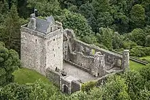 | |||
| 24, 26 And 28 Harviestoun Road | 56°09′48″N 3°40′57″W | Category B | 24586 | | |||
| 21 Hillfoot Road | 56°10′05″N 3°40′08″W | Category C(S) | 24607 | | |||
| 7 & 9 Muckart Road | 56°09′50″N 3°40′01″W | Category C(S) | 24617 | | |||
| 1 Manse Road, Keepers Cottage In Corner Of Graveyard | 56°09′50″N 3°40′08″W | Category C(S) | 24620 | | |||
| Church Hall | 56°09′50″N 3°40′15″W | Category C(S) | 24527 | | |||
| 20, 21 And 22 West Burnside | 56°09′50″N 3°40′18″W | Category C(S) | 24539 | | |||
| Dollar Academy | 56°09′54″N 3°40′28″W | Category A | 24546 | | |||
| East Gates, Academy Place Dollar Academy | 56°09′53″N 3°40′23″W | Category C(S) | 24549 | | |||
| Wester Sheardale | 56°09′15″N 3°42′03″W | Category B | 1936 | | |||
| Springhill | 56°09′49″N 3°41′13″W | Category C(S) | 1943 | | |||
| 10 Sorley's Brae | 56°09′57″N 3°40′11″W | Category C(S) | 24613 | | |||
| 12, 14 And 16 Sorley's Brae | 56°09′57″N 3°40′11″W | Category C(S) | 24614 | | |||
| 4 Manse Road (Eastfield) | 56°09′50″N 3°40′06″W | Category C(S) | 24619 | | |||
| Harviestoun Road, K6 Telephone Kiosk | 56°09′48″N 3°40′49″W | Category B | 24622 | | |||
| Old Parish Church, Dollar And Adjoining Building At Churchyard Gate Within The Churchyard Of Present Parish Church | 56°09′51″N 3°40′13″W | Category B | 24523 | | |||
| 5 East Burnside | 56°09′52″N 3°40′15″W | Category C(S) | 24529 | | |||
| 6 East Burnside (Argyll Cottage) | 56°09′53″N 3°40′15″W | Category B | 24530 |  | |||
| South East Gates Facing Cairnpark Street, Dollar Academy | 56°09′51″N 3°40′25″W | Category C(S) | 24550 | | |||
| 8 Bridge Street | 56°09′47″N 3°40′14″W | Category B | 24554 | | |||
| 16-24 Bridge Street | 56°09′47″N 3°40′19″W | Category C(S) | 24556 | | |||
| 26 Bridge Street (Homefield) | 56°09′47″N 3°40′20″W | Category B | 24557 | | |||
| 1 Mcnabb Street | 56°09′49″N 3°40′29″W | Category C(S) | 24570 | | |||
| Dollar West Church | 56°09′44″N 3°40′41″W | Category C(S) | 24575 | | |||
| 10 Harviestoun Road | 56°09′47″N 3°40′43″W | Category C(S) | 24580 | | |||
| Rectory 12 Harviestoun Road | 56°09′48″N 3°40′44″W | Category B | 24582 | | |||
| 18 Harviestoun Road | 56°09′49″N 3°40′53″W | Category C(S) | 24584 | | |||
| 2 Manse Road | 56°09′50″N 3°40′06″W | Category C(S) | 24618 | | |||
| Bridge Street, K6 Telephone Kiosk | 56°09′50″N 3°40′08″W | Category B | 24621 | | |||
| Parish Church Of St Columba, Dollar | 56°09′49″N 3°40′11″W | Category B | 24522 | | |||
| 17 West Burnside | 56°09′49″N 3°40′18″W | Category C(S) | 24537 | | |||
| 1 Chapel Place | 56°09′51″N 3°40′18″W | Category C(S) | 24544 | | |||
| Birchgrove | 56°09′47″N 3°41′22″W | Category C(S) | 1927 | | |||
| Clydesdale Bank Bridge Street | 56°09′46″N 3°40′15″W | Category B | 24563 | | |||
| Castle Campbell Hotel | 56°09′46″N 3°40′18″W | Category C(S) | 24564 | | |||
| 13 Bridge Street | 56°09′46″N 3°40′19″W | Category C(S) | 24565 | | |||
| 2 Harviestoun Road | 56°09′46″N 3°40′41″W | Category C(S) | 24578 | | |||
| 14 And 16 Harviestoun Road | 56°09′49″N 3°40′52″W | Category C(S) | 24583 | | |||
| 6 High Street | 56°10′00″N 3°40′12″W | Category C(S) | 24594 | | |||
| 11 Hillfoot Road | 56°10′04″N 3°40′10″W | Category C(S) | 24605 | | |||
| 25 Hillfoot Road (The Broomieknowe) | 56°10′06″N 3°40′06″W | Category B | 24609 | | |||
| 14 East Burnside (Norwood) | 56°09′58″N 3°40′15″W | Category C(S) | 24536 | | |||
| 3 Chapel Place (Park House) | 56°09′50″N 3°40′20″W | Category B | 24545 | | |||
| West Gates Facing Mylne Avenue Dollar Academy | 56°09′52″N 3°40′36″W | Category C(S) | 24548 | | |||
| Devongrove Harviestoun Road | 56°09′44″N 3°41′18″W | Category B | 1937 | | |||
| Dollarbeg | 56°08′59″N 3°39′25″W | Category B | 1939 | |
Key
The scheme for classifying buildings in Scotland is:
- Category A: "buildings of national or international importance, either architectural or historic; or fine, little-altered examples of some particular period, style or building type."[1]
- Category B: "buildings of regional or more than local importance; or major examples of some particular period, style or building type, which may have been altered."[1]
- Category C: "buildings of local importance; lesser examples of any period, style, or building type, as originally constructed or moderately altered; and simple traditional buildings which group well with other listed buildings."[1]
In March 2016 there were 47,288 listed buildings in Scotland. Of these, 8% were Category A, and 50% were Category B, with the remaining 42% being Category C.[2]
Notes
- Sometimes known as OSGB36, the grid reference (where provided) is based on the British national grid reference system used by the Ordnance Survey.
• "Guide to National Grid". Ordnance Survey. Retrieved 12 December 2007.
• "Get-a-map". Ordnance Survey. Retrieved 17 December 2007. - Historic Environment Scotland assign a unique alphanumeric identifier to each designated site in Scotland, for listed buildings this always begins with "LB", for example "LB12345".
References
- All entries, addresses and coordinates are based on data from Historic Scotland. This data falls under the Open Government Licence
- "What is Listing?". Historic Environment Scotland. Retrieved 29 May 2018.
- Scotland's Historic Environment Audit 2016 (PDF). Historic Environment Scotland and the Built Environment Forum Scotland. pp. 15–16. Retrieved 29 May 2018.
This article is issued from Wikipedia. The text is licensed under Creative Commons - Attribution - Sharealike. Additional terms may apply for the media files.