List of listed buildings in Dornoch, Highland
List
| Name | Location | Date Listed | Grid Ref. [note 1] | Geo-coordinates | Notes | LB Number [note 2] | Image |
|---|---|---|---|---|---|---|---|
| 7 Castle Street The Eagle Hotel | 57°52′51″N 4°01′59″W | Category B | 24628 | 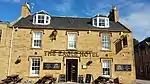 | |||
| Castle Street West Deanery | 57°52′49″N 4°01′53″W | Category C(S) | 24629 | 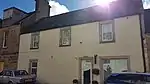 | |||
| Earl's Cross House | 57°53′08″N 4°01′11″W | Category B | 24641 |  | |||
| 2, 3, 4, 5 Gilchrist Square | 57°52′51″N 4°01′46″W | Category B | 24643 | | |||
| High Street Mercat Cross | 57°52′50″N 4°01′46″W | Category B | 24646 | | |||
| Kennedy Avenue Links House | 57°52′45″N 4°01′28″W | Category B | 24649 | | |||
| Skelbo Steading | 57°55′40″N 4°02′40″W | Category B | 596 | | |||
| Skibo Castle And Garden Terraces, Walled Garden And Glasshouses | 57°52′27″N 4°08′00″W | Category A | 597 | .jpg.webp) | |||
| Skibo Castle Swimming Pool | 57°52′18″N 4°08′06″W | Category B | 601 | | |||
| 1 And 2 Castle Street | 57°52′51″N 4°02′03″W | Category C(S) | 24624 | 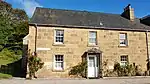 | |||
| 5 And 6 Castle Street | 57°52′51″N 4°02′00″W | Category C(S) | 24627 | 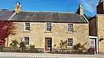 | |||
| Castle Street The Deanery | 57°52′49″N 4°01′52″W | Category B | 24630 | 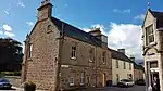 | |||
| Castle Street Clydesdale Bank | 57°52′50″N 4°02′03″W | Category C(S) | 24635 | 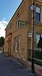 | |||
| Castle Street Old Jail And Former Drill Hall | 57°52′47″N 4°01′43″W | Category B | 24638 | 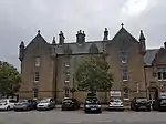 | |||
| Church Street Free Church Of Scotland, Church Room (Former School), Burial Ground And Gate Piers With Front Retaining Wall | 57°52′46″N 4°01′36″W | Category B | 24640 | | |||
| Off High Street Tornaver | 57°52′56″N 4°01′43″W | Category B | 24648 | | |||
| Skibo Castle Former Electric House And Private Telephone Exchange (Now Garage) With Pair Dwellings, "Loch Ospisdale East" And "Loch Ospisdale West" | 57°52′19″N 4°08′07″W | Category B | 600 | | |||
| Cuthill Farm Cottages | 57°51′43″N 4°06′16″W | Category C(S) | 606 | | |||
| Castle Street, Gleann Golliadh | 57°52′51″N 4°02′02″W | Category C(S) | 24625 | 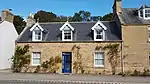 | |||
| Castle Street Police Station | 57°52′46″N 4°01′41″W | Category C(S) | 24639 | | |||
| Nos 1, 2 And 3 High Street Dornoch Bakery (Nos 1 And 2) And Swyn-Y-Coed | 57°52′51″N 4°01′51″W | Category B | 24647 | | |||
| Clashmore Carnegie Hall | 57°52′42″N 4°06′53″W | Category B | 602 | | |||
| Evelix Old Bridge Over River Evelix | 57°53′11″N 4°04′44″W | Category B | 609 | | |||
| Meikle Ferry Pier | 57°51′14″N 4°08′37″W | Category C(S) | 610 | 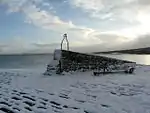 | |||
| Castle Street The White House | 57°52′49″N 4°01′51″W | Category C(S) | 24631 | 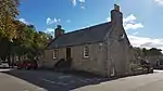 | |||
| Castle Street Fountain | 57°52′48″N 4°01′48″W | Category B | 24633 | 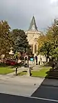 | |||
| Castle Street County Buildings And Courthouse | 57°52′47″N 4°01′46″W | Category B | 24637 | 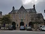 | |||
| Skibo Castle Dairy And Dairy House | 57°52′32″N 4°07′51″W | Category B | 599 | | |||
| Station Road St Michael's Well | 57°53′00″N 4°01′38″W | Category C(S) | 24652 | | |||
| Castle Street Dornoch Castle (Castle Hotel) And Garden Wall | 57°52′47″N 4°01′48″W | Category B | 24636 | 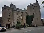 | |||
| Skibo Castle Bridge Spanning Outfall Of Lake Ospidale | 57°52′13″N 4°08′09″W | Category C(S) | 598 | | |||
| Embo House | 57°54′13″N 4°00′41″W | Category A | 608 | .jpg.webp) | |||
| Skelbo Castle And House Within Castle Enclosure | 57°55′47″N 4°02′28″W | Category B | 611 | | |||
| Station Road St Michaels | 57°52′50″N 4°01′40″W | Category B | 24651 | | |||
| 2 And 3 Argyle Street | 57°52′49″N 4°01′33″W | Category C(S) | 24623 | | |||
| 6 And 7 Gilchrist Square | 57°52′52″N 4°01′44″W | Category B | 24644 | | |||
| Station Road Netherwood | 57°52′54″N 4°01′40″W | Category B | 24650 | | |||
| Two K6 Telephone Kiosks In The Square | 57°52′48″N 4°01′43″W | Category B | 51108 | | |||
| Castle Street Dornoch Cathedral And Walled Grave Yard. (Cathedral Of St. Mary And St Gilbert. Church Of Scotland Parish Church) | 57°52′50″N 4°01′48″W | Category A | 24632 | 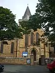 | |||
| Castle Street Old Post Office (Tourist Office) | 57°52′48″N 4°01′42″W | Category B | 24634 | | |||
| 8 Gilchrist Square | 57°52′52″N 4°01′43″W | Category B | 24645 | | |||
| Cuthill Farmhouse | 57°51′42″N 4°06′18″W | Category B | 605 | | |||
| 4 Castle Street | 57°52′51″N 4°02′02″W | Category C(S) | 24626 | 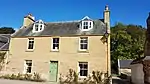 | |||
| 1 Gilchrist Square | 57°52′51″N 4°01′46″W | Category B | 24642 | | |||
| Clashmore Oakfield | 57°52′41″N 4°06′56″W | Category B | 603 | | |||
| Coul Farmhouse | 57°55′12″N 4°00′40″W | Category B | 604 | | |||
| Cyderhall Farmhouse | 57°52′10″N 4°05′44″W | Category B | 607 | |
Key
The scheme for classifying buildings in Scotland is:
- Category A: "buildings of national or international importance, either architectural or historic; or fine, little-altered examples of some particular period, style or building type."[1]
- Category B: "buildings of regional or more than local importance; or major examples of some particular period, style or building type, which may have been altered."[1]
- Category C: "buildings of local importance; lesser examples of any period, style, or building type, as originally constructed or moderately altered; and simple traditional buildings which group well with other listed buildings."[1]
In March 2016 there were 47,288 listed buildings in Scotland. Of these, 8% were Category A, and 50% were Category B, with the remaining 42% being Category C.[2]
Notes
- Sometimes known as OSGB36, the grid reference (where provided) is based on the British national grid reference system used by the Ordnance Survey.
• "Guide to National Grid". Ordnance Survey. Retrieved 12 December 2007.
• "Get-a-map". Ordnance Survey. Retrieved 17 December 2007. - Historic Environment Scotland assign a unique alphanumeric identifier to each designated site in Scotland, for listed buildings this always begins with "LB", for example "LB12345".
References
- All entries, addresses and coordinates are based on data from Historic Scotland. This data falls under the Open Government Licence
- "What is Listing?". Historic Environment Scotland. Retrieved 29 May 2018.
- Scotland's Historic Environment Audit 2016 (PDF). Historic Environment Scotland and the Built Environment Forum Scotland. pp. 15–16. Retrieved 29 May 2018.
This article is issued from Wikipedia. The text is licensed under Creative Commons - Attribution - Sharealike. Additional terms may apply for the media files.