List of listed buildings in Eastwood, East Renfrewshire
List
| Name | Location | Date Listed | Grid Ref. [note 1] | Geo-coordinates | Notes | LB Number [note 2] | Image |
|---|---|---|---|---|---|---|---|
| Rhuallan House, 1 Montgomery Drive, Giffnock | 55°47′53″N 4°17′48″W | Category B | 5121 |  | |||
| Clarkston Road Maclaren Place | 55°48′09″N 4°16′12″W | Category B | 5126 | | |||
| Giffnock, 192-210 (Even Nos) Fenwick Road, Maverton Buildings | 55°48′06″N 4°17′44″W | Category C(S) | 5133 | | |||
| Orchardhill Church Of Scotland, Church Road, Giffnock | 55°48′01″N 4°17′36″W | Category B | 5123 | | |||
| Unitas Building, 2-12 Main Street, Thornliebank | 55°48′21″N 4°19′07″W | Category C(S) | 87 | | |||
| Aurs Road, Main House Including Workshops And Former Water Testing Tower | 55°47′40″N 4°21′26″W | Category C(S) | 51184 | | |||
| Giffnock South Church Of Scotland, Greenhill Avenue, Giffnock | 55°47′44″N 4°18′01″W | Category B | 5125 | 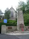 | |||
| "Eastwood Park" Rouken Glen Road, Giffnock | 55°47′55″N 4°18′23″W | Category C(S) | 5128 | | |||
| Alexander Crum Memorial Library, Speirsbridge Road, Thornliebank | 55°48′19″N 4°19′07″W | Category B | 5131 | | |||
| 4 Park Road/Fenwick Road, Orchard Park Hotel | 55°48′08″N 4°17′44″W | Category C(S) | 5122 | | |||
| 43 Ayr Road, Whitecraigs House, Including Terraces And Staircase, Perimeter Wall And Gatepiers | 55°47′19″N 4°18′29″W | Category B | 6625 | | |||
| Thornliebank Public School, Main Street, Thornliebank | 55°48′34″N 4°18′51″W | Category B | 5129 | 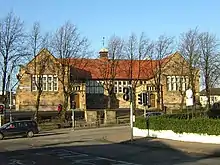 | |||
| 2 And 4 Mains Avenue, Giffnock | 55°47′46″N 4°18′02″W | Category C(S) | 47276 | | |||
| Thornliebank (Woodlands) Parish Church | 55°48′11″N 4°19′08″W | Category C(S) | 5130 | | |||
| Eastwood Toll, Lodge House And Gatepiers At Eastwood Park | 55°47′48″N 4°18′09″W | Category B | 5132 | | |||
| "Old Mains", Cadzow Avenue, Giffnock | 55°47′35″N 4°17′55″W | Category B | 5124 | | |||
| "Eastwoodhill" 238 Fenwick Road, Giffnock | 55°47′51″N 4°17′59″W | Category B | 5127 | |
Key
The scheme for classifying buildings in Scotland is:
- Category A: "buildings of national or international importance, either architectural or historic; or fine, little-altered examples of some particular period, style or building type."[1]
- Category B: "buildings of regional or more than local importance; or major examples of some particular period, style or building type, which may have been altered."[1]
- Category C: "buildings of local importance; lesser examples of any period, style, or building type, as originally constructed or moderately altered; and simple traditional buildings which group well with other listed buildings."[1]
In March 2016 there were 47,288 listed buildings in Scotland. Of these, 8% were Category A, and 50% were Category B, with the remaining 42% being Category C.[2]
Notes
- Sometimes known as OSGB36, the grid reference (where provided) is based on the British national grid reference system used by the Ordnance Survey.
• "Guide to National Grid". Ordnance Survey. Retrieved 2007-12-12.
• "Get-a-map". Ordnance Survey. Retrieved 2007-12-17. - Historic Environment Scotland assign a unique alphanumeric identifier to each designated site in Scotland, for listed buildings this always begins with "LB", for example "LB12345".
References
- All entries, addresses and coordinates are based on data from Historic Scotland. This data falls under the Open Government Licence
- "What is Listing?". Historic Environment Scotland. Retrieved 29 May 2018.
- Scotland's Historic Environment Audit 2016 (PDF). Historic Environment Scotland and the Built Environment Forum Scotland. pp. 15–16. Retrieved 29 May 2018.
This article is issued from Wikipedia. The text is licensed under Creative Commons - Attribution - Sharealike. Additional terms may apply for the media files.