List of listed buildings in Elgin, Moray
List
| Name | Location | Date Listed | Grid Ref. [note 1] | Geo-coordinates | Notes | LB Number [note 2] | Image |
|---|---|---|---|---|---|---|---|
| 3 Reidhaven Street | 57°38′48″N 3°18′50″W | Category B | 30868 |  | |||
| 19 Reidhaven Street | 57°38′44″N 3°18′46″W | Category C(S) | 30872 | | |||
| 23 Reidhaven Street | 57°38′43″N 3°18′45″W | Category B | 30874 | | |||
| 47 Reidhaven Street | 57°38′38″N 3°18′39″W | Category C(S) | 30880 | | |||
| 16 Harrow Inn Close | 57°38′52″N 3°18′55″W | Category C(S) | 30885 | | |||
| 64-102 Even Nos Only South College Street (Even Numbers Only) | 57°38′54″N 3°18′15″W | Category B | 30893 | | |||
| 13 South Guildry Street | 57°38′44″N 3°18′51″W | Category B | 30896 | | |||
| 7 West Road | 57°38′48″N 3°19′39″W | Category C(S) | 30913 | | |||
| 17 West Road | 57°38′49″N 3°19′46″W | Category C(S) | 30915 | | |||
| 19 West Road, Craigie | 57°38′49″N 3°19′47″W | Category B | 30916 | | |||
| 147-149 High Street | 57°38′56″N 3°18′58″W | Category B | 30752 | | |||
| 171-177 (Odd Nos) High Street | 57°38′55″N 3°19′02″W | Category C(S) | 30755 | | |||
| 227B High Street (In Close) | 57°38′54″N 3°19′11″W | Category B | 30765 | | |||
| 82, 84, 86 High Street | 57°38′55″N 3°18′52″W | Category B | 30785 | | |||
| 114A High Street (Through Pend, Harrow Inn Close) | 57°38′54″N 3°18′57″W | Category C(S) | 30792 | | |||
| 14, 15 Harrow Inn Close | 57°38′53″N 3°18′56″W | Category C(S) | 30797 | | |||
| 1 King Street, Winchester House And Garden Walls | 57°38′59″N 3°18′24″W | Category B | 30813 | | |||
| 7 King Street | 57°38′58″N 3°18′24″W | Category C(S) | 30814 | | |||
| 13 And 15 King Street | 57°38′57″N 3°18′23″W | Category C(S) | 30816 | | |||
| Maisondieu Road, Railway Station (Formerly Great North Of Scotland Railway) | 57°38′36″N 3°18′27″W | Category B | 30825 | | |||
| 50 Moss Street | 57°38′44″N 3°18′37″W | Category B | 30835 | | |||
| Abbey Street, Convent Of Mercy, Chapel | 57°38′53″N 3°18′34″W | Category A | 30681 | 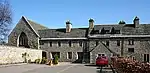 | |||
| 1-55 (Odd Nos) Harrison Terrace | 57°39′27″N 3°19′01″W | Category B | 30693 | | |||
| Deanshaugh, Deansburgh House And Outbuilding | 57°39′16″N 3°18′29″W | Category B | 30702 | | |||
| 8, 10 Forteath Avenue With Garden Walls | 57°38′39″N 3°19′17″W | Category B | 30705 | | |||
| 5A High Street (Through Pend) | 57°38′57″N 3°18′37″W | Category B | 30716 | | |||
| 5D High Street (Through Pend) | 57°38′57″N 3°18′37″W | Category C(S) | 30719 | | |||
| 7 High Street, Braco's Banking House | 57°38′56″N 3°18′37″W | Category A | 30720 | 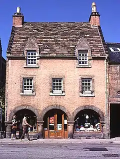 | |||
| 23 High Street | 57°38′56″N 3°18′40″W | Category B | 30723 | | |||
| 25B High Street (Through Pend) | 57°38′57″N 3°18′41″W | Category B | 30729 | | |||
| 87C,D High Street (Through Pend) | 57°38′57″N 3°18′51″W | Category C(S) | 30735 | | |||
| 91A High Street (Through Pend) | 57°38′57″N 3°18′51″W | Category C(S) | 30736 | | |||
| 103-107 High Street, The Tower Hotel | 57°38′57″N 3°18′53″W | Category B | 30744 | | |||
| 135-139 High Street | 57°38′57″N 3°18′58″W | Category C(S) | 30750 | | |||
| Pittendreich Dovecot | 57°38′03″N 3°20′55″W | Category A | 8439 | | |||
| 17 Batchen Street | 57°38′53″N 3°19′01″W | Category C(S) | 43372 | | |||
| 39-45 (Odd Nos) Reidhaven Street | 57°38′39″N 3°18′40″W | Category B | 30879 | | |||
| Northfield Terrace, Highfield House And Former Carriage House, Elgin Community Surgery | 57°38′49″N 3°19′12″W | Category B | 30888 | | |||
| South Street, High Church (Church Of Scotland) | 57°38′49″N 3°18′57″W | Category B | 30890 | | |||
| 56-58 South Street | 57°38′51″N 3°18′58″W | Category B | 30892 | | |||
| 229F High Street(Through Pend) | 57°38′54″N 3°19′12″W | Category C(S) | 30768 | | |||
| 233 And 235 High Street | 57°38′53″N 3°19′12″W | Category C(S) | 30770 | | |||
| 233C,D High Street (Through Pend) | 57°38′54″N 3°19′12″W | Category C(S) | 30772 | | |||
| 239 High Street | 57°38′53″N 3°19′12″W | Category C(S) | 30774 | | |||
| 102, 104, 106, 108 High Street | 57°38′55″N 3°18′55″W | Category C(S) | 30789 | | |||
| 128, 130, 132, 134, 136 High Street | 57°38′54″N 3°18′59″W | Category B | 30799 | | |||
| 21 Institution Road, Moray Bank | 57°38′48″N 3°18′39″W | Category B | 30807 | | |||
| 17 King Street | 57°38′57″N 3°18′23″W | Category C(S) | 30817 | | |||
| 10 King Street | 57°38′58″N 3°18′22″W | Category B | 30819 | | |||
| 16, 18 And 18A King Street | 57°38′57″N 3°18′22″W | Category C(S) | 30820 | | |||
| 9A Moss Street, High Spirits , Formerly Moss Street United Presbyterian Church | 57°38′52″N 3°18′47″W | Category C(S) | 30837 | | |||
| Newmill Garvald House, Walling, Gate Piers And Pedestrian Entrance | 57°39′05″N 3°18′01″W | Category C(S) | 30846 | | |||
| Trinity Place, Holy Trinity Episcopal Church | 57°39′01″N 3°19′04″W | Category B | 30848 | | |||
| Trinity Place, Holy Trinity Church Hall (Formerly School) | 57°39′01″N 3°19′04″W | Category C(S) | 30849 | | |||
| North College Street, Elgin Cathedral Enclosing Wall And Gates | 57°39′02″N 3°18′20″W | Category A | 30853 | | |||
| North College Street, Elgin Cathedral "Bishop's House" | 57°39′04″N 3°18′24″W | Category A | 30854 | | |||
| 13 North College Street, "Downham" | 57°38′58″N 3°18′31″W | Category C(S) | 30857 | | |||
| Old Mills Road, Bridge Approaching The Mill And Ancillary Buildings | 57°38′58″N 3°19′52″W | Category C(S) | 30861 | | |||
| 33 Abbey Street, Heatherley | 57°38′48″N 3°18′34″W | Category C(S) | 30683 | | |||
| Bishopmill, 1 Bridge Street | 57°39′10″N 3°18′55″W | Category C(S) | 30687 | | |||
| Blackfriars Road, Lodge To Mansion House Hotel (Formerly The Haugh) | 57°38′57″N 3°19′21″W | Category C(S) | 30699 | | |||
| High Street, Little Cross | 57°38′56″N 3°18′36″W | Category A | 30709 | | |||
| 3 High Street | 57°38′56″N 3°18′37″W | Category C(S) | 30715 | | |||
| 25 High Street | 57°38′56″N 3°18′41″W | Category B | 30727 | | |||
| 25A High Street | 57°38′57″N 3°18′41″W | Category B | 30728 | | |||
| 37F High Street, (Through Pend) | 57°38′57″N 3°18′42″W | Category C(S) | 30731 | | |||
| 87A High Street (Through Pend) | 57°38′57″N 3°18′51″W | Category C(S) | 30733 | | |||
| 91C,D High Street (Through Pend) | 57°38′58″N 3°18′52″W | Category C(S) | 30738 | | |||
| Pend At Rear Of 95 High Street E-F | 57°38′57″N 3°18′52″W | Category C(S) | 30741 | | |||
| Coleburn Distillery, Duty Free 553 Warehouses, Office, Store, Cottage And Manager's House | 57°34′54″N 3°16′19″W | Category B | 8435 | | |||
| Pluscarden, Netherbyre | 57°36′11″N 3°25′19″W | Category C(S) | 8445 | | |||
| Elgin Town Hall, Including Former Water Feature And Flagpoles | 57°39′02″N 3°18′58″W | Category B | 47391 | | |||
| Pluscarden Road, Lodge To Gray's Hospital | 57°38′44″N 3°19′41″W | Category B | 30865 | | |||
| 11 Reidhaven Street | 57°38′46″N 3°18′49″W | Category C(S) | 30869 | | |||
| 21 Reidhaven Street | 57°38′44″N 3°18′46″W | Category C(S) | 30873 | | |||
| 49 Reidhaven Street | 57°38′37″N 3°18′38″W | Category B | 30881 | | |||
| 3-17 (Odd Nos) Victoria Road, Jubilee Homes (Odd Number Only) | 57°38′49″N 3°18′03″W | Category C(S) | 30909 | | |||
| 3 West Road | 57°38′48″N 3°19′37″W | Category C(S) | 30911 | | |||
| West Road, Connet Hill | 57°38′51″N 3°20′13″W | Category B | 30917 | | |||
| Northfield Terrace, St Michael's (Former Episcopalian) Rectory With Garden Walls | 57°38′49″N 3°19′09″W | Category B | 30921 | | |||
| 161-163 High Street | 57°38′55″N 3°19′01″W | Category B | 30753 | | |||
| 185 High Street | 57°38′55″N 3°19′04″W | Category C(S) | 30757 | | |||
| 211E High Street (In Close) | 57°38′55″N 3°19′09″W | Category C(S) | 30763 | | |||
| 229G High Street(Throiugh Pend) | 57°38′55″N 3°19′12″W | Category C(S) | 30769 | | |||
| 76, 78, 80 High Street | 57°38′55″N 3°18′51″W | Category B | 30784 | | |||
| 94 High Street | 57°38′55″N 3°18′53″W | Category B | 30787 | | |||
| 96-98 High Street, 100 High Street | 57°38′54″N 3°18′54″W | Category B | 30788 | | |||
| 3, 4, 5, 6 Harrow Inn Close | 57°38′54″N 3°18′56″W | Category C(S) | 30793 | | |||
| 184, 186, 188 High Street | 57°38′53″N 3°19′08″W | Category B | 30801 | | |||
| Institution Road, East End School | 57°38′35″N 3°18′18″W | Category B | 30811 | | |||
| 27 Moray Street With 14 And 16 North Guildry Street | 57°38′47″N 3°18′55″W | Category C(S) | 30832 | | |||
| 41 Moss Street, South Villa, Garden Walls And Ice House | 57°38′42″N 3°18′41″W | Category A | 30839 | | |||
| Newmill, Newmill Warehouse Front Block | 57°39′06″N 3°17′58″W | Category B | 30842 | | |||
| Newmill, Newmill Warehouse And Weaving Shed | 57°39′06″N 3°17′58″W | Category C(S) | 30843 | | |||
| Newmill, Newmill Cottages (Formerly Newmill House Stables) | 57°39′06″N 3°18′00″W | Category C(S) | 30845 | | |||
| Old Mills Road, The Mill And Ancillary Working Buildings | 57°39′00″N 3°19′54″W | Category B | 30860 | | |||
| Bishopmill, Braemoriston Road, Braemoriston House | 57°39′15″N 3°19′17″W | Category B | 30685 | | |||
| Bishopmill, Woodlands Farm, Horse Engine House | 57°39′33″N 3°19′31″W | Category B | 30697 | | |||
| High Street, Fountain On The Plainstones | 57°38′55″N 3°18′59″W | Category B | 30710 | | |||
| 15 And 17 High Street, Masonic Building | 57°38′56″N 3°18′39″W | Category B | 30722 | | |||
| 85,87,89,91,93 High Street | 57°38′56″N 3°18′50″W | Category C(S) | 30732 | | |||
| 91E And 91F High Street (Through Pend) | 57°38′58″N 3°18′52″W | Category C(S) | 30739 | | |||
| 109 High Street | 57°38′57″N 3°18′53″W | Category C(S) | 30745 | | |||
| Cowiesburn House (Former Free Church Manse) | 57°35′52″N 3°25′36″W | Category B | 8436 | | |||
| Pittendreich Bridge (Over Lochty Burn) | 57°38′14″N 3°20′51″W | Category B | 8440 | | |||
| Pluscarden, Abbey, Monastic Buildings And Precinct Walls | 57°36′00″N 3°26′09″W | Category A | 8441 | | |||
| 284 High Street, Fern Hurst, Former Civic Lamps | 57°38′47″N 3°19′31″W | Category C(S) | 45660 | | |||
| 6 Queen Street, Greyfriars House | 57°38′52″N 3°18′24″W | Category B | 30867 | | |||
| 29 Reidhaven Street | 57°38′41″N 3°18′43″W | Category C(S) | 30876 | | |||
| 31 Reidhaven Street | 57°38′40″N 3°18′42″W | Category C(S) | 30877 | | |||
| 3,4 St Catherine's Place And Garden Walls | 57°38′38″N 3°19′16″W | Category B | 30883 | | |||
| Sheriffmills Bridge | 57°38′56″N 3°20′23″W | Category B | 30884 | | |||
| 3 South College Street | 57°38′55″N 3°18′35″W | Category C(S) | 30894 | | |||
| 15 South Guildry Street | 57°38′43″N 3°18′51″W | Category C(S) | 30897 | | |||
| 25 And 29 South Guildry Street | 57°38′41″N 3°18′49″W | Category C(S) | 30899 | | |||
| 5 West Road | 57°38′48″N 3°19′38″W | Category C(S) | 30912 | | |||
| 9 West Road, Ingleside (Formerly The Cottage) | 57°38′49″N 3°19′42″W | Category A | 30914 | | |||
| 211, 211A And 211B High Street | 57°38′54″N 3°19′08″W | Category C(S) | 30760 | | |||
| 233A,B High Street, (Through Pend) | 57°38′53″N 3°19′12″W | Category C(S) | 30771 | | |||
| 233E And 233F High Street, (Through Pend) | 57°38′54″N 3°19′12″W | Category C(S) | 30773 | | |||
| High Street, Lady Hill, Duke Of Gordon Monument | 57°38′54″N 3°19′21″W | Category A | 30775 | | |||
| 92 High Street (Through Pend) | 57°38′54″N 3°18′53″W | Category C(S) | 30786 | | |||
| 116-126 High Street (Former Gordon Arms Hotel) | 57°38′54″N 3°18′57″W | Category C(S) | 30798 | | |||
| 20 King Street | 57°38′56″N 3°18′21″W | Category B | 30821 | | |||
| 2 Mayne Road, The Mansefield House Hotel | 57°38′47″N 3°19′12″W | Category B | 30828 | | |||
| North College Street, Grant Lodge (Elgin Library) | 57°39′02″N 3°18′36″W | Category B | 30851 | .jpg.webp) | |||
| Abbey Street, Convent Of Mercy, Convent Buildings | 57°38′52″N 3°18′34″W | Category A | 30682 | | |||
| Bishopmill, 3 Bridge Street | 57°39′11″N 3°18′56″W | Category C(S) | 30688 | | |||
| Bishopmill, 2 Bridge Street | 57°39′10″N 3°18′57″W | Category C(S) | 30689 | | |||
| Bishopmill, East High Street, Deansford | 57°39′19″N 3°18′49″W | Category B | 30692 | | |||
| Bishopmill, 21 West High Street, Montpelier | 57°39′15″N 3°19′06″W | Category C(S) | 30695 | | |||
| Bishopmill, Hythe Hill, 23 West High Street, House, Gatepiers, Garden Walling, Former Gighouse And Stable | 57°39′15″N 3°19′08″W | Category B | 30696 | | |||
| 20 Duff Avenue, The Lodge | 57°38′41″N 3°18′23″W | Category B | 30704 | | |||
| 5B High Street (Through Pend) | 57°38′57″N 3°18′37″W | Category B | 30717 | | |||
| 87B High Street (Through Pend) | 57°38′57″N 3°18′51″W | Category C(S) | 30734 | | |||
| 101 High Street | 57°38′56″N 3°18′52″W | Category B | 30742 | | |||
| 141-145 High Street | 57°38′56″N 3°18′58″W | Category B | 30751 | | |||
| Clackmarras, Thornhill | 57°36′41″N 3°15′00″W | Category C(S) | 8434 | | |||
| 13 Reidhaven Street | 57°38′46″N 3°18′48″W | Category B | 30870 | | |||
| South Street, Park House (Centre) | 57°38′45″N 3°19′28″W | Category B | 30889 | | |||
| South College Street, Anderson's Institution And Gatepiers (The Elgin Institution For Support Of Old Age And Education Of Youth | 57°38′53″N 3°18′17″W | Category A | 30895 | 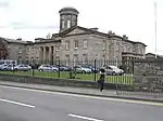 | |||
| 55, 57 South Guildry Street | 57°38′39″N 3°18′46″W | Category C(S) | 30901 | | |||
| 22, 22A, 24, 24A South Guildry Street | 57°38′41″N 3°18′51″W | Category C(S) | 30903 | | |||
| 31 Wittet Drive | 57°38′40″N 3°19′58″W | Category B | 30919 | | |||
| 1 High Street, K6 Telephone Kiosk At Museum | 57°38′57″N 3°18′35″W | Category B | 30920 | | |||
| 181 High Street | 57°38′55″N 3°19′03″W | Category C(S) | 30756 | | |||
| 211C High Street (In Close) | 57°38′55″N 3°19′09″W | Category C(S) | 30761 | | |||
| 211F High Street (In Close) | 57°38′56″N 3°19′09″W | Category C(S) | 30764 | | |||
| 227C High Street (In Close) | 57°38′54″N 3°19′11″W | Category C(S) | 30766 | | |||
| High Street, Maryhill House, Garden Walls And Bridge Linking Gardens And Spanning The Ladies Walk, Oldmills Road | 57°38′49″N 3°19′35″W | Category B | 30777 | | |||
| 42-46 High Street | 57°38′56″N 3°18′46″W | Category A | 30779 | | |||
| 50-52 High Street | 57°38′56″N 3°18′47″W | Category A | 30780 | | |||
| 54 High Street | 57°38′56″N 3°18′48″W | Category B | 30781 | | |||
| 7, 8, 9, 10 Harrow Inn Close | 57°38′53″N 3°18′56″W | Category C(S) | 30794 | | |||
| 11, 13 Harrow Inn Close | 57°38′53″N 3°18′56″W | Category C(S) | 30795 | | |||
| 184A,B,C High Street (Through Pend) | 57°38′52″N 3°19′07″W | Category C(S) | 30802 | | |||
| Institution Road, St Sylvester's Rc Church, Presbytery And School | 57°38′48″N 3°18′38″W | Category B | 30806 | | |||
| Institution Road, Lodge To Anderson's Institution | 57°38′52″N 3°18′22″W | Category B | 30812 | | |||
| Maisondieu Road, Laich Moray Hotel (Formerly Station Hotel) | 57°38′38″N 3°18′29″W | Category B | 30824 | | |||
| Maisondieu Road, Railway Station, Engine Shed | 57°38′43″N 3°17′55″W | Category B | 30826 | | |||
| 7 Mayne Road, Prospect Lodge | 57°38′45″N 3°19′18″W | Category B | 30827 | | |||
| Moray Street, Moray College Of Further Education (Former Elgin Academy) Fronting Moray Street, Arch And Bellcote | 57°38′44″N 3°19′00″W | Category B | 30830 | | |||
| 35 Moss Street, Girnigoe | 57°38′45″N 3°18′41″W | Category B | 30838 | | |||
| 1 North College Street | 57°38′56″N 3°18′35″W | Category B | 30850 | | |||
| 1, 3 Duff Avenue, Avenue House | 57°38′46″N 3°18′37″W | Category B | 30703 | | |||
| 26 Hay Street, Former South Manse | 57°38′44″N 3°19′05″W | Category B | 30707 | | |||
| High Street, War Memorial, On The Plainstones | 57°38′55″N 3°18′58″W | Category C(S) | 30711 | | |||
| 111-113 High Street | 57°38′56″N 3°18′54″W | Category C(S) | 30746 | | |||
| 117, 119 And 121 High Street | 57°38′56″N 3°18′55″W | Category C(S) | 30748 | | |||
| Miltonduff Dovecot | 57°37′29″N 3°22′27″W | Category C(S) | 8438 | | |||
| Pluscarden Abbey, Porter's Lodge | 57°35′58″N 3°25′59″W | Category B | 8442 | | |||
| Pansport Road, Pansport And Precinct Wall | 57°39′00″N 3°18′11″W | Category A | 30863 | | |||
| 62 Pluscarden Road, Fleurs House | 57°38′39″N 3°20′02″W | Category C(S) | 30866 | | |||
| 17 Reidhaven Street | 57°38′45″N 3°18′47″W | Category B | 30871 | | |||
| 33 Reidhaven Street | 57°38′39″N 3°18′41″W | Category C(S) | 30878 | | |||
| 69-71 South Street | 57°38′51″N 3°18′59″W | Category C(S) | 30887 | | |||
| South Street, Free Church | 57°38′50″N 3°19′02″W | Category C(S) | 30891 | | |||
| 49, 51, 53 South Guildry Street | 57°38′39″N 3°18′47″W | Category C(S) | 30900 | | |||
| 26, 28 South Guildry Street | 57°38′41″N 3°18′51″W | Category B | 30904 | | |||
| 165-167 High Street | 57°38′55″N 3°19′01″W | Category B | 30754 | | |||
| High Street, Sulva Cottage And Messines Cottage, Lady Hill. (War Veterans' Cottages) | 57°38′52″N 3°19′18″W | Category C(S) | 30776 | | |||
| 114 High Street (Through Pend, Harrow Inn Close) | 57°38′54″N 3°18′57″W | Category C(S) | 30791 | | |||
| Hill Street, Ladyhill House Hotel | 57°38′52″N 3°19′22″W | Category B | 30803 | | |||
| 23 Institution Road, Kinrara | 57°38′48″N 3°18′40″W | Category B | 30808 | | |||
| 8 Institution Road, Limuru | 57°38′50″N 3°18′26″W | Category B | 30810 | | |||
| Lesmurdie, Lesmurdie House | 57°39′22″N 3°17′56″W | Category B | 30822 | | |||
| Moray Street, South High Church, (Church Of Scotland) | 57°38′46″N 3°18′54″W | Category B | 30831 | | |||
| 42-46 Moss Street | 57°38′45″N 3°18′39″W | Category B | 30834 | | |||
| New Elgin, Doocot Park, Dovecot | 57°38′23″N 3°18′21″W | Category B | 30841 | | |||
| Newmill, Newmill House | 57°39′06″N 3°18′01″W | Category C(S) | 30844 | | |||
| 6 Trinity Place (Former Episcopal Parsonage) | 57°39′00″N 3°19′04″W | Category B | 30847 | | |||
| North College Street, Former North College Stages | 57°39′04″N 3°18′18″W | Category B | 30856 | | |||
| Bishopmill, Bridge Street, Bishopmill Bridge Over River Lossie | 57°39′09″N 3°18′55″W | Category B | 30686 | | |||
| Bishopmill, Off Bridge Street, Ivybank, House, Garden Walling And Gatepiers | 57°39′15″N 3°19′05″W | Category B | 30690 | | |||
| Bishopmill, East High Street, Millbank | 57°39′17″N 3°18′56″W | Category B | 30691 | | |||
| Bishopmill, 42 North Street, Elm Bank | 57°39′22″N 3°19′05″W | Category C(S) | 30694 | | |||
| 40 Hay Street, Darliston, House, Stables, Former Gighouse And Garden Walls | 57°38′38″N 3°18′58″W | Category B | 30708 | | |||
| 25C High Street, Morlich (Through Pend) | 57°38′57″N 3°18′41″W | Category B | 30730 | | |||
| 115 High Street | 57°38′56″N 3°18′54″W | Category B | 30747 | | |||
| Loch Na Bo Croft | 57°37′09″N 3°12′32″W | Category B | 8437 | | |||
| Pluscarden Road, Gray's Hospital | 57°38′45″N 3°19′43″W | Category A | 30864 | | |||
| 27 Reidhaven Street | 57°38′42″N 3°18′44″W | Category B | 30875 | | |||
| 1, 2 St Catherine's Place | 57°38′39″N 3°19′16″W | Category B | 30882 | | |||
| 17 South Guildry Street | 57°38′43″N 3°18′50″W | Category B | 30898 | | |||
| South Guildry Street, St Brendons And Ardlui | 57°38′37″N 3°18′44″W | Category C(S) | 30902 | | |||
| 187 High Street | 57°38′55″N 3°19′04″W | Category C(S) | 30758 | | |||
| 211D High Street (In Close) | 57°38′55″N 3°19′09″W | Category C(S) | 30762 | | |||
| 114-116 High Street | 57°38′54″N 3°18′57″W | Category B | 30790 | | |||
| 164, 166 High Street | 57°38′53″N 3°19′05″W | Category B | 30800 | | |||
| 9 Institution Road, Friars Park | 57°38′51″N 3°18′27″W | Category B | 30804 | | |||
| 11 Institution Road, Friars House | 57°38′50″N 3°18′29″W | Category B | 30805 | | |||
| 9 King Street | 57°38′58″N 3°18′23″W | Category C(S) | 30815 | | |||
| Lesmurdie, Lesmurdie House, Dovecot | 57°39′25″N 3°18′00″W | Category C(S) | 30823 | | |||
| North College Street, North College, North College Lodge ("Tregarne"), Garden Walls And Gate Piers | 57°39′06″N 3°18′26″W | Category B | 30855 | | |||
| 36 Academy Street, South Bank Guest House | 57°38′45″N 3°18′43″W | Category C(S) | 30684 | | |||
| Brewery Bridge | 57°39′04″N 3°18′15″W | Category B | 30700 | | |||
| 10 Commerce Street (The Elgin Club) | 57°38′55″N 3°18′47″W | Category B | 30701 | | |||
| High Street, Muckle Cross On The Plainstones | 57°38′56″N 3°18′53″W | Category B | 30712 | | |||
| High Street, St Giles' Church (Church Of Scotland) | 57°38′55″N 3°18′56″W | Category A | 30713 | | |||
| 1 High Street, Elgin Museum And Museum Hall | 57°38′58″N 3°18′37″W | Category A | 30714 | | |||
| 9 High Street, St Giles | 57°38′57″N 3°18′38″W | Category B | 30721 | | |||
| 23B High Street | 57°38′57″N 3°18′40″W | Category C(S) | 30725 | | |||
| Walls To Pend Behind Nos 23 And 25 High Street | 57°38′58″N 3°18′41″W | Category C(S) | 30726 | | |||
| 95 High Street | 57°38′57″N 3°18′52″W | Category C(S) | 30740 | | |||
| 99 High Street, In Pend, Rear Wing To 101 High Street 99A, 99B And 99C | 57°38′57″N 3°18′52″W | Category C(S) | 30743 | | |||
| 123-133 High Street (St Giles' Building) | 57°38′56″N 3°18′56″W | Category C(S) | 30749 | | |||
| Pluscarden Road, Grove Hotel | 57°38′22″N 3°20′20″W | Category B | 8444 | | |||
| Old Mills Road, Old Mills House Barn | 57°38′59″N 3°19′59″W | Category C(S) | 30862 | | |||
| 57 South Street, Former Market Entrance (Now Your More Store) | 57°38′52″N 3°18′57″W | Category C(S) | 30886 | | |||
| 62, 64, 66 South Guildry Street | 57°38′37″N 3°18′46″W | Category C(S) | 30905 | | |||
| 68 South Guildry Street, Clifton House | 57°38′37″N 3°18′46″W | Category C(S) | 30906 | | |||
| Station Road, Royal Hotel | 57°38′38″N 3°18′34″W | Category B | 30907 | | |||
| Thunderton Place, Thunderton House, Adjoining Garage Wing And Low Courtyard Wall Incorporating Heraldic Beasts (Thunderton Hotel) | 57°38′54″N 3°19′02″W | Category B | 30908 | | |||
| 2 West Road, West Lodge | 57°38′47″N 3°19′37″W | Category B | 30910 | | |||
| West Road, Braelossie | 57°38′53″N 3°20′10″W | Category B | 30918 | | |||
| 207 High Street | 57°38′54″N 3°19′06″W | Category C(S) | 30759 | | |||
| 229B,C High Street (Through Pend) | 57°38′54″N 3°19′12″W | Category C(S) | 30767 | | |||
| High Street (South Side) Sheriff Court | 57°38′55″N 3°18′41″W | Category B | 30778 | | |||
| 58-62 High Street, 2 Commerce Street | 57°38′56″N 3°18′48″W | Category B | 30782 | | |||
| 66-68 High Street, 1 Commerce Street | 57°38′55″N 3°18′50″W | Category C(S) | 30783 | | |||
| 12, 13 Harrow Inn Close | 57°38′53″N 3°18′56″W | Category C(S) | 30796 | | |||
| 6 Institution Road, Kilmorie | 57°38′50″N 3°18′24″W | Category B | 30809 | | |||
| 2 King Street, Kinnore | 57°39′00″N 3°18′21″W | Category B | 30818 | | |||
| 4 Mayne Road, Brae Birnie | 57°38′45″N 3°19′13″W | Category B | 30829 | | |||
| Moss Street, St Columba's Church Of Scotland | 57°38′41″N 3°18′32″W | Category B | 30833 | | |||
| Moss Street, Eastwood | 57°38′50″N 3°18′45″W | Category B | 30836 | | |||
| North College Street, Cooper Park Lodge | 57°39′01″N 3°18′24″W | Category C(S) | 30852 | | |||
| North College Street, Length Of Walling Abutting North College Street And South College House To Pans Port | 57°39′00″N 3°18′14″W | Category C(S) | 30858 | | |||
| Old Mills Road, Bow Bridge | 57°39′08″N 3°20′11″W | Category B | 30859 | | |||
| Blackfriars Road, Mansion House Hotel (Formerly The Haugh) | 57°39′01″N 3°19′27″W | Category B | 30698 | | |||
| Gordon Street, Victoria School Of Science And Art, And Gate Piers | 57°38′45″N 3°19′03″W | Category B | 30706 | | |||
| 5C High Street (Through Pend) | 57°38′57″N 3°18′38″W | Category C(S) | 30718 | | |||
| 23A High Street (Through Pend At 25 High Street) | 57°38′57″N 3°18′40″W | Category C(S) | 30724 | | |||
| 91B High Street | 57°38′57″N 3°18′51″W | Category C(S) | 30737 | | |||
| Blackhills House | 57°36′44″N 3°13′22″W | Category B | 8433 | | |||
| Pluscarden Church (Church Of Scotland) | 57°35′52″N 3°25′29″W | Category B | 8443 | | |||
| Wards Road, Former City Corn Mills, Including Malting Kiln | 57°38′34″N 3°19′05″W | Category B | 46333 | |
Key
The scheme for classifying buildings in Scotland is:
- Category A: "buildings of national or international importance, either architectural or historic; or fine, little-altered examples of some particular period, style or building type."[1]
- Category B: "buildings of regional or more than local importance; or major examples of some particular period, style or building type, which may have been altered."[1]
- Category C: "buildings of local importance; lesser examples of any period, style, or building type, as originally constructed or moderately altered; and simple traditional buildings which group well with other listed buildings."[1]
In March 2016 there were 47,288 listed buildings in Scotland. Of these, 8% were Category A, and 50% were Category B, with the remaining 42% being Category C.[2]
See also
Notes
- Sometimes known as OSGB36, the grid reference (where provided) is based on the British national grid reference system used by the Ordnance Survey.
• "Guide to National Grid". Ordnance Survey. Retrieved 12 December 2007.
• "Get-a-map". Ordnance Survey. Retrieved 17 December 2007. - Historic Environment Scotland assign a unique alphanumeric identifier to each designated site in Scotland, for listed buildings this always begins with "LB", for example "LB12345".
References
- All entries, addresses and coordinates are based on data from Historic Scotland. This data falls under the Open Government Licence
- "What is Listing?". Historic Environment Scotland. Retrieved 29 May 2018.
- Scotland's Historic Environment Audit 2016 (PDF). Historic Environment Scotland and the Built Environment Forum Scotland. pp. 15–16. Retrieved 29 May 2018.
This article is issued from Wikipedia. The text is licensed under Creative Commons - Attribution - Sharealike. Additional terms may apply for the media files.