List of listed buildings in Falkirk, Falkirk
List
| Name | Location | Date Listed | Grid Ref. [note 1] | Geo-coordinates | Notes | LB Number [note 2] | Image |
|---|---|---|---|---|---|---|---|
| 142-146 High Street | 55°59′57″N 3°46′59″W | Category B | 31184 |  | |||
| Falkirk And Counties Trustee Savings Bank High Street And 1 Cow Wynd | 55°59′56″N 3°47′01″W | Category C(S) | 31191 | | |||
| Lint Riggs West Side. (Even Nos) 20-24 High Street And A Anderson & Son, Newmarket Street | 56°00′00″N 3°47′13″W | Category B | 31196 | | |||
| Wellington Statue Newmarket Street | 56°00′02″N 3°47′06″W | Category B | 31204 | | |||
| St Andrews Church Of Scotland Including Halls Newmarket Street | 56°00′01″N 3°47′07″W | Category C(S) | 31205 | | |||
| 24-38 Vicar Street Corner Of Newmarket Street And 2-12 Melville Street | 56°00′03″N 3°47′05″W | Category C(S) | 31209 | | |||
| 9-11 Vicar Street | 56°00′02″N 3°47′03″W | Category C(S) | 31210 | | |||
| Bank Of Scotland 39-43 Vicar Street | 56°00′04″N 3°47′02″W | Category B | 31211 | | |||
| Technical Institute Princes Street & Park Street | 56°00′03″N 3°46′59″W | Category C(S) | 31213 | | |||
| 5 Booth Place | 55°59′53″N 3°47′02″W | Category C(S) | 31217 | | |||
| Old Parish Church And Burial Ground Including Boundary Walls And Railings | 56°00′01″N 3°47′09″W | Category A | 31167 | | |||
| Lochgreen Farmhouse | 55°58′30″N 3°53′39″W | Category B | 13326 | | |||
| 1 Polmont Road, Laurieston | 55°59′44″N 3°44′46″W | Category B | 12876 | | |||
| Castlecary, Red Burn Viaduct | 55°58′54″N 3°56′41″W | Category B | 10520 | 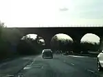 | |||
| Callendar Park, Policy Walls | 55°59′21″N 3°47′15″W | Category C(S) | 50896 | | |||
| 105-111 High Street | 55°59′56″N 3°47′04″W | Category C(S) | 31186 | | |||
| 157-161 High Street | 55°59′56″N 3°46′58″W | Category C(S) | 31194 | | |||
| Offices (Russel And Aitken, A M Cowan) East Side Of King's Court And North Side Of Bean Row At Rear Of 9 Cow Wynd | 55°59′54″N 3°47′02″W | Category B | 31195 | | |||
| Lint Riggs, East Side (Odd Nos) 32-34 High Street And New Market Bar Newmarket Street | 56°00′01″N 3°47′11″W | Category B | 31197 | | |||
| South African War Memorial Newmarket Street | 56°00′02″N 3°47′11″W | Category C(S) | 31203 | | |||
| Cow Wynd Tattie Kirk | 55°59′52″N 3°46′58″W | Category B | 31216 | | |||
| 58, 60 Graham's Road | 56°00′17″N 3°47′04″W | Category B | 31228 | | |||
| Grahamston Church Of Scotland, Bute St | 56°00′25″N 3°46′57″W | Category B | 31231 | | |||
| Union Inn Tamfourhill Road Port Downie | 55°59′58″N 3°49′02″W | Category B | 31233 | | |||
| Canal Inn Canal Street | 56°00′02″N 3°48′53″W | Category C(S) | 31247 | | |||
| Thornhill Road, Saint James' Parish Church Including Halls, Boundary Walls, Gates And Railings | 56°00′20″N 3°46′37″W | Category B | 31253 | | |||
| Parish Church Churchyard | 56°00′00″N 3°47′08″W | Category B | 31168 | | |||
| Royal Bank Buildings 2 High Street And 1 Newmarket Street | 56°00′01″N 3°47′16″W | Category B | 31170 | | |||
| Royal Bank, High Street, 1-9 Kirk Wynd And 27, 29 Manor Street | 55°59′58″N 3°47′04″W | Category B | 31173 | | |||
| 100, 100A High Street | 55°59′58″N 3°47′04″W | Category B | 31174 | | |||
| High Bonnybridge, Broomhill Road, St Helen's Church | 55°59′34″N 3°52′33″W | Category C(S) | 13346 | | |||
| Callendar Park, Callendar House, Stable Block, Including Dovecot, Cobbled Yard, Implement Shed, Boundary Walls And Gates | 55°59′43″N 3°46′13″W | Category B | 46544 | | |||
| 25 And 27 Vicar Street With 4 And 6 Princes Street | 56°00′03″N 3°47′03″W | Category C(S) | 48693 | | |||
| 29 - 35 (Odd Nos) Vicar Street, Vicar Chambers | 56°00′03″N 3°47′03″W | Category B | 48694 | | |||
| 138-140 And 140A High Street | 55°59′57″N 3°47′00″W | Category B | 31183 | | |||
| Royal Bank Buildings 25-29 Newmarket Street And 20 Vicar Street | 56°00′02″N 3°47′05″W | Category B | 31206 | | |||
| Former Post Office (Front Block Only) 45, 47 Vicar Street | 56°00′05″N 3°47′02″W | Category B | 31212 | | |||
| 7 Booth Place | 55°59′53″N 3°47′03″W | Category C(S) | 31218 | | |||
| Callendar Park, Glenbrae Lodge And Gates | 55°59′30″N 3°47′19″W | Category B | 31235 | | |||
| Callendar Park, Callendar House, Stable Court, Including Cobbled Yard | 55°59′43″N 3°46′11″W | Category B | 31239 | | |||
| Callendar Park, Callendar House Mausoleum | 55°59′29″N 3°45′32″W | Category A | 31241 | | |||
| Woodend Farm Hallglen | 55°59′13″N 3°45′46″W | Category C(S) | 31244 | | |||
| Falkirk Parish Churchyard Gate | 56°00′00″N 3°47′10″W | Category B | 31169 | | |||
| 130 High Street | 55°59′57″N 3°47′01″W | Category C(S) | 31181 | | |||
| 132-136A High Street | 55°59′57″N 3°47′00″W | Category C(S) | 31182 | | |||
| 42-46 (Even Nos) Newmarket Street | 56°00′03″N 3°47′05″W | Category C(S) | 48689 | | |||
| Underwood House Including Gatepiers And Boundary Wall | 55°59′21″N 3°55′09″W | Category C(S) | 50223 | | |||
| Tamfourhill Road, Watling Lodge, And Stables Including Gatepiers And Garden Steps | 55°59′53″N 3°49′31″W | Category B | 50226 | | |||
| Hodge Street And Cockburn Street, Erskine Parish Church (Church Of Scotland) Including Church Hall And Boundary Wall | 55°59′52″N 3°47′21″W | Category C(S) | 51113 | | |||
| Rosebank Distillery, Camelon Road, Falkirk | 56°00′08″N 3°48′13″W | Category B | 44184 | | |||
| 148-154 High Street | 55°59′57″N 3°46′57″W | Category B | 31185 | | |||
| St Modan's Church Cochrane Avenue | 55°59′48″N 3°47′10″W | Category B | 31220 | | |||
| Camelon Church Of Scotland, Glasgow Road, Camelon | 56°00′15″N 3°49′03″W | Category C(S) | 31234 | | |||
| Cottage At Lock 11 Forth And Clyde Canal | 56°00′10″N 3°48′12″W | Category C(S) | 31246 | | |||
| Cross Well. High Street | 55°59′57″N 3°47′04″W | Category B | 31177 | 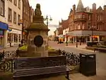 | |||
| Castle Cary | 55°58′31″N 3°56′45″W | Category A | 10519 | 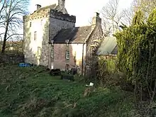 | |||
| Bonnybridge, St Helen's Parish Church, High Street | 56°00′07″N 3°53′33″W | Category C(S) | 49997 | | |||
| Callendar Park, Callendar House, Atrium House (Former Gardener's Cottage), Including Gatepiers | 55°59′46″N 3°45′44″W | Category C(S) | 50224 | | |||
| Hope Street, St Francis-Xavier Rc Church | 56°00′05″N 3°47′19″W | Category B | 51649 | | |||
| 129-131 High Street | 55°59′56″N 3°47′02″W | Category B | 31190 | | |||
| Social Work Department (Former Municipal Bldgs) Newmarket Street | 56°00′03″N 3°47′10″W | Category C(S) | 31207 | | |||
| Christian Institute, 16, 18 Newmarket Street And 1, 3 Glebe Street | 56°00′03″N 3°47′09″W | Category C(S) | 31208 | | |||
| 17 Arnothill, Eriden | 55°59′55″N 3°47′29″W | Category B | 31223 | | |||
| Kilns House Kilns Road | 56°00′07″N 3°47′40″W | Category B | 31225 | | |||
| Royal Hotel High Street | 56°00′01″N 3°47′15″W | Category C(S) | 31171 | | |||
| Falkirk Town Steeple. High Street | 55°59′57″N 3°47′03″W | Category A | 31178 | | |||
| 1 Bank Street And 19, 21 Kirk Wynd, Former Co-Operative Department Store | 56°00′00″N 3°47′03″W | Category C(S) | 51579 | | |||
| 19 And 19A Arnothill, Arnothall, Including Former Stables, Boundary Walls, Railings And Gatepiers | 55°59′57″N 3°47′22″W | Category C(S) | 51613 | | |||
| 113-117 High Street | 55°59′57″N 3°47′04″W | Category B | 31187 | | |||
| 147, 149 High Street, 2 Cow Wynd | 55°59′56″N 3°46′59″W | Category B | 31192 | | |||
| West Church West Bridge Street | 56°00′01″N 3°47′21″W | Category B | 31198 | | |||
| Christ Church Episcopal Church Kerse Lane | 56°00′00″N 3°46′40″W | Category C(S) | 31215 | | |||
| Arnotdale Camelon Road | 56°00′07″N 3°47′51″W | Category B | 31224 | | |||
| Callendar Park, Callendar House | 55°59′40″N 3°46′02″W | Category A | 31236 | | |||
| Callendar Park, Callendar House, Dry Bridge | 55°59′39″N 3°46′32″W | Category C(S) | 31240 | | |||
| Cottage At Lock 9 Forth & Clyde Canal | 56°00′15″N 3°48′00″W | Category C(S) | 31245 | | |||
| 22, 24 Canal Street | 56°00′02″N 3°48′50″W | Category C(S) | 31248 | | |||
| Former Railway Bridge Across River Carron Carron Iron Works | 56°01′15″N 3°47′52″W | Category B | 31250 | | |||
| Slamannan Road Lochgreen Hospital Main Block Boundary Wall And Gatepiers | 55°59′19″N 3°48′12″W | Category B | 31251 | | |||
| Glasgow Road, Camelon, St Mary Of The Angels Roman Catholic Church And Presbytery | 56°00′17″N 3°49′23″W | Category A | 31252 | | |||
| 122 High Street | 55°59′57″N 3°47′02″W | Category C(S) | 31179 | | |||
| 124-128 High Street | 55°59′57″N 3°47′01″W | Category B | 31180 | | |||
| Laurieston House, Including Boundary Wall And Gateway, 2 Polmont Road | 55°59′45″N 3°44′44″W | Category B | 13404 | | |||
| 20 - 24 (Even Nos) Newmarket Street | 56°00′03″N 3°47′08″W | Category C(S) | 48688 | | |||
| 150-154 Grahams Road, The Star Inn | 56°00′26″N 3°47′04″W | Category C(S) | 51119 | | |||
| 119-121 High Street | 55°59′56″N 3°47′03″W | Category C(S) | 31188 | | |||
| 151-155 High Street | 55°59′56″N 3°46′58″W | Category C(S) | 31193 | | |||
| Sheriff Court House Buildings, Hope Street And West Bridge Street | 56°00′02″N 3°47′18″W | Category B | 31200 | | |||
| 9 Hope Street | 56°00′09″N 3°47′20″W | Category B | 31202 | | |||
| Orchard Hotel Kerse Lane | 56°00′00″N 3°46′55″W | Category B | 31214 | | |||
| Mount House Pleasance Gardens | 55°59′53″N 3°47′14″W | Category C(S) | 31219 | | |||
| Hatherley Hotel Arnothill | 55°59′58″N 3°47′49″W | Category B | 31221 | | |||
| Callendar Park, Callendar House Sundial | 55°59′37″N 3°46′04″W | Category B | 31238 | | |||
| Union Canal Tunnel | 55°59′19″N 3°47′35″W | Category B | 31242 | | |||
| Bridge No 62 Union Canal | 55°59′34″N 3°48′03″W | Category B | 31243 | | |||
| Weir Carron Iron Works | 56°01′14″N 3°47′59″W | Category B | 31249 | | |||
| 106-112 High Street | 55°59′58″N 3°47′03″W | Category B | 31176 | | |||
| Obelisk, Marking Site Of Falkirk Battlefield | 55°59′24″N 3°48′59″W | Category B | 10521 | | |||
| Craigieburn Farmhouse Lochgreen Road | 55°58′57″N 3°49′48″W | Category B | 10523 | | |||
| 42 And 44 Vicar Street, Firkins Bar And 1-9 (Odd Numbers) Melville Street | 56°00′05″N 3°47′05″W | Category C(S) | 48690 | | |||
| 52 - 58 (Even Nos) Vicar Street | 56°00′06″N 3°47′05″W | Category B | 48692 | | |||
| Laurieston, Mumrills Road, Mumrills House Including Courtyard/Garden Walls And Outbuildings | 55°59′50″N 3°44′12″W | Category B | 50158 | | |||
| Tamfourhill Road, Oakdene, Including Gatepiers And Gate | 55°59′52″N 3°49′11″W | Category B | 50225 | | |||
| Callendar Park, Wellhead | 55°59′25″N 3°47′09″W | Category C(S) | 50897 | | |||
| 102-104 Grahams Road, Former Oddfellows Hall | 55°59′57″N 3°47′22″W | Category C(S) | 51542 | | |||
| 123-127 High Street Falkirk Herald Building | 55°59′56″N 3°47′03″W | Category C(S) | 31189 | | |||
| Public Library Hope Street | 56°00′06″N 3°47′19″W | Category B | 31201 | | |||
| Mayfield, Maggie Woods Loan And Arnothill Lane | 55°59′58″N 3°47′52″W | Category B | 31222 | | |||
| Red Lion Inn Bankside At Bainsford Bridge | 56°00′40″N 3°47′08″W | Category C(S) | 31232 | | |||
| Callendar Park, Callendar House, Small Bridge On South Axis Of House | 55°59′38″N 3°46′04″W | Category B | 31237 | | |||
| 86, 88 High Street And 2 Kirk Wynd | 55°59′58″N 3°47′06″W | Category C(S) | 31172 | | |||
| 102, 104 High Street | 55°59′58″N 3°47′04″W | Category B | 31175 | | |||
| Glen Bridge | 55°59′02″N 3°47′18″W | Category B | 10522 | | |||
| Callendar Park, Callendar House, Factor's House | 55°59′45″N 3°46′13″W | Category B | 46545 | | |||
| 46 - 50 (Even Nos) Vicar Street | 56°00′06″N 3°47′05″W | Category C(S) | 48691 | | |||
| Bonnybridge, Bonnyside Road, Bonnyside House | 55°59′52″N 3°52′13″W | Category C(S) | 49998 | | |||
| Falkirk, Laurieston, Mumrills Road, Mumrills Farm | 55°59′50″N 3°44′09″W | Category B | 50159 | | |||
| Callendar Park, Kennels | 55°59′32″N 3°47′14″W | Category C(S) | 50894 | |
Key
The scheme for classifying buildings in Scotland is:
- Category A: "buildings of national or international importance, either architectural or historic; or fine, little-altered examples of some particular period, style or building type."[1]
- Category B: "buildings of regional or more than local importance; or major examples of some particular period, style or building type, which may have been altered."[1]
- Category C: "buildings of local importance; lesser examples of any period, style, or building type, as originally constructed or moderately altered; and simple traditional buildings which group well with other listed buildings."[1]
In March 2016 there were 47,288 listed buildings in Scotland. Of these, 8% were Category A, and 50% were Category B, with the remaining 42% being Category C.[2]
Notes
- Sometimes known as OSGB36, the grid reference (where provided) is based on the British national grid reference system used by the Ordnance Survey.
• "Guide to National Grid". Ordnance Survey. Retrieved 12 December 2007.
• "Get-a-map". Ordnance Survey. Retrieved 17 December 2007. - Historic Environment Scotland assign a unique alphanumeric identifier to each designated site in Scotland, for listed buildings this always begins with "LB", for example "LB12345".
References
- All entries, addresses and coordinates are based on data from Historic Scotland. This data falls under the Open Government Licence
- "What is Listing?". Historic Environment Scotland. Retrieved 29 May 2018.
- Scotland's Historic Environment Audit 2016 (PDF). Historic Environment Scotland and the Built Environment Forum Scotland. pp. 15–16. Retrieved 29 May 2018.
This article is issued from Wikipedia. The text is licensed under Creative Commons - Attribution - Sharealike. Additional terms may apply for the media files.