List of listed buildings in Fordoun, Aberdeenshire
List
| Name | Location | Date Listed | Grid Ref. [note 1] | Geo-coordinates | Notes | LB Number [note 2] | Image |
|---|---|---|---|---|---|---|---|
| Store Behind Drumtochty Arms Hotel Off High Street Auchenblae | 56°53′59″N 2°26′58″W | Category C(S) | 10722 |  | |||
| Brae View Inverurie Street Auchenblae | 56°54′02″N 2°27′04″W | Category C(S) | 10725 | | |||
| Denmill Fyfe And Rennies House Burnett Street Auchenblae | 56°53′49″N 2°26′59″W | Category C(S) | 10735 | | |||
| Clatterin Bridge Over Devilly Burn | 56°53′38″N 2°33′05″W | Category B | 10741 | | |||
| W M Lindsay's Kintore Street Auchenblae | 56°53′58″N 2°26′59″W | Category C(S) | 10746 | | |||
| Mr Begg's House Market Square Auchenblae | 56°53′58″N 2°27′01″W | Category C(S) | 10747 | | |||
| The Bruce Fountain High Street Auchenblae | 56°53′59″N 2°27′01″W | Category C(S) | 10751 | | |||
| The Willows And Scott's Crafts, Kintore Street Auchenblae | 56°53′55″N 2°26′57″W | Category B | 10699 | | |||
| Noranside Kintore Street Auchenblae | 56°53′57″N 2°26′59″W | Category C(S) | 10703 | | |||
| Argyle House Kintore Street Auchenblae | 56°53′57″N 2°27′00″W | Category B | 10704 | | |||
| Kincardine Castle | 56°51′58″N 2°32′27″W | Category B | 6770 | | |||
| Monboddo Street, Auchenblae Public Hall | 56°53′53″N 2°27′00″W | Category B | 49583 | | |||
| Mossgiel High Street Auchenblae | 56°53′59″N 2°27′00″W | Category C(S) | 10721 | | |||
| Former Parish School Auchenblae | 56°53′47″N 2°27′06″W | Category C(S) | 10728 | | |||
| Jacks Bank House Off Inverurie Street Auchenblae | 56°54′06″N 2°27′01″W | Category C(S) | 10737 | | |||
| Goyle View Inverurie Street Auchenblae | 56°54′08″N 2°27′01″W | Category C(S) | 10739 | | |||
| Auchcairnie Farmhouse | 56°52′12″N 2°30′39″W | Category B | 10740 | | |||
| Dr D Wiseman's Kintore Street Auchenblae | 56°53′57″N 2°26′57″W | Category C(S) | 10743 | | |||
| Cedar House Kintore Street Auchenblae | 56°53′58″N 2°26′57″W | Category B | 10745 | | |||
| Strathview Market Square Auchenblae | 56°53′58″N 2°27′01″W | Category C(S) | 10748 | | |||
| Marybank High Street Auchenblae | 56°54′01″N 2°27′04″W | Category C(S) | 10756 | | |||
| Ryehill Inverurie Street Auchenblae | 56°54′03″N 2°27′04″W | Category C(S) | 10759 | | |||
| Norwood Inverurie Street Auchenblae | 56°54′06″N 2°27′03″W | Category C(S) | 10765 | | |||
| Ross Cottage Inverurie Street Auchenblae | 56°54′06″N 2°27′02″W | Category C(S) | 10775 | | |||
| Phesdo House | 56°52′15″N 2°32′00″W | Category A | 9646 | | |||
| Pitremnie Mill | 56°53′01″N 2°26′50″W | Category C(S) | 9651 | | |||
| House Of Redhall | 56°52′55″N 2°25′23″W | Category B | 9652 | | |||
| Craignoston Bridge Over Burn Of Garrol | 56°52′07″N 2°34′09″W | Category C(S) | 9663 | | |||
| Ashley Cottages Inverurie Street Auchenblae | 56°54′06″N 2°27′02″W | Category C(S) | 49219 | | |||
| Chestnut House High Street Auchenblae | 56°54′00″N 2°27′01″W | Category C(S) | 10719 | | |||
| Fordoun Parish Church Manse Including Steading Auchenblae | 56°53′45″N 2°27′04″W | Category B | 10727 | | |||
| Mr Mcgregors' Kintore Street Auchenblae | 56°53′57″N 2°26′58″W | Category C(S) | 10744 | | |||
| Mrs Marson's High Street Auchenblae | 56°54′00″N 2°27′03″W | Category C(S) | 10753 | | |||
| Glen View Off Inverurie Street Auchenblae | 56°54′03″N 2°27′04″W | Category C(S) | 10758 | | |||
| Peaty's House Inverurie Street Auchenblae | 56°54′03″N 2°27′03″W | Category C(S) | 10760 | | |||
| Shamrock Cottage Inverurie Street Auchenblae | 56°54′06″N 2°27′03″W | Category C(S) | 10764 | | |||
| Kobe House Inverurie Street Auchenblae | 56°54′02″N 2°27′02″W | Category C(S) | 10770 | | |||
| Fern Lea Inverurie Street Auchenblae | 56°54′04″N 2°27′02″W | Category B | 10773 | | |||
| Adriatic House Monboddo Street Auchenblae | 56°53′52″N 2°26′59″W | Category B | 10697 | | |||
| Gowan Lee Kintore Street Auchenblae | 56°53′58″N 2°27′01″W | Category C(S) | 10706 | | |||
| Mill Of Kincardine - Bridge Over Devilly Burn | 56°52′22″N 2°32′22″W | Category C(S) | 9642 | | |||
| Monboddo House | 56°53′41″N 2°25′15″W | Category B | 9643 | | |||
| Auchenblae High Street, K6 Telephone Kiosk | 56°53′59″N 2°27′01″W | Category B | 13002 | | |||
| St Palladuis Chapel Within Fordoun Parish Churchyard Auchenblae | 56°53′47″N 2°27′04″W | Category B | 10726 | 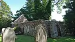 | |||
| 3. Denmill Cottage Burnett Street Auchenblae | 56°53′49″N 2°27′01″W | Category C(S) | 10733 | | |||
| Mrs Ritchie's High Street Auchenblae | 56°54′00″N 2°27′02″W | Category C(S) | 10754 | | |||
| Ingleside High Street Auchenblae | 56°54′01″N 2°27′03″W | Category C(S) | 10755 | | |||
| Woodstock And J V Nicoll's House Inverurie Street Auchenblae | 56°54′05″N 2°27′03″W | Category C(S) | 10763 | | |||
| Rose Cottage & Rosebank Inverurie Street Auchenblae | 56°54′07″N 2°27′03″W | Category C(S) | 10766 | | |||
| Rowan Bank Kintore Street Auchenblae | 56°53′57″N 2°27′00″W | Category C(S) | 10705 | | |||
| Millarton High Street Auchenblae | 56°54′01″N 2°27′04″W | Category C(S) | 10717 | | |||
| Cranwell House High Street Auchenblae | 56°54′00″N 2°27′00″W | Category C(S) | 10720 | | |||
| Gean Cottage Inverurie Street Auchenblae | 56°54′02″N 2°27′04″W | Category C(S) | 10724 | | |||
| The Hollies High Street Auchenblae | 56°53′59″N 2°27′02″W | Category B | 10749 | | |||
| Westfield Inverurie Street Auchenblae | 56°54′04″N 2°27′02″W | Category C(S) | 10772 | | |||
| Fordoun House | 56°53′01″N 2°26′25″W | Category B | 9635 | | |||
| Phesdo House Stables | 56°52′22″N 2°31′59″W | Category B | 9647 | | |||
| Pitarrow Dovecot | 56°51′54″N 2°27′01″W | Category B | 9650 | | |||
| Kirkton Farmhouse Auchenblae | 56°53′47″N 2°27′08″W | Category B | 10729 | | |||
| Den Mill Burnett Street Auchenblae | 56°53′50″N 2°27′01″W | Category B | 10734 | | |||
| 5. Beech Villa Burnett Street Auchenblae | 56°53′50″N 2°26′59″W | Category C(S) | 10736 | | |||
| Townhead Inverurie Street Auchenblae | 56°54′08″N 2°27′02″W | Category C(S) | 10738 | | |||
| Distillery House Auchenblae | 56°53′58″N 2°27′08″W | Category C(S) | 10750 | | |||
| Monaltrie Inverurie Street Auchenblae | 56°54′03″N 2°27′04″W | Category C(S) | 10757 | | |||
| Cammock House Inverurie Street Auchenblae | 56°54′04″N 2°27′03″W | Category C(S) | 10761 | | |||
| Alexander Brown's Inverurie Street Auchenblae | 56°54′07″N 2°27′03″W | Category C(S) | 10767 | | |||
| Auchenblae Village Fordoun Parish Church Auchenblae Village | 56°53′48″N 2°27′05″W | Category B | 10691 | 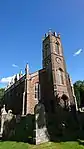 | |||
| 6. Douglas, Burnett Street Auchenblae | 56°53′51″N 2°27′00″W | Category C(S) | 10695 | | |||
| 3. Monboddo Street Auchenblae | 56°53′54″N 2°26′55″W | Category B | 10698 | | |||
| Drumtochty Castle - East Lodge | 56°54′26″N 2°28′18″W | Category C(S) | 9633 | | |||
| Bridge Of Mondynes Over Bervie Water | 56°54′28″N 2°21′34″W | Category B | 9645 | | |||
| Phesdo House Dovecot | 56°52′24″N 2°32′09″W | Category B | 9648 | | |||
| Auchenblae, Mid Blairs Farm, Horsemill, Steading And Bothy | 56°54′56″N 2°25′14″W | Category C(S) | 50009 | | |||
| Kintore Cottage 1-2 Off High Street Auchenblae | 56°54′00″N 2°26′55″W | Category B | 10723 | | |||
| Balmashanner Burnett Street Auchenblae | 56°53′47″N 2°26′57″W | Category B | 10732 | | |||
| Holly Cottage High Street Auchenblae | 56°53′59″N 2°27′02″W | Category C(S) | 10752 | | |||
| Parkview Inverurie Street Auchenblae | 56°54′05″N 2°27′03″W | Category C(S) | 10762 | | |||
| Mr Fraser's Kintore Street Auchenblae | 56°53′56″N 2°26′58″W | Category C(S) | 10700 | | |||
| Thistle Inn Kintore Street Auchenblae | 56°53′56″N 2°26′59″W | Category B | 10702 | | |||
| C And E Kinty Kintore Street Auchenblae | 56°53′56″N 2°26′56″W | Category C(S) | 10707 | | |||
| St Palladius Episcopal Church, Drumtochty | 56°54′33″N 2°28′55″W | Category A | 9634 | | |||
| Mill Of Kincardine Farmhouse | 56°52′26″N 2°32′18″W | Category B | 9637 | | |||
| House Of Redhall Lodge | 56°52′51″N 2°25′27″W | Category C(S) | 9653 | | |||
| Drumtochty Castle | 56°54′39″N 2°29′40″W | Category A | 9664 | | |||
| Glencairn High Street Auchenblae | 56°54′01″N 2°27′01″W | Category C(S) | 10718 | | |||
| Fordoun School House Auchenblae | 56°53′49″N 2°27′10″W | Category C(S) | 10730 | | |||
| Fordoun School Auchenblae | 56°53′50″N 2°27′08″W | Category C(S) | 10731 | | |||
| Luther Bank House Kintore Street Auchenblae | 56°53′56″N 2°26′56″W | Category C(S) | 10742 | | |||
| Myrtle Cottage Inverurie Street Auchenblae | 56°54′07″N 2°27′03″W | Category C(S) | 10768 | | |||
| Lilian House Inverurie Street Auchenblae | 56°54′02″N 2°27′02″W | Category C(S) | 10769 | | |||
| Roseleigh Inverurie Street Auchenblae | 56°54′03″N 2°27′02″W | Category C(S) | 10771 | | |||
| Auchter House Inverurie Street Auchenblae | 56°54′06″N 2°27′02″W | Category C(S) | 10774 | | |||
| Fourdoun Parish Churchyard Auchenblae | 56°53′48″N 2°27′03″W | Category C(S) | 10692 | | |||
| Clydesdale Bank Monboddo Street Auchenblae | 56°53′55″N 2°26′59″W | Category B | 10696 | | |||
| Thistle Cottage Off Kintore Street Auchenblae | 56°53′56″N 2°27′00″W | Category C(S) | 10701 | | |||
| Drumtochty Castle Stables | 56°54′35″N 2°29′54″W | Category B | 9632 | | |||
| Bridge Of Keir Over Bervie Water | 56°52′18″N 2°23′28″W | Category B | 9636 | | |||
| Mill Of Mondynes | 56°54′12″N 2°21′48″W | Category C(S) | 9644 | | |||
| Pitarrow Bridge Over Luther Water | 56°51′55″N 2°27′02″W | Category C(S) | 9649 | | |||
| Clatterin Bridge Limekiln | 56°53′37″N 2°33′07″W | Category C(S) | 9662 | |
Key
The scheme for classifying buildings in Scotland is:
- Category A: "buildings of national or international importance, either architectural or historic; or fine, little-altered examples of some particular period, style or building type."[1]
- Category B: "buildings of regional or more than local importance; or major examples of some particular period, style or building type, which may have been altered."[1]
- Category C: "buildings of local importance; lesser examples of any period, style, or building type, as originally constructed or moderately altered; and simple traditional buildings which group well with other listed buildings."[1]
In March 2016 there were 47,288 listed buildings in Scotland. Of these, 8% were Category A, and 50% were Category B, with the remaining 42% being Category C.[2]
Notes
- Sometimes known as OSGB36, the grid reference (where provided) is based on the British national grid reference system used by the Ordnance Survey.
• "Guide to National Grid". Ordnance Survey. Retrieved 2007-12-12.
• "Get-a-map". Ordnance Survey. Retrieved 2007-12-17. - Historic Environment Scotland assign a unique alphanumeric identifier to each designated site in Scotland, for listed buildings this always begins with "LB", for example "LB12345".
References
- All entries, addresses and coordinates are based on data from Historic Scotland. This data falls under the Open Government Licence
- "What is Listing?". Historic Environment Scotland. Retrieved 29 May 2018.
- Scotland's Historic Environment Audit 2016 (PDF). Historic Environment Scotland and the Built Environment Forum Scotland. pp. 15–16. Retrieved 29 May 2018.
This article is issued from Wikipedia. The text is licensed under Creative Commons - Attribution - Sharealike. Additional terms may apply for the media files.