List of listed buildings in Glasgow/1
List
| Name | Location | Date Listed | Grid Ref. [note 1] | Geo-coordinates | Notes | LB Number [note 2] | Image |
|---|---|---|---|---|---|---|---|
| 10-28 (Even Nos) Cleveden Gardens With Boundary Walls, Gatepiers To Road And Gatepiers Flanking Entrances | 55°53′03″N 4°17′58″W | Category B | 44654 |  | |||
| 2-12A (Inclusive Nos) Princes Terrace, Prince Albert Road, With Gatepiers And Railings To Princes Terrace Lane | 55°52′37″N 4°18′06″W | Category B | 44595 | 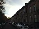 | |||
| 315-349 (Odd Nos) Sauchiehall Street, 148, 150 Holland Street | 55°51′56″N 4°15′55″W | Category B | 43904 | | |||
| 20 Dykebar Avenue And 17 Foxbar Drive, Knightswood Community Youth Centre | 55°53′20″N 4°21′26″W | Category C(S) | 43117 | | |||
| 42 Lincoln Avenue, Corpus Christi Roman Catholic Church And Presbytery With Railings And Boundary Wall | 55°53′13″N 4°21′03″W | Category C(S) | 43118 | | |||
| 833-861 (Odd Nos) Crow Road, Anniesland Court | 55°53′27″N 4°19′31″W | Category A | 43034 | 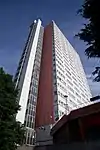 | |||
| 206 Knightswood Road, Knightswood Cross, St Ninian's Roman Catholic Church And Church Hall With Boundary Walls, Gates And Gatepiers | 55°53′43″N 4°20′27″W | Category B | 43038 | | |||
| 212, 214 Newlands Road, Former New Cathcart Church Including Hall, Piers And Railings | 55°49′04″N 4°15′52″W | Category B | 33950 | | |||
| Pleasance Street, Greenview Street, Clock Tower | 55°49′32″N 4°17′39″W | Category B | 33951 | | |||
| 1039 Pollokshaws Road, Corona Bar | 55°49′53″N 4°16′44″W | Category C(S) | 33952 | | |||
| Shawhill Road, St Mary Immaculate Rc Church And Presbytery | 55°49′34″N 4°17′32″W | Category B | 33965 | | |||
| 42 Spean Street, Scottish Power Building Including Access Bridge | 55°49′16″N 4°15′58″W | Category B | 33967 | | |||
| 6-76 (Even Nos) Springhill Gardens And 912-924 (Even Nos) Pollokshaws Road | 55°50′00″N 4°16′35″W | Category C(S) | 33968 | | |||
| 200 Thornliebank Road, Eastwood Cemetery | 55°48′46″N 4°18′39″W | Category B | 33969 | | |||
| 107-141 (Odd Nos) Saltmarket And 3-7 (Odd Nos) Steel Street | 55°51′17″N 4°14′43″W | Category B | 33972 | | |||
| 9 Armadale Street And Roselea Drive, Dennistoun Central Church Of Scotland | 55°51′32″N 4°13′01″W | Category B | 33885 | | |||
| 6 Broompark Circus Including Gatepiers | 55°51′45″N 4°13′23″W | Category B | 33887 | | |||
| 23-49 (Odd Nos) Broompark Drive | 55°51′41″N 4°13′21″W | Category B | 33889 | | |||
| 2A Craigpark, Dennistoun Library | 55°51′33″N 4°13′17″W | Category B | 33893 | | |||
| 1-12 (Inclusive Numbers) Seton Terrace | 55°51′33″N 4°13′22″W | Category C(S) | 33905 | | |||
| 23 Westercraigs Including Boundary Wall And Piers | 55°51′36″N 4°13′26″W | Category C(S) | 33908 | | |||
| 380 Clarkston Road, Former Toledo Cinema | 55°48′35″N 4°16′20″W | Category B | 33920 | | |||
| 64, 66, 68 Greenview Street | 55°49′37″N 4°17′43″W | Category C(S) | 33923 | | |||
| 2 Langside Drive, 37 Riverside Road, Newlands South Church And Hall | 55°49′20″N 4°16′43″W | Category B | 33934 | 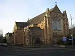 | |||
| 14 Langside Drive And Corrour Road, Towerdene Including Gatepiers And Perimeter Walls | 55°49′15″N 4°16′42″W | Category B | 33935 | | |||
| 52-54 (Even Nos) Langside Drive | 55°48′55″N 4°16′43″W | Category A | 33936 | | |||
| 78, 80 Merrylee Road, Merrylee Parish Church And Halls, Including Gates And Railings | 55°48′50″N 4°16′30″W | Category B | 33940 | | |||
| Whitemoss Avenue, Muirend Station | 55°48′36″N 4°16′26″W | Category B | 33942 | 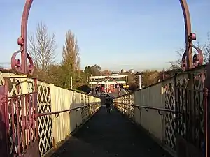 | |||
| 97-113 (Odd Nos) Greenhead Street 2-12 (Even Nos) James Street, 100 Tullis Street | 55°50′51″N 4°13′52″W | Category B | 33846 | | |||
| 117-127 (Odd Nos) Greenhead Street, 91-101 (Odd Nos) Tullis Street | 55°50′47″N 4°13′50″W | Category B | 33847 | | |||
| 23 Landressy Street Bridgeton Public Library | 55°50′55″N 4°13′40″W | Category B | 33850 |  | |||
| 577-621 (Odd Nos) London Road, 2-4 (Even Nos) Kerr Street And 3-5 (Odd Nos) Orr Street, Former Bridgeton Cross Station And Tenements | 55°50′58″N 4°13′37″W | Category B | 33853 | | |||
| 20 Baldinnie Road And Wardie Road Blairtummock House Including Walled Garden And Garden House | 55°51′55″N 4°07′06″W | Category B | 33864 | | |||
| 358 Carntynehall Road, High Carntyne Church Including Railings | 55°51′41″N 4°10′50″W | Category B | 33865 |  | |||
| 2270-2288 (Even Nos) Gartloch Road, Gartloch Hospital, Gartloch Cottages | 55°52′52″N 4°05′46″W | Category B | 33873 | | |||
| Robroyston Road, Wallace Monument | 55°53′52″N 4°11′09″W | Category B | 33874 |  | |||
| 1-18 (Inclusive Nos) Walmer Crescent And 1, 3, 5A, 5B Cessnock Street | 55°51′07″N 4°17′48″W | Category A | 33876 |  | |||
| 637-647 (Odd Nos) Alexandra Parade And 81 Alexandra Park Street | 55°51′48″N 4°12′41″W | Category B | 33878 | | |||
| 1-16 (Inc Nos) Annfield Place, 1 And 2B Craigpark, Including Garden Walls To South | 55°51′31″N 4°13′21″W | Category B | 33884 | | |||
| 167-205 (Odd Nos) Wilton Street | 55°52′43″N 4°16′46″W | Category B | 33786 | | |||
| 4-42 (Even Nos) Garry Street, 29-31 (Odd Nos) Spean Street And 162-172 (Even Nos) Holmlea Road | 55°49′20″N 4°15′46″W | Category C(S) | 33804 | | |||
| 1-14 (Inclusive Numbers) Hampden Terrace And 991-1015 (Odd Nos) Cathcart Road, Including Boundary Walls | 55°49′40″N 4°15′27″W | Category C(S) | 33805 | 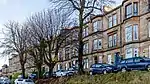 | |||
| Holmlea Road, New Bridge | 55°49′05″N 4°15′42″W | Category B | 33806 | | |||
| 352-362 (Even Nos) Holmlea Road, Tulloch Street, Spean Street, Holmlea Primary School Including Janitor's Lodge And Railings | 55°49′09″N 4°15′41″W | Category B | 33807 | 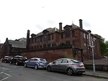 | |||
| 149-165 (Odd Nos) Stanmore Road Including Boundary Walls | 55°49′41″N 4°15′11″W | Category B | 33809 | 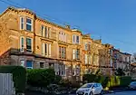 | |||
| 309-341 (Odd Nos) Abercromby Street, Burial Ground | 55°51′03″N 4°13′45″W | Category B | 33811 | | |||
| 26-30 (Even Nos) And 42 Bain Street, 15-25 (Odd Nos) Gibson Street (Calton Street) 73, 99, 99A Moncur Street | 55°51′18″N 4°14′08″W | Category B | 33813 | 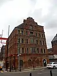 | |||
| 142, 144 Bell Street And 18 Watson Street | 55°51′25″N 4°14′30″W | Category C(S) | 33816 | 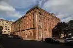 | |||
| 5-9 (Odd Nos) Bridgeton Cross, 1-11 (Odd Nos) Dalmarnock Road | 55°50′56″N 4°13′34″W | Category C(S) | 33819 | | |||
| 32-38A Bridgeton Cross | 55°50′57″N 4°13′38″W | Category B | 33820 | | |||
| Glasgow Green At Greenhead Street, James Martin Memorial Fountain And Canopy | 55°50′57″N 4°13′59″W | Category B | 33839 |  | |||
| 506 And 548 Bilsland Drive, Staff Houses, 490, 492, 500, 502, 554, 556, 562 And 568 Bilsland Drive, Ruchill Hospital Former Staff Houses And Cottages | 55°53′19″N 4°15′55″W | Category C(S) | 33748 | | |||
| 520 Bilsland Drive, Ruchill Hospital, Ward Pavilions | 55°53′12″N 4°16′08″W | Category C(S) | 33749 | | |||
| 165 Glenhead Street, 24 Kippen Street, And Buckley Street, Parkhouse School, Janitor's House With Gatepiers, Retaining Walls And Railings | 55°53′26″N 4°14′37″W | Category B | 33751 | | |||
| 50-56 (Even Nos) Ruchill Street | 55°53′13″N 4°16′56″W | Category C(S) | 33752 | 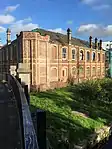 | |||
| 1-15 (Inclusive Nos) Botanic Crescent | 55°52′50″N 4°17′16″W | Category B | 33754 | | |||
| 1-11 (Inclusive Nos) Doune Gardens | 55°52′42″N 4°16′47″W | Category B | 33759 | | |||
| 95 Hotspur Street, Kelbourne School And 109 Hotspur Street, Janitor's House, Gatepiers And Railings | 55°53′01″N 4°17′12″W | Category C(S) | 33767 | | |||
| 4-13 (Inclusive Nos) Kelvin Drive And Gatepiers | 55°52′49″N 4°17′11″W | Category B | 33768 | | |||
| 10 Moncrieff Street, Braid Square, North Woodside Baths And Washhouse | 55°52′18″N 4°15′49″W | Category B | 33775 | | |||
| St George's Cross, Equestrian Statue | 55°52′16″N 4°16′07″W | Category C(S) | 33778 | 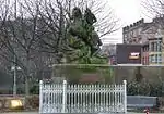 | |||
| 67-107 (Odd Nos) Wilton Street And Railings | 55°52′40″N 4°16′28″W | Category B | 33784 | | |||
| 143-165 (Odd Nos) Wilton Street | 55°52′42″N 4°16′41″W | Category B | 33785 | | |||
| 345-349, 353, 357, 359, 363 Pollokshaws Road, 7 Butterfield Place | 55°50′31″N 4°15′49″W | Category B | 33697 | | |||
| 19 Tresta Road, Western Necropolis Including Boundary Walls, Crematorium, Gatepiers, Gates And Railings, Jewish Prayer House, War Memorial And South African War Memorial | 55°54′02″N 4°16′55″W | Category B | 33734 | | |||
| 284-288 (Even Nos) Ashgill Road, Chirnside Primary School And Janitor`S House | 55°53′32″N 4°14′37″W | Category B | 33735 | | |||
| 426 Balmore Road, Hodge Court, Former Possil School Gymnasium Including Gatepiers And Boundary Walls | 55°53′29″N 4°15′30″W | Category C(S) | 33742 | | |||
| 479 Balmore Road, Former Possil Station | 55°53′31″N 4°15′36″W | Category C(S) | 33744 | 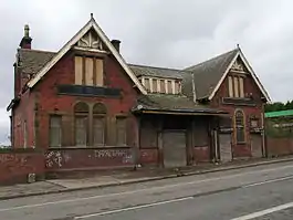 | |||
| 520 Bilsland Drive, Ruchill Hospital Administration Block, Kitchen Block, Enquiry Block, Clearing House, Mortuary Block, Main Stairway And Stables | 55°53′12″N 4°16′08″W | Category B | 33746 | | |||
| 520 Bilsland Drive, Ruchill Hospital Gate Lodges | 55°53′19″N 4°15′58″W | Category C(S) | 33747 | | |||
| 1281 London Road And 719, 721 Springfield Road | 55°50′53″N 4°12′08″W | Category C(S) | 33640 | | |||
| 679 Old Shettleston Road, Eastbank Parish Church And Hall With Railings And Gatepiers | 55°51′07″N 4°09′45″W | Category B | 33641 | 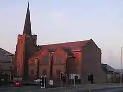 | |||
| 591 Tollcross Road, Wellshot Road, Former Tollcross House Stables, Now East Lodge, Tollcross Park | 55°50′48″N 4°10′34″W | Category C(S) | 33651 | | |||
| 1-45 (Odd Nos) Tollcross Road And 2-40 (Even Nos) Westmuir Street | 55°51′04″N 4°11′45″W | Category C(S) | 33652 | | |||
| 1088 Tollcross Road, Tollcross Central Church Churchyard,Boundary Walls And Gatepiers | 55°50′34″N 4°10′23″W | Category B | 33654 | | |||
| 1134 Tollcross Road And Causewayside Street, Victoria Tollcross Church And Hall, Gates, Gatepiers And Railings | 55°50′34″N 4°10′13″W | Category C(S) | 33655 | | |||
| 1, 15, 16, 17 Daldowie Crematorium | 55°49′56″N 4°06′51″W | Category B | 33667 | | |||
| 2405 London Road Kenmuir Mount Vernon Church Including Halls, Gates And Gatepiers (Church Of Scotland) | 55°50′18″N 4°08′57″W | Category B | 33671 | .jpg.webp) | |||
| 10 Muirhead Road, Ballieston | 55°50′54″N 4°06′31″W | Category B | 33674 | | |||
| 1651 Shettleston Road, St Paul's Roman Catholic Church | 55°51′03″N 4°09′09″W | Category B | 33678 | | |||
| 378-390 (Even Nos) Cathcart Road And 153 Coplaw Street, Savings Bank Buildings | 55°50′22″N 4°15′25″W | Category C(S) | 33686 | 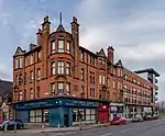 | |||
| 221 Crookston Road, Ross Hall (Original Block) | 55°50′21″N 4°21′52″W | Category B | 33593 | | |||
| 1-10 Hillington Park Circus | 55°50′51″N 4°20′50″W | Category C(S) | 33598 | | |||
| Ralston Avenue 97 (Dunard) And 101 (Raeberry), Including Boundary Walls And Gatepiers | 55°50′31″N 4°22′07″W | Category B | 33605 | | |||
| Viaduct At Salterland | 55°48′45″N 4°22′31″W | Category B | 33608 | | |||
| Midwharf Street And North Canalbank Street, Forth And Clyde Canal, Railway Swing Bridge Including Stone Platforms And Revetments | 55°52′20″N 4°15′05″W | Category B | 33616 | | |||
| 201 Springburn Road, Sighthill Cemetery, Including Lodge And Gatepiers And Gateway At Keppochill Road | 55°52′46″N 4°14′16″W | Category B | 33623 | | |||
| 48 Avenue Street, 190, 210 Fielden Street And 35, 51 Barrowfield Street | 55°51′00″N 4°12′59″W | Category B | 33626 | | |||
| 146 Crownpoint Road | 55°51′08″N 4°13′21″W | Category B | 33629 | | |||
| 1264 Gallowgate, Eastern Necropolis, Including Lodge Gateway And Boundary Walls | 55°51′09″N 4°12′06″W | Category B | 33633 | | |||
| 52-64 (Even Nos) Helenvale Street | 55°51′00″N 4°11′49″W | Category C(S) | 33635 | | |||
| 252, 254, 256 Paisley Road West And 2, 4, 6, Harvie Street | 55°51′09″N 4°17′22″W | Category B | 33527 | | |||
| 17 Milnpark Street With Elevation To Seaward Street, Kinning Park Pumping Station | 55°51′06″N 4°16′40″W | Category B | 33537 | | |||
| 104-118 Tradeston Street (Even Nos), Return Elevation To Cook Street Former Clydesdale Paint, Colour And Oil Works | 55°51′06″N 4°15′52″W | Category B | 33538 | | |||
| 52 First Gardens, Hazelwood House | 55°50′39″N 4°18′43″W | Category B | 33574 | | |||
| 28-68 (Inclusive Nos) Ibrox Terrace | 55°51′09″N 4°18′11″W | Category B | 33576 | | |||
| 135 Cardonald Place Road, Cardonald Place Farmhouse And Steading | 55°50′31″N 4°21′22″W | Category C(S) | 33587 | | |||
| 553-609 (Odd Nos) Shields Road, 271-277 (Odd Nos) Albert Drive, 86-88 (Even Nos) Leslie Street, Knowe Terrace Including Gatepiers And Railings | 55°50′33″N 4°16′34″W | Category B | 33479 | | |||
| 110 Springkell Avenue, Kelmscott, Including Boundary Walls And Gatepiers | 55°50′23″N 4°18′05″W | Category B | 33485 | | |||
| 124 Springkell Avenue, Benefrey, Including Boundary Walls And Gatepiers | 55°50′21″N 4°18′17″W | Category A | 33486 | | |||
| 21, 23, 25 Carlton Court | 55°51′15″N 4°15′27″W | Category B | 33498 | | |||
| 600-614 Eglinton Street (Even Nos), 26 Gourock Street | 55°50′40″N 4°15′45″W | Category B | 33510 | | |||
| 28 And 58 Lorne Street, Lorne Street School And Janitor's House | 55°51′13″N 4°17′17″W | Category B | 33517 | 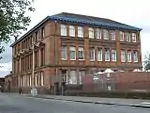 | |||
| 17-57 (Odd Nos) Fotheringay Road | 55°50′14″N 4°16′55″W | Category B | 33405 | | |||
| 8 Leslie Road, Including Conservatory Boundary Walls And Gatepiers | 55°50′29″N 4°16′45″W | Category B | 33417 | 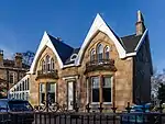 | |||
| 16, 18 Leven Street And 251 Kenmure Street | 55°50′23″N 4°16′23″W | Category B | 33420 | | |||
| 30-50 (Even Nos) Leven Street, 645-661 (Odd Nos) Shields Road And 45-51 (Odd Nos) Melville Street, Including Railings | 55°50′26″N 4°16′37″W | Category C(S) | 33421 | 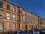 | |||
| 1, 13, 15 Maxwell Road And 320-328 (Even Nos) Pollokshaws Road | 55°50′34″N 4°15′47″W | Category B | 33426 | 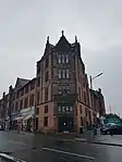 | |||
| 336-362 (Even Nos) Maxwell Road, 459 Shields Road | 55°50′41″N 4°16′30″W | Category B | 33427 | | |||
| 229 Nithsdale Road, Allerly, Including Boundary Walls And Gatepiers | 55°50′34″N 4°17′34″W | Category B | 33442 | | |||
| 84-112 (Even Nos) Nithsdale Road, 256-280 (Even Nos) Darnley Street And 281-289 (Odd Nos) Kenmure Street | 55°50′19″N 4°16′27″W | Category B | 33444 | 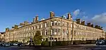 | |||
| 2060 Pollokshaws Road, Pollok House Including Service Court, Forecourt, Garden Walling And Pavilions | 55°49′39″N 4°19′04″W | Category A | 33455 | 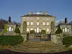 | |||
| 59 St Andrew's Drive, Ardenlea, Including Boundary Walls And Gatepiers | 55°50′38″N 4°17′16″W | Category B | 33462 | | |||
| Carmunnock, 68, 70 Busby Road, Miln Flat | 55°47′15″N 4°14′35″W | Category C(S) | 33315 | | |||
| Carmunnock, 8 & 8A Kirk Road, Begg's House | 55°47′27″N 4°14′08″W | Category B | 33321 | | |||
| Carmunnock, 1, 3 Pathead Road, Weaver's Cottage And Broom Cottage | 55°47′22″N 4°14′09″W | Category C(S) | 33328 | | |||
| 71 Broomloan Road, Broomloan Road Public School, Now Nursery School And Summertown Centre With Return Elevations To Summertown Road And Neptune Street | 55°51′33″N 4°18′33″W | Category B | 33335 | | |||
| 2 Water Row, Govan Cross, New Govan Church Of Scotland, Former St Mary's Church | 55°51′47″N 4°18′38″W | Category B | 33358 | 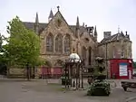 | |||
| 5,7,9 Water Row Former Ymca | 55°51′48″N 4°18′42″W | Category B | 33362 | | |||
| 301 Albert Drive, The Knowe, Including Lodge, Boundary Walls, Gates, Gatepiers And Gateway | 55°50′34″N 4°16′37″W | Category A | 33371 | | |||
| 352 Albert Drive, The Hollies, Including Boundary Walls And Gatepiers | 55°50′41″N 4°17′29″W | Category B | 33383 | | |||
| 362 Albert Drive, Park Lodge, Including Boundary Walls, Gatepiers And Railings | 55°50′40″N 4°17′39″W | Category B | 33385 | | |||
| 49, 49A Aytoun Road, Including Boundary Walls And Gatepiers | 55°50′35″N 4°17′17″W | Category C(S) | 33386 | | |||
| 3 Bruce Road, Including Boundary Walls And Gatepiers | 55°50′37″N 4°16′38″W | Category B | 33387 | | |||
| 7 And 7A Bruce Road, Leven View, Including Boundary Walls And Gatepiers | 55°50′38″N 4°16′42″W | Category B | 33388 | | |||
| 31 Dalziel Drive, Including Boundary Walls And Gatepiers | 55°50′30″N 4°17′43″W | Category B | 33394 | | |||
| 42 Dalziel Drive, Oak Knowe, Including Boundary Walls And Gatepiers | 55°50′31″N 4°17′31″W | Category B | 33398 | | |||
| 8 Nelson Mandela Place, Former Athenaeum | 55°51′45″N 4°15′15″W | Category A | 33234 | 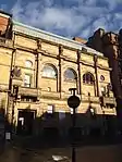 | |||
| 138, 140 West George Street, Provincial House | 55°51′45″N 4°15′25″W | Category B | 33240 | | |||
| 250-256 (Even Nos) West George Street (Known As 256) | 55°51′47″N 4°15′43″W | Category B | 33249 | | |||
| 106 West Nile Street, (Former Victoria Baths) | 55°51′47″N 4°15′15″W | Category B | 33254 | | |||
| 85-89 (Odd Nos) West Regent Street | 55°51′47″N 4°15′30″W | Category C(S) | 33260 | | |||
| 62-82 (Even Nos) West Regent Street | 55°51′48″N 4°15′25″W | Category C(S) | 33270 | | |||
| 146, 146A West Regent Street | 55°51′50″N 4°15′37″W | Category C(S) | 33275 | | |||
| 152-154A (Even Nos) West Regent Street And 130, 132 (Known As 130) West Campbell Street | 55°51′50″N 4°15′38″W | Category B | 33277 | | |||
| 133 Balornock Road, Stobhill Hospital, Medical Superintendent's House Including Staff Dining Room | 55°53′33″N 4°13′15″W | Category B | 33291 | | |||
| 50 Mansel Street And 61, Syriam Street, Springburn Academy, Former Albert Secondary School Including Janitor's Lodge | 55°53′09″N 4°13′29″W | Category B | 33295 | | |||
| 470, 480, 490, 500 And 510 Shieldhall Road, Hardgate Road, Luma Tower | 55°51′36″N 4°20′50″W | Category B | 33308 | 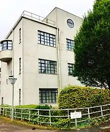 | |||
| 9 Skipness Drive, Linthouse/St Kenneth's Church Including Original Church Hall And Church Officer's House | 55°51′48″N 4°19′50″W | Category B | 33313 | 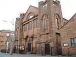 | |||
| 269-305 (Odd Nos) Sauchiehall Street, 123-127 (Odd Nos) Douglas Street, 192-200 (Even Nos) Pitt Street, Osborne Buildings | 55°51′55″N 4°15′51″W | Category B | 33176 | | |||
| 515-543 (Odd Nos) Sauchiehall Street And 241, 245 North Street | 55°51′57″N 4°16′21″W | Category B | 33182 | | |||
| 901, 903 Sauchiehall Street | 55°51′55″N 4°17′05″W | Category A | 33184 | | |||
| 931-979 (Odd Nos) Sauchiehall Street And 10-14 (Even Nos) Gray Street, 21 Derby Street (Wellesley Terrace) | 55°51′57″N 4°17′11″W | Category B | 33185 | | |||
| 76-82 (Even Nos) Sauchiehall Street And 109-117 (Odd Nos) Renfield Street | 55°51′53″N 4°15′21″W | Category B | 33187 | | |||
| 518 Sauchiehall Street and 333 Renfrew Street | 55°51′59″N 4°16′11″W | Category B | 33198 |  | |||
| 122-136 (Even Nos) Union Street And 41-55 (Odd Nos) Gordon Street And Union Place, Ca d’Oro Building | 55°51′37″N 4°15′24″W | Category A | 33209 |  | |||
| 27 Washington Street, Anderston Rice Mills | 55°51′31″N 4°16′05″W | Category B | 33210 | | |||
| 15-23 (Odd Nos) Waterloo Street, Waterloo Chambers | 55°51′36″N 4°15′36″W | Category B | 33212 | | |||
| 74 Waterloo Street, Fortune House, 70 Blythswood Street | 55°51′39″N 4°15′47″W | Category B | 33216 | | |||
| 18-25 (Inclusive Nos) Westminster Terrace, Sauchiehall Street | 55°51′55″N 4°17′01″W | Category B | 33220 | |
Key
The scheme for classifying buildings in Scotland is:
- Category A: "buildings of national or international importance, either architectural or historic; or fine, little-altered examples of some particular period, style or building type."[1]
- Category B: "buildings of regional or more than local importance; or major examples of some particular period, style or building type, which may have been altered."[1]
- Category C: "buildings of local importance; lesser examples of any period, style, or building type, as originally constructed or moderately altered; and simple traditional buildings which group well with other listed buildings."[1]
In March 2016 there were 47,288 listed buildings in Scotland. Of these, 8% were Category A, and 50% were Category B, with the remaining 42% being Category C.[2]
See also
Notes
- Sometimes known as OSGB36, the grid reference (where provided) is based on the British national grid reference system used by the Ordnance Survey.
• "Guide to National Grid". Ordnance Survey. Retrieved 12 December 2007.
• "Get-a-map". Ordnance Survey. Retrieved 17 December 2007. - Historic Environment Scotland assign a unique alphanumeric identifier to each designated site in Scotland, for listed buildings this always begins with "LB", for example "LB12345".
References
- All entries, addresses and coordinates are based on data from Historic Scotland. This data falls under the Open Government Licence
- "What is Listing?". Historic Environment Scotland. Retrieved 29 May 2018.
- Scotland's Historic Environment Audit 2016 (PDF). Historic Environment Scotland and the Built Environment Forum Scotland. pp. 15–16. Retrieved 29 May 2018.
This article is issued from Wikipedia. The text is licensed under Creative Commons - Attribution - Sharealike. Additional terms may apply for the media files.