List of listed buildings in Glasgow/11
List
| Name | Location | Date Listed | Grid Ref. [note 1] | Geo-coordinates | Notes | LB Number [note 2] | Image |
|---|---|---|---|---|---|---|---|
| Queen Margaret Drive, Queen Margaret Bridge | 55°52′46″N 4°17′11″W | Category B | 32577 |  | |||
| 8 And 8A Sydenham Road, (Newhall), With Terraces And Gatepiers | 55°52′43″N 4°18′12″W | Category B | 32587 | | |||
| 5 Victoria Circus, (Elstow) | 55°52′43″N 4°18′01″W | Category B | 32590 | | |||
| 43 Victoria Crescent Road And Walls | 55°52′35″N 4°17′54″W | Category B | 32597 | | |||
| 40 Kingsborough Gardens | 55°52′43″N 4°18′15″W | Category B | 32545 | | |||
| Kirklee Road Kirklee Bridge | 55°52′57″N 4°17′24″W | Category B | 32549 | | |||
| 8 Lowther Terrace, Great Western Road | 55°52′53″N 4°17′55″W | Category B | 32562 | | |||
| 9 Lowther Terrace, Great Western Road | 55°52′53″N 4°17′56″W | Category A | 32563 |  | |||
| 2 Mirrlees Drive | 55°52′58″N 4°17′47″W | Category B | 32568 | | |||
| 2 Prince Albert Road, (Holmhurst) | 55°52′39″N 4°18′05″W | Category B | 32572 | | |||
| 1 Horselethill Road, (Marleybank House) | 55°52′42″N 4°17′45″W | Category B | 32524 | %252C_Glasgow.jpg.webp) | |||
| 79 Hyndland Road, Hyndland Parish Church, Church Of Scotland | 55°52′45″N 4°18′19″W | Category A | 32532 | | |||
| 5 And 5B Cleveden Gardens And Gatepiers | 55°53′05″N 4°18′05″W | Category B | 32485 | | |||
| 2-8 (Even Nos) Crown Road North With 68 Dowanside Road And 2A-6A (Even Nos) Kinnoul Lane | 55°52′35″N 4°18′00″W | Category B | 32491 |  | |||
| 1 Queen Mary Avenue | 55°50′01″N 4°15′48″W | Category B | 32438 |  | |||
| 34 Queen's Drive, Southfield, Including Gatepiers | 55°49′54″N 4°15′38″W | Category C(S) | 32449 |  | |||
| 452-462 (Even Nos) Victoria Road/Prince Edward Street | 55°50′09″N 4°15′55″W | Category C(S) | 32465 | 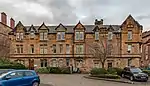 | |||
| 734-752 (Even Nos) Pollokshaws Road And 2-16 (Even Nos) Nithsdale Road | 55°50′12″N 4°16′13″W | Category B | 32402 | 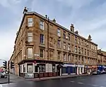 | |||
| 2 Sinclair Drive And Battlefield Road, Langside Public Library | 55°49′37″N 4°16′04″W | Category B | 32412 | 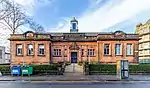 | |||
| 62 Albert Road And 327 Langside Road Including The Albert | 55°50′02″N 4°15′47″W | Category C(S) | 32419 | 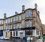 | |||
| 82 Albert Road | 55°50′01″N 4°15′43″W | Category B | 32420 |  | |||
| 15 Shakespeare Street, Ruchill Parish Church, (Church Of Scotland) | 55°53′12″N 4°17′00″W | Category B | 32355 |  | |||
| Marywood Square Lamp Standard In Front Of No 45 | 55°50′09″N 4°16′33″W | Category B | 32379 | | |||
| 295 Southbrae Drive, Formerly 523 Anniesland Road, Tower Dene | 55°53′07″N 4°20′57″W | Category C(S) | 32299 | | |||
| 1091 Great Western Road, 2 Whittingehame Gardens | 55°53′10″N 4°18′54″W | Category C(S) | 32323 | | |||
| 1095 Great Western Road, 4 Whittingehame Garden | 55°53′11″N 4°18′57″W | Category B | 32325 | | |||
| 1544 Great Western Road, Formerly County Bingo Hall And Ascot Cinema | 55°53′21″N 4°19′16″W | Category B | 32337 |  | |||
| 14-18 (Even Nos) Westend Park Street | 55°52′12″N 4°16′29″W | Category B | 32254 |  | |||
| 25 Lynedoch Street | 55°52′06″N 4°16′31″W | Category B | 32227 | 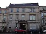 | |||
| Great Western Road Bridge Over River Kelvin | 55°52′29″N 4°16′47″W | Category A | 32197 | 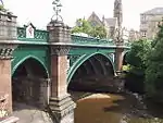 | |||
| 31 And 32 Lansdowne Crescent And 401 North Woodside Road | 55°52′30″N 4°16′38″W | Category C(S) | 32217 | | |||
| 340-342 (Even Nos) Cathedral Street, The Christian Centre | 55°51′48″N 4°14′55″W | Category C(S) | 46517 | | |||
| 58 Port Dundas Road, Buchanan House, Locomotion Statue | 55°52′01″N 4°15′15″W | Category C(S) | 47411 | | |||
| 28-40 (Even Nos) Union Street | 55°51′32″N 4°15′23″W | Category B | 49900 | | |||
| Partick Bridge Street, St Simon's Roman Catholic Church And Presbytery | 55°52′10″N 4°17′57″W | Category B | 49910 | 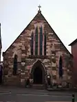 | |||
| 74 And 76 Netherlee Road, Braehead Villa, Including Gatepiers And Boundary Walls | 55°48′47″N 4°15′37″W | Category B | 50033 | | |||
| 35 Inchlee Street, 15, 16 Victoria Park Drive South Former Whiteinch Burgh Hall, Former Police Station And Former Fire Station Including Boundary Wall, Gatepiers And Railings | 55°52′28″N 4°20′03″W | Category B | 50283 | 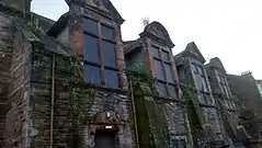 | |||
| 304-332 (Even Nos) Sauchiehall Street, Former Abc Regal Cinema, The O2 | 55°51′57″N 4°15′51″W | Category C(S) | 51547 | | |||
| 23-25 (Odd Nos) Belmont Street And 27 And 31 Lacrosse Terrace | 55°52′38″N 4°16′50″W | Category B | 44935 | | |||
| 61 Cleveden Drive And Cleveden Crescent Lane, Gatepiers, Boundary And Retaining Walls | 55°53′06″N 4°18′23″W | Category B | 44594 | | |||
| 5 Bridge Street And 15 Carlton Court, Cumbrae House | 55°51′15″N 4°15′28″W | Category B | 44041 | | |||
| 197 Nithsdale Road | 55°50′28″N 4°17′10″W | Category B | 43903 | | |||
| 165 Castlebank Street, Scotway House | 55°52′04″N 4°18′30″W | Category B | 43569 | | |||
| Linkwood Crescent, Campbell Colquhoun Burial Ground | 55°54′39″N 4°21′59″W | Category B | 43030 | | |||
| 436 Kinfauns Drive, Kinfauns Centre, Former Church Of Jesus Christ Of The Latter Day Saints | 55°54′48″N 4°21′22″W | Category B | 43032 | | |||
| 1114 Pollokshaws Road And 7 Moss-Side Road, Shawlands Cross Church And Hall | 55°49′50″N 4°16′55″W | Category B | 33956 |  | |||
| 12, 14 Regwood Street And Deanston Drive, South Shawlands Church And Halls | 55°49′32″N 4°17′06″W | Category B | 33961 | | |||
| 120 Sydney Street/Wellpark Street, Wellpark Occupational Centre | 55°51′30″N 4°13′48″W | Category B | 33907 | | |||
| Kilmarnock Road, Macquisten Bridge | 55°49′30″N 4°17′10″W | Category C(S) | 33925 | | |||
| 10, 12 Kilmarnock Road And 1155 Pollokshaws Road, Including The Granary, Crossmyloof Mansions | 55°49′48″N 4°16′55″W | Category B | 33927 |  | |||
| 5 Mansewood Road, Eastwood Parish Church, Church Of Scotland | 55°49′03″N 4°18′05″W | Category B | 33938 |  | |||
| 1 Saltmarket, Glasgow Cross The Mercat Cross | 55°51′23″N 4°14′37″W | Category B | 33856 |  | |||
| 46 Keppochill Road, 1, 11 Millarbank Street Sports Centre, Formerly Springburn Public Halls | 55°52′48″N 4°14′06″W | Category B | 33877 | | |||
| 99 Abercromby Street, St Mary's Rc Church | 55°51′14″N 4°13′37″W | Category A | 33810 |  | |||
| 120 Carstairs Street, Former Strathclyde Public School | 55°50′21″N 4°13′18″W | Category C(S) | 33822 | | |||
| 100 Duke Street, 1 And 3 Duke Wynd, Former Great Eastern Hotel | 55°51′34″N 4°14′03″W | Category B | 33828 | | |||
| 15 Clarendon Street | 55°52′23″N 4°16′07″W | Category B | 33756 | | |||
| 870 Garscube Road, Queens Cross Church And Hall (Formerly St Cuthberts And Queens Cross) | 55°52′49″N 4°16′19″W | Category A | 33764 |  | |||
| 74 And 76 Hopehill Road, St Columba Of Iona Rc Church And Presbytery, Retaining Wall And Gates | 55°52′35″N 4°16′00″W | Category A | 33765 |  | |||
| 75 Hotspur Street, Shakespeare Primary School, Gatepiers, Gates And Railings (Formerly Garrioch School) | 55°52′59″N 4°17′10″W | Category B | 33766 | | |||
| 71-79 (Odd Nos) Queen Margaret Drive | 55°52′49″N 4°17′06″W | Category C(S) | 33777 | | |||
| 65 Wilton Street | 55°52′41″N 4°16′27″W | Category C(S) | 33783 | | |||
| 325 Carmunnock Road, King's Park, Aikenhead House | 55°48′55″N 4°14′30″W | Category A | 33708 | | |||
| 318 Croftpark Avenue, Crofthill Road, Croftfoot Parish Church (Church Of Scotland), Hall, Gates And Railings | 55°48′53″N 4°13′55″W | Category B | 33714 | | |||
| 59 Machrie Road, Barlia Terrace, Castlemilk House Stables | 55°48′29″N 4°13′18″W | Category B | 33720 | | |||
| 38, 40 Snuffmill Road, Lindsay Tenement | 55°48′50″N 4°15′32″W | Category B | 33726 | | |||
| 101, 103 Inzievar Terrace, Carmyle, St Joachim's Roman Catholic Church And Presbytery | 55°50′05″N 4°09′14″W | Category C(S) | 33670 | | |||
| 513 Cathcart Road, 283 Calder Street, Candlish Polmadie Church Including Hall | 55°50′13″N 4°15′24″W | Category B | 33687 | | |||
| 197 Crookston Road, Ross Hall Park, Chimney Stalk At Walled Garden | 55°50′23″N 4°21′47″W | Category B | 33592 | | |||
| 1647 Paisley Road West, Nazareth House Including Chapel | 55°50′43″N 4°20′16″W | Category C(S) | 33602 | | |||
| 1435 Gallowgate And Duke Street | 55°51′05″N 4°11′52″W | Category B | 33632 | | |||
| 534 Paisley Road West, Former Ibrox Methodist Church | 55°51′03″N 4°18′19″W | Category B | 33582 | | |||
| 17 Sherbrooke Avenue 44 Hamilton Avenue, Sherbrooke House, Including Boundary Walls, Gates And Gatepiers | 55°50′31″N 4°17′54″W | Category B | 33469 | | |||
| 21 Sherbrooke Avenue, Balmory, Including Boundary Walls And Gatepiers | 55°50′28″N 4°17′55″W | Category B | 33470 | | |||
| 42 Sherbrooke Avenue And Springkell Avenue, Redhills, Including Gatepiers And Boundary Walls | 55°50′21″N 4°18′02″W | Category B | 33476 | | |||
| 525-529 (Odd Nos) Shields Road And Albert Drive, War Memorial Within Enclosure Of Pollokshields Church (C Of S) | 55°50′35″N 4°16′34″W | Category B | 33478 |  | |||
| 9, 11 Hamilton Avenue, Including Boundary Walls And Gatepiers | 55°50′25″N 4°17′34″W | Category B | 33413 | | |||
| 1 And 1A Leslie Road Belhaven Including Boundary Walls Gates And Gatepiers | 55°50′28″N 4°16′39″W | Category B | 33416 | | |||
| 43, 43A And 43B Maxwell Drive Including Boundary Walls And Gatepiers | 55°50′44″N 4°17′21″W | Category B | 33425 | | |||
| 227 Nithsdale Road, Including Boundary Walls And Gatepiers | 55°50′34″N 4°17′32″W | Category C(S) | 33441 | | |||
| 240 Nithsdale Road, Sherbrooke St Gilbert's Church And Hall | 55°50′39″N 4°17′56″W | Category B | 33453 | 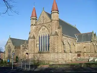 | |||
| Carmunnock, 22 Kirk Road | 55°47′24″N 4°14′08″W | Category B | 33323 | | |||
| Carmunnock, 26 And 28 Kirk Road | 55°47′24″N 4°14′09″W | Category C(S) | 33325 | | |||
| Carmunnock, 32 Kirk Road Brae House | 55°47′23″N 4°14′09″W | Category C(S) | 33326 | | |||
| Carmunnock, 145 Waterside Road | 55°47′18″N 4°14′04″W | Category C(S) | 33330 | | |||
| 20 Linn Park,Linn Park House | 55°48′18″N 4°15′42″W | Category B | 33334 | | |||
| 638-646 (Even Nos) Govan Road, 3 Napier Street, Napier House | 55°51′41″N 4°18′21″W | Category B | 33348 | | |||
| 62, 64 Langlands Road And Return Elevation To Roseneath Street, St Anthony's Rc Presbytery | 55°51′47″N 4°18′54″W | Category C(S) | 33359 | | |||
| 25 Albert Drive And 522 Pollokshaws Road, Tramway | 55°50′26″N 4°16′02″W | Category B | 33365 |  | |||
| 361 And 361A Albert Drive, The Laurels, Including Boundary Walls And Gatepiers | 55°50′38″N 4°17′32″W | Category C(S) | 33372 | | |||
| 194-198 (Even Nos) Albert Drive And 143-147 (Odd Nos) Kenmure Street | 55°50′32″N 4°16′21″W | Category B | 33377 | | |||
| 8 Bruce Road, Including Boundary Walls And Gatepiers | 55°50′39″N 4°16′40″W | Category C(S) | 33390 | | |||
| 92, 98 West George Street | 55°51′44″N 4°15′19″W | Category B | 33236 | | |||
| 158, 160 West George Street 150 Hope Street And West Regent Lane | 55°51′46″N 4°15′27″W | Category B | 33243 | | |||
| 196, 198 West George Street And 118 Wellington Street | 55°51′46″N 4°15′33″W | Category A | 33246 | | |||
| 230-248 (Even Nos) West George Street | 55°51′47″N 4°15′42″W | Category B | 33248 | | |||
| 9, 11, 13 West Graham Street | 55°52′05″N 4°15′41″W | Category B | 33251 | | |||
| 99-105 (Odd Nos) West Nile Street | 55°51′48″N 4°15′17″W | Category B | 33252 | | |||
| 88 West Regent Street And 168 Hope Street | 55°51′48″N 4°15′27″W | Category C(S) | 33271 | | |||
| 188 West Regent Street And 116 And 116A Blythswood Street | 55°51′50″N 4°15′43″W | Category B | 33280 | | |||
| 100 Belmont Road, Mosesfield House | 55°53′30″N 4°13′40″W | Category B | 33292 | | |||
| 52 Broomfield Road, Balgray Tower | 55°53′14″N 4°13′46″W | Category B | 33293 | | |||
| Elder Park, Fragments Of Linthouse Mansion | 55°51′48″N 4°19′37″W | Category B | 33303 | | |||
| 545-557 (Odd Nos) Sauchiehall Street | 55°51′58″N 4°16′23″W | Category B | 33183 | | |||
| 45 Scott Street And 71 Buccleuch Street, Garnethill Convent Nursery School | 55°52′03″N 4°15′51″W | Category B | 33201 | | |||
| 78-82 (Even Nos) Union Street | 55°51′35″N 4°15′23″W | Category B | 33207 | | |||
| 133-137 (Odd Nos) West George Street And 39-45 (Odd Nos) Renfield Street, Pearl Assurance Buildings | 55°51′44″N 4°15′24″W | Category B | 33224 | | |||
| 129 St Vincent Street | 55°51′41″N 4°15′32″W | Category B | 33141 | | |||
| 96 St Vincent Street | 55°51′42″N 4°15′22″W | Category B | 33154 | | |||
| 122-128 (Even Nos) St Vincent Street | 55°51′43″N 4°15′27″W | Category B | 33157 | | |||
| 242 St Vincent Street, Royal College Of Physicians | 55°51′45″N 4°15′49″W | Category B | 33165 |  | |||
| 300 St Vincent Street, St Columba's (Gaelic) Parish Church, Church Of Scotland | 55°51′47″N 4°16′00″W | Category B | 33168 | 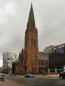 | |||
| 235 Sauchiehall Street, 147 Blythswood Street, Bank Of Scotland | 55°51′54″N 4°15′44″W | Category B | 33175 |  | |||
| 78-94 (Even Nos) Mitchell Street, 10, 14 And Gordon Public House, Mitchell Lane And 17-19 (Odd Nos) Gordon Lane, Gordon Chambers | 55°51′36″N 4°15′19″W | Category B | 33088 |  | |||
| 188 Pitt Street, And 209 Bath Street, Adelaide Place Baptist Church | 55°51′53″N 4°15′52″W | Category B | 33097 | | |||
| 71-79 (Odd Nos) Renfield Street With 48-50 (Even Nos) West Regent Street | 55°51′48″N 4°15′23″W | Category B | 33102 | | |||
| 23-27 (Odd Nos) Gordon Street And 96-100 (Even Nos) Mitchell Street | 55°51′37″N 4°15′19″W | Category B | 33027 | | |||
| 29-35 (Odd Nos) Gordon Street 101 Mitchell Street | 55°51′37″N 4°15′22″W | Category B | 33028 | | |||
| 129 Hill Street And 29 Garnet Street, Hill Street Synagogue | 55°52′02″N 4°16′04″W | Category A | 33040 | 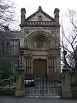 | |||
| 36 Jamaica Street And 10 Midland Street Gardner's | 55°51′27″N 4°15′27″W | Category A | 33065 | | |||
| Kelvinway Bridge Over Kelvin | 55°52′05″N 4°17′15″W | Category B | 33076 |  | |||
| 335 Bath Street And Elmbank Street, King's Theatre | 55°51′54″N 4°16′07″W | Category A | 32963 | 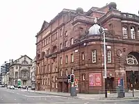 | |||
| 39-69 (Odd Nos) Bothwell Street, Mercantile Chambers | 55°51′40″N 4°15′40″W | Category A | 32980 | .jpg.webp) | |||
| 75 And 77 Bothwell Street | 55°51′40″N 4°15′42″W | Category B | 32981 | | |||
| No 4 Clairmont Gardens | 55°52′00″N 4°16′38″W | Category A | 33008 | | |||
| 286 Clyde Street And 1-5 (Odd Nos) Dixon Street | 55°51′23″N 4°15′22″W | Category B | 33011 | | |||
| 1125 And 1129 Argyle Street | 55°51′53″N 4°17′04″W | Category C(S) | 32944 | | |||
| 10 Partickhill Road, St Kentigern's Hostel (Front Building Only) | 55°52′27″N 4°18′12″W | Category B | 32893 | | |||
| 67 And 69 Partickhill Road | 55°52′30″N 4°18′37″W | Category B | 32896 | | |||
| 72 Peel Street, | 55°52′27″N 4°18′38″W | Category B | 32900 | | |||
| 42 Bute Gardens, Lilybank House | 55°52′27″N 4°17′25″W | Category A | 32853 | 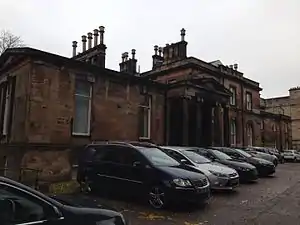 | |||
| 15, 21 Cecil Street, Hillhead Primary School | 55°52′34″N 4°17′14″W | Category B | 32855 | | |||
| 731 Great Western Road Bible Training Institute | 55°52′39″N 4°17′23″W | Category B | 32872 | | |||
| 89 Wilson Street With 52 Virginia Street | 55°51′31″N 4°14′59″W | Category B | 32806 | | |||
| 38 Parnie Street Tron Theatre, (Former Tron Kirk) And Curtain Wall And Railings To Chisholm Street | 55°51′24″N 4°14′45″W | Category A | 32812 | 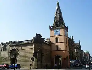 | |||
| 212 Saltmarket Justiciary Courts With Flank To Clyde Street | 55°51′13″N 4°14′49″W | Category A | 32844 |  | |||
| 47 Anderson Street, 23 Gullane Street, Partick Police Station | 55°52′11″N 4°18′19″W | Category B | 32845 | | |||
| 159-161 (Odd Nos) Ingram Street With 103 Hutcheson Street | 55°51′35″N 4°14′53″W | Category B | 32733 | | |||
| 103 Trongate | 55°51′25″N 4°14′49″W | Category B | 32773 | | |||
| 137 Trongate | 55°51′25″N 4°14′52″W | Category B | 32775 | | |||
| 33 Turnbull Street, Former Church Of St Andrew By The Green | 55°51′15″N 4°14′39″W | Category A | 32790 |  | |||
| 28-32 (Even Nos) Cathedral Square, John Knox Street, Cathedral House Hotel With Gatepiers And Gate | 55°51′43″N 4°14′06″W | Category B | 32653 |  | |||
| Cathedral Square, Statue Of James Lumsden | 55°51′47″N 4°14′09″W | Category B | 32658 |  | |||
| 72 Charlotte Street, Former Lady And St Francis Secondary School | 55°51′13″N 4°14′29″W | Category A | 32662 |  | |||
| 72 Clyde Street, Bridgegate, Merchants Steeple, Now Enclosed Within The Briggait | 55°51′17″N 4°14′57″W | Category A | 32665 | | |||
| 51-53 (Odd Nos) Cochrane Street | 55°51′37″N 4°14′55″W | Category B | 32673 | | |||
| 3-7 (Odd Nos) Dundas Street | 55°51′44″N 4°15′09″W | Category B | 32679 | | |||
| 1 George Square, 192-208 (Even Nos) Ingram Street, 4 Hanover Street, And 3 And 5 South Frederick Street, Former General Post Office | 55°51′37″N 4°15′00″W | Category A | 32685 | 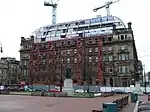 | |||
| 204 George Street, University Of Strathclyde, (Former Royal College Of Science And Technology) | 55°51′41″N 4°14′48″W | Category B | 32708 | | |||
| 61-65 (Odd Nos) Glassford Street | 55°51′32″N 4°14′57″W | Category B | 32712 | |
Key
The scheme for classifying buildings in Scotland is:
- Category A: "buildings of national or international importance, either architectural or historic; or fine, little-altered examples of some particular period, style or building type."[1]
- Category B: "buildings of regional or more than local importance; or major examples of some particular period, style or building type, which may have been altered."[1]
- Category C: "buildings of local importance; lesser examples of any period, style, or building type, as originally constructed or moderately altered; and simple traditional buildings which group well with other listed buildings."[1]
In March 2016 there were 47,288 listed buildings in Scotland. Of these, 8% were Category A, and 50% were Category B, with the remaining 42% being Category C.[2]
See also
Notes
- Sometimes known as OSGB36, the grid reference (where provided) is based on the British national grid reference system used by the Ordnance Survey.
• "Guide to National Grid". Ordnance Survey. Retrieved 12 December 2007.
• "Get-a-map". Ordnance Survey. Retrieved 17 December 2007. - Historic Environment Scotland assign a unique alphanumeric identifier to each designated site in Scotland, for listed buildings this always begins with "LB", for example "LB12345".
References
- All entries, addresses and coordinates are based on data from Historic Scotland. This data falls under the Open Government Licence
- "What is Listing?". Historic Environment Scotland. Retrieved 29 May 2018.
- Scotland's Historic Environment Audit 2016 (PDF). Historic Environment Scotland and the Built Environment Forum Scotland. pp. 15–16. Retrieved 29 May 2018.
This article is issued from Wikipedia. The text is licensed under Creative Commons - Attribution - Sharealike. Additional terms may apply for the media files.