List of listed buildings in Glasgow/13
List
| Name | Location | Date Listed | Grid Ref. [note 1] | Geo-coordinates | Notes | LB Number [note 2] | Image |
|---|---|---|---|---|---|---|---|
| 178 Royston Hill Townhead Blochairn Parish Church (Church Of Scotland) | 55°52′05″N 4°13′38″W | Category A | 32828 | 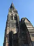 | |||
| 205-217 (Odd Nos) Ingram Street With 94-104 (Even Nos) Miller Street | 55°51′35″N 4°15′02″W | Category B | 32736 |  | |||
| 108-112 (Even Nos) Ingram Street And 10-12 (Even Nos) Montrose Street | 55°51′36″N 4°14′44″W | Category B | 32741 | 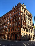 | |||
| 16 Mcphater Street, And Return Elevation To Dunblane Street (Ozalid's) | 55°52′02″N 4°15′19″W | Category A | 32754 | | |||
| 90 Maxwell Street | 55°51′22″N 4°15′15″W | Category B | 32756 | | |||
| 53-59 (Odd Nos) Miller Street | 55°51′32″N 4°15′05″W | Category B | 32757 | | |||
| 260 Clyde Street | 55°51′22″N 4°15′19″W | Category C(S) | 32670 | 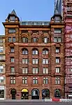 | |||
| 32 Fox Street | 55°51′23″N 4°15′17″W | Category B | 32680 | | |||
| 9 George Square, 5 Hanover Street, Lomond House | 55°51′38″N 4°15′03″W | Category B | 32686 | | |||
| George Square, Queen Victoria Statue | 55°51′41″N 4°15′04″W | Category A | 32702 |  | |||
| 151-59 (Odd Nos) George Street, University Of Strathclyde Alexander Turnbull Building | 55°51′39″N 4°14′40″W | Category C(S) | 32706 | | |||
| 266 George Street | 55°51′42″N 4°14′53″W | Category A | 32709 | 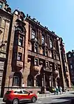 | |||
| 57-59 (Odd Nos) Glassford Street And 83-85 (Odd Nos) Wilson Street With Entrance To Glassford Court | 55°51′31″N 4°14′58″W | Category B | 32711 | | |||
| 16, 18, 28, 30 And 32 Argyle Street With Return Elevation To Virginia Street | 55°51′28″N 4°15′02″W | Category B | 32610 | 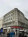 | |||
| 116-120 (Even Nos) Argyle Street | 55°51′30″N 4°15′16″W | Category B | 32617 | 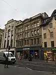 | |||
| 18 Blackfriars Street, The Babbity Bowster | 55°51′31″N 4°14′34″W | Category B | 32625 | | |||
| 3 Victoria Circus, (Cairndowan), And Gatepiers | 55°52′44″N 4°18′00″W | Category B | 32589 | | |||
| 69 Hyndland Road, St Brides Episcopal Church | 55°52′48″N 4°18′17″W | Category B | 32531 |  | |||
| 1, 3 Kingsborough Gardens | 55°52′45″N 4°18′18″W | Category B | 32540 | | |||
| 730 Great Western Road; Botanic Gardens, Gates At Queen Margaret Drive, Gates At Kirklee Quadrant And Boundary Railings | 55°52′41″N 4°17′23″W | Category B | 32511 | | |||
| 183 Prospecthill Road, Mount Florida Clinic | 55°49′41″N 4°15′36″W | Category B | 32437 | 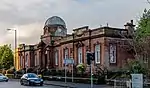 | |||
| 2-8 (Even Nos) Queen Mary Avenue | 55°50′00″N 4°15′49″W | Category C(S) | 32440 | 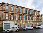 | |||
| Queen's Park Glass Houses | 55°49′44″N 4°16′15″W | Category B | 32409 | 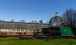 | |||
| 34 Cathkin Road Including Gatepiers | 55°49′30″N 4°16′21″W | Category B | 32367 | 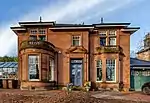 | |||
| Marywood Square Lamp Standard In Front Of No 55 | 55°50′10″N 4°16′35″W | Category B | 32380 | 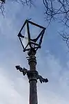 | |||
| Nithsdale Drive And Nithsdale Street, K6 Telephone Kiosk | 55°50′15″N 4°16′20″W | Category B | 32392 | | |||
| 16-22 (Even Nos) Beaconsfield Road, St John's Renfield Church, Church Of Scotland, Halls And Church Officer's House | 55°53′10″N 4°18′22″W | Category B | 32301 | 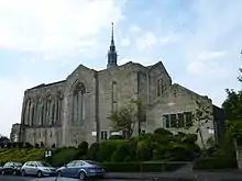 | |||
| 1 Cleveden Crescent And Cleveden Crescent Lane, Gatepiers, Boundary And Retaining Walls | 55°53′03″N 4°18′12″W | Category B | 32304 | | |||
| 5 Cleveden Road, Boundary Walls And Gatepiers | 55°53′00″N 4°18′11″W | Category B | 32314 | | |||
| 1093 Great Western Road, 3 Whittingehame Gardens | 55°53′10″N 4°18′56″W | Category C(S) | 32324 | | |||
| 76 Southbrae Drive, Jordanhill College Of Education | 55°53′05″N 4°20′24″W | Category B | 32339 | | |||
| 1996 Great Western Road, Knightswood Cross, Knightswood Road, St Margaret's Church (Church Of Scotland) | 55°53′43″N 4°20′30″W | Category B | 32274 | | |||
| 739 South Street, North British Engine Works | 55°52′23″N 4°20′40″W | Category A | 32280 | | |||
| 21 Westland Drive | 55°52′40″N 4°20′23″W | Category B | 32285 | | |||
| 9 University Avenue Gilmorehill Hall | 55°52′20″N 4°17′04″W | Category B | 32251 | 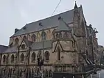 | |||
| 32, 34, 36, 44, 46, 48, 50 Woodlands Road | 55°52′06″N 4°16′20″W | Category B | 32264 | | |||
| 8-12 Even Nos Glasgow Street And 18 Bank Street | 55°52′29″N 4°17′00″W | Category B | 32194 | | |||
| Kelvingrove Park, Stewart Memorial Fountain | 55°52′05″N 4°17′02″W | Category A | 32213 | 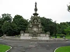 | |||
| 29 And 30 Lansdowne Crescent And 393 North Woodside Road | 55°52′31″N 4°16′37″W | Category C(S) | 32216 | | |||
| Dumbarton Road, Whiteinch, St Paul's Roman Catholic Church Including Boundary Walls, Gatepiers, Gates And Railings | 55°52′26″N 4°20′18″W | Category B | 48412 | | |||
| 300 Cathedral Street, Charles Oakley Campus, Central College Of Commerce | 55°51′48″N 4°14′51″W | Category B | 48413 | 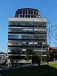 | |||
| Willowbank Street, Willowbank Primary School Including Boundary Wall, Gatepiers, Railings And Gates | 55°52′17″N 4°16′30″W | Category C(S) | 48628 | | |||
| 52-62 (Even Nos) Renfield Street, Odeon Cinema And Shops | 55°51′46″N 4°15′21″W | Category B | 49233 | 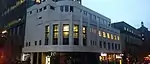 | |||
| 101 Carstairs Street, Laird Business Park (Former Glasgow Cotton Spinning Co Mill) | 55°50′22″N 4°13′13″W | Category B | 49924 | | |||
| 143 Oxford Street | 55°51′13″N 4°15′29″W | Category C(S) | 49933 | | |||
| 722 Cumbernauld Road, Nb Leisure Bingo, Former Riddrie Picture House Including Sweet Shop And Power House | 55°51′51″N 4°11′47″W | Category B | 51104 | | |||
| Langside Synagogue | Category C | 52561 | |
Key
The scheme for classifying buildings in Scotland is:
- Category A: "buildings of national or international importance, either architectural or historic; or fine, little-altered examples of some particular period, style or building type."[1]
- Category B: "buildings of regional or more than local importance; or major examples of some particular period, style or building type, which may have been altered."[1]
- Category C: "buildings of local importance; lesser examples of any period, style, or building type, as originally constructed or moderately altered; and simple traditional buildings which group well with other listed buildings."[1]
In March 2016 there were 47,288 listed buildings in Scotland. Of these, 8% were Category A, and 50% were Category B, with the remaining 42% being Category C.[2]
See also
Notes
- Sometimes known as OSGB36, the grid reference (where provided) is based on the British national grid reference system used by the Ordnance Survey.
• "Guide to National Grid". Ordnance Survey. Retrieved 12 December 2007.
• "Get-a-map". Ordnance Survey. Retrieved 17 December 2007. - Historic Environment Scotland assign a unique alphanumeric identifier to each designated site in Scotland, for listed buildings this always begins with "LB", for example "LB12345".
References
- All entries, addresses and coordinates are based on data from Historic Scotland. This data falls under the Open Government Licence
- "What is Listing?". Historic Environment Scotland. Retrieved 29 May 2018.
- Scotland's Historic Environment Audit 2016 (PDF). Historic Environment Scotland and the Built Environment Forum Scotland. pp. 15–16. Retrieved 29 May 2018.
This article is issued from Wikipedia. The text is licensed under Creative Commons - Attribution - Sharealike. Additional terms may apply for the media files.