List of listed buildings in Glasgow/4
List
| Name | Location | Date Listed | Grid Ref. [note 1] | Geo-coordinates | Notes | LB Number [note 2] | Image |
|---|---|---|---|---|---|---|---|
| 40 Newlands Road And Lubnaig Road, The Oaks Including Garden Walls And Gatepiers | 55°49′12″N 4°16′52″W | Category B | 33948 |  | |||
| 42 Newlands Road And 7 Lubnaig Road, Brackley, Including Walls And Gatepiers | 55°49′12″N 4°16′49″W | Category B | 33949 | | |||
| 988-1006 (Even Nos) Pollokshaws Road, Camphill Gate | 55°49′56″N 4°16′42″W | Category B | 33954 | | |||
| 95 Morrison Street, 34-44 (Even Nos) Dalintober Street, 19-37 (Odd Nos) Carnoustie Street, "Co-Operative House" | 55°51′13″N 4°16′10″W | Category B | 33971 | | |||
| 19,21 Broompark Drive, Including Gatepiers | 55°51′41″N 4°13′27″W | Category B | 33888 | | |||
| 164, 166 Craigpark, Snooker Club Including Gatepiers | 55°51′49″N 4°13′17″W | Category B | 33895 | | |||
| 35, 37 Westercraigs, 36,38 Broompark Drive | 55°51′39″N 4°13′26″W | Category B | 33910 | | |||
| 17-23 (Odd Nos) Whitevale Street, St Anne's Church And Presbytery | 55°51′27″N 4°12′58″W | Category A | 33912 | | |||
| 230 Auldhouse Road Including Gatepiers | 55°49′08″N 4°17′58″W | Category C(S) | 33914 | | |||
| 443 Clarkston Road, Gartly Street, Muirend Trustee Savings Bank, Originally Savings Bank Of Glasgow | 55°48′37″N 4°16′14″W | Category B | 33917 | | |||
| 84, 86 Clarkston Road, Couper Institute And Library | 55°48′57″N 4°15′53″W | Category B | 33918 | | |||
| 90, 92 Clarkston Road, Cathcart South Church Of Scotland, Including Hall | 55°48′55″N 4°15′56″W | Category B | 33919 | | |||
| 45 Netherlee Road, "Cartbank" | 55°48′45″N 4°15′29″W | Category B | 33943 | | |||
| 61, 63 Netherlee Road, "Holmwood" | 55°48′35″N 4°15′34″W | Category A | 33944 | 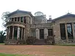 | |||
| Graham Square/Bellgrove Street/14-28 Melbourne Street/Moore Street Meat And Cattle Markets,And Associated Buildings | 55°51′28″N 4°13′36″W | Category B | 33842 | | |||
| 88 Green Street, St James Public School Including Janitor's House And Railings | 55°51′10″N 4°13′59″W | Category B | 33843 | | |||
| 50-56 (Even Nos) Old Dalmarnock Road, Church Of The Sacred Heart Including Gatepiers And Presbytery | 55°50′46″N 4°13′24″W | Category A | 33855 | | |||
| Gartloch Road, Gartloch Hospital, Asylum Section, Hospital Section And Original Nurses' Home | 55°52′46″N 4°06′21″W | Category A | 33868 |  | |||
| Alexandra Parade, Alexandra Park, Cast-Iron Fountain | 55°51′52″N 4°12′30″W | Category A | 33880 | 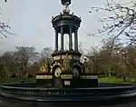 | |||
| 1208-1220, (Even Nos) Cathcart Road, Battlefield East Church And Hall, Including Gatepiers | 55°49′25″N 4°15′32″W | Category B | 33803 |  | |||
| 70-74 (Even Nos) Mount Annan Drive Including Boundary Walls | 55°49′26″N 4°15′23″W | Category B | 33808 | | |||
| Bridgeton Cross, Shelter | 55°50′56″N 4°13′35″W | Category A | 33818 | 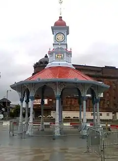 | |||
| 103-111 (Odd Nos) French Street, 34-66 (Even Nos) Dora Street, (Former Barrowfield Weaving Factory) | 55°50′31″N 4°13′20″W | Category B | 33830 | | |||
| Glasgow Green, Nelson Monument, Including Railings | 55°51′05″N 4°14′27″W | Category A | 33837 | 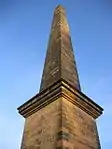 | |||
| 263-273 (Odd Nos) Garrioch Road And Railings | 55°52′56″N 4°17′19″W | Category C(S) | 33762 | | |||
| Kelvinside Terrace, West Steps And Retaining Walls | 55°52′45″N 4°17′03″W | Category B | 33772 | 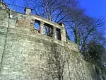 | |||
| 2-14 (Even Nos) Possil Road And Farnell Street, Tower Buildings | 55°52′28″N 4°15′40″W | Category B | 33776 | | |||
| 361-367 (Odd Nos) St George's Road, Lampost And Railings | 55°52′20″N 4°16′01″W | Category B | 33781 | | |||
| 67 Coplaw Street, 134 Butterbiggins Road, Former Glasgow Samaritan Hospital For Women Including Boundary Walls Gatepiers And Railings | 55°50′25″N 4°15′44″W | Category B | 33689 | 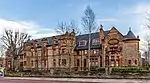 | |||
| 44 Kingarth Street, Calder Street, Hutcheson's Grammar School Annexe, Janitors Lodge And Gymnasium Block | 55°50′19″N 4°15′56″W | Category B | 33694 | 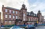 | |||
| 23, 25 And 27 Snuff Mill Road, Snuff Mill, Cathcart | 55°48′49″N 4°15′32″W | Category C(S) | 33725 | | |||
| 393 Ashgill Road, St Augustine`S Rc Church And Presbytery | 55°53′46″N 4°14′21″W | Category B | 33736 | | |||
| 11 - 29 (Odd Nos) Canal Bank, With Bank Openings | 55°53′50″N 4°15′55″W | Category B | 33739 | | |||
| 862 Shettleston Road And Wellshot Road, Carntyne Old Church And Hall, Gates And Railings | 55°51′06″N 4°10′30″W | Category C(S) | 33646 | | |||
| 64-80 (Even Nos) Tollcross Road And Helenvale Street, Parkhead Library Including Public Baths And Washhouse | 55°51′01″N 4°11′44″W | Category B | 33653 | 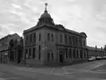 | |||
| 1-15 (Odd Nos) Westmuir Street And 1361 Duke Street | 55°51′04″N 4°11′51″W | Category B | 33656 | | |||
| 135 Westmuir Street, Parkhead Careers Office Including Gatepiers And Railings | 55°51′07″N 4°11′34″W | Category B | 33657 | | |||
| 138 Carmyle Avenue, Carmyle House, Gates And Gatepiers | 55°49′52″N 4°09′37″W | Category B | 33662 | .jpg.webp) | |||
| 50 And 52 Church Street, Baillieston, Old St Andrew's Church Including Boundary Walls, Gatepiers, Gates And Railings | 55°50′59″N 4°06′30″W | Category B | 33663 | | |||
| Manse Road, Bargeddie, Netherhouse Road, Bargeddie Parish Church Including Hall, Manse, Lodge And Perimeter Walls | 55°51′29″N 4°05′33″W | Category B | 33672 | | |||
| 165, 171, 173 Butterbiggins Road, 48, 54, 60 Inglefield Street | 55°50′25″N 4°15′29″W | Category C(S) | 33681 | 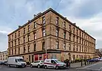 | |||
| 176-194 (Even Nos) Butterbiggins Road, 65-73 (Odd Nos) Inglefield Street, 143, 145 Coplaw Street | 55°50′23″N 4°15′27″W | Category B | 33682 | 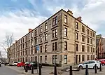 | |||
| 35 Coplaw Street, Leisure Centre | 55°50′25″N 4°15′52″W | Category C(S) | 33688 | | |||
| 2141 Paisley Road West, Cardonald Parish Church Including Hall | 55°50′44″N 4°21′21″W | Category B | 33603 | 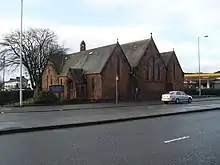 | |||
| Ralston Avenue 81, 85 (Struan) Including Boundary Walls And Gatepiers | 55°50′32″N 4°22′03″W | Category B | 33604 | | |||
| 5 And 7 Applecross Street, Rockvilla House, Former Canal Lock Keeper`S House | 55°52′38″N 4°15′36″W | Category C(S) | 33609 | | |||
| 40-50 (Even Nos) Speirs Wharf | 55°52′26″N 4°15′28″W | Category B | 33620 | | |||
| 184-238A (Even Nos) Saracen Street | 55°53′00″N 4°15′14″W | Category B | 33622 | | |||
| 98-100 (Even Nos) Pollokshaws Road And 3 Cavendish Street, Former Chalmer's Free Church | 55°50′48″N 4°15′28″W | Category B | 33530 | 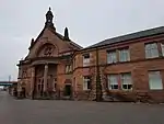 | |||
| 191,193,195,197,199 Scotland Street, Former Howden's Works | 55°50′57″N 4°16′21″W | Category B | 33533 | | |||
| 84 And 86 Craigie Street, 52 Allison Street (52 Allison Court) And 2-6 (Even Nos) Allison Place | 55°50′11″N 4°16′01″W | Category B | 33542 | | |||
| 1226-1236 (Even Nos) Maryhill Road/Ruchill Street, Wyndford Club | 55°53′15″N 4°17′07″W | Category C(S) | 33543 | | |||
| 167 Ashkirk Drive, Mosspark Parish Church (Church Of Scotland) | 55°50′29″N 4°19′32″W | Category B | 33584 | 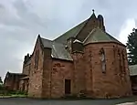 | |||
| 1554 Barrhead Road, 17-20 (Inclusive) Hurlethill Court, East Hurlet House | 55°49′10″N 4°22′13″W | Category B | 33585 | | |||
| 27, 29 Sherbrooke Avenue And 102 Springkell Avenue, Matheran, Including Driveway Gate And Boundary Walls | 55°50′24″N 4°17′57″W | Category B | 33471 | | |||
| 31 Sherbrooke Avenue And 105 Springkell Avenue, Oaklands, Including Boundary Walls And Gatepiers | 55°50′21″N 4°17′57″W | Category B | 33472 | | |||
| 39 Sherbrooke Avenue, Inchgarvie And Woodmailing, Including Boundary Walls And Gatepiers | 55°50′20″N 4°17′54″W | Category B | 33474 | | |||
| 525-529 (Odd Nos) Shields Road And 274 Albert Drive, Pollokshields Church (C Of S) And Hall, Gates And Railings | 55°50′36″N 4°16′32″W | Category B | 33477 | 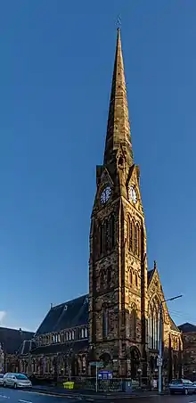 | |||
| 689-707 (Odd Nos) Shields Road, 16-20 (Even Nos) Glencairn Drive, 1-9 (Odd Nos) Newark Drive | 55°50′21″N 4°16′37″W | Category B | 33480 | | |||
| 96 Springkell Avenue And 398 Albert Drive, Including Boundary Walls And Gatepiers | 55°50′22″N 4°17′48″W | Category C(S) | 33484 | | |||
| 44-84 (Even Nos) Terregles Avenue And 733-745 (Odd Nos) Shields Road | 55°50′17″N 4°16′35″W | Category C(S) | 33488 | | |||
| 40-61 (Inclusive) Carlton Place And 16 Nicholson Street | 55°51′13″N 4°15′19″W | Category A | 33499 | 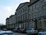 | |||
| 65-84 (Inclusive) Carlton Place And 4 South Portland Street | 55°51′16″N 4°15′27″W | Category B | 33500 | | |||
| 38 Clyde Place And 18 Centre Street, Former Kingston House | 55°51′18″N 4°15′42″W | Category B | 33501 | | |||
| 121 Eglinton Street And Bedford Street, New Bedford Picture House | 55°51′02″N 4°15′33″W | Category B | 33508 | 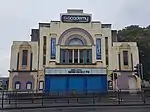 | |||
| 8-38 (Even Nos) Falfield Street, 14, 16, 20 Stromness Street And 39 Mauchline Street, Former Falfield Cotton Works | 55°50′51″N 4°15′46″W | Category B | 33511 | | |||
| 162-170 (Even Nos) Gorbals Street | 55°51′00″N 4°15′16″W | Category A | 33513 | 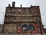 | |||
| 40 And 44 Kilbirnie Street And Return Elevations To Ritchie Street And Francis Street | 55°50′49″N 4°15′46″W | Category B | 33515 | | |||
| 53 Morrison Street, 33 Dalintober Street And Return Elevation To Laidlaw Street | 55°51′12″N 4°16′07″W | Category B | 33519 | | |||
| 115-119 (Even Nos) Paisley Road, 120-130 (Even Nos) Morrison Street And 2, 4 Laidlaw Street And 1 Dalintober Street "Paisley Road Gusset" Scws | 55°51′15″N 4°16′05″W | Category B | 33523 | | |||
| 656-674 (Even Nos) Eglinton Street And 2-28 (Even Nos) Maxwell Road | 55°50′36″N 4°15′47″W | Category B | 33404 | | |||
| 19-63 (Odd Nos) Glencairn Drive And 719, 721 Shields Road | 55°50′18″N 4°16′36″W | Category B | 33407 | | |||
| 97 Haggs Road Lodge At Pollok House | 55°50′02″N 4°17′58″W | Category B | 33412 | | |||
| 110, 112 Hamilton Avenue And Springkell Avenue, Dunholme, Including Boundary Walls And Gatepiers | 55°50′21″N 4°18′13″W | Category B | 33414 | | |||
| 165-189 (Odd Nos) Kenmure Street | 55°50′30″N 4°16′21″W | Category B | 33415 | 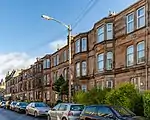 | |||
| 11 Melville Street, Pollokshields Primary School Annexe, Former Pollokshields Public School Including Janitor's Lodge, Gatepiers And Railings | 55°50′23″N 4°16′18″W | Category B | 33428 | 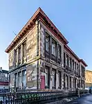 | |||
| 10 Newark Drive, Newark Drive Nursery School And 159 Nithsdale Road, Kilspindie, Including Boundary Walls And Gatepiers | 55°50′24″N 4°16′41″W | Category C(S) | 33434 | | |||
| 161 Nithsdale Road, Including Boundary Walls, Gatepiers And Railings | 55°50′24″N 4°16′42″W | Category B | 33438 | | |||
| 116-170 (Even Nos) Nithsdale Road, 2, 3, 4, Nithsdale Place, Kenmure Street And Leven Street | 55°50′21″N 4°16′31″W | Category B | 33445 | 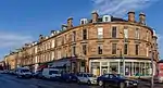 | |||
| 178 Nithsdale Road, Helenslea, Including Boundary Walls And Gatepiers | 55°50′30″N 4°16′51″W | Category B | 33447 | 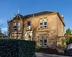 | |||
| 196 Nithsdale Road, Glengowan, Including Boundary Walls And Gatepiers | 55°50′31″N 4°17′06″W | Category C(S) | 33448 | | |||
| 206 Nithsdale Road, Braehead, Including Boundary Walls And Gatepiers | 55°50′33″N 4°17′17″W | Category C(S) | 33452 | | |||
| 2060 Pollokshaws Road, Pollok House, Bridge Over White Cart Water | 55°49′37″N 4°19′05″W | Category A | 33456 | 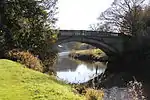 | |||
| 2060 Pollokshaws Road, Pollok House Sawmill, Power Station And Caul | 55°49′33″N 4°18′59″W | Category B | 33458 | | |||
| Carmunnock 652 Carmunnock Road, Mid Netherton Farmhouse And Steading | 55°47′49″N 4°15′02″W | Category C(S) | 33318 | | |||
| Carmunnock, 1 Greenside | 55°47′28″N 4°14′03″W | Category C(S) | 33319 | | |||
| Carmunnock, 2, 4 Kirk Road | 55°47′28″N 4°14′09″W | Category C(S) | 33320 | | |||
| Carmunnock, Kirk Road, Carmunnock Parish Church And Churchyard Including Gatepiers And Watch House | 55°47′25″N 4°14′09″W | Category B | 33322 | .jpg.webp) | |||
| Carmunnock, 34 Kirk Road | 55°47′23″N 4°14′09″W | Category B | 33327 | | |||
| 65-69 (Odd Nos) Golspie Street, Former Hill's Trust School | 55°51′43″N 4°19′01″W | Category B | 33339 | | |||
| 705, 707 Govan Road, Return Elevations To Broomloan Road, Former Savings Bank, Govan Branch | 55°51′42″N 4°18′32″W | Category B | 33342 | | |||
| 801, 805 Govan Road, 2, 4 Burleigh Street, Cardell Halls And Public House | 55°51′48″N 4°18′47″W | Category B | 33344 | | |||
| 18,20 Orkney Street Govan Police Building, Former Govan Municipal Buildings | 55°51′40″N 4°18′31″W | Category B | 33361 | | |||
| 143 Woodville Street. Now Maritime House, Former Glasgow Engineering Works | 55°51′18″N 4°18′24″W | Category B | 33363 | | |||
| 241 Albert Drive And Herriet Street, (Including Academy Building To Herriet Street), Pollokshields Primary School Including Gatepiers, Playground Walls And Railings | 55°50′32″N 4°16′29″W | Category B | 33370 | | |||
| 312 Albert Drive, Including Gatepiers And Boundary Walls | 55°50′37″N 4°16′46″W | Category B | 33378 | 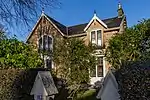 | |||
| 18 Bruce Road, Including Boundary Walls And Gatepiers | 55°50′41″N 4°16′54″W | Category B | 33392 | | |||
| 28, 30 Dalziel Drive And 69 St Andrew's Drive, The Moss, Including Boundary Walls And Gatepiers | 55°50′28″N 4°17′21″W | Category B | 33395 | | |||
| 40 Dalziel Drive, Dykeneuk House, Including Boundary Walls And Gatepiers | 55°50′30″N 4°17′30″W | Category B | 33397 | | |||
| 46-50 (Even Nos) Darnley Street And 49-53 (Odd Nos) Forth Street, Miller And Lang Building, Pollokshields, Also Known As 50 Darnley Street | 55°50′35″N 4°16′10″W | Category A | 33402 | | |||
| 166, 168 West George Street And 175 Hope Street | 55°51′46″N 4°15′30″W | Category B | 33244 | | |||
| 188-194 (Even Nos) West George Street | 55°51′46″N 4°15′32″W | Category B | 33245 | | |||
| 202-226 (Even Nos) West George Street 115, 117 Wellington Street And 114-118 (Even Nos) West Campbell Street | 55°51′47″N 4°15′36″W | Category B | 33247 | | |||
| 141, 143 West Regent Street, 120-124 (Even Nos) West Campbell Street | 55°51′48″N 4°15′39″W | Category B | 33268 | | |||
| 4, 4A West Regent Street, And 64-70 (Even Nos) Renfield Street, Victoria Buildings | 55°51′47″N 4°15′20″W | Category B | 33269 | | |||
| 158-168 (Even Nos) West Regent Street And 237 West Campbell Street (Former John Ross Memorial Church For The Deaf And Institute For Adult Deaf And Dumb) | 55°51′50″N 4°15′40″W | Category B | 33278 | | |||
| Renfield Street, William Annan Fountain | 55°51′57″N 4°15′18″W | Category C(S) | 33287 | | |||
| 1378 Springburn Road, Colston Wellpark Church, Church Of Scotland | 55°53′42″N 4°13′51″W | Category B | 33299 | | |||
| Carmunnock, 8, 10 Busby Road | 55°47′27″N 4°14′10″W | Category B | 33314 | | |||
| 351-371 (Odd Nos) Sauchiehall Street, 97 Holland Street | 55°51′56″N 4°16′01″W | Category B | 33178 | 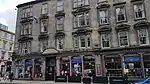 | |||
| 401-427 (Odd Nos) Sauchiehall Street And 67-73 (Odd Nos) Elmbank Street | 55°51′57″N 4°16′06″W | Category B | 33180 | 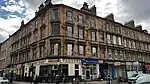 | |||
| 130-158 (Even Nos) Sauchiehall Street, The Savoy Centre | 55°51′54″N 4°15′28″W | Category B | 33190 | 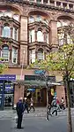 | |||
| 254-290 (Even Nos) Sauchiehall Street, 5, 7 Rose Street, 2, 6 Dalhousie Street And 145, 147, 149 Renfrew Street, Mclellan Galleries | 55°51′58″N 4°15′44″W | Category B | 33192 | 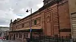 | |||
| 73-77 (Odd Nos) Waterloo Street | 55°51′37″N 4°15′47″W | Category C(S) | 33213 | | |||
| 40-60 (Even Nos) Wellington Street 1, 3 Cadogan Street And 102-108 (Even Nos) Holm Street, Baltic Chambers | 55°51′34″N 4°15′37″W | Category B | 33218 | | |||
| 117, 121 West George Street And 38-42 (Even Nos) Renfield Street, (Former Sun Life Building) | 55°51′43″N 4°15′22″W | Category A | 33223 | | |||
| 201-203 (Odd Nos) West George Street 101-107 (Odd Nos) Wellington Street And 98 West George Lane | 55°51′45″N 4°15′36″W | Category B | 33227 | | |||
| 223-225A (Odd Nos) West George Street | 55°51′46″N 4°15′39″W | Category B | 33230 | | |||
| 149 St Vincent Street | 55°51′42″N 4°15′37″W | Category B | 33144 | | |||
| 80 St Vincent Street | 55°51′42″N 4°15′20″W | Category B | 33152 | | |||
| 140, 142 St Vincent Street And 153, 155 Hope Street, Royal Bank Building | 55°51′43″N 4°15′31″W | Category A | 33159 | 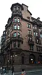 | |||
| 142A, 144 St Vincent Street | 55°51′43″N 4°15′31″W | Category A | 33160 | 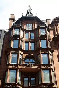 | |||
| 202-228 (Even Nos) St Vincent Street | 55°51′44″N 4°15′42″W | Category B | 33163 | _ST_VINCENT_STREET.jpg.webp) | |||
| 219-233, (Odd Nos) Sauchiehall Street And 134-140 (Even Nos) Blythswood Street | 55°51′54″N 4°15′42″W | Category B | 33174 | | |||
| 48-88 (Even Nos) Kent Road, 7-9 (Odd Nos) Granville Street, 100 Elderslie Street | 55°51′53″N 4°16′26″W | Category B | 33080 | | |||
| 101, 103, New City Road | 55°52′09″N 4°15′47″W | Category B | 33090 | | |||
| 55 North Street And 101, 121, William Street, St Patrick's Rc Church | 55°51′43″N 4°16′17″W | Category B | 33093 | 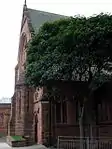 | |||
| 20, 26, 28 Renfield Lane And St Vincent Lane, Former Daily Record Building | 55°51′40″N 4°15′28″W | Category A | 33099 | | |||
| 167 Renfrew Street And 11, 15 Dalhousie Street, Glasgow School Of Art | 55°51′58″N 4°15′49″W | Category A | 33105 | 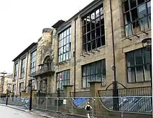 | |||
| 347-353 (Odd Nos) Renfrew Street, Albany Mansions | 55°52′00″N 4°16′12″W | Category B | 33108 |  | |||
| 16 Robertson Street, Clyde Navigation Trust | 55°51′25″N 4°15′39″W | Category A | 33113 | | |||
| 60-64 (Even Nos) Robertson Street | 55°51′29″N 4°15′38″W | Category B | 33114 | | |||
| 52, 56 Rose Street And 23 Buccleuch Street | 55°52′02″N 4°15′39″W | Category B | 33119 | | |||
| 1-20 (Inclusive Nos) Royal Terrace, 11B-19 (Odd Nos) North Claremont Street And 66 Kelvingrove Street | 55°51′59″N 4°16′52″W | Category B | 33121 | | |||
| 34, 36 St Enoch Square | 55°51′27″N 4°15′22″W | Category B | 33124 | | |||
| 120, Elmbank Street With 71-83 (Odd Nos) Holland Street And Lodges, 59, 61 Holland Street, Gates And Retaining Walls | 55°51′52″N 4°16′04″W | Category A | 33022 | | |||
| 97-113B (Odd Nos) Hill Street, Breadalbane Terrace | 55°52′01″N 4°15′56″W | Category A | 33038 | | |||
| 114 Hill Street, Bilsland House | 55°52′03″N 4°16′00″W | Category C(S) | 33045 | | |||
| 157-167 (Odd Nos) Hope Street And 169-175 (Odd Nos) West George Street | 55°51′44″N 4°15′31″W | Category A | 33053 | 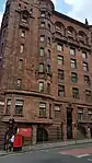 | |||
| 217-225 (Odd Nos) Hope Street | 55°51′49″N 4°15′28″W | Category C(S) | 33054 | | |||
| Jamaica Street, Glasgow Bridge | 55°51′20″N 4°15′28″W | Category B | 33062 | 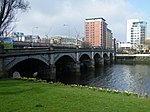 | |||
| 18-22 (Even Nos) Jamaica Street | 55°51′29″N 4°15′27″W | Category B | 33063 | | |||
| 66-72 (Even Nos) James Watt Street (Known As 72 James Watt Street) | 55°51′30″N 4°15′50″W | Category A | 33070 | | |||
| 182-200 (Even Nos) Bath Street Also Known As Athol Place | 55°51′53″N 4°15′45″W | Category B | 32967 | | |||
| 264, 266 Bath Street And 150-160 (Even Nos) Elmbank Street And Sauchiehall Lane, Including The Griffin Public House | 55°51′56″N 4°16′05″W | Category B | 32971 | 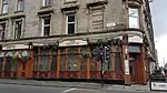 | |||
| 14-20A (Inclusive Nos) Blythswood Square And 108 Douglas Street | 55°51′47″N 4°15′50″W | Category B | 32977 | | |||
| 30 Bothwell Street And 100 Wellington Street | 55°51′41″N 4°15′35″W | Category B | 32984 | | |||
| 36-44 (Even Nos) Bothwell Street 87, 89 Wellington Street | 55°51′41″N 4°15′38″W | Category B | 32985 | _BOTHWELL_STREET_87%252C_89_WELLINGTON_STREET_LB32985.jpg.webp) | |||
| 54-62 (Even Nos) Bothwell Street | 55°51′41″N 4°15′41″W | Category B | 32987 | | |||
| 91-99 (Odd Nos) Buccleuch Street, 72, 74 Garnet Street And 41, 43 Garnethill Street, Former High School For Girls | 55°52′04″N 4°16′00″W | Category B | 32989 | 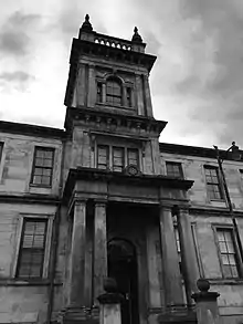 |
Key
The scheme for classifying buildings in Scotland is:
- Category A: "buildings of national or international importance, either architectural or historic; or fine, little-altered examples of some particular period, style or building type."[1]
- Category B: "buildings of regional or more than local importance; or major examples of some particular period, style or building type, which may have been altered."[1]
- Category C: "buildings of local importance; lesser examples of any period, style, or building type, as originally constructed or moderately altered; and simple traditional buildings which group well with other listed buildings."[1]
In March 2016 there were 47,288 listed buildings in Scotland. Of these, 8% were Category A, and 50% were Category B, with the remaining 42% being Category C.[2]
See also
Notes
- Sometimes known as OSGB36, the grid reference (where provided) is based on the British national grid reference system used by the Ordnance Survey.
• "Guide to National Grid". Ordnance Survey. Retrieved 12 December 2007.
• "Get-a-map". Ordnance Survey. Retrieved 17 December 2007. - Historic Environment Scotland assign a unique alphanumeric identifier to each designated site in Scotland, for listed buildings this always begins with "LB", for example "LB12345".
References
- All entries, addresses and coordinates are based on data from Historic Scotland. This data falls under the Open Government Licence
- "What is Listing?". Historic Environment Scotland. Retrieved 29 May 2018.
- Scotland's Historic Environment Audit 2016 (PDF). Historic Environment Scotland and the Built Environment Forum Scotland. pp. 15–16. Retrieved 29 May 2018.
This article is issued from Wikipedia. The text is licensed under Creative Commons - Attribution - Sharealike. Additional terms may apply for the media files.