List of listed buildings in Glasgow/5
List
| Name | Location | Date Listed | Grid Ref. [note 1] | Geo-coordinates | Notes | LB Number [note 2] | Image |
|---|---|---|---|---|---|---|---|
| 55-61 (Odd Nos) Buchanan Street (Known As 59 Buchanan Street) | 55°51′34″N 4°15′18″W | Category B | 32993 |  | |||
| 83, 85 Buchanan Street And 6 Mitchell Lane | 55°51′35″N 4°15′17″W | Category B | 32996 | | |||
| 249 Buchanan Street And 1-7 (Odd Nos) Sauchiehall Street "Cleland Testimonial Building" | 55°51′51″N 4°15′12″W | Category B | 33006 | | |||
| 39 Elmbank Crescent, Scottish Opera | 55°51′51″N 4°16′07″W | Category B | 33020 | | |||
| 1H Gilmorehill, University Of Glasgow, Materia Medica And Physiology Building | 55°52′15″N 4°17′33″W | Category B | 32924 | 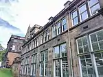 | |||
| 1L Gilmorehill, University Of Glasgow, Zoology Building | 55°52′17″N 4°17′35″W | Category A | 32928 | 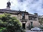 | |||
| 2-10 (Inclusive Nos) University Gardens | 55°52′23″N 4°17′25″W | Category A | 32931 | 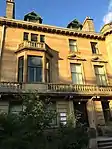 | |||
| 14 University Gardens | 55°52′24″N 4°17′27″W | Category A | 32933 | 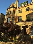 | |||
| 217-221 (Odd Nos) Argyle Street | 55°51′29″N 4°15′27″W | Category B | 32938 | | |||
| 335-345 (Odd Nos) Argyle Street And 80-92 (Even Nos) York Street | 55°51′31″N 4°15′44″W | Category B | 32940 | | |||
| 134-156 (Even Nos) Argyle Street, 2-6 (Even Nos) Mitchell Street And 3-7 (Odd Nos) Buchanan Street | 55°51′30″N 4°15′20″W | Category B | 32948 |  | |||
| 752-756 (Even Nos) Argyle Street And 3, 5, 7 Shaftesbury Street, Savings Bank Of Glasgow | 55°51′43″N 4°16′27″W | Category A | 32953 |  | |||
| 1102-1114 (Even Nos) Argyle Street And 3, 9 Kelvingrove Street | 55°51′54″N 4°17′05″W | Category B | 32955 | | |||
| 1264-1278 (Even Nos) Argyle Street And 5-13 (Odd Nos) Radnor Street | 55°52′00″N 4°17′23″W | Category B | 32956 | | |||
| 119, 121, Bath Street | 55°51′50″N 4°15′35″W | Category B | 32957 | | |||
| 51-59 (Odd Nos) Partickhill Road | 55°52′27″N 4°18′31″W | Category B | 32890 | | |||
| 56 Partickhill Road 'Woodbank', Carriage House, Arch To Service Court, Retaining Walls And Cast-Iron Gates | 55°52′28″N 4°18′31″W | Category A | 32895 | | |||
| 64, 66 Partickhill Road | 55°52′30″N 4°18′34″W | Category C(S) | 32897 | | |||
| 1-9 (Inclusive Nos) Ruskin Terrace, 1, 1A, 3 Hamilton Park Avenue | 55°52′35″N 4°17′01″W | Category A | 32903 | | |||
| 10-18 (Inclusive Nos) Ruskin Terrace, 2, 4, Ruskin Place | 55°52′36″N 4°17′05″W | Category B | 32904 | | |||
| 1 Gilmorehill, University Of Glasgow, Main Block: Quadrangles, Bute Hall, Randolph Hall, Hunterian Museum, Library | 55°52′19″N 4°17′20″W | Category A | 32913 | 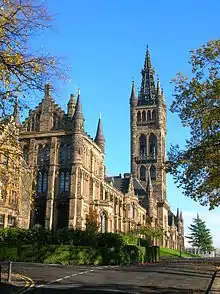 | |||
| 360-392 (Even Nos) Dumbarton Road, 4-8 (Even Nos) Peel Street, 1-13 (Odd Nos) Fortrose Street And 1 Burgh Hall Street | 55°52′15″N 4°18′30″W | Category B | 32861 | | |||
| 305 Dumbarton Road, Partick District Library | 55°52′14″N 4°18′17″W | Category C(S) | 32864 |  | |||
| 65-73 (Odd Nos) Highburgh Road | 55°52′28″N 4°18′06″W | Category B | 32877 | | |||
| 46-50 (Even Nos) Hyndland Street, St Peter's Rc Church And Presbytery | 55°52′21″N 4°18′06″W | Category B | 32880 | | |||
| 34-38 (Even Nos) West George Street And 1 And 1A Dundas Street | 55°51′43″N 4°15′10″W | Category B | 32801 | 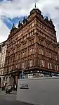 | |||
| 54-64 Wilson Street With 60-62 (Even Nos) Glassford Street And 69 Hutcheson Street | 55°51′32″N 4°14′55″W | Category B | 32808 | | |||
| Buchanan Street, At Royal Bank Place, Police Box | 55°51′38″N 4°15′15″W | Category B | 32825 | 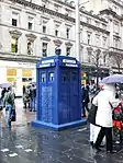 | |||
| 1-29 (Odd Nos) And 2-40 (Even Nos) Royal Exchange Square With 145-147 (Odd Nos) Queen Street And Archways | 55°51′38″N 4°15′08″W | Category A | 32826 | | |||
| St Enoch Square Travel Centre, Formerly St Enoch Underground Station | 55°51′27″N 4°15′19″W | Category A | 32833 | .jpg.webp) | |||
| 201 St James Road, Allan Glen's Secondary School Annexe, With Gatepiers Railings And 195 St James Road (Janitor's House) | 55°51′53″N 4°14′38″W | Category C(S) | 32834 | | |||
| 11-27 (Odd Nos) Saltmarket | 55°51′22″N 4°14′38″W | Category B | 32842 | | |||
| 5-27 (Odd Nos) Ashton Road | 55°52′27″N 4°17′38″W | Category B | 32846 | 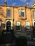 | |||
| 1-8 (Inclusive Nos) Belgrave Terrace, 2 Oakfield Avenue And 1, 3 Southpark Avenue | 55°52′33″N 4°17′03″W | Category B | 32848 | | |||
| 7, 9 Buckingham Street | 55°52′40″N 4°17′16″W | Category C(S) | 32849 | | |||
| 64-70 (Even Nos) Howard Street | 55°51′23″N 4°15′16″W | Category C(S) | 32726 | | |||
| 115-137 (Odd Nos) Ingram Street And 118-128 (Even Nos) Brunswick Street | 55°51′34″N 4°14′45″W | Category B | 32732 | | |||
| 56-64 (Even Nos) Ingram Street, And 132 Albion Street, Albion Buildings | 55°51′34″N 4°14′37″W | Category B | 32739 | | |||
| 124-140 (Even Nos) Ingram Street | 55°51′35″N 4°14′48″W | Category B | 32742 | | |||
| 170-176 (Even Nos) Ingram Street | 55°51′36″N 4°14′54″W | Category B | 32746 | | |||
| 3-11 (Odd Nos) James Morrison Street And 74-76 (Even Nos) London Road | 55°51′20″N 4°14′33″W | Category B | 32748 | 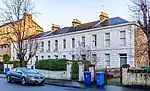 | |||
| 9-17 (Odd Nos) John Street And 47 Cochrane Street | 55°51′36″N 4°14′53″W | Category B | 32750 | | |||
| 84-92 (Even Nos) Miller Street | 55°51′35″N 4°15′02″W | Category B | 32763 | | |||
| 133-155 (Odd Nos) Stockwell Street, 128-138 (Even Nos) Bridgegate And 1-3 (Odd Nos) Aird's Lane | 55°51′18″N 4°15′00″W | Category B | 32767 | | |||
| 73-75 (Odd Nos) Trongate | 55°51′25″N 4°14′45″W | Category C(S) | 32770 | | |||
| 97-101 Trongate | 55°51′25″N 4°14′48″W | Category B | 32772 | | |||
| 100-104 (Even Nos) Trongate | 55°51′26″N 4°14′45″W | Category B | 32784 | 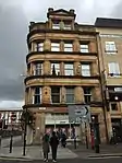 | |||
| 170-174 (Even Nos) Trongate And 10 Hutcheson Street | 55°51′27″N 4°14′53″W | Category B | 32788 | | |||
| Virginia Street, Virginia Court (Rear Of 37-47) | 55°51′32″N 4°15′01″W | Category B | 32794 | | |||
| 70 Cathedral Square, Glasgow Cathedral And Cathedral Graveyard, Boundary Walls And Railings | 55°51′50″N 4°14′04″W | Category A | 32654 | 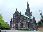 | |||
| Cathedral Square, Statue Of James Arthur | 55°51′46″N 4°14′10″W | Category B | 32656 | 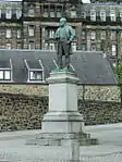 | |||
| Cathedral Square, Statue To Reverend Norman Macleod | 55°51′43″N 4°14′11″W | Category B | 32661 | 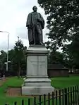 | |||
| 60 Fox Street | 55°51′23″N 4°15′18″W | Category B | 32681 | | |||
| 5 Garth Street With 79-83 (Odd Nos) Hutcheson Street | 55°51′33″N 4°14′53″W | Category C(S) | 32682 | | |||
| 11 George Square, Monteith House | 55°51′38″N 4°15′04″W | Category B | 32687 | | |||
| 40 George Square, Millennium (Formerly North British) Hotel | 55°51′42″N 4°15′01″W | Category B | 32690 | 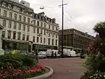 | |||
| 187 George Street, Montrose House | 55°51′39″N 4°14′41″W | Category B | 32707 | | |||
| 119-129 High Street | 55°51′31″N 4°14′32″W | Category B | 32721 | | |||
| 215 High Street And 7-9 (Odd Nos) Nicholas Street | 55°51′36″N 4°14′26″W | Category B | 32722 | 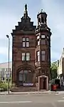 | |||
| 235-287 (Odd Nos) High Street, (Bell O'The Brae Tenements) | 55°51′39″N 4°14′20″W | Category B | 32723 | 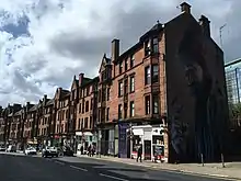 | |||
| 65-117 (Odd Nos) Argyle Street, Known As No 65 Argyle Street, Former Lewis's Department Store | 55°51′28″N 4°15′10″W | Category B | 32609 | 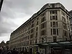 | |||
| 59-83 (Odd Nos) Bell Street And 6 Walls Street Known As 59 Bell Street | 55°51′29″N 4°14′36″W | Category B | 32621 | | |||
| 74 Brunswick Street And Return Elevation To Wilson Street | 55°51′30″N 4°14′49″W | Category C(S) | 32626 | | |||
| 108-114 (Even Nos) Brunswick Street And 87-99 (Odd Nos) Candleriggs | 55°51′33″N 4°14′48″W | Category B | 32628 | | |||
| 12 Buchanan Street | 55°51′31″N 4°15′16″W | Category B | 32630 | | |||
| 60-62 (Even Nos) Buchanan Street | 55°51′34″N 4°15′15″W | Category A | 32635 | 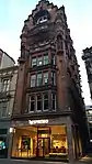 | |||
| 92-100 (Even Nos) Buchanan Street, Known As 98 Buchanan Street | 55°51′37″N 4°15′14″W | Category A | 32639 | 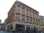 | |||
| 1 Victoria Circus (Thorncliffe) | 55°52′44″N 4°17′58″W | Category B | 32588 | | |||
| 35-37 (Odd Nos) Victoria Crescent Road, (Kings Gate) | 55°52′34″N 4°17′53″W | Category B | 32596 | | |||
| 10-16 (Even Nos) Kingsborough Gardens | 55°52′47″N 4°18′14″W | Category B | 32543 | | |||
| 1-7 (Inclusive Nos) Kirklee Gardens And Gatepiers | 55°53′00″N 4°17′45″W | Category B | 32547 | | |||
| 2, 2A And 4 Lorraine Road | 55°52′48″N 4°18′05″W | Category C(S) | 32561 | | |||
| 10 Lowther Terrace, With Gatepiers And Railings, Great Western Road | 55°52′53″N 4°17′56″W | Category A | 32564 | | |||
| 3-13 (Odd Nos) Mirrlees Drive | 55°52′56″N 4°17′47″W | Category B | 32566 | | |||
| 4, 4A And 6 Prince Albert Road And Gatepiers | 55°52′39″N 4°18′07″W | Category B | 32573 | | |||
| 1-7 (Inclusive Nos) Hughenden Terrace, Hughenden Road Boundary Walls And 5 And 6 Montague Lane | 55°52′53″N 4°18′22″W | Category B | 32527 | | |||
| 5-11 (Odd Nos) Kingsborough Gardens | 55°52′44″N 4°18′18″W | Category B | 32541 | | |||
| 1-5 (Inclusive Nos) Devonshire Gardens, With Boundary Walls And Gatepiers, Great Western Road | 55°52′56″N 4°18′15″W | Category B | 32495 | | |||
| 78-104 (Even Nos) Dowanhill Street And 38-40 (Even Nos) Highburgh Road | 55°52′29″N 4°17′56″W | Category B | 32498 | | |||
| 45-55 (Odd Nos) Dowanside Road And 106 Dowanhill Street | 55°52′31″N 4°17′54″W | Category B | 32499 | | |||
| 57-67 (Odd Nos) Dowanside Road And 115, Dowanhill Street | 55°52′32″N 4°17′58″W | Category B | 32500 | | |||
| 3 Dundonald Road (Bennochy Lodge) And Gatepiers | 55°52′42″N 4°17′52″W | Category B | 32505 | | |||
| 5-13 (Odd Nos) Dundonald Road, With Retaining Wall And Railings | 55°52′42″N 4°17′52″W | Category B | 32506 | | |||
| 1 And 2 Grosvenor Crescent | 55°52′41″N 4°17′34″W | Category B | 32518 | | |||
| 5-9 (Odd Nos) Bellshaugh Road And 1 And 1A Mirrlees Drive | 55°52′57″N 4°17′46″W | Category C(S) | 32477 | | |||
| 1-7 (Inclusive Nos) Bowmont Gardens, R C Training College | 55°52′40″N 4°17′53″W | Category B | 32478 | | |||
| 3 And 3A Cleveden Drive | 55°53′01″N 4°17′50″W | Category B | 32482 | | |||
| 2-10 (Even Nos) Cleveden Drive, 31 Cleveden Drive Lane And Former 11 Bellshaugh Road (Now Linked To 2 Mirrlees Drive) With Gatepiers Boundary And Retaining Walls | 55°52′59″N 4°17′48″W | Category C(S) | 32483 | | |||
| 15 Cleveden Gardens With Garage, Gatepiers, Gates, Walls And Railings | 55°53′05″N 4°17′59″W | Category A | 32486 | | |||
| 5-9 (Odd Nos) Crown Road South | 55°52′32″N 4°18′00″W | Category C(S) | 32492 | | |||
| 353, 357 And 361 Langside Road | 55°50′01″N 4°15′49″W | Category B | 32435 | 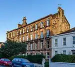 | |||
| 3-11 (Odd Nos) Queen Mary Avenue Including Gatepiers | 55°50′00″N 4°15′45″W | Category B | 32439 | 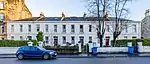 | |||
| 34-34A Queen Mary Avenue Crosshill | 55°49′58″N 4°15′41″W | Category B | 32441 |  | |||
| 40 And 40A Queen Mary Avenue | 55°49′57″N 4°15′39″W | Category C(S) | 32442 |  | |||
| 400, 404, 408 Victoria Road, 124, Allison Street | 55°50′11″N 4°15′54″W | Category B | 32464 |  | |||
| 794-802 (Even Nos) Pollokshaws Road, 1 Regent Park Square And 2 Queen Square | 55°50′09″N 4°16′19″W | Category B | 32404 |  | |||
| 178 Queen's Drive, Queens Park Baptist Church And Hall | 55°50′08″N 4°16′14″W | Category B | 32408 | %252C_Glasgow%252C_Scotland_02.jpg.webp) | |||
| 23-45 (Odd Nos) Albert Road, 318, 320 Langside Road | 55°50′05″N 4°15′52″W | Category B | 32416 |  | |||
| 34-50 (Even Nos) Albert Road | 55°50′03″N 4°15′51″W | Category B | 32417 |  | |||
| 17 Shakespeare Street, Ruchill Parish Church Halls And Janitor's House | 55°53′12″N 4°17′02″W | Category A | 32356 |  | |||
| 57, 59, 61 Cathkin Road Including Perimeter Walls And Gatepiers | 55°49′25″N 4°16′32″W | Category B | 32366 |  | |||
| Marywood Square Lamp Standard In Front Of No 23 | 55°50′07″N 4°16′29″W | Category B | 32377 | 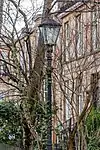 | |||
| Marywood Square Lamp Standard In Front Of No 40 | 55°50′09″N 4°16′32″W | Category B | 32381 | 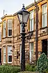 | |||
| Marywood Square Lamp Standard In Front Of No 50 | 55°50′10″N 4°16′34″W | Category B | 32382 | | |||
| 40, 40A-46 (Even Nos) Millbrae Crescent | 55°49′21″N 4°16′28″W | Category B | 32385 | | |||
| 11-17 And 17A (Inclusive Nos) Moray Place | 55°50′13″N 4°16′28″W | Category B | 32387 |  | |||
| 27-33 (Inclusive Nos) Moray Place And 57 Marywood Square | 55°50′10″N 4°16′37″W | Category B | 32389 | _Moray_Place_And_57_Marywood_Square%252C_Glasgow%252C_Scotland.jpg.webp) | |||
| 697 Pollokshaws Road, 5 Torrisdale Street, Bank Of Scotland Building | 55°50′10″N 4°16′12″W | Category B | 32398 |  | |||
| 425, 427 Crow Road | 55°52′47″N 4°19′31″W | Category C(S) | 32295 | | |||
| 28 ,30A, 30B, 30C, 32, 32A And 32B Victoria Park Gardens South, Broomhill Trinity Congregational Church And Halls | 55°52′38″N 4°19′32″W | Category B | 32298 | | |||
| 1097 Great Western Road, 5 Whittingehame Gardens | 55°53′11″N 4°18′58″W | Category C(S) | 32326 | | |||
| 1101 Great Western Road, 7 Whittingehame Gardens | 55°53′12″N 4°19′00″W | Category C(S) | 32328 | | |||
| 1000 Great Western Road, Glasgow Homoeopathic Hospital, Gatepiers And Retaining Walls | 55°53′02″N 4°18′22″W | Category B | 32335 | | |||
| 55 Mitre Road | 55°52′46″N 4°19′47″W | Category C(S) | 32338 | | |||
| 11 Whittinghame Drive, Garden Walls And Gatepiers | 55°53′05″N 4°18′54″W | Category A | 32342 | | |||
| 1508 Maryhill Road, Maryhill Public Library | 55°53′29″N 4°17′26″W | Category B | 32352 | | |||
| 1-8 Kingfisher Gardens, Former Glasgow University Sports Pavilion | 55°53′43″N 4°21′59″W | Category C(S) | 32275 | | |||
| 19 Westland Drive, Whiteinch Homes | 55°52′38″N 4°20′24″W | Category B | 32284 | | |||
| 23-41 (Odd Nos) Broomhill Drive And 1-15 (Odd Nos) Broomhill Avenue, With Gatepiers And Low Boundary Wall | 55°52′20″N 4°19′24″W | Category C(S) | 32289 | | |||
| 137-159 (Odd Nos) Broomhill Drive | 55°52′34″N 4°19′18″W | Category B | 32290 | | |||
| 6-10 (Inclusive) Broomhill Gardens | 55°52′32″N 4°19′16″W | Category B | 32292 | | |||
| 3-13 (Odd Nos) Crow Road And 482-492 (Even Nos) Dumbarton Road | 55°52′15″N 4°18′47″W | Category B | 32294 | | |||
| Queen's Crescent Gardens, Ornamental Fountain | 55°52′15″N 4°16′15″W | Category B | 32248 | | |||
| 24-40 (Even Nos) Westend Park Street | 55°52′14″N 4°16′28″W | Category C(S) | 32255 | | |||
| 9, 15, 21 Willowbank Street And 192, 194, 206 Woodlands Road | 55°52′15″N 4°16′33″W | Category B | 32260 | | |||
| 1-11 And 19 (Odd Nos) Lynedoch Street | 55°52′06″N 4°16′25″W | Category B | 32224 | | |||
| 31-39 (Odd Nos) Oakfield Avenue | 55°52′28″N 4°17′04″W | Category B | 32234 | | |||
| 1 - 5 (Odd Nos Inclusive) And 4 Park Gate | 55°52′10″N 4°16′49″W | Category A | 32242 | | |||
| 4-12 (Even Nos) Burnbank Gardens | 55°52′25″N 4°16′18″W | Category C(S) | 32183 | | |||
| Eldon Street Bridge Over River Kelvin | 55°52′20″N 4°16′53″W | Category B | 32188 | 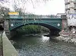 | |||
| 40-50 (Even Nos) Gibson Street And 84-86 (Even Nos) Otago Street | 55°52′22″N 4°16′59″W | Category B | 32191 | | |||
| 1-9 (Odd Nos) Great George Street And 78-80 (Even Nos) Otago Street | 55°52′23″N 4°16′59″W | Category B | 32195 | | |||
| 300 Great Western Road/Holyrood Crescent St Mary's Episcopal Cathedral | 55°52′25″N 4°16′30″W | Category A | 32198 | 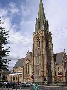 | |||
| Kelvingrove Park Gateway To Kelvingrove Street | 55°52′01″N 4°17′01″W | Category C(S) | 32208 | | |||
| Kelvingrove Park, South African War Memorial | 55°52′13″N 4°17′02″W | Category B | 32212 | 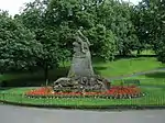 | |||
| 33-43 (Inclusive Nos) Lansdowne Crescent And 388-400 (Even Nos) Great Western Road | 55°52′28″N 4°16′38″W | Category B | 32218 | | |||
| 44 Ashley Street Woodside Public School, Albany Annexe | 55°52′12″N 4°16′20″W | Category B | 32175 | | |||
| 3-27 (Odd Nos) Bank Street | 55°52′30″N 4°16′57″W | Category B | 32177 |  | |||
| 6-16 (Even Nos) Bank Street | 55°52′31″N 4°16′58″W | Category B | 32179 | | |||
| 86- 90 Saracen Street, St Teresa's Roman Catholic Church And Presbytery Including Gateways, Boundary Walls, Railings, Steps And Piers | 55°52′48″N 4°15′08″W | Category B | 45981 | | |||
| Property To Rear Of 100 Brunswick Street, 85 Candleriggs Patrick Thomas Court | 55°51′31″N 4°14′47″W | Category B | 46590 | | |||
| 19 And 21 Aytoun Road With Conservatory | 55°50′32″N 4°16′55″W | Category B | 47412 |  | |||
| 70 Hyndland Road, Edward Viii Pillar Box | 55°52′47″N 4°18′20″W | Category B | 48024 | | |||
| La Belle Place, Kelvingrove Park Public Convenience And Shelter (Opposite Royal Terrace) | 55°52′01″N 4°16′49″W | Category C(S) | 48833 | | |||
| 520 Sauchiehall Street And 341 Renfrew Street Including Lamp Posts | 55°51′59″N 4°16′11″W | Category B | 49921 | | |||
| 61 Bridge Street | 55°51′11″N 4°15′30″W | Category B | 49930 | | |||
| 4 Rogart Street, Glasgow Metropolitan College, Rogart Street Campus, (Former Mavor & Coulson Stores Building) | 55°51′04″N 4°13′32″W | Category C(S) | 51735 | | |||
| Glencairn Drive, Titwood Bowling Clubhouse | 55°50′18″N 4°16′57″W | Category C(S) | 44655 | | |||
| Applecross Street, Forth And Clyde Canal Workshops | 55°52′38″N 4°15′42″W | Category B | 44020 | | |||
| 859 And 869 Crow Road, Temple Anniesland Parish Church (Church Of Scotland) With Hall, Gatepiers, Boundary Walls And Railings | 55°53′28″N 4°19′29″W | Category B | 43035 | |
Key
The scheme for classifying buildings in Scotland is:
- Category A: "buildings of national or international importance, either architectural or historic; or fine, little-altered examples of some particular period, style or building type."[1]
- Category B: "buildings of regional or more than local importance; or major examples of some particular period, style or building type, which may have been altered."[1]
- Category C: "buildings of local importance; lesser examples of any period, style, or building type, as originally constructed or moderately altered; and simple traditional buildings which group well with other listed buildings."[1]
In March 2016 there were 47,288 listed buildings in Scotland. Of these, 8% were Category A, and 50% were Category B, with the remaining 42% being Category C.[2]
See also
Notes
- Sometimes known as OSGB36, the grid reference (where provided) is based on the British national grid reference system used by the Ordnance Survey.
• "Guide to National Grid". Ordnance Survey. Retrieved 12 December 2007.
• "Get-a-map". Ordnance Survey. Retrieved 17 December 2007. - Historic Environment Scotland assign a unique alphanumeric identifier to each designated site in Scotland, for listed buildings this always begins with "LB", for example "LB12345".
References
- All entries, addresses and coordinates are based on data from Historic Scotland. This data falls under the Open Government Licence
- "What is Listing?". Historic Environment Scotland. Retrieved 29 May 2018.
- Scotland's Historic Environment Audit 2016 (PDF). Historic Environment Scotland and the Built Environment Forum Scotland. pp. 15–16. Retrieved 29 May 2018.
This article is issued from Wikipedia. The text is licensed under Creative Commons - Attribution - Sharealike. Additional terms may apply for the media files.