List of listed buildings in Glasgow/8
List
| Name | Location | Date Listed | Grid Ref. [note 1] | Geo-coordinates | Notes | LB Number [note 2] | Image |
|---|---|---|---|---|---|---|---|
| 28 Tunnel Street, Glasgow Harbour Tunnel, Otherwise Known As Finnieston Tunnel, Shaft And Rotunda | 55°51′31″N 4°17′00″W | Category B | 33203 | 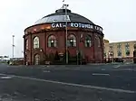 | |||
| 134, 136 Wellington Street, 105-113 (Odd Nos) Bath Street And 52 Bath Lane, Wellington Buildings | 55°51′50″N 4°15′32″W | Category B | 33219 |  | |||
| 91-95 (Odd Nos) West George Street And 53 West Nile Street | 55°51′43″N 4°15′19″W | Category B | 33222 | 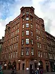 | |||
| 213 West George Street | 55°51′45″N 4°15′37″W | Category B | 33228 | | |||
| 57, 61 St Vincent Street | 55°51′40″N 4°15′18″W | Category B | 33131 | | |||
| 93 St Vincent Street And 20, 22 Renfield Street, Savings Bank Of Glasgow, (Bank Of Scotland Chambers) | 55°51′41″N 4°15′24″W | Category B | 33135 | 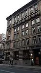 | |||
| 115, 117, St Vincent Street | 55°51′41″N 4°15′28″W | Category A | 33138 | 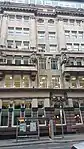 | |||
| 119-123 (Odd Nos) St Vincent Street And 112-118 (Even Nos) Hope Street, Liverpool And London And Globe Insurance Buildings | 55°51′41″N 4°15′29″W | Category B | 33139 |  | |||
| 84-94 (Even Nos) St Vincent Street | 55°51′42″N 4°15′21″W | Category A | 33153 | | |||
| 102, 104 St Vincent Street And 26, 26A And 26B Renfield Street | 55°51′42″N 4°15′23″W | Category B | 33155 |  | |||
| 232-234 (Even Nos) St Vincent Street | 55°51′45″N 4°15′47″W | Category B | 33164 | _ST_VINCENT_STREET(2).jpg.webp) | |||
| 119-121 (Odd Nos) Sauchiehall Street, Hope Street And Bath Street And Including Arch Over Sauchiehall Lane | 55°51′51″N 4°15′28″W | Category B | 33170 |  | |||
| 199-215 (Odd Nos) Sauchiehall Street And 289 West Campbell Street | 55°51′54″N 4°15′39″W | Category B | 33172 | | |||
| 63-77 (Odd Nos) Nelson Mandela Place, West George Street With 153-159 (Odd Nos) Buchanan Street, Former Glasgow Stock Exchange | 55°51′42″N 4°15′15″W | Category A | 33089 |  | |||
| 201 North Street, Kent Road, And Berkeley Street, Mitchell Library | 55°51′54″N 4°16′20″W | Category B | 33095 | 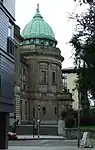 | |||
| 100 Stobcross Road, Queen's Dock, Former Hydraulic Pumping Station | 55°51′44″N 4°17′48″W | Category B | 33098 | | |||
| 203-217 (Odd Nos) Renfrew Street, Incorporated Dental Hospital | 55°51′59″N 4°15′59″W | Category B | 33106 | 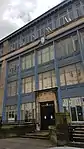 | |||
| 6 Rose Street | 55°51′56″N 4°15′41″W | Category B | 33117 | | |||
| 6 Gordon Street, Part Of Former Commercial Bank | 55°51′38″N 4°15′18″W | Category A | 33030 | | |||
| 42-44 (Even Nos) Jamaica Street 5-9 (Odd Nos) Midland Street | 55°51′26″N 4°15′27″W | Category B | 33066 | | |||
| 54-64 (Even Nos) Kelvingrove Street | 55°51′58″N 4°17′00″W | Category B | 33074 | | |||
| 23, 33, 43, 53 Kent Road | 55°51′52″N 4°16′25″W | Category B | 33077 | | |||
| 69 Kent Road (Former St Vincent Church Of Scotland) | 55°51′51″N 4°16′30″W | Category C(S) | 33078 | | |||
| 91 Buchanan Street | 55°51′36″N 4°15′17″W | Category A | 32998 | .jpg.webp) | |||
| 123-129 (Odd Nos) Buchanan Street, Carron Building | 55°51′39″N 4°15′16″W | Category B | 33001 | | |||
| 147 Buchanan Street And St Vincent Street, Former Western Club | 55°51′41″N 4°15′15″W | Category A | 33002 | 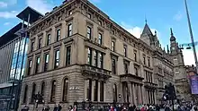 | |||
| 1E Gilmorehill, University Of Glasgow, Department Of Botany | 55°52′21″N 4°17′30″W | Category B | 32917 | 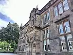 | |||
| 1 Gilmorehill, University Of Glasgow Lion And Unicorn Staircase | 55°52′17″N 4°17′24″W | Category A | 32922 | 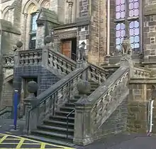 | |||
| 11-13 (Odd Nos) University Gardens | 55°52′23″N 4°17′29″W | Category B | 32930 | | |||
| 21-43 (Odd Nos) Ashton Lane, Mews Cottages Including Grosvenor Cafe | 55°52′28″N 4°17′35″W | Category C(S) | 32936 | | |||
| 361-371 (Odd Nos) Argyle Street And 80 James Watt Street | 55°51′31″N 4°15′49″W | Category B | 32942 | | |||
| 1087-1119 (Odd Nos) Argyle Street | 55°51′52″N 4°17′03″W | Category B | 32943 | | |||
| 1155-1163 (Odd Nos) Argyle Street | 55°51′54″N 4°17′08″W | Category C(S) | 32945 | | |||
| 1287-1323 (Odd Nos) Argyle Street | 55°52′00″N 4°17′26″W | Category C(S) | 32947 | | |||
| 316-336 (Even Nos) Argyle Street, Blythswood Hotel Including "Duke Of Wellington" Public House | 55°51′32″N 4°15′42″W | Category B | 32951 | | |||
| 181-199 (Odd Nos) Bath Street And Blythswood Street | 55°51′52″N 4°15′47″W | Category A | 32960 | 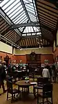 | |||
| 52 Partickhill Road, 9 Partickhill Court | 55°52′28″N 4°18′28″W | Category B | 32894 | | |||
| 53-63 (Odd Nos) Peel Street | 55°52′24″N 4°18′39″W | Category B | 32899 | | |||
| 65-73 (Odd Nos) Southpark Avenue | 55°52′24″N 4°17′12″W | Category C(S) | 32906 | | |||
| 1D Gilmorehill, University Of Glasgow, Anatomical Building | 55°52′17″N 4°17′13″W | Category B | 32916 | | |||
| 78 Church Street, 10B Dumbarton Road, Western Infirmary, Pathological Block, And Boundary Wall | 55°52′20″N 4°17′48″W | Category B | 32858 | | |||
| Kelvingrove Park Monument to Lord Kelvin | 55°52′11″N 4°17′13″W | Category B | 32881 | 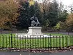 | |||
| 51 Wilson Street | 55°51′30″N 4°14′51″W | Category B | 32805 | | |||
| 40-50 (Even Nos) Wilson Street With 70-74 Hutcheson Street, 117 Brunswick Street, 149 Ingram Street (The Former County Buildings Or Court Houses) | 55°51′34″N 4°14′51″W | Category B | 32807 | 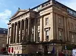 | |||
| 52 Parson Street, St Mungo's Retreat With Retaining Walls, Piers, Gates And Railings | 55°51′56″N 4°14′15″W | Category B | 32813 | | |||
| Royal Exchange Square, Royal Bank Of Scotland | 55°51′37″N 4°15′13″W | Category A | 32827 |  | |||
| 1-15 (Odd Nos) St Vincent Place With 159-161 (Odd Nos) Queen Street | 55°51′39″N 4°15′08″W | Category B | 32835 | | |||
| 168-182 (Even Nos) Saltmarket And 4, 6, 8 Jocelyn Square | 55°51′16″N 4°14′47″W | Category B | 32843 | | |||
| 23-33 (Odd Nos) Ingram Street | 55°51′32″N 4°14′32″W | Category B | 32731 | | |||
| 191 Ingram Street, Lanarkshire House, Corinthian (Former Sheriff Court And Justice Of Peace Court) | 55°51′34″N 4°14′59″W | Category A | 32735 |  | |||
| 158 Ingram Street, And 2 John Street, Hutcheson's Hospital | 55°51′36″N 4°14′51″W | Category A | 32744 |  | |||
| 162-168 (Even Nos) Ingram Street | 55°51′36″N 4°14′53″W | Category B | 32745 | | |||
| 10-26 (Even Nos) King Street And 62 Parnie Street | 55°51′24″N 4°14′48″W | Category B | 32753 | | |||
| 77-81 (Odd Nos) Miller Street, Arthur's Warehouse | 55°51′34″N 4°15′04″W | Category A | 32759 | | |||
| 16-22 (Even Nos) Montrose Street | 55°51′37″N 4°14′43″W | Category B | 32765 | | |||
| 130-138 (Even Nos) Trongate | 55°51′27″N 4°14′50″W | Category B | 32786 | | |||
| Cathedral Square, Statue Of James White Of Overtoun | 55°51′46″N 4°14′11″W | Category B | 32657 | 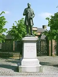 | |||
| 168 Clyde Street And Fox Lane, St Andrew's Roman Catholic Cathedral | 55°51′20″N 4°15′10″W | Category A | 32666 | 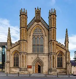 | |||
| Clyde Street, Victoria Bridge | 55°51′14″N 4°15′04″W | Category A | 32669 |  | |||
| 266-268 Clyde Street | 55°51′22″N 4°15′20″W | Category B | 32671 | 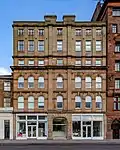 | |||
| 29 Cochrane Street And 18 John Street Formerly The John Street Church | 55°51′36″N 4°14′51″W | Category A | 32672 | 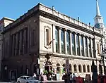 | |||
| 20-40 (Even Nos) Cochrane Street, 20 John Street And 233-235 (Odd Nos) George Street, Extension To The City Chambers, And Paired Screen Archways Over John Street | 55°51′40″N 4°14′51″W | Category A | 32675 | 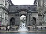 | |||
| George Square, The Cenotaph | 55°51′40″N 4°14′58″W | Category B | 32692 | 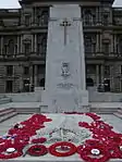 | |||
| George Square, Walter Scott Memorial Column | 55°51′40″N 4°15′01″W | Category A | 32696 | 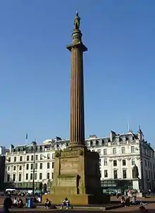 | |||
| George Square, James Watt Statue | 55°51′40″N 4°15′04″W | Category A | 32697 | 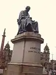 | |||
| George Square, James Oswald Statue | 55°51′40″N 4°15′02″W | Category B | 32699 | 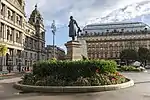 | |||
| George Square, Prince Albert Statue | 55°51′40″N 4°15′04″W | Category A | 32701 | .jpg.webp) | |||
| 61-65 (Odd Nos) High Street And Bell Street, (Bows Emporium) | 55°51′28″N 4°14′35″W | Category B | 32719 | | |||
| 24-26 (Even Nos) Cleveden Road | 55°53′06″N 4°18′09″W | Category C(S) | 32606 | | |||
| 122-132 (Even Nos) Argyle Street With 2-8 Buchanan Street | 55°51′30″N 4°15′16″W | Category B | 32618 |  | |||
| 45-51 (Odd Nos) Bell Street With 62-80 (Even Nos) Albion Street And 5-19 (Odd Nos) Walls Street Including Former Cheese Market | 55°51′29″N 4°14′38″W | Category B | 32620 | | |||
| 1-5 (Odd Nos) Blackfriars Street And 97-101 (Odd Nos) High Street | 55°51′30″N 4°14′33″W | Category B | 32624 | | |||
| 2 Queens Place (Westdel), 10 Kinnoul Lane And 10 Crown Road North, (Royston); With Boundary Walls And Gatepiers | 55°52′35″N 4°18′00″W | Category B | 32579 | .jpg.webp) | |||
| 4 And 4A Sydenham Road | 55°52′45″N 4°18′12″W | Category B | 32586 | | |||
| 13-41 (Odd Nos) Kingsborough Gardens | 55°52′40″N 4°18′19″W | Category B | 32542 | | |||
| 730 Great Western Road; Botanic Gardens Glass Houses | 55°52′46″N 4°17′25″W | Category B | 32512 | | |||
| 8, 9 And 10 Bowmont Gardens | 55°52′38″N 4°17′54″W | Category C(S) | 32479 | | |||
| 16 Cleveden Road, With Garden Walls And Gatepiers | 55°53′03″N 4°18′06″W | Category B | 32488 | | |||
| 75 Grange Road, Former Teachers' Resource And Computer Centre (Former Queen's Park School) Including Gates And Railings | 55°49′40″N 4°15′54″W | Category B | 32433 | | |||
| 335-347 (Odd Nos) Langside Road | 55°50′01″N 4°15′48″W | Category B | 32434 |  | |||
| 334, 336 And 346 Langside Road | 55°50′02″N 4°15′50″W | Category B | 32436 |  | |||
| 24 Queen's Drive The Knowe Including Gatepiers | 55°49′53″N 4°15′34″W | Category C(S) | 32446 |  | |||
| 26, 28 Queen's Drive Including Gatepiers | 55°49′54″N 4°15′35″W | Category B | 32447 | 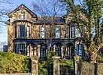 | |||
| 415-447 (Odd Nos) Victoria Road | 55°50′10″N 4°15′53″W | Category B | 32460 | 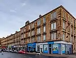 | |||
| 509-515 (Odd Nos) Victoria Road And 4 Albert Road | 55°50′04″N 4°15′55″W | Category B | 32462 | 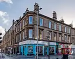 | |||
| 822-830 (Even Nos) Pollokshaws Road, 2 Marywood Square And 1 Queen Square | 55°50′06″N 4°16′23″W | Category B | 32405 | _Pollokshaws_Road%252C_Glasgow%252C_Scotland.jpg.webp) | |||
| Albert Road, 60 Dixon Road, Holyrood Rc School Including Janitor's Lodge And Playground Walls | 55°49′58″N 4°15′09″W | Category B | 32415 | 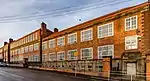 | |||
| 47 Bankhall Street, Shoe Warehouse (Former Govanhill Picture House) | 55°50′10″N 4°15′22″W | Category B | 32425 |  | |||
| 318 Calder Street And Hollybrook Street, Holy Cross Primary School | 55°50′10″N 4°15′18″W | Category B | 32426 | 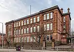 | |||
| 16 Algie Street, 122 Langside Avenue And Battle Place, Langside Hill Church And Boundary Walls And Gatepiers | 55°49′40″N 4°16′18″W | Category B | 32358 | 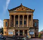 | |||
| 54 Cleveden Drive, Boundary Walls And Gatepiers | 55°53′03″N 4°18′20″W | Category B | 32309 | | |||
| 1103 Great Western Road, 8 Whittingehame Gardens | 55°53′12″N 4°19′02″W | Category C(S) | 32329 | | |||
| 996 Great Western Road, "Glendoune", Boundary Walls And Gatepiers | 55°53′00″N 4°18′16″W | Category B | 32333 | | |||
| 146 Southbrae Drive | 55°53′02″N 4°20′37″W | Category B | 32340 | | |||
| 10 Gairbraid Avenue, Maryhill Burgh Halls (Now Maryhill Community Centre) | 55°53′27″N 4°17′27″W | Category B | 32349 | 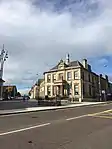 | |||
| Woodside Crescent/Sauchiehall Street, Cameron Memorial Fountain | 55°51′59″N 4°16′20″W | Category B | 32269 | 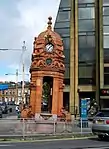 | |||
| 19,21,23,25,27,29, Squire Street And 69 Northinch Street, Former Whiteinch Jordanvale Parish Church And Hall | 55°52′21″N 4°20′05″W | Category B | 32282 | | |||
| 17-41 (Odd Nos) West Princes Street | 55°52′12″N 4°16′11″W | Category B | 32256 | | |||
| 49 West Princes Street | 55°52′13″N 4°16′13″W | Category B | 32257 | | |||
| 311 Woodlands Road, Woodside Public School | 55°52′20″N 4°16′44″W | Category B | 32263 | 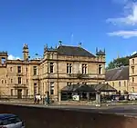 | |||
| 25 Lynedoch Street | Category B | 32227 | 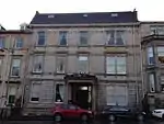 | ||||
| 27 Lynedoch Street | 55°52′06″N 4°16′32″W | Category B | 32228 | | |||
| 2-8 (Even Nos) Melrose Street | 55°52′17″N 4°16′14″W | Category B | 32229 | | |||
| Colebrooke Street Glasgow Academy | 55°52′33″N 4°16′46″W | Category B | 32186 | | |||
| 471 Great Western Road Savings Bank, Hillhead | 55°52′31″N 4°16′54″W | Category C(S) | 32201 | | |||
| 416 And 420 Great Western Road/433 North Woodside Road Lansdowne Parish Church (Church Of Scotland) | 55°52′28″N 4°16′41″W | Category A | 32205 | 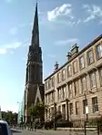 | |||
| 24-28 (Even Nos) Herbert Street (Herbert House) | 55°52′30″N 4°16′30″W | Category B | 32207 | | |||
| 20-30 (Even Nos) Bank Street And 15-19 (Odd Nos) Glasgow Street | 55°52′27″N 4°17′01″W | Category B | 32180 | | |||
| Kelvingrove Park, Kelvin Way, Kelvingrove Bandstand And Amphitheatre | 55°52′10″N 4°17′09″W | Category B | 46592 | 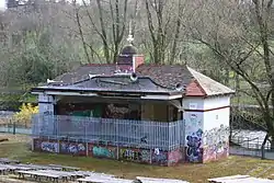 | |||
| Carmunnock Road And Glenacre Terrace, Castlemilk West Parish Church (Church Of Scotland) | 55°48′25″N 4°14′33″W | Category B | 48026 |  | |||
| 685 Alexandra Parade St Andrew's East Church Hall And Railings | 55°51′47″N 4°12′30″W | Category A | 48569 | | |||
| 229 Woodlands Road, Woodlands Methodist Church (Former Swedenborgian New Jerusalem Church) Including Boundary Wall And Gatepiers | 55°52′15″N 4°16′37″W | Category B | 48629 | | |||
| 87 Renfield Street And 49 Bath Street, Former Refuge Assurance Buildings Including Railings | 55°51′49″N 4°15′22″W | Category C(S) | 48630 | | |||
| 56 Langside Drive, Scott House | 55°48′54″N 4°16′43″W | Category B | 49639 | | |||
| 11, 13 And 15 Bath Street, Albert Chambers | 55°51′48″N 4°15′14″W | Category B | 49919 | | |||
| 860 Cumbernauld Road, St Enoch Hogganfield Church Of Scotland Church Including Hall | 55°52′04″N 4°11′31″W | Category C(S) | 49922 |  | |||
| 45 South Portland Street And 100 Norfolk Street, Deaf Connections Centre (Former Gorbals Public Library) | 55°51′10″N 4°15′23″W | Category B | 49979 | | |||
| 168 Renfrew Street, 18-26 Scott Street, Glasgow School Of Art, Assembly Building | 55°51′59″N 4°15′51″W | Category C(S) | 50513 | | |||
| 3 Tinto Road Including Water Garden, Boundary Walls And Gatepiers | 55°48′57″N 4°17′27″W | Category C(S) | 50820 | | |||
| Corner Of Great George Street And Cecil Street, Edward Viii Post Box | 55°52′29″N 4°17′19″W | Category B | 51529 | | |||
| 100 Elderpark Street, Craigton Road, Nimmo Drive, Elderpark Workspace (Former Galbraith Stores Bakery) | 55°51′28″N 4°19′22″W | Category C(S) | 51648 | | |||
| Victoria Park, Partick And Whiteinch War Memorial | 55°52′32″N 4°19′58″W | Category C(S) | 51739 | | |||
| 38 First Gardens With Boundary Walls And Fence | 55°50′36″N 4°18′37″W | Category C(S) | 44601 | | |||
| 340-344 (Even Nos) Argyle Street | 55°51′32″N 4°15′44″W | Category B | 44045 | | |||
| 583 And 585 Anniesland Road, Sherwood And Ainslea With Boundary Walls And Gates | 55°53′07″N 4°21′07″W | Category B | 43386 | | |||
| 8-22 (Even Nos) Prospecthill Grove, Former Langside College (Main Block) And Gatepiers | 55°49′38″N 4°15′44″W | Category B | 43001 |  | |||
| 4 Bayfield Terrace, St Pius X Roman Catholic Church With Presbytery, Boundary Walls, Gates And Railings | 55°54′49″N 4°21′52″W | Category B | 43031 |  | |||
| 60 Knightswood Road, Knightswood Secondary School With Railings | 55°53′27″N 4°20′17″W | Category B | 43037 | | |||
| 2025 Pollokshaws Road And Bengal Street, Pollokshaws Burgh Hall | 55°49′31″N 4°17′54″W | Category A | 33953 | | |||
| 1120 Pollokshaws Road, Shawlands Old Parish Church Including Hall | 55°49′49″N 4°16′58″W | Category B | 33957 | | |||
| Pollokshaws Road, Viaduct Over River Cart | 55°49′29″N 4°18′02″W | Category B | 33958 | | |||
| Pollokshaws Road, Railway Underbridge To South Of Pollockshaws West Station | 55°49′23″N 4°18′09″W | Category B | 33960 | | |||
| 71 Milnpark Street, Former Kingston Engine Works | 55°51′05″N 4°16′55″W | Category B | 33970 | | |||
| 136, 220 Armadale Street And Alexandra Parade, Alexandra Parade Public School Including Lodge, Playground Walls And Gatepiers | 55°51′48″N 4°12′58″W | Category B | 33886 | | |||
| 22 Craigpark, Including Wall And Gatepiers | 55°51′41″N 4°13′18″W | Category B | 33894 | | |||
| Ladywell Street, Lady Well | 55°51′39″N 4°13′57″W | Category B | 33902 | | |||
| 12 Whitehill Street, Roslea Drive, Dennistoun Blackfriars Parish Church, Halls And Church Officer's House | 55°51′32″N 4°13′07″W | Category B | 33911 | | |||
| 1 Barrhead Road, Junction With Pollokshaws Road And Nether Auldhouse Road, Toll House Formerly 1 Cross Street | 55°49′16″N 4°18′12″W | Category B | 33915 | | |||
| 14 Hector Road Including Gatepiers And Boundary Walls | 55°49′39″N 4°17′25″W | Category B | 33924 | | |||
| 32 Langside Avenue And Deanston Drive, St Helen`S Rc Church And Hall | 55°49′51″N 4°16′41″W | Category C(S) | 33929 |  | |||
| 81 Langside Drive, Stoneleigh | 55°48′47″N 4°16′39″W | Category B | 33932 | | |||
| Lochlea Road, K6 Telephone Kiosk | 55°49′19″N 4°17′24″W | Category B | 33937 | | |||
| 141 Merrylee Road, Telephone Exchange | 55°48′52″N 4°16′04″W | Category B | 33939 | | |||
| 18 Moss-Side Road, Frankfort Street, Bertram Street, Former Waverley Cinema | 55°49′52″N 4°16′54″W | Category A | 33941 |  | |||
| 25 Greenhead Street, 3-23 (Odd Nos) Macphail Street | 55°50′56″N 4°13′56″W | Category B | 33844 | | |||
| 67-73 (Odd Nos) Greenhead Street Including Gatepiers And Railings | 55°50′52″N 4°13′53″W | Category C(S) | 33848 | | |||
| 15-23 (Odd Nos) London Road And 26 Gallowgate, Mercat Building | 55°51′23″N 4°14′35″W | Category A | 33851 | | |||
| 92-106 (Even Nos) Tobago Street | 55°51′08″N 4°13′49″W | Category B | 33859 | | |||
| 826 Cumbernauld Road, Smithycroft Road, St Thomas The Apostle Rc Church | 55°52′01″N 4°11′33″W | Category B | 33867 | | |||
| Alexandra Parade, Fountain At Gate To Alexandra Park | 55°51′47″N 4°12′35″W | Category B | 33881 |  | |||
| 368 Alexandra Parade, Wd & Ho Wills Tobacco Factory | 55°51′49″N 4°13′23″W | Category B | 33883 | |
Key
The scheme for classifying buildings in Scotland is:
- Category A: "buildings of national or international importance, either architectural or historic; or fine, little-altered examples of some particular period, style or building type."[1]
- Category B: "buildings of regional or more than local importance; or major examples of some particular period, style or building type, which may have been altered."[1]
- Category C: "buildings of local importance; lesser examples of any period, style, or building type, as originally constructed or moderately altered; and simple traditional buildings which group well with other listed buildings."[1]
In March 2016 there were 47,288 listed buildings in Scotland. Of these, 8% were Category A, and 50% were Category B, with the remaining 42% being Category C.[2]
See also
Notes
- Sometimes known as OSGB36, the grid reference (where provided) is based on the British national grid reference system used by the Ordnance Survey.
• "Guide to National Grid". Ordnance Survey. Retrieved 12 December 2007.
• "Get-a-map". Ordnance Survey. Retrieved 17 December 2007. - Historic Environment Scotland assign a unique alphanumeric identifier to each designated site in Scotland, for listed buildings this always begins with "LB", for example "LB12345".
References
- All entries, addresses and coordinates are based on data from Historic Scotland. This data falls under the Open Government Licence
- "What is Listing?". Historic Environment Scotland. Retrieved 29 May 2018.
- Scotland's Historic Environment Audit 2016 (PDF). Historic Environment Scotland and the Built Environment Forum Scotland. pp. 15–16. Retrieved 29 May 2018.
This article is issued from Wikipedia. The text is licensed under Creative Commons - Attribution - Sharealike. Additional terms may apply for the media files.