List of listed buildings in Golspie, Highland
List
| Name | Location | Date Listed | Grid Ref. [note 1] | Geo-coordinates | Notes | LB Number [note 2] | Image |
|---|---|---|---|---|---|---|---|
| Little Ferry Pier And Boathouse | 57°56′01″N 4°01′07″W | Category C(S) | 7017 |  | |||
| Strathsteven Cottages | 57°59′27″N 3°53′40″W | Category C(S) | 7023 | | |||
| Golspie Fountain Street Duchess/Countess (Elizabeth) Sutherland Memorial Fountain | 57°58′31″N 3°58′41″W | Category B | 7029 | | |||
| Golspie Main Street Co-Op Drapery | 57°58′23″N 3°58′35″W | Category B | 7037 | | |||
| Dunrobin Castle Garden Pavilion (Museum) And Walled Garden | 57°58′56″N 3°56′33″W | Category A | 7045 | 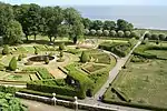 | |||
| Dunrobin Castle North Entrance, Stables, Carriage House And Lodges | 57°59′08″N 3°56′51″W | Category B | 7052 | | |||
| Dunrobin Mains Kennels | 57°59′15″N 3°57′01″W | Category B | 7058 | | |||
| Strathsteven Lodge | 57°59′19″N 3°54′05″W | Category C(S) | 7025 | | |||
| Golspie Main Street The Cottage (R) Newton (L) (Former Police Station) | 57°58′29″N 3°58′23″W | Category C(S) | 7032 | | |||
| Golspie, Main Street, Seacrest And Shop (R) Helenville (L) | 57°58′28″N 3°58′22″W | Category C(S) | 7038 | | |||
| Golspie Main Street Clach Ruach (R) Anvil House (L) | 57°58′29″N 3°58′20″W | Category C(S) | 7039 | | |||
| Golspie Main Street Messrs Lindsay | 57°58′29″N 3°58′20″W | Category C(S) | 7040 | | |||
| Dunrobin, Old Barn Cottages | 57°59′22″N 3°55′19″W | Category B | 7057 | | |||
| Golspie, Old Bank Street, T.A.Hall | 57°58′41″N 3°57′48″W | Category B | 12951 | | |||
| Golspie Old Bank Street Macleod House (Education Hostel) | 57°58′38″N 3°57′54″W | Category C(S) | 7006 | | |||
| Golspie Old Bank Street, The Sutherland Arms Hotel | 57°58′42″N 3°57′50″W | Category B | 7007 | | |||
| Golspie 1 And 2, Review Park | 57°59′06″N 3°57′03″W | Category B | 7011 | | |||
| Golspie Station Road, Old Heavitree Farm | 57°58′19″N 3°58′50″W | Category B | 7013 | | |||
| Kirkton | 57°57′41″N 4°01′45″W | Category C(S) | 7014 | | |||
| Little Ferry Mr Urquhart's House | 57°56′03″N 4°01′07″W | Category C(S) | 7016 | | |||
| Golspie Duke Street. The Wee Shop And Nos 1 And 2 | 57°58′33″N 3°57′57″W | Category B | 7027 | | |||
| Dunrobin Castle Dovecote | 57°58′51″N 3°56′49″W | Category B | 7047 | | |||
| Dunrobin Castle Flagstaff Lodge And Gate Piers | 57°58′48″N 3°57′26″W | Category B | 7049 | | |||
| Golspie Church Street Free Church And Former Free Church School | 57°58′11″N 3°59′03″W | Category B | 7061 | | |||
| Mound Bridge And Keeper's Cottage | 57°57′24″N 4°04′13″W | Category A | 7022 | | |||
| Uppat James Loch Memorial | 57°59′27″N 3°54′28″W | Category B | 7026 | | |||
| Golspie, Fountain Road, Lochnagarry | 57°58′29″N 3°58′36″W | Category B | 7028 | | |||
| Golspie Main Street James Fraser Shop | 57°58′25″N 3°58′33″W | Category B | 7030 | 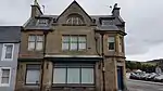 | |||
| Golspie Main Street Glen Coul (R) Gairloch (L) | 57°58′23″N 3°58′39″W | Category B | 7031 | | |||
| Golspie Main Street The Hollies | 57°58′33″N 3°58′05″W | Category B | 7035 | | |||
| Dunrobin Castle | 57°58′54″N 3°56′44″W | Category A | 7044 | 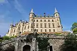 | |||
| Dunrobin Castle Private Burial Ground | 57°59′01″N 3°56′18″W | Category B | 7053 | | |||
| Dunrobin Mains Dunrobin Farmhouse And Keeper's Cottage | 57°59′13″N 3°57′03″W | Category B | 7056 | | |||
| Golspie Railway Station | 57°58′17″N 3°59′13″W | Category B | 7009 | | |||
| Little Ferry "Bertha's House" And Store To Rear | 57°56′02″N 4°01′05″W | Category C(S) | 7018 | | |||
| Littleferry Ice House | 57°56′04″N 4°01′07″W | Category B | 7019 | | |||
| Uppat House And South Gate Piers | 57°59′53″N 3°54′46″W | Category B | 7024 | | |||
| Golspie Old Bank Street Ben Bhraggie Hotel | 57°58′35″N 3°57′57″W | Category C(S) | 7043 | | |||
| Dunrobin Castle Dairy Cottage And Former Milking Parlour | 57°58′44″N 3°57′01″W | Category B | 7046 | | |||
| Ben Bhragaidh Monument To First Duke Of Sutherland | 57°58′54″N 4°00′24″W | Category B | 7063 | | |||
| Drummuie | 57°58′12″N 3°59′56″W | Category B | 7064 | | |||
| Golspie Railway Viaduct Over Golspie Burn | 57°58′51″N 3°57′45″W | Category B | 7010 | | |||
| Golspie Main Street St Andrew's Parish Church (Church Of Scotland And Burial Ground) | 57°58′33″N 3°58′00″W | Category A | 7036 | 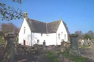 | |||
| Golspie Main Street Ford Park (Former Church Of Scotland Manse) | 57°58′31″N 3°57′57″W | Category B | 7041 | | |||
| Golspie Mill | 57°58′47″N 3°57′41″W | Category B | 7042 | | |||
| Dunrobin Castle Tower Lodge | 57°58′33″N 3°57′49″W | Category B | 7055 | | |||
| Golspie Bridge Over Golspie Burn | 57°58′44″N 3°57′45″W | Category B | 7060 | | |||
| Dunrobin, Sportsman's Walk Cottage | 57°59′18″N 3°56′57″W | Category C(S) | 7062 | | |||
| Golspie Old Bank Street 1 And 2, Drill Hall Cottages | 57°58′41″N 3°57′50″W | Category B | 7008 | | |||
| Little Ferry Ferry Cottage | 57°56′03″N 4°01′09″W | Category C(S) | 7015 | | |||
| Little Ferry Former Girnel, Now Cottages | 57°56′03″N 4°01′29″W | Category B | 7020 | | |||
| Morvich Lodge (Strath Fleet) | 57°58′43″N 4°06′28″W | Category B | 7021 | | |||
| Golspie Main Street, Clydesdale Bank | 57°58′29″N 3°58′21″W | Category C(S) | 7033 | | |||
| Golspie Main Street Bank Of Scotland | 57°58′32″N 3°58′13″W | Category C(S) | 7034 | | |||
| Dunrobin Castle, Duchess Harriet Memorial | 57°58′51″N 3°57′05″W | Category B | 7048 | | |||
| Dunrobin Mains Fisherman's Bothy/Rod Room (Immediately East Of Kennels) | 57°59′14″N 3°57′00″W | Category B | 7059 | | |||
| Drummuie, Golspie Technical School | 57°58′11″N 4°00′00″W | Category B | 7065 | | |||
| Post Office,Main Street,Golspie | 57°58′30″N 3°58′14″W | Category C(S) | 12916 | | |||
| Golspie, Main Street, Smiddy To Rear Of Anvil House | 57°58′28″N 3°58′20″W | Category B | 7005 | | |||
| Golspie Rhives House | 57°58′37″N 3°58′57″W | Category B | 7012 | | |||
| Dunrobin Castle Ice House | 57°58′55″N 3°56′51″W | Category C(S) | 7050 | | |||
| Dunrobin Castle Monument, 2Nd Duke Of Sutherland | 57°59′09″N 3°56′52″W | Category B | 7051 | | |||
| Dunrobin Castle Station Waiting Room | 57°59′09″N 3°56′50″W | Category B | 7054 | |
Key
The scheme for classifying buildings in Scotland is:
- Category A: "buildings of national or international importance, either architectural or historic; or fine, little-altered examples of some particular period, style or building type."[1]
- Category B: "buildings of regional or more than local importance; or major examples of some particular period, style or building type, which may have been altered."[1]
- Category C: "buildings of local importance; lesser examples of any period, style, or building type, as originally constructed or moderately altered; and simple traditional buildings which group well with other listed buildings."[1]
In March 2016 there were 47,288 listed buildings in Scotland. Of these, 8% were Category A, and 50% were Category B, with the remaining 42% being Category C.[2]
See also
Notes
- Sometimes known as OSGB36, the grid reference (where provided) is based on the British national grid reference system used by the Ordnance Survey.
• "Guide to National Grid". Ordnance Survey. Retrieved 2007-12-12.
• "Get-a-map". Ordnance Survey. Retrieved 2007-12-17. - Historic Environment Scotland assign a unique alphanumeric identifier to each designated site in Scotland, for listed buildings this always begins with "LB", for example "LB12345".
References
- All entries, addresses and coordinates are based on data from Historic Scotland. This data falls under the Open Government Licence
- "What is Listing?". Historic Environment Scotland. Retrieved 29 May 2018.
- Scotland's Historic Environment Audit 2016 (PDF). Historic Environment Scotland and the Built Environment Forum Scotland. pp. 15–16. Retrieved 29 May 2018.
This article is issued from Wikipedia. The text is licensed under Creative Commons - Attribution - Sharealike. Additional terms may apply for the media files.