List of listed buildings in Inveravon, Moray
List
| Name | Location | Date Listed | Grid Ref. [note 1] | Geo-coordinates | Notes | LB Number [note 2] | Image |
|---|---|---|---|---|---|---|---|
| Mary-Park Farmhouse | 57°25′52″N 3°20′07″W | Category B | 8475 |  | |||
| Tombae, Roman Catholic Church Of The Incarnation And Burial Ground | 57°18′54″N 3°18′04″W | Category A | 8476 | .jpg.webp) | |||
| Ballindalloch Castle, Bow Cottage | 57°24′51″N 3°21′59″W | Category B | 8482 | | |||
| Inveravon Parish Church (Church Of Scotland) Burial Ground And Gatepiers | 57°25′16″N 3°21′43″W | Category B | 8488 | | |||
| Ballindalloch Castle, Former Mains Farm, Stables And Cartsheds | 57°24′48″N 3°22′01″W | Category B | 8451 | | |||
| Ballindalloch Castle, Swiss Cottage | 57°24′24″N 3°21′44″W | Category A | 8460 | | |||
| Braes Of Glenlivet, Buiternach Burial Ground | 57°17′10″N 3°17′41″W | Category C(S) | 8469 | | |||
| Kilnmaichlie House And Gatepiers | 57°22′18″N 3°21′46″W | Category B | 8474 | | |||
| Braes Of Glenlivet, Scalan, North Steading With Stable And Mill Wheel | 57°15′36″N 3°15′06″W | Category B | 8484 | | |||
| Ballindalloch Castle, Walled Garden And Bothy | 57°24′55″N 3°22′13″W | Category B | 8459 | | |||
| Ballindalloch, Delnashaugh Hotel | 57°24′08″N 3°21′33″W | Category C(S) | 8463 | | |||
| Ballindalloch, Lagmore Farmhouse | 57°24′18″N 3°22′05″W | Category C(S) | 8465 | | |||
| Blairfindy Castle | 57°20′28″N 3°20′01″W | Category B | 8467 | | |||
| Tombae, Former Schoolhouse And School | 57°18′51″N 3°18′00″W | Category C(S) | 8478 | | |||
| Tombreckachie Bridge Over Burn Of Tervie | 57°21′04″N 3°19′52″W | Category C(S) | 8480 | | |||
| Craggan, Old Manse Of Craggan, Walled Garden And Former Steading | 57°22′29″N 3°21′05″W | Category B | 8487 | | |||
| Ballindalloch, Wester Belleheiglash | 57°25′15″N 3°21′19″W | Category C(S) | 8448 | | |||
| Ballindalloch Castle | 57°24′43″N 3°22′09″W | Category A | 8449 | | |||
| Ballindalloch, Bridge Of Avon Over River Avon | 57°24′22″N 3°21′39″W | Category A | 8462 | 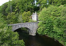 | |||
| Inveravon House, (Former Inveravon Church Of Scotland Manse) And Steading | 57°25′16″N 3°21′46″W | Category B | 8473 | | |||
| Tombae, Former Roman Catholic Presbytery And Garden Wall | 57°18′53″N 3°18′04″W | Category C(S) | 8477 | | |||
| Bridgend Of Glenlivet, Downan Bridge Over River Livet | 57°21′11″N 3°20′27″W | Category C(S) | 8485 | | |||
| Auchbreck, The Old Manse And Steading | 57°20′30″N 3°18′52″W | Category C(S) | 8446 | | |||
| Braes Of Glenlivet, Chapeltown Former School | 57°16′25″N 3°15′33″W | Category C(S) | 8452 | | |||
| Braes Of Glenlivet, Scalan, South Steading With Mill Wheel | 57°15′33″N 3°15′04″W | Category C(S) | 8454 | | |||
| Blacksboat Railway Station Including Goods Shed, Platform And Boundary Walls | 57°26′01″N 3°21′44″W | Category B | 49841 | | |||
| Tombae Farmhouse And Steading | 57°18′46″N 3°17′52″W | Category B | 8479 | | |||
| Bridgend Of Glenlivet, Old Bridge Over River Livet | 57°21′15″N 3°20′10″W | Category B | 8486 | 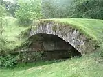 | |||
| Ballindalloch, South Belleheiglash | 57°25′09″N 3°21′31″W | Category C(S) | 8447 | | |||
| Ballindalloch Castle, East Lodge | 57°25′00″N 3°21′34″W | Category B | 8456 | | |||
| Ballindalloch Castle, General James Grant Mausoleum | 57°25′05″N 3°21′58″W | Category B | 8457 | | |||
| Ballindalloch Castle, Gardener's Cottage | 57°25′01″N 3°22′13″W | Category C(S) | 8458 | | |||
| Braes Of Glenlivet, Chapeltown, Roman Catholic Church Of Our Lady Of Perpetual Succour, Chapel House And Burial Ground | 57°16′24″N 3°15′33″W | Category A | 8470 | | |||
| The Glenlivet Distillery, Offices, Warehouses And Visitor Centre | 57°20′36″N 3°20′19″W | Category B | 47431 | | |||
| Braes Of Glenlivet, Scalan, Former Rc Seminary And Cottage | 57°15′35″N 3°15′03″W | Category A | 8453 | 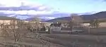 | |||
| Ballindalloch Castle, Gate Lodge And Entrance Arch | 57°24′22″N 3°21′38″W | Category B | 8461 | | |||
| Blairfindy Farmhouse | 57°19′50″N 3°19′29″W | Category B | 8468 | | |||
| Braes Of Glenlivet, Chapeltown, Mont Abbey (Former School And Schoolhouse) | 57°16′25″N 3°15′34″W | Category C(S) | 8471 | | |||
| Inveravon Parish Church, Macpherson - Grant Mausoleum | 57°25′17″N 3°21′42″W | Category B | 8472 | | |||
| Tomnavoulin, Bridge Of Livet Over River Livet | 57°19′26″N 3°18′40″W | Category B | 8481 | | |||
| Ballindalloch Castle, Dovecot | 57°24′49″N 3°22′15″W | Category A | 8450 | .jpg.webp) | |||
| Ballindalloch Castle, Stables, And Stable Cottages | 57°24′55″N 3°22′08″W | Category C(S) | 8455 | | |||
| Ballindalloch, Lady Macpherson - Grant Hall (Former Lady Macpherson - Grant School And Schoolhouse) | 57°24′24″N 3°21′50″W | Category B | 8464 | | |||
| Ballindalloch, Former Railway Bridge Over River Spey | 57°24′50″N 3°23′08″W | Category A | 8466 | .jpg.webp) |
Key
The scheme for classifying buildings in Scotland is:
- Category A: "buildings of national or international importance, either architectural or historic; or fine, little-altered examples of some particular period, style or building type."[1]
- Category B: "buildings of regional or more than local importance; or major examples of some particular period, style or building type, which may have been altered."[1]
- Category C: "buildings of local importance; lesser examples of any period, style, or building type, as originally constructed or moderately altered; and simple traditional buildings which group well with other listed buildings."[1]
In March 2016 there were 47,288 listed buildings in Scotland. Of these, 8% were Category A, and 50% were Category B, with the remaining 42% being Category C.[2]
See also
Notes
- Sometimes known as OSGB36, the grid reference (where provided) is based on the British national grid reference system used by the Ordnance Survey.
• "Guide to National Grid". Ordnance Survey. Retrieved 2007-12-12.
• "Get-a-map". Ordnance Survey. Retrieved 2007-12-17. - Historic Environment Scotland assign a unique alphanumeric identifier to each designated site in Scotland, for listed buildings this always begins with "LB", for example "LB12345".
References
- All entries, addresses and coordinates are based on data from Historic Scotland. This data falls under the Open Government Licence
- "What is Listing?". Historic Environment Scotland. Retrieved 29 May 2018.
- Scotland's Historic Environment Audit 2016 (PDF). Historic Environment Scotland and the Built Environment Forum Scotland. pp. 15–16. Retrieved 29 May 2018.
This article is issued from Wikipedia. The text is licensed under Creative Commons - Attribution - Sharealike. Additional terms may apply for the media files.