List of listed buildings in Inveresk, East Lothian
List
| Name | Location | Date Listed | Grid Ref. [note 1] | Geo-coordinates | Notes | LB Number [note 2] | Image |
|---|---|---|---|---|---|---|---|
| 45 Inveresk Village, Shepherd House With Retaining Walls, Gatepiers And Gates | 55°56′06″N 3°02′34″W | Category B | 10932 |  | |||
| 24 Inveresk Village, Inveresk Lodge With Sundial, Former Outbuilding, Retaining And Terrace Walls | 55°56′06″N 3°02′38″W | Category A | 10938 | 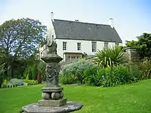 | |||
| Inveresk Village, Crookston Road, Pinkiehill House With Quadrants, Gates And Railings | 55°56′03″N 3°02′26″W | Category B | 10939 | | |||
| Carberry Tower, Game Larder | 55°54′59″N 3°01′14″W | Category B | 10870 | | |||
| Carberry Tower Stables (Elphinstone Wing) | 55°55′00″N 3°01′07″W | Category B | 10874 | | |||
| Chalkieside Farmhouse | 55°54′23″N 3°00′43″W | Category C(S) | 10876 | | |||
| Cowpits, The Old Schoolhouse With Retaining Wall | 55°55′33″N 3°02′32″W | Category B | 10877 | | |||
| 3 Inveresk Village, Inveresk House And Linden House With Garden Walls, Gatepiers And Gateway | 55°56′15″N 3°02′56″W | Category B | 10881 | | |||
| Inveresk Village, Eskhill Lodge With Gatepiers | 55°56′12″N 3°02′43″W | Category B | 10885 | | |||
| Newhailes House, Gardener's Cottage | 55°56′24″N 3°04′55″W | Category C(S) | 10914 | | |||
| Newhailes House, Stables | 55°56′24″N 3°04′53″W | Category A | 10916 | | |||
| Smeaton, Shepherd's Cottage, Stable Court | 55°55′09″N 3°03′20″W | Category C(S) | 10926 | | |||
| 25 Inveresk Village, Rose Court With Garden Walls And Gate | 55°56′10″N 3°02′39″W | Category B | 10930 | | |||
| 14 Inveresk Village, Oak Lodge With Terrace And Retaining Walls And Gatepiers | 55°56′11″N 3°02′46″W | Category B | 10934 | | |||
| 18 Inveresk Village, The Manor House, North Pavilion | 55°56′10″N 3°02′42″W | Category B | 10936 | | |||
| Inveresk Village, 27 And 29 Inveresk Village Road | 55°56′09″N 3°02′38″W | Category B | 10941 | | |||
| Inveresk Village, Pinkiehill Steading And Stalk | 55°56′03″N 3°02′31″W | Category B | 10945 | | |||
| Carberry Tower, Main Gate (Lodge And Archway) With Quadrants, Retaining Walls And Gates | 55°54′37″N 3°00′39″W | Category B | 10871 | | |||
| Carberry Tower, North Lodge Quadrants And Retaining Walls | 55°55′03″N 3°01′37″W | Category C(S) | 10872 | | |||
| Castlesteads Dovecot | 55°55′02″N 3°03′47″W | Category B | 10875 | | |||
| 5 Inveresk Village, Eskgrove House With Dovecot, Gatepiers And Retaining Walls | 55°56′16″N 3°02′51″W | Category B | 10882 | | |||
| 19 Inveresk Village, Catherine Lodge With Stable Block, Retaining Walls And Gatepiers | 55°56′11″N 3°02′38″W | Category A | 10886 | | |||
| Newhailes House, Walled Garden, Walled Flower Garden, Fruit Store, Tea House, Ice House And Terraced Walk | 55°56′41″N 3°04′54″W | Category B | 13038 | | |||
| Smeaton Home Farm, Cottages | 55°54′58″N 3°02′46″W | Category C(S) | 10923 | | |||
| Smeaton House (Known As Smeaton Home Farm) With Garden Walls | 55°54′57″N 3°02′42″W | Category B | 10924 | | |||
| Smeaton, Shepherd's Cottage | 55°55′09″N 3°03′20″W | Category C(S) | 10925 | | |||
| 6 Inveresk Village, Inveresk Research International (Formerly Inveresk Gate) With Gatepiers | 55°56′13″N 3°02′54″W | Category C(S) | 10933 | | |||
| 22 Inveresk Village Halkerston Lodge With Former Stables, Lamp Standards, Terrace And Retaining Walls | 55°56′08″N 3°02′40″W | Category A | 10937 | | |||
| Barbachlaw Farmhouse With Garden Walls | 55°56′06″N 3°01′15″W | Category C(S) | 10865 | | |||
| Carberry Gardens | 55°55′06″N 3°00′55″W | Category C(S) | 10866 | | |||
| Crookston Farmhouse With Retaining Walls | 55°55′35″N 3°01′16″W | Category C(S) | 10878 | | |||
| 23 Inveresk Village, Rosehill With Retaining Walls, Gate And Railings | 55°56′09″N 3°02′38″W | Category B | 10887 | | |||
| Springfield, Glamis Cottage With Railings | 55°54′38″N 3°01′03″W | Category C(S) | 10927 | | |||
| 41 Inveresk Village, Whitehouse And Easter Whitehouse With Retaining Walls, Gatepiers, Gates And Railings | 55°56′07″N 3°02′35″W | Category B | 10931 | | |||
| Inveresk Village, 11 And 12 Crookston Road With Retaining Wall | 55°56′06″N 3°02′31″W | Category C(S) | 10940 | | |||
| Inveresk Village, 35 Inveresk Village Road | 55°56′08″N 3°02′36″W | Category B | 10943 | | |||
| Inveresk Village, 1 And 2 Smeaton Grove With Gateways And Retaining Walls | 55°55′58″N 3°02′33″W | Category B | 10947 | | |||
| Carberry Tower With Terraces And Sundial | 55°54′56″N 3°01′14″W | Category B | 10869 | | |||
| Edenhall Hospital, (Formerly Pinkieburn House), Edenhall Road, Musselburgh, Including Former Stable Block, Sundial And Ornamental Garden Walls And Railings | 55°56′11″N 3°02′12″W | Category C(S) | 50838 | | |||
| Old Craighall, Monkton House With Stable Range, Retaining Walls, Gates And Gatepiers | 55°55′16″N 3°04′03″W | Category A | 10919 | | |||
| 18 Inveresk Village, The Manor House With South Pavilion, Dovecot, Ice House, Retaining Walls, Gates And Gatepiers | 55°56′09″N 3°02′41″W | Category A | 10935 | | |||
| Inveresk Village, Pinkiehill Farmhouse | 55°56′04″N 3°02′33″W | Category B | 10946 | | |||
| Monktonhall Golf Club House And Fountain | 55°55′50″N 3°03′31″W | Category B | 10948 | | |||
| Newhailes House, Dovecot | 55°56′25″N 3°04′54″W | Category B | 10913 | | |||
| Newhailes House, Shell Grotto | 55°56′33″N 3°04′54″W | Category B | 10915 | | |||
| Smeaton Bridge | 55°54′56″N 3°03′01″W | Category B | 10920 | | |||
| Smeaton Home Farm, Stable And Hayloft, Cartshed And Granary, And Former Abattoir | 55°54′50″N 3°02′22″W | Category B | 10922 | | |||
| Inveresk Village, 37 And 39 Inveresk Village Road (Double Dykes), The Laigh House | 55°56′08″N 3°02′36″W | Category B | 10944 | | |||
| Carberry Road, Sweethope Hotel With Retaining Wall And Gateway | 55°55′32″N 3°02′06″W | Category B | 10868 | | |||
| Inveresk Village, Eskgrove Lodge | 55°56′13″N 3°02′46″W | Category C(S) | 10883 | | |||
| Newhailes House With Gatepiers | 55°56′27″N 3°04′45″W | Category A | 10911 |  | |||
| Newhailes House, Earl Of Stair Monument | 55°56′33″N 3°04′51″W | Category B | 10912 | | |||
| Newhailes Road, Newhailes House Gatepiers, Gates, Quadrants, Railings And Policy Walls | 55°56′20″N 3°04′46″W | Category B | 10917 | | |||
| Old Craighall, Monkton Gardens With Sundial And Garden Walls | 55°55′20″N 3°04′02″W | Category B | 10918 | | |||
| Springfield, Pentlands View | 55°54′40″N 3°00′54″W | Category C(S) | 10928 | | |||
| Springfield, Strathmore Cottage With Railings | 55°54′38″N 3°01′04″W | Category C(S) | 10929 | | |||
| Edenhall Hospital, Former Gardener's Cottage | 55°56′09″N 3°02′17″W | Category C(S) | 10879 | | |||
| Inveresk Village, St Michael's Kirk (Church Of Scotland) With Graveyard Walls, Railings And Piers | 55°56′14″N 3°03′04″W | Category A | 10880 | 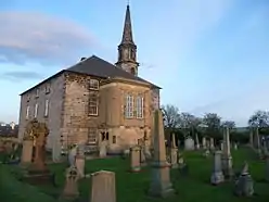 | |||
| Smeaton Gate Lodge, Gatepiers And Screen Walls | 55°54′52″N 3°02′36″W | Category B | 10921 | | |||
| Inveresk Village, 31 And 33 Inveresk Village Road | 55°56′08″N 3°02′37″W | Category B | 10942 | | |||
| Carberry House | 55°55′06″N 3°00′53″W | Category B | 10867 | | |||
| Carberry Tower, South Lodge With Quadrants, Railings, Gates And Gatepiers | 55°54′37″N 3°00′39″W | Category B | 10873 | | |||
| 15 And 17 Inveresk Village, Eskhill With Dovecot, Wellhead, Gatepiers, Railings And Retaining Walls | 55°56′12″N 3°02′44″W | Category B | 10884 | |
Key
The scheme for classifying buildings in Scotland is:
- Category A: "buildings of national or international importance, either architectural or historic; or fine, little-altered examples of some particular period, style or building type."[1]
- Category B: "buildings of regional or more than local importance; or major examples of some particular period, style or building type, which may have been altered."[1]
- Category C: "buildings of local importance; lesser examples of any period, style, or building type, as originally constructed or moderately altered; and simple traditional buildings which group well with other listed buildings."[1]
In March 2016 there were 47,288 listed buildings in Scotland. Of these, 8% were Category A, and 50% were Category B, with the remaining 42% being Category C.[2]
Notes
- Sometimes known as OSGB36, the grid reference (where provided) is based on the British national grid reference system used by the Ordnance Survey.
• "Guide to National Grid". Ordnance Survey. Retrieved 12 December 2007.
• "Get-a-map". Ordnance Survey. Retrieved 17 December 2007. - Historic Environment Scotland assign a unique alphanumeric identifier to each designated site in Scotland, for listed buildings this always begins with "LB", for example "LB12345".
References
- All entries, addresses and coordinates are based on data from Historic Scotland. This data falls under the Open Government Licence
- "What is Listing?". Historic Environment Scotland. Retrieved 29 May 2018.
- Scotland's Historic Environment Audit 2016 (PDF). Historic Environment Scotland and the Built Environment Forum Scotland. pp. 15–16. Retrieved 29 May 2018.
This article is issued from Wikipedia. The text is licensed under Creative Commons - Attribution - Sharealike. Additional terms may apply for the media files.