List of listed buildings in Keith, Moray
List
| Name | Location | Date Listed | Grid Ref. [note 1] | Geo-coordinates | Notes | LB Number [note 2] | Image |
|---|---|---|---|---|---|---|---|
| 124 Land Street, Moorfield | 57°32′28″N 2°57′08″W | Category C(S) | 35639 |  | |||
| 104, 106, 108 Mid Street | 57°32′24″N 2°57′02″W | Category B | 35653 | | |||
| Old Keith, Burial Ground And Site Of Former Parish Church | 57°32′34″N 2°57′30″W | Category B | 35660 | | |||
| 13 Regent Street, St Ronans | 57°32′39″N 2°57′29″W | Category B | 35665 | | |||
| 15 Regent Street, Appin House And Garden Wall Abutting Regent Street And Wellington Terrace | 57°32′39″N 2°57′31″W | Category B | 35666 | | |||
| Seafield Avenue, Holy Trinity Episcopal Church And Enclosing Walls | 57°32′42″N 2°57′10″W | Category B | 35678 | 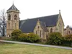 | |||
| 109, 111 Land Street | 57°32′29″N 2°57′06″W | Category C(S) | 35632 | | |||
| 54, 56 Land Street And Garden Walls At South | 57°32′18″N 2°57′10″W | Category B | 35636 | | |||
| 134, 136 Land Street, (Former North Of Scotland Bank) | 57°32′30″N 2°57′08″W | Category B | 35640 | | |||
| 115, 117, Mid Street | 57°32′25″N 2°56′59″W | Category B | 35647 | | |||
| 5 Regent Street | 57°32′38″N 2°57′28″W | Category C(S) | 35664 | | |||
| 33, 35 Regent Street | 57°32′40″N 2°57′36″W | Category C(S) | 35668 | | |||
| 2 Reidhaven Square And Garden Walls | 57°32′17″N 2°56′57″W | Category B | 35674 | | |||
| 46, 48 Duff Street, (Entrance To No 48 Facing Mar Place) And Garden Wall To Mar Place | 57°32′37″N 2°57′52″W | Category C(S) | 35630 | | |||
| Land Street, War Memorial | 57°32′36″N 2°57′06″W | Category B | 35634 | .jpg.webp) | |||
| Crooks Mill | 57°33′01″N 2°59′17″W | Category B | 8701 | | |||
| 49, 51 Mid Street | 57°32′17″N 2°57′01″W | Category B | 35645 | | |||
| 98 Mid Street | 57°32′23″N 2°57′02″W | Category C(S) | 35652 | | |||
| 138, 140 Mid Street, The Institute | 57°32′28″N 2°57′01″W | Category B | 35655 | .jpg.webp) | |||
| 176, 178, 180 Mid Street | 57°32′32″N 2°57′00″W | Category B | 35656 | | |||
| 37, 39 Regent Street | 57°32′41″N 2°57′37″W | Category C(S) | 35669 | | |||
| 14 Chapel Street | 57°32′19″N 2°57′13″W | Category C(S) | 35628 | | |||
| 143, 145 Land Street And 14 Union Street | 57°32′33″N 2°57′06″W | Category C(S) | 35633 | | |||
| 166 Land Street And 16 Union Street | 57°32′33″N 2°57′07″W | Category B | 35643 | | |||
| Old Keith, Bridge Over River Isla | 57°32′37″N 2°57′28″W | Category A | 35661 | 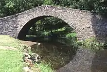 | |||
| 1, 3 Regent Street | 57°32′38″N 2°57′27″W | Category C(S) | 35663 | | |||
| 16, 18 Regent Street | 57°32′39″N 2°57′35″W | Category C(S) | 35671 | | |||
| 7, 9 Chapel Street, Den Mar And Crimond | 57°32′19″N 2°57′07″W | Category C(S) | 35624 | 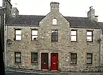 | |||
| 12 Chapel Street | 57°32′19″N 2°57′12″W | Category C(S) | 35627 | | |||
| Church Road, St Rufus Church (Church Of Scotland), Enclosing Walls And Gatepiers | 57°32′37″N 2°57′15″W | Category A | 35629 | 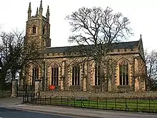 | |||
| 86 Land Street, Cuthill Lea | 57°32′23″N 2°57′09″W | Category B | 35637 | | |||
| Auchindachy Bridge Over River Isla | 57°30′49″N 2°59′28″W | Category B | 8700 | | |||
| 88, 90, 92 Land Street, Chapel House | 57°32′24″N 2°57′09″W | Category C(S) | 35638 | | |||
| 168, 170 Land Street | 57°32′34″N 2°57′07″W | Category C(S) | 35644 | | |||
| 161, 163 Mid Street, Clydesdale Bank | 57°32′30″N 2°56′58″W | Category C(S) | 35648 | | |||
| 2 Nelson Terrace | 57°32′38″N 2°57′38″W | Category B | 35659 | | |||
| 47, 49 Regent Street, 2 And 2A Station Road, Regent House | 57°32′42″N 2°57′39″W | Category B | 35670 | | |||
| 28, 30 Regent Street And Return Elevation To Regent Square, Fife Arms Hotel | 57°32′40″N 2°57′38″W | Category B | 35672 | 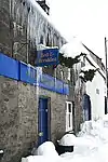 | |||
| 36 Regent Street And 4, 5 Regent Square, Grampian Hotel (Formerly Gordon Arms Hotel) | 57°32′41″N 2°57′43″W | Category C(S) | 35673 | | |||
| 17 Reidhaven Square | 57°32′19″N 2°57′05″W | Category B | 35676 | | |||
| 22, 23 Reidhaven Square, The Crown Inn And 53, 55 Mid Street | 57°32′19″N 2°57′00″W | Category C(S) | 35677 | | |||
| Seafield Avenue, Strathisla Distillery | 57°32′48″N 2°57′18″W | Category A | 35679 | 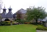 | |||
| Chapel Street, Roman Catholic Church Of St Thomas And Presbytery | 57°32′19″N 2°57′16″W | Category A | 35623 | 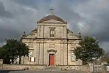 | |||
| 140 Land Street | 57°32′30″N 2°57′08″W | Category C(S) | 35641 | | |||
| 162, 164 Land Street | 57°32′33″N 2°57′07″W | Category C(S) | 35642 | | |||
| 56-66 (Even Nos) Mid Street And 20, 21 Reidhaven Square | 57°32′19″N 2°57′02″W | Category B | 35650 | | |||
| 43 Moss Street | 57°32′17″N 2°56′55″W | Category B | 35657 | | |||
| 45 Moss Street | 57°32′17″N 2°56′55″W | Category B | 35658 | | |||
| 29, 31 Regent Street | 57°32′40″N 2°57′35″W | Category C(S) | 35667 | | |||
| 8 Reidhaven Square And 50-54 (Even Nos) Mid Street | 57°32′17″N 2°57′03″W | Category B | 35675 | | |||
| 13, 15 Chapel Street | 57°32′19″N 2°57′10″W | Category C(S) | 35626 | | |||
| Crooksmill Bridge Over Forgie Burn | 57°33′02″N 2°59′17″W | Category C(S) | 8702 | | |||
| 86 Mid Street, Seafield Arms Hotel | 57°32′22″N 2°57′02″W | Category B | 35651 | | |||
| 130, 132 Mid Street, The Post Office | 57°32′27″N 2°57′01″W | Category B | 35654 | | |||
| 2 Regent Square And Garden Walls | 57°32′39″N 2°57′41″W | Category B | 35662 | | |||
| Union Bridge Over River Isla | 57°32′37″N 2°57′25″W | Category C(S) | 35682 | 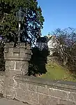 | |||
| 42 Land Street, Former Steading At Rear And Garden Wall | 57°32′16″N 2°57′10″W | Category C(S) | 35635 | | |||
| Newmill, Mill Of Newmill | 57°33′22″N 2°56′23″W | Category C(S) | 8704 | | |||
| Newmill, War Memorial Clock Tower | 57°33′33″N 2°56′44″W | Category C(S) | 8705 | 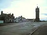 | |||
| 105, 107 Mid Street | 57°32′24″N 2°56′59″W | Category B | 35646 | | |||
| Mid Street, North Church Of Scotland | 57°32′34″N 2°56′57″W | Category B | 35649 | .jpg.webp) | |||
| Station Road, Linn Bridge Over River Isla | 57°32′49″N 2°57′23″W | Category B | 35680 | | |||
| 11 Chapel Street, Cuthill House | 57°32′19″N 2°57′08″W | Category B | 35625 | 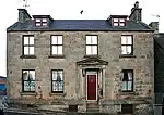 | |||
| Edintore House | 57°30′01″N 2°57′27″W | Category B | 8703 | |
Key
The scheme for classifying buildings in Scotland is:
- Category A: "buildings of national or international importance, either architectural or historic; or fine, little-altered examples of some particular period, style or building type."[1]
- Category B: "buildings of regional or more than local importance; or major examples of some particular period, style or building type, which may have been altered."[1]
- Category C: "buildings of local importance; lesser examples of any period, style, or building type, as originally constructed or moderately altered; and simple traditional buildings which group well with other listed buildings."[1]
In March 2016 there were 47,288 listed buildings in Scotland. Of these, 8% were Category A, and 50% were Category B, with the remaining 42% being Category C.[2]
See also
Notes
- Sometimes known as OSGB36, the grid reference (where provided) is based on the British national grid reference system used by the Ordnance Survey.
• "Guide to National Grid". Ordnance Survey. Retrieved 12 December 2007.
• "Get-a-map". Ordnance Survey. Retrieved 17 December 2007. - Historic Environment Scotland assign a unique alphanumeric identifier to each designated site in Scotland, for listed buildings this always begins with "LB", for example "LB12345".
References
- All entries, addresses and coordinates are based on data from Historic Scotland. This data falls under the Open Government Licence
- "What is Listing?". Historic Environment Scotland. Retrieved 29 May 2018.
- Scotland's Historic Environment Audit 2016 (PDF). Historic Environment Scotland and the Built Environment Forum Scotland. pp. 15–16. Retrieved 29 May 2018.
This article is issued from Wikipedia. The text is licensed under Creative Commons - Attribution - Sharealike. Additional terms may apply for the media files.