List of listed buildings in Kilmallie, Highland
Key
The scheme for classifying buildings in Scotland is:
- Category A: "buildings of national or international importance, either architectural or historic; or fine, little-altered examples of some particular period, style or building type."[1]
- Category B: "buildings of regional or more than local importance; or major examples of some particular period, style or building type, which may have been altered."[1]
- Category C: "buildings of local importance; lesser examples of any period, style, or building type, as originally constructed or moderately altered; and simple traditional buildings which group well with other listed buildings."[1]
In March 2016 there were 47,288 listed buildings in Scotland. Of these, 8% were Category A, and 50% were Category B, with the remaining 42% being Category C.[2]
List
| Name | Location | Date Listed | Grid Ref. [note 1] | Geo-coordinates | Notes | LB Number [note 2] | Image |
|---|---|---|---|---|---|---|---|
| Fassfern House, Steading Ranges And Rear Walled Garden | 56°51′28″N 5°14′52″W | Category B | 7069 |  | |||
| Kinlocheil, Snowburn Steading | 56°51′37″N 5°19′36″W | Category C(S) | 7074 | | |||
| Callert Barn | 56°41′47″N 5°07′04″W | Category B | 7092 | | |||
| Kiachnish Bridge (Old) Over River Kiachnish Near Coruanan | 56°46′23″N 5°09′53″W | Category B | 7071 | | |||
| Loy Bridge Over River Loy | 56°53′27″N 5°02′29″W | Category B | 7075 | | |||
| Onich, Walled Garden Cuilcheanna House | 56°42′18″N 5°14′09″W | Category B | 7076 | | |||
| Caledonian Canal, Corpach, Former Storehouse | 56°50′32″N 5°07′23″W | Category B | 7083 | | |||
| Caledonian Canal, Moy Swing Bridge Keeper's Cottage And Garden Walls | 56°53′55″N 5°01′08″W | Category B | 7088 | | |||
| Caledonian Canal, Torcastle Aqueduct Over The Allt Sheangain | 56°51′58″N 5°03′59″W | Category A | 7090 | .jpg.webp) | |||
| Achnacarry. Chia-Aig Bridge. Over Abhainn Chia-Aig | 56°57′17″N 5°00′05″W | Category B | 7100 | | |||
| North Ballachulish, Dunbeg House Including Gatepiers And Boundary Walls | 56°41′34″N 5°10′22″W | Category B | 50833 | | |||
| Onich, Old Manse Garden Wall And Gatepiers. (Former North Ballachulish Church Of Scotland Manse) | 56°42′11″N 5°13′01″W | Category C(S) | 7078 | | |||
| Corpach, Kilmallie Parish Church Of Scotland Enclosing Wall With Gate Piers And Cameron Memorial | 56°50′41″N 5°07′53″W | Category C(S) | 7094 | | |||
| Fassfern Bridge Over The An T-Suileag Burn | 56°51′35″N 5°14′51″W | Category C(S) | 7070 | | |||
| Caledonian Canal, Banavie, Neptune's Staircase, Lock Cottage, (Lock Keepers' House) | 56°50′48″N 5°05′38″W | Category B | 7081 | | |||
| Caledonian Canal, Aqueduct Over The River Loy | 56°53′25″N 5°02′23″W | Category A | 7085 | .jpg.webp) | |||
| Achnacarry, St Cian's Church Of Scotland | 56°56′28″N 4°59′30″W | Category B | 7099 | | |||
| Corpach, Obelisk | 56°50′39″N 5°07′56″W | Category B | 7066 | | |||
| Corpach, Kilmallie House | 56°50′36″N 5°07′32″W | Category B | 7067 | | |||
| Caledonian Canal Banavie, Neptune's Staircase, Former Smithy And Former Stables | 56°50′46″N 5°05′37″W | Category C(S) | 7080 | | |||
| Caledonian Canal, Corpach, 1, 2, Ardbeg (Lock Keepers' Cottages) | 56°50′33″N 5°07′12″W | Category B | 7084 | | |||
| Achnacarry House Stables | 56°56′48″N 5°00′10″W | Category C(S) | 7097 | | |||
| Kinlochiel Mission Church | 56°51′28″N 5°18′34″W | Category C(S) | 7073 | | |||
| Onich, Nether Lochaber Episcopal Church Of St Bride And Burial Ground | 56°42′01″N 5°11′00″W | Category C(S) | 7077 | | |||
| Caledonian Canal, Banavie, Neptune's Staircase, Studio Salix | 56°50′52″N 5°05′33″W | Category B | 7082 | | |||
| Caledonian Canal, Bank Cottage By Torcastle | 56°52′16″N 5°03′37″W | Category B | 7086 | | |||
| By Callert, Cameron Mausoleum | 56°41′25″N 5°09′03″W | Category B | 7093 | | |||
| Corpach, Icehouse | 56°50′30″N 5°08′18″W | Category C(S) | 7068 | | |||
| Callert House | 56°41′46″N 5°07′07″W | Category A | 7091 | 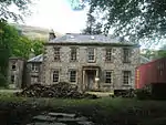 | |||
| Kinlocheil, Druim Na Saille Bridge Over Fionn Lighe River | 56°51′41″N 5°20′51″W | Category B | 7072 | | |||
| Caledonian Canal, Banavie, Swing Railway Bridge Over Caledonian Canal | 56°50′39″N 5°05′50″W | Category B | 7079 | | |||
| Caledonian Canal, Mount Alexander Aqueduct Over Allt Mor | 56°51′08″N 5°04′53″W | Category B | 7087 | | |||
| Caledonian Canal, Sluice By Carn Phail | 56°53′08″N 5°02′24″W | Category A | 7089 | 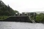 | |||
| Corpach, Old Kilmallie Church And Burial Ground | 56°50′40″N 5°07′57″W | Category C(S) | 7095 | | |||
| Achnacarry House | 56°56′49″N 4°59′57″W | Category B | 7096 | | |||
| Achnacarry, Old Post Office | 56°56′41″N 5°00′02″W | Category C(S) | 7098 | |
See also
Notes
- Sometimes known as OSGB36, the grid reference (where provided) is based on the British national grid reference system used by the Ordnance Survey.
• "Guide to National Grid". Ordnance Survey. Retrieved 2007-12-12.
• "Get-a-map". Ordnance Survey. Retrieved 2007-12-17. - Historic Environment Scotland assign a unique alphanumeric identifier to each designated site in Scotland, for listed buildings this always begins with "LB", for example "LB12345".
General references
- All entries, addresses and coordinates are based on data from Historic Scotland. This data falls under the Open Government Licence.
Citations
- "What is Listing?". Historic Environment Scotland. Retrieved 29 May 2018.
- Scotland's Historic Environment Audit 2016 (PDF). Historic Environment Scotland and the Built Environment Forum Scotland. pp. 15–16. Retrieved 29 May 2018.
This article is issued from Wikipedia. The text is licensed under Creative Commons - Attribution - Sharealike. Additional terms may apply for the media files.