List of listed buildings in Motherwell And Wishaw, North Lanarkshire
This is a list of listed buildings in the parish of Motherwell And Wishaw in North Lanarkshire, Scotland.
List
| Name | Location | Date Listed | Grid Ref. [note 1] | Geo-coordinates | Notes | LB Number [note 2] | Image |
|---|---|---|---|---|---|---|---|
| Cambusnethan, Kirk Road, Cambusnethan Old Parish Church (Church Of Scotland) Including Church Hall, Vestry And Session House, War Memorial, Boundary Wall, Gatepiers, Gates And Railings | 55°46′36″N 3°54′16″W | Category C(S) | 38235 | 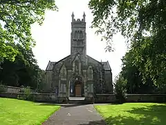 | |||
| Motherwell, Manse Road, Old Dalzell Manse Including Coach House | 55°46′20″N 3°59′13″W | Category B | 38241 |  | |||
| Motherwell, South Calder Water, Jerviston Railway Viaduct | 55°48′16″N 3°59′36″W | Category B | 38242 | | |||
| Motherwell, 83 Camp Road, Camp Cottage (Also Known As Archibald's Temple) | 55°46′45″N 3°59′52″W | Category C(S) | 38245 | | |||
| Wishaw, 9-35 (Odd Nos) Banchory Road, The Coach House | 55°47′09″N 3°55′03″W | Category B | 47346 | | |||
| Wishaw, West Thornlie Street, Thornlie Parish Church, Church Of Scotland Former United Free Church Including Hall Gates And Boundary Walls | 55°46′19″N 3°55′21″W | Category C(S) | 47505 | 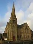 | |||
| Wishaw, 2 Belhaven Road | 55°46′35″N 3°55′41″W | Category B | 47936 | | |||
| Wishaw, 47 Clelland Road, Including Boundary Wall | 55°46′39″N 3°55′50″W | Category B | 47939 | | |||
| Wishaw, 161 Kirk Road Including Boundary Wall | 55°46′37″N 3°54′49″W | Category C(S) | 47946 | | |||
| Wishaw, 2 Kirk Road | 55°46′24″N 3°55′09″W | Category B | 47949 | | |||
| Wishaw, 177-191(Odd Nos) Main Street And 2-20 (Even) Belhaven Terrace, Cylde Chambers | 55°46′32″N 3°55′26″W | Category C(S) | 47953 | | |||
| Wishaw, Stewarton Street, Stewarton Street Park, Marker Post | 55°46′03″N 3°54′32″W | Category C(S) | 47961 | | |||
| Wishaw, 11 Walter Street | 55°46′35″N 3°54′19″W | Category C(S) | 47964 | | |||
| Motherwell, 33 And 35 Hamilton Road, Motherwell Public Library | 55°47′21″N 3°59′39″W | Category B | 48307 | 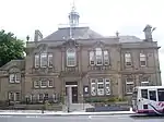 | |||
| Wishaw, 59-69 (Odd Nos) Kirk Road, Mecca Bingo (Formerly Green's Playhouse) | 55°46′28″N 3°55′06″W | Category C(S) | 49605 | | |||
| Motherwell,Dalzell Park, Gazebo | 55°46′17″N 3°59′08″W | Category C(S) | 38240 | | |||
| Motherwell, 78 Muir Street, Gospel Literature Outreach Centre (Formerly Dalziel Free Church) Including Church Hall, Manse And Boundary Wall | 55°47′31″N 3°59′36″W | Category B | 38244 | 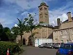 | |||
| Wishaw, 57-59 (Odd Nos) Main Street | 55°46′27″N 3°55′16″W | Category C(S) | 47951 | | |||
| Wishaw, 231 - 257 (Odd Nos) Main Street | 55°46′33″N 3°55′30″W | Category C(S) | 47954 | | |||
| Wishaw, 206-216 (Even Numbers) Main Street | 55°46′32″N 3°55′23″W | Category C(S) | 47958 | | |||
| Wishaw, Young Street, St Ignatius Roman Catholic Church Including Boundary Wall And Gate Pier | 55°46′28″N 3°54′55″W | Category A | 47975 | | |||
| Motherwell, Burnside Street, Burngrange Lodge Including Boundary Wall And Gate Piers | 55°46′38″N 3°58′15″W | Category C(S) | 48300 | | |||
| Motherwell, 114 Hamilton Road, The Moorings House Hotel | 55°47′19″N 3°59′53″W | Category C(S) | 48308 | | |||
| Motherwell, 225 Manse Road, North Lodge Including Gatepiers, Gate And Railings | 55°46′35″N 3°59′03″W | Category C(S) | 48310 | 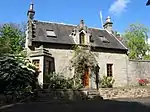 | |||
| Motherwell, 344 Muir Street (Formerly St Andrews Parish Church) | 55°47′40″N 3°59′47″W | Category C(S) | 48313 | | |||
| Motherwell, 15 Orchard Street, Crosshill Manse Including Boundary Wall And Gate Piers | 55°47′23″N 3°59′50″W | Category B | 48314 | | |||
| Motherwell, Windmillhill Street, South Dalziel Parish Church (Church Of Scotland) Including Vestry, Session House, Church Hall And Boundary Wall | 55°47′02″N 3°58′48″W | Category B | 38237 | 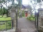 | |||
| Wishaw, Glen Road, Belhaven Estate, The Coach House | 55°47′10″N 3°56′10″W | Category C(S) | 47942 | | |||
| Wishaw, Kenilworth Avenue, Reformed Presbyterian Church Including Boundary Wall And Railings | 55°46′30″N 3°55′14″W | Category C(S) | 47944 | | |||
| Wishaw, 9 Kenilworth Avenue, Reformed Presbertyrian Church Manse | 55°46′30″N 3°55′16″W | Category C(S) | 47945 | | |||
| Wishaw, 155-175 (Odd Nos) Main Street And 1-11 (Odd Nos) Belhaven Terrace, Richmond Place | 55°46′31″N 3°55′24″W | Category B | 47952 | | |||
| Wishaw, 40-50 (Even Nos) Main St | 55°46′27″N 3°55′12″W | Category C(S) | 47957 | | |||
| Wishaw, 5 Stewarton Street | 55°46′24″N 3°55′08″W | Category C(S) | 47962 | | |||
| Cambusnethan, Kirk Road, Cambusnethan North Parish Church Including Church Hall And Boundary Wall (Church Of Scotland Formerly Free Church) | 55°46′38″N 3°54′09″W | Category C(S) | 48015 | | |||
| Motherwell, Avon Street, Holy Trinity Episcopal Church | 55°47′18″N 3°59′42″W | Category C(S) | 48296 | | |||
| Motherwell, Dalzell Park, St Patrick's Well | 55°46′17″N 3°59′09″W | Category C(S) | 48303 | 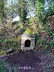 | |||
| Motherwell, Windmillhill Street, Drinking Fountain | 55°47′10″N 3°59′05″W | Category C(S) | 48316 | | |||
| Motherwell, 2-44 (Even Nos) Scott Street And 64 Dalziel Street (Former Dalziel Co-Operative Society Building) | 55°47′32″N 3°59′12″W | Category B | 38246 | | |||
| Wishaw, Ballater Crescent, Marker Post | 55°47′02″N 3°54′58″W | Category C(S) | 47935 | | |||
| Wishaw, 19-21 Campbell Street | 55°46′30″N 3°54′52″W | Category C(S) | 47937 | | |||
| Wishaw, 2 Coltness Road And 279 Kirk Road | 55°46′40″N 3°54′26″W | Category C(S) | 47940 | | |||
| Wishaw, 32-38 (Even Nos) Main Street | 55°46′26″N 3°55′12″W | Category C(S) | 47956 | | |||
| Wishaw, 147 Stewarton Street, Coltness Masonic Lodge | 55°46′17″N 3°54′54″W | Category C(S) | 47963 | | |||
| Motherwell, 301 Brandon Street, Motherwell Ymca | 55°47′13″N 3°59′07″W | Category B | 48299 | | |||
| Motherwell, 23-27 Hope Street, Motherwell Masonic Halls | 55°47′33″N 3°59′37″W | Category C(S) | 48309 | | |||
| Motherwell, Merry Street, Dalziel Parish Church ( Church Of Scotland) Including Church Hall And Boundary Wall | 55°47′28″N 3°59′32″W | Category B | 48311 | | |||
| Wishaw, 6 West Thornlie St, Thornile Manse | 55°46′20″N 3°55′20″W | Category B | 45577 | | |||
| Wishaw, Main Street, Wishaw Old Parish Church (Church Of Scotland) | 55°46′31″N 3°55′18″W | Category B | 47504 | | |||
| Wishaw 3-19 (Odd Nos) Main Street And 2 Caledonian Road | 55°46′25″N 3°55′12″W | Category C(S) | 47950 | | |||
| Calder Bridge, Wishaw Low Road And Glen Road, Wishaw | 55°47′08″N 3°55′40″W | Category C(S) | 48014 | 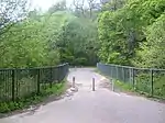 | |||
| Motherwell, Windmillhill Street, Motherwell Baptist Church Including Church Hall | 55°47′10″N 3°59′03″W | Category C(S) | 48317 | | |||
| 141-145 (Odd Nos) Main Street, Ymca Building | 55°46′30″N 3°55′23″W | Category C(S) | 49232 | | |||
| Cambusnethan, Kirk Road, Former Parish Church Including Boundary Wall And Cemetery (Church Of Scotland) | 55°46′37″N 3°54′13″W | Category B | 38236 | | |||
| Motherwell, Dalzell Park, Hamilton Of Dalzell Mausoleum And St Patrick's Graveyard Including Boundary Walls | 55°46′16″N 3°59′10″W | Category B | 38239 | 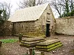 | |||
| Motherwell, Mill Road, The Old Mill Hotel (Formerly Motherwell Mill) | 55°47′56″N 3°59′06″W | Category C(S) | 38243 | | |||
| Wishaw, Glasgow Road, St Patricks Roman Catholic Church And Presbytery Including Stone Steps And Concourse | 55°46′46″N 3°57′22″W | Category C(S) | 47941 | 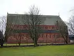 | |||
| Wishaw, 325 North Dryburgh Road, Bellside Lodge Including Boundary Wall And Railings | 55°47′39″N 3°54′49″W | Category C(S) | 47960 | | |||
| Motherwell, Crawford Street, Dalziel High School | 55°47′13″N 4°00′00″W | Category C(S) | 48302 | | |||
| Motherwell, Park Street, Dalzell Steelworks: Offices And Workshops Fronting Park Street | 55°47′19″N 3°58′58″W | Category B | 48315 | | |||
| Wishaw, 57 Kirk Road, Former Cinema | 55°46′27″N 3°55′08″W | Category C(S) | 49604 | | |||
| Wishaw, Belhaven Terrace, St Andrews Episcopal Church Including Boundary Wall | 55°46′30″N 3°55′25″W | Category C(S) | 45605 | | |||
| Motherwell, Dalzell House Including Wellhead, Coach House, Stables And Terraced Garden | 55°46′20″N 3°58′41″W | Category A | 38238 | | |||
| Wishaw, East Academy Street, Chalmers Parish Church Including Church Hall And Boundary Wall (Church Of Scotland Formerly United Presbertyrian) | 55°46′20″N 3°55′08″W | Category C(S) | 47503 | 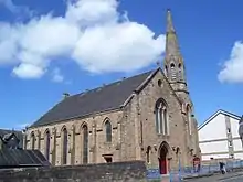 | |||
| Wishaw, 307 Kirk Road, Vine Cottage | 55°46′39″N 3°54′18″W | Category C(S) | 47948 | | |||
| Wishaw, 26-30 (Even Nos) Main Street | 55°46′26″N 3°55′11″W | Category C(S) | 47955 | | |||
| Wishaw, Main Street And Kenilworth Avenue Former Coltness Gatehouse | 55°46′28″N 3°55′15″W | Category B | 47959 | | |||
| Motherwell, Brandon Street, Evangelical Union Congregational Church Including Boundary Wall And Gatepiers | 55°47′16″N 3°59′11″W | Category C(S) | 48297 | | |||
| Motherwell, Coursington Road, Our Lady Of Good Aid, Roman Catholic Cathedral Including Presbytery, Boundary Wall, Gatepiers And Railings | 55°47′29″N 3°59′14″W | Category B | 48301 | | |||
| Motherwell, Dalzell Park, The Sow Bridge Including Feeder Pond, Rill And Cascade | 55°46′21″N 3°58′56″W | Category C(S) | 48304 | 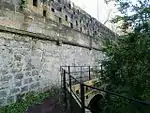 | |||
| Motherwell, Hamilton Road, Former Motherwell Town Hall | 55°47′23″N 3°59′40″W | Category C(S) | 48305 | 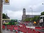 | |||
| Motherwell 1 Hamilton Road And 1, 3-15 (Odd Nos) Muir Street | 55°47′26″N 3°59′36″W | Category C(S) | 48306 | | |||
| Motherwell, 31-37 (Odd Nos) Merry Street, The Railway Tavern | 55°47′28″N 3°59′32″W | Category C(S) | 48312 | | |||
| Wishaw, 43-45 Clelland Road Including Boundary Wall | 55°46′38″N 3°55′50″W | Category C(S) | 47938 | | |||
| Wishaw, 9 Glencairn Avenue, Craigneuk | 55°46′45″N 3°57′15″W | Category C(S) | 47943 | | |||
| Wishaw, 177 Kirk Road Including Boundary Wall | 55°46′38″N 3°54′43″W | Category C(S) | 47947 | | |||
| Wishaw,Waterloo Dimsdale Road, Pather Farmhouse | 55°45′45″N 3°54′38″W | Category B | 47974 | | |||
| Motherwell, 273-287(Odd), 291 And 293 Brandon Street | 55°47′13″N 3°59′09″W | Category C(S) | 48298 | |
Key
The scheme for classifying buildings in Scotland is:
- Category A: "buildings of national or international importance, either architectural or historic; or fine, little-altered examples of some particular period, style or building type."[1]
- Category B: "buildings of regional or more than local importance; or major examples of some particular period, style or building type, which may have been altered."[1]
- Category C: "buildings of local importance; lesser examples of any period, style, or building type, as originally constructed or moderately altered; and simple traditional buildings which group well with other listed buildings."[1]
In March 2016 there were 47,288 listed buildings in Scotland. Of these, 8% were Category A, and 50% were Category B, with the remaining 42% being Category C.[2]
Notes
- Sometimes known as OSGB36, the grid reference (where provided) is based on the British national grid reference system used by the Ordnance Survey.
• "Guide to National Grid". Ordnance Survey. Retrieved 2007-12-12.
• "Get-a-map". Ordnance Survey. Retrieved 2007-12-17. - Historic Environment Scotland assign a unique alphanumeric identifier to each designated site in Scotland, for listed buildings this always begins with "LB", for example "LB12345".
References
- All entries, addresses and coordinates are based on data from Historic Scotland. This data falls under the Open Government Licence
- "What is Listing?". Historic Environment Scotland. Retrieved 29 May 2018.
- Scotland's Historic Environment Audit 2016 (PDF). Historic Environment Scotland and the Built Environment Forum Scotland. pp. 15–16. Retrieved 29 May 2018.
This article is issued from Wikipedia. The text is licensed under Creative Commons - Attribution - Sharealike. Additional terms may apply for the media files.