List of listed buildings in Musselburgh, East Lothian
List
| Name | Location | Date Listed | Grid Ref. [note 1] | Geo-coordinates | Notes | LB Number [note 2] | Image |
|---|---|---|---|---|---|---|---|
| 110 And 112 North High Street | 55°56′37″N 3°03′36″W | Category C(S) | 38374 |  | |||
| Station Road Links Coachworks | 55°56′23″N 3°03′31″W | Category B | 38385 | | |||
| 1-53 West Holmes Gardens, Odd Numbers | 55°56′28″N 3°03′34″W | Category B | 38390 | | |||
| 57-67 Odd Numbers And 68-104 Even Numbers West Holmes Gardens | 55°56′30″N 3°03′35″W | Category C(S) | 38391 | | |||
| 2-14 West Holmes Gardens, Even Numbers | 55°56′28″N 3°03′33″W | Category B | 38392 | | |||
| 22 And 24 West Holmes Gardens | 55°56′29″N 3°03′34″W | Category B | 38394 | | |||
| 26-64 West Holmes Gardens Even Numbers | 55°56′30″N 3°03′36″W | Category B | 38395 | | |||
| 1-8 Windsor Gardens, Consecutive Numbers | 55°56′42″N 3°02′06″W | Category B | 38397 | | |||
| 24 Hercus Loan | 55°56′32″N 3°03′30″W | Category C(S) | 38290 | | |||
| 31 And 33 High Street | 55°56′37″N 3°02′51″W | Category B | 38299 | | |||
| 35, 37 And 39 High Street | 55°56′37″N 3°02′52″W | Category C(S) | 38300 | | |||
| 58 And 60 High Street Rumours Corner Of Newbigging | 55°56′34″N 3°02′53″W | Category C(S) | 38323 | | |||
| Linkfield Road Corner Of Millhill Loretto School Loretto Villa | 55°56′43″N 3°02′38″W | Category B | 38334 | | |||
| Linkfield Road Loretto School Mound | 55°56′41″N 3°02′38″W | Category C(S) | 38336 | | |||
| Linkfield Road, 1-13 Albert Terrace (Consecutive Numbers) | 55°56′43″N 3°02′08″W | Category B | 38344 | | |||
| Mall Avenue Moir Statue | 55°56′31″N 3°03′16″W | Category B | 38346 | | |||
| North High Street North Esk Lodge Corner Of Eskside West | 55°56′40″N 3°03′10″W | Category B | 38366 | | |||
| 4 Balcarres Road Formerly Bruntsfield Links Golfing Society | 55°56′45″N 3°02′46″W | Category B | 38248 | | |||
| 11, 13 And 15 Bridge Street | 55°56′34″N 3°03′20″W | Category C(S) | 38251 | | |||
| 23 Bridge Street | 55°56′35″N 3°03′21″W | Category C(S) | 38253 | | |||
| 26 Bridge Street | 55°56′37″N 3°03′29″W | Category B | 38263 | | |||
| 3 And 5 Campie Lane | 55°56′35″N 3°03′42″W | Category C(S) | 38265 | | |||
| 32 And 33 Eskside West And 1 Hercus Loan | 55°56′31″N 3°03′24″W | Category C(S) | 38285 | | |||
| 79-81 North High Street, Volunteer Arms (Staggs) | 55°56′39″N 3°03′26″W | Category C(S) | 51111 | | |||
| Windsor Gardens, St Anne's Convent | 55°56′45″N 3°02′30″W | Category B | 38399 | | |||
| 34 And 36 Ravensheugh Road | 55°56′45″N 3°01′27″W | Category B | 38381 | | |||
| Stoneyhill | 55°56′20″N 3°03′55″W | Category B | 38387 | | |||
| 16-20 West Holmes Gardens, Even Numbers | 55°56′30″N 3°03′33″W | Category B | 38393 | | |||
| 9-15 Windsor Gardens, Consecutive Numbers | 55°56′42″N 3°02′11″W | Category B | 38398 | | |||
| 23-29 (Odd Nos) High Street | 55°56′37″N 3°02′50″W | Category B | 38297 | | |||
| 41 High Street Post Office | 55°56′37″N 3°02′52″W | Category B | 38301 | | |||
| 65-75 High Street Odd Numbers | 55°56′35″N 3°02′57″W | Category C(S) | 38310 | | |||
| 129-135 High Street Odd Numbers | 55°56′33″N 3°03′05″W | Category C(S) | 38312 | | |||
| High Street Pinkie House Walled Garden | 55°56′34″N 3°02′35″W | Category B | 38317 | | |||
| 2, 4 High Street | 55°56′36″N 3°02′44″W | Category C(S) | 38320 | | |||
| 67 Millhill Montague House | 55°56′40″N 3°02′57″W | Category B | 38349 | | |||
| 54 Millhill | 55°56′38″N 3°02′57″W | Category C(S) | 38355 | | |||
| 109 Newbigging | 55°56′22″N 3°02′53″W | Category B | 38360 | | |||
| 43 And 45 Bridge Street | 55°56′36″N 3°03′24″W | Category C(S) | 38254 | | |||
| 4 And 6 Bridge Street/26 Eskside West | 55°56′33″N 3°03′20″W | Category B | 38257 | | |||
| Bridge Street, North Esk Church (C Of S) | 55°56′36″N 3°03′27″W | Category B | 38260 | | |||
| 2 Bush Terrace Corner Of New Street | 55°56′42″N 3°03′49″W | Category C(S) | 38264 | | |||
| 20-32 Campie Road Even Numbers And 66 West Holmes Gardens | 55°56′32″N 3°03′41″W | Category B | 38266 | | |||
| 35 And 37 Dalrymple Loan | 55°56′26″N 3°03′10″W | Category C(S) | 38271 | | |||
| 8 Eskside West Eskside House Including Garden Wall And Gazebo | 55°56′37″N 3°03′12″W | Category B | 38276 | | |||
| 29 Eskside West | 55°56′32″N 3°03′22″W | Category C(S) | 38282 | | |||
| 31 Eskside West | 55°56′32″N 3°03′23″W | Category C(S) | 38284 | | |||
| 57 And 58 Eskside West | 55°56′27″N 3°03′32″W | Category B | 38286 | | |||
| 21 North High Street Musselburgh And Fisherrow Co-Operative Society Store | 55°56′39″N 3°03′16″W | Category B | 38367 | | |||
| 167 North High Street | 55°56′39″N 3°03′37″W | Category C(S) | 38369 | | |||
| 176 And 178 North High Street | 55°56′38″N 3°03′49″W | Category C(S) | 38376 | | |||
| 30 And 32 Ravensheugh Road | 55°56′44″N 3°01′28″W | Category C(S) | 38380 | | |||
| 40 Ravensheugh Road | 55°56′45″N 3°01′27″W | Category C(S) | 38382 | | |||
| 1 Shorthope Street | 55°56′34″N 3°03′03″W | Category C(S) | 38383 | | |||
| 1 And 2 Grove Street And 67 Pinkie Road | 55°56′26″N 3°02′35″W | Category B | 38288 | | |||
| 3 And 4 Grove Street | 55°56′25″N 3°02′34″W | Category B | 38289 | | |||
| 1 And 3 High Street | 55°56′38″N 3°02′46″W | Category B | 38292 | | |||
| 13 High Street | 55°56′37″N 3°02′47″W | Category B | 38295 | | |||
| 123 High Street On Corner Of Shorthope Street | 55°56′34″N 3°03′04″W | Category B | 38311 | | |||
| High Street David Wright Drinking Fountain | 55°56′32″N 3°03′14″W | Category B | 38313 | | |||
| 1, 3A And 3B Dambrae, Corner Of High Street | 55°56′34″N 3°02′58″W | Category B | 38332 | | |||
| 14 A B C And D Linkfield Road | 55°56′43″N 3°02′29″W | Category B | 38340 | | |||
| 17 And 18 Linkfield Road | 55°56′43″N 3°02′27″W | Category B | 38342 | | |||
| 19 Linkfield Road | 55°56′43″N 3°02′26″W | Category B | 38343 | | |||
| 33-39 Millhill Trafalgar Lodge (Odd Numbers) | 55°56′44″N 3°02′52″W | Category B | 38348 | | |||
| 71 And 73 Millhill | 55°56′39″N 3°02′58″W | Category B | 38351 | | |||
| 77 Millhill Millhill House | 55°56′39″N 3°02′59″W | Category C(S) | 38352 | | |||
| 50 And 52 Millhill | 55°56′38″N 3°02′57″W | Category C(S) | 38354 | | |||
| 17 And 19 Bridge Street | 55°56′35″N 3°03′21″W | Category C(S) | 38252 | | |||
| Bridge Street St Andrew's Church Hall, | 55°56′37″N 3°03′24″W | Category C(S) | 38256 | | |||
| 22 Bridge Street | 55°56′36″N 3°03′28″W | Category B | 38262 | | |||
| 14 Eskside West | 55°56′35″N 3°03′16″W | Category C(S) | 38279 | | |||
| 88 North High Street Corner Of South Street | 55°56′38″N 3°03′33″W | Category C(S) | 38372 | | |||
| Old Bridge | 55°56′29″N 3°03′25″W | Category A | 38378 | 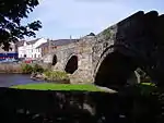 | |||
| Ravensheugh Road West Lodge Drummore | 55°56′49″N 3°01′15″W | Category C(S) | 38379 | | |||
| Windsor Gardens Gatepiers Facing Linkfield Road | 55°56′44″N 3°02′08″W | Category B | 38396 | | |||
| High Street Pinkie Pillars East Port | 55°56′37″N 3°02′44″W | Category B | 38291 | | |||
| 9 And 11 High Street | 55°56′37″N 3°02′47″W | Category C(S) | 38294 | | |||
| 23 High Street (At Rear Of Building Fronting High Street) Former Aerated Water/Lemonade Factory | 55°56′38″N 3°02′50″W | Category B | 38298 | | |||
| High Street Mercat Cross | 55°56′36″N 3°02′53″W | Category B | 38307 | | |||
| High Street, Pinkie House The Mansionhouse And Draw Well | 55°56′33″N 3°02′39″W | Category A | 38314 | 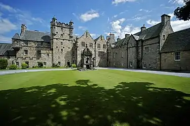 | |||
| 70 High Street | 55°56′34″N 3°02′54″W | Category C(S) | 38324 | | |||
| 128 & 130 High Street The Royal Esk | 55°56′32″N 3°03′02″W | Category B | 38328 | | |||
| 136 High Street | 55°56′33″N 3°03′03″W | Category C(S) | 38329 | | |||
| Inveresk Village Road St Michaels House, Gatepiers, Lodge And Stables | 55°56′12″N 3°03′17″W | Category B | 38331 | | |||
| 13, 15 And 17 Kilwinning Place | 55°56′33″N 3°02′59″W | Category C(S) | 38333 | | |||
| 6A Links Street, Congregational Church | 55°56′40″N 3°03′25″W | Category C(S) | 38345 | | |||
| 2-6 Mountjoy Terrace (Consecutive Numbers) | 55°56′50″N 3°03′14″W | Category C(S) | 38357 | | |||
| Royal Bank Of Scotland, Bridge Street | 55°56′35″N 3°03′24″W | Category B | 38259 | | |||
| 23 Dalrymple Loan, Belleville | 55°56′28″N 3°03′12″W | Category C(S) | 38267 | | |||
| 5 And 6 Eskside West | 55°56′41″N 3°03′06″W | Category C(S) | 38275 | | |||
| 12 Eskside West | 55°56′36″N 3°03′15″W | Category C(S) | 38277 | | |||
| 16 And 17 Eskside West | 55°56′35″N 3°03′17″W | Category C(S) | 38280 | | |||
| 101 And 103 North High Street Melville House | 55°56′39″N 3°03′29″W | Category C(S) | 38368 | | |||
| 150 And 152 North High Street | 55°56′37″N 3°03′42″W | Category C(S) | 38375 | | |||
| 2 Shorthope Street | 55°56′34″N 3°03′05″W | Category C(S) | 38384 | | |||
| Stoneyhill House | 55°56′22″N 3°04′01″W | Category B | 38389 | | |||
| Fisherrow Harbour | 55°56′44″N 3°04′03″W | Category B | 38287 | | |||
| 61, 61A High Street | 55°56′36″N 3°02′55″W | Category C(S) | 38306 | | |||
| 86, 88 And 90 High Street Corner Of Kilwinning Street | 55°56′34″N 3°02′56″W | Category C(S) | 38327 | | |||
| Linkfield Road Loretto School Doocot | 55°56′41″N 3°02′47″W | Category B | 38337 | | |||
| Linkfield Road Loretto School Colin Thomson Hall | 55°56′43″N 3°02′48″W | Category B | 38338 | | |||
| 9 And 11 Linkfield Road | 55°56′44″N 3°02′30″W | Category C(S) | 38339 | | |||
| 1 Millhill Linkfield Cottage | 55°56′45″N 3°02′35″W | Category B | 38347 | | |||
| 96 And 98 Newbigging | 55°56′23″N 3°02′54″W | Category C(S) | 38361 | | |||
| 10 Balcarres Road Formerly Edinburgh Burgess Golfing Society | 55°56′51″N 3°02′49″W | Category B | 38249 | | |||
| 25 Dalrymple Loan, Glengyle House With Boundary Walls | 55°56′27″N 3°03′11″W | Category C(S) | 38268 | | |||
| 31 And 33 Dalrymple Loan | 55°56′27″N 3°03′10″W | Category C(S) | 38270 | | |||
| 30 Eskside West | 55°56′32″N 3°03′23″W | Category C(S) | 38283 | | |||
| 253 North High Street Spring Bank | 55°56′39″N 3°03′53″W | Category B | 38370 | | |||
| Stoneyhill Former Steading David Lowe & Sons Ltd | 55°56′21″N 3°03′56″W | Category B | 38388 | | |||
| 49 High Street, Musselburgh Arms Hotel | 55°56′36″N 3°02′53″W | Category B | 38303 | | |||
| High Street, Pinkie House Lodge And Gatepiers | 55°56′37″N 3°02′42″W | Category B | 38315 | | |||
| High Street Pinkie House Stables | 55°56′37″N 3°02′40″W | Category B | 38316 | | |||
| 12, 14 And 16 High Street | 55°56′35″N 3°02′47″W | Category B | 38321 | | |||
| 76-84 High Street (Even Numbers) | 55°56′34″N 3°02′55″W | Category C(S) | 38326 | | |||
| High Street High Church (Church Of Scotland) | 55°56′31″N 3°03′15″W | Category B | 38330 | | |||
| 113, 115 And 117 Millhill | 55°56′38″N 3°03′03″W | Category B | 38353 | | |||
| Newfield Loretto School Sports Pavilion | 55°56′47″N 3°03′01″W | Category B | 38364 | | |||
| 97 New Street Forth Yacht Club | 55°56′42″N 3°03′51″W | Category C(S) | 38365 | | |||
| 18 And 20 Bridge Street | 55°56′36″N 3°03′27″W | Category B | 38261 | | |||
| 39 And 41 Dalrymple Loan | 55°56′26″N 3°03′10″W | Category C(S) | 38272 | | |||
| 1 And 2 Eskside West | 55°56′43″N 3°03′04″W | Category C(S) | 38273 | | |||
| 3 And 4 Eskside West | 55°56′42″N 3°03′05″W | Category C(S) | 38274 | | |||
| 10 North High Street M & F Co-Operative Society, Former Butchery Department | 55°56′38″N 3°03′18″W | Category B | 38371 | | |||
| 47 High Street | 55°56′37″N 3°02′53″W | Category B | 38302 | | |||
| 55 And 57 High Street | 55°56′36″N 3°02′54″W | Category B | 38305 | | |||
| High Street Town House | 55°56′35″N 3°02′56″W | Category A | 38308 | | |||
| High Street Pinkie House Doocot | 55°56′40″N 3°02′27″W | Category B | 38318 | | |||
| 72 And 74 High Street The Inn Place | 55°56′34″N 3°02′54″W | Category C(S) | 38325 | | |||
| 15 Linkfield Road | 55°56′43″N 3°02′28″W | Category B | 38341 | | |||
| Newbigging Our Lady Of Loretto And St Michael R C Church | 55°56′30″N 3°02′54″W | Category B | 38358 | | |||
| New Bridge Between Bridge Street And High Street | 55°56′32″N 3°03′17″W | Category B | 38363 | | |||
| 8 Bridge Street | 55°56′34″N 3°03′22″W | Category B | 38258 | | |||
| 29 Dalrymple Loan, Primrose House | 55°56′27″N 3°03′10″W | Category B | 38269 | | |||
| 13 Eskside West | 55°56′36″N 3°03′15″W | Category C(S) | 38278 | | |||
| 102, 104 And 106 North High Street | 55°56′37″N 3°03′35″W | Category B | 38373 | | |||
| 180 North High Street Jane Cottage | 55°56′38″N 3°03′50″W | Category C(S) | 38377 | | |||
| Station Road Esk Mills | 55°56′19″N 3°03′35″W | Category B | 38386 | | |||
| 7 High Street | 55°56′37″N 3°02′46″W | Category B | 38293 | | |||
| 15 High Street (Formerly Parsonage House) Including Gatepiers And Walls | 55°56′39″N 3°02′50″W | Category B | 38296 | | |||
| 51 And 53 High Street | 55°56′36″N 3°02′54″W | Category C(S) | 38304 | | |||
| High Street Tolbooth | 55°56′35″N 3°02′56″W | Category A | 38309 | | |||
| High Street, St Peter's Church (Episcopal) | 55°56′36″N 3°02′43″W | Category B | 38319 | | |||
| 18 And 20 High Street | 55°56′35″N 3°02′47″W | Category B | 38322 | | |||
| Linkfield Road Loretto School Gate-Lodge And Gatepiers | 55°56′43″N 3°02′35″W | Category B | 38335 | | |||
| 69 Millhill | 55°56′40″N 3°02′58″W | Category C(S) | 38350 | | |||
| 1 Mountjoy Terrace | 55°56′49″N 3°03′14″W | Category C(S) | 38356 | | |||
| 107 Newbigging | 55°56′22″N 3°02′53″W | Category C(S) | 38359 | | |||
| Newbigging Lewisvale Public Park, Bandstand | 55°56′20″N 3°02′44″W | Category B | 38362 | | |||
| 11 And 12 Balcarres Road | 55°56′51″N 3°02′49″W | Category C(S) | 38250 | | |||
| 47 Bridge Street | 55°56′36″N 3°03′24″W | Category B | 38255 | | |||
| 28 Eskside West | 55°56′33″N 3°03′22″W | Category C(S) | 38281 | |
Key
The scheme for classifying buildings in Scotland is:
- Category A: "buildings of national or international importance, either architectural or historic; or fine, little-altered examples of some particular period, style or building type."[1]
- Category B: "buildings of regional or more than local importance; or major examples of some particular period, style or building type, which may have been altered."[1]
- Category C: "buildings of local importance; lesser examples of any period, style, or building type, as originally constructed or moderately altered; and simple traditional buildings which group well with other listed buildings."[1]
In March 2016 there were 47,288 listed buildings in Scotland. Of these, 8% were Category A, and 50% were Category B, with the remaining 42% being Category C.[2]
Notes
- Sometimes known as OSGB36, the grid reference (where provided) is based on the British national grid reference system used by the Ordnance Survey.
• "Guide to National Grid". Ordnance Survey. Retrieved 12 December 2007.
• "Get-a-map". Ordnance Survey. Retrieved 17 December 2007. - Historic Environment Scotland assign a unique alphanumeric identifier to each designated site in Scotland, for listed buildings this always begins with "LB", for example "LB12345".
References
- All entries, addresses and coordinates are based on data from Historic Scotland. This data falls under the Open Government Licence
- "What is Listing?". Historic Environment Scotland. Retrieved 29 May 2018.
- Scotland's Historic Environment Audit 2016 (PDF). Historic Environment Scotland and the Built Environment Forum Scotland. pp. 15–16. Retrieved 29 May 2018.
This article is issued from Wikipedia. The text is licensed under Creative Commons - Attribution - Sharealike. Additional terms may apply for the media files.