List of listed buildings in Nairn, Highland
List
| Name | Location | Date Listed | Grid Ref. [note 1] | Geo-coordinates | Notes | LB Number [note 2] | Image |
|---|---|---|---|---|---|---|---|
| 8 And 9 Bath Street | 57°35′12″N 3°52′15″W | Category B | 38407 | 
| |||
| Cawdor Street, War Memorial, Enclosing Wall And Piers | 57°34′55″N 3°52′17″W | Category B | 38409 | 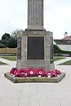
| |||
| Church Road, Former Parish Church | 57°34′58″N 3°51′57″W | Category C(S) | 38411 |
| |||
| Crescent Road 1 And 2 Balvenie Place | 57°35′11″N 3°52′09″W | Category C(S) | 38416 | 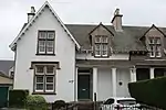
| |||
| 6 And 8 Cumming Street | 57°35′14″N 3°52′10″W | Category C(S) | 38418 |
| |||
| 10 And 12 Cumming Street Beach Lea | 57°35′15″N 3°52′10″W | Category C(S) | 38419 |
| |||
| Waverley Hotel And 4,6,8,10,12,14 High Street | 57°35′01″N 3°52′14″W | Category C(S) | 38423 | 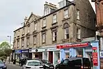
| |||
| 79 And 79A High Street, (Department Of Employment, And Peggys) | 57°35′06″N 3°52′02″W | Category B | 38436 | 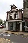
| |||
| High Street, Bank Of Scotland | 57°35′06″N 3°52′04″W | Category B | 38438 | 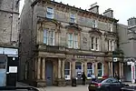
| |||
| 57 High Street, The Victoria Hotel | 57°35′04″N 3°52′06″W | Category C(S) | 38440 |
| |||
| Nairn Railway Station, Main Offices North (Down) Platform, Passenger Shelter And Ancillary Buildings, South (Up) Platform And Footbridge | 57°34′48″N 3°52′19″W | Category B | 38454 | 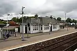
| |||
| Nairn Railway Station, West And East Signal Boxes North (Down) Platform | 57°34′51″N 3°52′12″W | Category B | 38455 |
| |||
| Altonburn Road, Alltan Donn House Including 1, 2, 3 Tradespark Road | 57°35′02″N 3°54′00″W | Category B | 49638 |
| |||
| Academy Street, Old Parish Church | 57°35′01″N 3°52′35″W | Category A | 38400 |
| |||
| Church Road, Former School (C G Higgins & Co) | 57°35′01″N 3°52′00″W | Category C(S) | 38412 |
| |||
| Crescent Road, Rawcliffe | 57°35′13″N 3°52′08″W | Category B | 38417 |
| |||
| High Street, Courthouse (Town And County Buildings) | 57°35′06″N 3°52′07″W | Category B | 38427 |
| |||
| 75-77 High Street | 57°35′06″N 3°52′04″W | Category C(S) | 38437 | 
| |||
| 61 High Street, (The Brass Kettle) | 57°35′05″N 3°52′07″W | Category C(S) | 38439 |
| |||
| Inverness Road, Newton Court | 57°35′01″N 3°53′08″W | Category B | 38444 |
| |||
| 1 Marine Road And 2 Charles Place | 57°35′14″N 3°52′11″W | Category C(S) | 38451 |
| |||
| Meikle Kildrummie | 57°33′38″N 3°54′52″W | Category B | 14057 |
| |||
| Delnies Sandwood And Gate Lodge | 57°34′31″N 3°54′35″W | Category B | 14062 |
| |||
| Crescent Road, Havelock Hotel | 57°35′13″N 3°52′10″W | Category C(S) | 38415 |
| |||
| High Street, Mackintosh`S Buildings | 57°35′08″N 3°52′03″W | Category B | 38430 | 
| |||
| 125 And 117 High Street | 57°35′09″N 3°51′58″W | Category C(S) | 38432 | 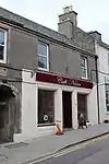
| |||
| Off King Street, Viewfield, Statue To Dr John Grigor(1814-1866) | 57°35′09″N 3°52′25″W | Category B | 38448 |
| |||
| 2 Wellington Road Gate Piers And Garden Walls | 57°34′59″N 3°52′20″W | Category B | 38462 |
| |||
| Househill Househill Gate Lodge | 57°34′34″N 3°51′42″W | Category C(S) | 14056 |
| |||
| Delnies Beldorney | 57°34′32″N 3°54′58″W | Category B | 14060 |
| |||
| Academy Street, Nairn Rosebank Parish Church Hall | 57°35′03″N 3°52′21″W | Category B | 38402 |
| |||
| 4 And 6 Courthouse Lane | 57°35′07″N 3°52′09″W | Category B | 38413 |
| |||
| 1, 2, 3 And 4 Gordon Street (Corner Site With 94 High Street) | 57°35′09″N 3°52′01″W | Category B | 38420 | 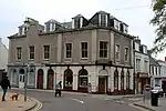
| |||
| High Street, Royal Bank Of Scotland (Formerly The National Bank Of Scotland) | 57°35′04″N 3°52′11″W | Category B | 38425 |
| |||
| 113 And 109 High Street | 57°35′09″N 3°51′59″W | Category C(S) | 38433 | 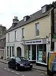
| |||
| 17 And 19 High Street, Clydesdale Bank | 57°35′02″N 3°52′11″W | Category C(S) | 38441 | 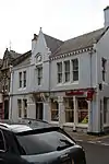
| |||
| 20 Queen Street, Scorrybreck | 57°34′58″N 3°52′05″W | Category C(S) | 38453 |
| |||
| Seabank Road, Broomholm, Broomholm Cottage And Boundary_Walling | 57°35′13″N 3°53′12″W | Category B | 38458 |
| |||
| 58 Seabank Road, Linkside, Linkside Cottage And Boundary Wall | 57°35′14″N 3°53′17″W | Category B | 38459 |
| |||
| Tradespark Road, Willowvale | 57°34′57″N 3°53′53″W | Category B | 38460 |
| |||
| Leopold Street, Former Up Manse | 57°35′02″N 3°52′18″W | Category B | 38463 |
| |||
| Geddes St Mary's Chapel And Graveyard | 57°33′08″N 3°51′34″W | Category B | 14053 |
| |||
| Rait Castle | 57°32′57″N 3°51′00″W | Category A | 14058 |
| |||
| Geddes House | 57°33′00″N 3°52′01″W | Category B | 14063 |
| |||
| Albert Street, Lion Cottage And Garden Wall | 57°35′06″N 3°52′30″W | Category B | 38405 |
| |||
| Albert Street, Tarland | 57°35′17″N 3°53′14″W | Category B | 38406 |
| |||
| Crescent Road, Kingillie | 57°35′13″N 3°52′17″W | Category B | 38414 |
| |||
| High Street, Jubilee Fountain | 57°35′00″N 3°52′15″W | Category C(S) | 38422 | 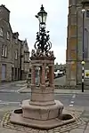
| |||
| High Street, Royal Hotel | 57°35′07″N 3°52′04″W | Category B | 38429 | 
| |||
| 88 High Street (Tulloch) | 57°35′08″N 3°52′02″W | Category B | 38431 | 
| |||
| 103 High Street | 57°35′08″N 3°52′00″W | Category B | 38435 | 
| |||
| Inverness Road, Newton Hotel And Fountain | 57°35′02″N 3°53′03″W | Category B | 38443 |
| |||
| Queen Street, St Columba`S Episcopal Church | 57°34′57″N 3°52′08″W | Category C(S) | 38452 |
| |||
| Househill, House And Stables | 57°34′28″N 3°51′39″W | Category C(S) | 14059 |
| |||
| High Street, Market Cross | 57°35′05″N 3°52′07″W | Category B | 38428 |
| |||
| Off King Street, Viewfield | 57°35′10″N 3°52′27″W | Category B | 38447 |
| |||
| Tulloch Crescent, Woodville | 57°34′51″N 3°52′35″W | Category B | 38461 |
| |||
| Geddes Heathmount | 57°32′40″N 3°52′18″W | Category B | 14055 |
| |||
| Academy Street, St Mary`S Roman Catholic Church And Manse | 57°35′03″N 3°52′28″W | Category C(S) | 38403 |
| |||
| High Street, Straith Monument | 57°34′59″N 3°52′16″W | Category C(S) | 38421 | 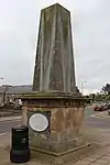
| |||
| High Street,Highland(Formerly Station Hotel) On Corner With Leopold Street | 57°35′02″N 3°52′13″W | Category B | 38424 | 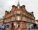
| |||
| 24-30 High Street Rose Bros And Co (Even Nos) | 57°35′04″N 3°52′10″W | Category B | 38426 |
| |||
| High Street, Constabulary Gardens With Gatepiers And Railings | 57°35′07″N 3°51′59″W | Category C(S) | 38434 |
| |||
| Marine Road, Bandstand | 57°35′16″N 3°52′16″W | Category A | 38450 | .jpg.webp)
| |||
| Geddes House Steading, Stables And Carriage House Walled Garden | 57°33′02″N 3°52′11″W | Category C(S) | 14052 |
| |||
| Market Stance Cottage By St. Mary's Chapel | 57°33′07″N 3°51′32″W | Category C(S) | 14054 |
| |||
| Delnies Delniesmuir And Gate Lodge | 57°34′32″N 3°55′04″W | Category B | 14061 |
| |||
| Cawdor Road, Nairn Town And County Hospital | 57°34′41″N 3°52′21″W | Category C(S) | 49942 |
| |||
| Academy Street, Nairn Rosebank Parish Church (Formerly Nairn Up Church) | 57°35′03″N 3°52′20″W | Category B | 38401 |
| |||
| Altonburn Road, Achareidh House | 57°35′01″N 3°53′40″W | Category B | 38404 |
| |||
| Bridge Street, Road Bridge Over Nairn River | 57°35′09″N 3°51′53″W | Category B | 38408 | 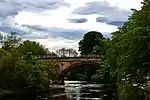
| |||
| Cawdor Street, British Legion Club; House, Gatepiers And_Walling To Cawdor Street | 57°34′57″N 3°52′15″W | Category B | 38410 | 
| |||
| High Street, St Ninian`S Church And Parish Hall | 57°34′59″N 3°52′14″W | Category B | 38442 |
| |||
| King Street, Congregational Church | 57°35′12″N 3°52′07″W | Category C(S) | 38445 | 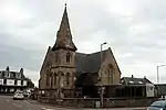
| |||
| King Street, Roseneath House | 57°35′13″N 3°52′03″W | Category C(S) | 38446 |
| |||
| Manse Road, Old Parish Church Manse | 57°35′02″N 3°52′38″W | Category B | 38449 |
| |||
| Nairn Viaduct Over River Nairn | 57°34′57″N 3°51′53″W | Category B | 38457 |
|
Key
The scheme for classifying buildings in Scotland is:
- Category A: "buildings of national or international importance, either architectural or historic; or fine, little-altered examples of some particular period, style or building type."[1]
- Category B: "buildings of regional or more than local importance; or major examples of some particular period, style or building type, which may have been altered."[1]
- Category C: "buildings of local importance; lesser examples of any period, style, or building type, as originally constructed or moderately altered; and simple traditional buildings which group well with other listed buildings."[1]
In March 2016 there were 47,288 listed buildings in Scotland. Of these, 8% were Category A, and 50% were Category B, with the remaining 42% being Category C.[2]
See also
Notes
- Sometimes known as OSGB36, the grid reference (where provided) is based on the British national grid reference system used by the Ordnance Survey.
• "Guide to National Grid". Ordnance Survey. Retrieved 12 December 2007.
• "Get-a-map". Ordnance Survey. Retrieved 17 December 2007. - Historic Environment Scotland assign a unique alphanumeric identifier to each designated site in Scotland, for listed buildings this always begins with "LB", for example "LB12345".
References
- All entries, addresses and coordinates are based on data from Historic Scotland. This data falls under the Open Government Licence
- "What is Listing?". Historic Environment Scotland. Retrieved 29 May 2018.
- Scotland's Historic Environment Audit 2016 (PDF). Historic Environment Scotland and the Built Environment Forum Scotland. pp. 15–16. Retrieved 29 May 2018.
This article is issued from Wikipedia. The text is licensed under Creative Commons - Attribution - Sharealike. Additional terms may apply for the media files.