List of listed buildings in Old Deer, Aberdeenshire
List
| Name | Location | Date Listed | Grid Ref. [note 1] | Geo-coordinates | Notes | LB Number [note 2] | Image |
|---|---|---|---|---|---|---|---|
| North-East Bridge The Lake, Pitfour (Captain Curzon) | 57°31′47″N 2°02′05″W | Category B | 19773 | 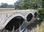 | |||
| Saplinbrae | 57°31′32″N 2°02′49″W | Category B | 16061 |  | |||
| South Lodge Gates, Pitfour | 57°31′30″N 2°02′17″W | Category B | 16063 | | |||
| 1, 3, 5 Kirkgate | 57°31′09″N 2°02′14″W | Category C(S) | 16086 | | |||
| Deer Abbey, Enclosing Wall And Adjoining Walled Garden | 57°31′24″N 2°03′06″W | Category B | 16105 | | |||
| St. Drestan's Episcopal Church, Old Deer | 57°31′09″N 2°02′17″W | Category B | 16116 | | |||
| The Stables, Pitfour (Mr. Watson) | 57°31′59″N 2°02′07″W | Category B | 16070 | | |||
| Windhill Farm | 57°30′32″N 2°04′50″W | Category B | 16103 | | |||
| Parish Church | 57°31′09″N 2°02′13″W | Category B | 16113 | | |||
| 4,6 Kirkgate | 57°31′08″N 2°02′15″W | Category C(S) | 13882 | | |||
| Pitfour Estate,Station Lodge,Including Gates And Gatepiers | 57°31′43″N 2°01′38″W | Category C(S) | 18834 | | |||
| North Auchmachar, Farmhouse | 57°32′42″N 2°04′37″W | Category B | 16078 | | |||
| North Lodge, Aden | 57°31′34″N 2°01′37″W | Category C(S) | 16097 | | |||
| 1 Abbey Street And 2 Kirkgate Old Deer | 57°31′09″N 2°02′15″W | Category B | 16115 | | |||
| Aden Country Park, Walled Garden Including Bothy, Potting Shed And Head Gardener's House | 57°31′15″N 2°01′50″W | Category C(S) | 50906 | | |||
| 13, 15, 17 Abbey Street | 57°31′10″N 2°02′21″W | Category C(S) | 19774 | | |||
| Pitfour West Lodge | 57°32′10″N 2°04′46″W | Category C(S) | 18963 | | |||
| Bruxie Lodge, Pitfour | 57°31′45″N 2°04′06″W | Category B | 16064 | | |||
| Temple Of Theseus, The Lake, Pitfour (Captain Curzon) | 57°31′42″N 2°02′38″W | Category B | 16068 | | |||
| The Larder, Pitfour (Mr. Watson) | 57°32′01″N 2°02′17″W | Category C(S) | 16071 | | |||
| The Observatory, Drinnie's Wood, Pitfour (Forestry Commission) | 57°32′20″N 2°02′45″W | Category B | 16074 | | |||
| Emah Roo. (Old Tollhouse) Near Coilsmore | 57°32′04″N 2°05′35″W | Category C(S) | 16077 | | |||
| Aden Arms Hotel | 57°31′10″N 2°02′23″W | Category C(S) | 16082 | | |||
| 2, 4 Abbey Street | 57°31′10″N 2°02′16″W | Category C(S) | 16083 | | |||
| Bridge Of Deer Over South Ugie Water | 57°31′12″N 2°02′13″W | Category B | 16087 | | |||
| Aden Icehouse | 57°31′13″N 2°02′06″W | Category C(S) | 16094 | | |||
| Biffie Farmhouse | 57°30′56″N 2°02′57″W | Category B | 16098 | | |||
| Milladen, Mill | 57°30′46″N 2°01′43″W | Category B | 16100 | | |||
| 11 Abbey Street | 57°31′09″N 2°02′20″W | Category C(S) | 16118 | | |||
| Cheverton House | 57°30′46″N 2°02′24″W | Category B | 19775 | | |||
| Waulkmill, Quartalehouse | 57°30′28″N 2°02′35″W | Category B | 19776 | | |||
| Pitfour Estate, South Lodge | 57°31′30″N 2°02′18″W | Category C(S) | 18975 | | |||
| Ardallie Manse | 57°26′30″N 1°59′17″W | Category C(S) | 16058 | | |||
| 'The Boathouse', The Lake, Pitfour (Captain Curzon) | 57°31′48″N 2°02′37″W | Category C(S) | 16067 | 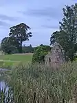 | |||
| The Kennels Cottage, Pitfour (Captain Curzon) | 57°31′53″N 2°02′42″W | Category B | 16069 | | |||
| Fetterangus Church | 57°32′43″N 2°01′58″W | Category C(S) | 16079 | | |||
| Old Bridge Of Gaval Over North Ugie Water | 57°33′20″N 2°00′36″W | Category B | 16080 | | |||
| Aden House | 57°31′14″N 2°02′04″W | Category B | 16093 | | |||
| 3, 5 Abbey Street | 57°31′09″N 2°02′18″W | Category C(S) | 16117 | | |||
| Aden Country Park, North East Folklore Archive, Former Laundry | 57°31′16″N 2°02′01″W | Category C(S) | 50905 | | |||
| Brae Of Coynach House | 57°29′12″N 2°01′04″W | Category B | 16055 | | |||
| Skelmuir House | 57°28′34″N 2°02′01″W | Category C(S) | 16056 | | |||
| Ardallie Church | 57°26′29″N 1°59′16″W | Category B | 16057 | | |||
| Cartlehaugh | 57°31′30″N 2°02′10″W | Category B | 16062 | | |||
| The Laundry, Pitfour (Mr. Watson) | 57°32′00″N 2°02′22″W | Category C(S) | 16072 | | |||
| Mill Of Clackriach, House | 57°31′13″N 2°06′32″W | Category C(S) | 16075 | | |||
| Mill Of Clackriach, Mill | 57°31′13″N 2°06′32″W | Category B | 16076 | | |||
| West Lodge, Aden | 57°31′17″N 2°02′15″W | Category C(S) | 16091 | | |||
| Brae Of Biffie Farmhouse | 57°30′29″N 2°03′25″W | Category B | 16099 | | |||
| Grain Mill, 31 Mill Street, Stuartfield | 57°30′04″N 2°02′49″W | Category B | 16102 | | |||
| Deer Abbey | 57°31′23″N 2°03′15″W | Category B | 16104 | | |||
| Newlands | 57°31′27″N 2°03′12″W | Category B | 16060 | | |||
| South East Bridge, The Lake Pitfour (Captain Curzon) | 57°31′40″N 2°02′13″W | Category C(S) | 16065 | | |||
| North-West Bridge, The Lake, Pitfour (Captain Curzon) | 57°31′50″N 2°02′49″W | Category C(S) | 16066 | | |||
| New Bridge Of Gaval Over North Ugie Water | 57°33′07″N 2°00′09″W | Category C(S) | 16081 | | |||
| Clydesdale Bank, Abbey Street | 57°31′10″N 2°02′17″W | Category B | 16084 | | |||
| Post Office, Abbey Street | 57°31′10″N 2°02′19″W | Category B | 16085 | | |||
| Manse Of Old Deer | 57°31′17″N 2°02′29″W | Category B | 16088 | | |||
| The Cottage, Russell Street | 57°31′07″N 2°02′25″W | Category C(S) | 16090 | | |||
| Bridge Over South Ugie Water In Aden Policies S Of Items 15 And 20 | 57°31′11″N 2°02′09″W | Category C(S) | 16095 | | |||
| Aden Country Park, Aberdeenshire Farming Museum Formerly Aden House Stables | 57°31′18″N 2°01′58″W | Category A | 16096 | | |||
| Old Parish Church And Churchyard | 57°31′10″N 2°02′12″W | Category B | 16114 | | |||
| Abbey Bridge | 57°31′24″N 2°03′28″W | Category B | 16059 | | |||
| The Chapel, Pitfour (Mr. Watson) | 57°31′56″N 2°01′54″W | Category C(S) | 16073 | | |||
| Manse Of Old Deer, Offices | 57°31′15″N 2°02′27″W | Category C(S) | 16089 | | |||
| Bridge Over South Ugie Water In Aden Policies E Of Bridge Of Deer | 57°31′07″N 2°02′09″W | Category C(S) | 16092 | | |||
| The Sycamores, Quartalehouse | 57°30′29″N 2°02′34″W | Category C(S) | 16101 | |
Key
The scheme for classifying buildings in Scotland is:
- Category A: "buildings of national or international importance, either architectural or historic; or fine, little-altered examples of some particular period, style or building type."[1]
- Category B: "buildings of regional or more than local importance; or major examples of some particular period, style or building type, which may have been altered."[1]
- Category C: "buildings of local importance; lesser examples of any period, style, or building type, as originally constructed or moderately altered; and simple traditional buildings which group well with other listed buildings."[1]
In March 2016 there were 47,288 listed buildings in Scotland. Of these, 8% were Category A, and 50% were Category B, with the remaining 42% being Category C.[2]
Notes
- Sometimes known as OSGB36, the grid reference (where provided) is based on the British national grid reference system used by the Ordnance Survey.
• "Guide to National Grid". Ordnance Survey. Retrieved 2007-12-12.
• "Get-a-map". Ordnance Survey. Retrieved 2007-12-17. - Historic Environment Scotland assign a unique alphanumeric identifier to each designated site in Scotland, for listed buildings this always begins with "LB", for example "LB12345".
References
- All entries, addresses and coordinates are based on data from Historic Scotland. This data falls under the Open Government Licence
- "What is Listing?". Historic Environment Scotland. Retrieved 29 May 2018.
- Scotland's Historic Environment Audit 2016 (PDF). Historic Environment Scotland and the Built Environment Forum Scotland. pp. 15–16. Retrieved 29 May 2018.
This article is issued from Wikipedia. The text is licensed under Creative Commons - Attribution - Sharealike. Additional terms may apply for the media files.