List of listed buildings in Peterculter, Aberdeen
List
| Name | Location | Date Listed | Grid Ref. [note 1] | Geo-coordinates | Notes | LB Number [note 2] | Image |
|---|---|---|---|---|---|---|---|
| Parish Church Of St. Peter Peterculter | 57°05′41″N 2°15′47″W | Category C(S) | 19753 |  | |||
| Cults House, Garden Wall | 57°07′03″N 2°10′55″W | Category B | 15771 | | |||
| Mill Of Cults, Millden Road, | 57°07′04″N 2°10′23″W | Category C(S) | 15772 | | |||
| Pitfodels North Deeside Road Pitfodels House | 57°07′19″N 2°09′22″W | Category C(S) | 15784 | | |||
| St. Peter's Manse Peterculter | 57°05′40″N 2°15′51″W | Category B | 15713 | | |||
| Kennerty House | 57°05′42″N 2°16′34″W | Category B | 15716 | | |||
| Upper Anguston, Farmhouse | 57°06′38″N 2°19′23″W | Category C(S) | 15722 | | |||
| Murtle House | 57°06′14″N 2°12′42″W | Category B | 15730 | | |||
| St. Devenick's Episcopal Church, Bieldside | 57°06′47″N 2°11′48″W | Category B | 19756 | | |||
| Cults Old School | 57°06′57″N 2°10′53″W | Category C(S) | 15770 | | |||
| Pitfodels, North Deeside Road Woodbank With Walled Garden, Terrace And Gatepiers | 57°07′24″N 2°09′34″W | Category C(S) | 15785 | | |||
| Culter House Walled Garden, Gazebo, Dovecot And Gatepiers | 57°06′10″N 2°15′27″W | Category B | 15715 | | |||
| Lower Kennerty Mill | 57°05′39″N 2°16′10″W | Category C(S) | 15718 | | |||
| Peterculter Old Free Church, Contlaw | 57°06′55″N 2°15′46″W | Category C(S) | 15723 | | |||
| March Stone No 24 To The West Of The Farm Buildings Of North Westfield | 57°07′34″N 2°15′33″W | Category B | 15727 | | |||
| Ellengowan | 57°07′34″N 2°11′29″W | Category B | 15735 | | |||
| Kaim House | 57°07′06″N 2°08′23″W | Category B | 15782 | | |||
| Mill Of Murtle | 57°06′32″N 2°12′44″W | Category C(S) | 15689 | | |||
| Ladyhill House | 57°07′24″N 2°12′36″W | Category B | 15693 | | |||
| Morrison's Bridge (The Shakkin' Briggie) Over River Dee | 57°06′52″N 2°10′14″W | Category A | 15733 | 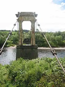 | |||
| Greenridge (Formerly Morkeu House) Cults | 57°07′27″N 2°10′27″W | Category B | 15734 | | |||
| March Stone No. 17 About 150 Yards West Of The Belt Of Trees Containing No 16 Near A Cairn Of Field Gatherings | 57°07′08″N 2°13′09″W | Category B | 15741 | | |||
| March Stone No. 18 At The Head Of Den Of Murtle On And To N. Of Farm Of Hilton | 57°07′12″N 2°13′37″W | Category B | 15742 | | |||
| March Stone No. 20 On The Line Of The Same Dyke As No. 19 To The West | 57°07′14″N 2°14′13″W | Category B | 15744 | | |||
| Countesswells House Doocot | 57°07′43″N 2°12′45″W | Category C(S) | 15748 | | |||
| Cults, Pitfodels Station Road, Former Station Building | 57°07′14″N 2°09′22″W | Category C(S) | 51183 | | |||
| Windmill, Drumgarth, Garthdee Road | 57°07′03″N 2°09′19″W | Category C(S) | 15779 | | |||
| Norwood, Garthdee Road | 57°07′03″N 2°09′02″W | Category B | 15780 | | |||
| Milton Of Murtle | 57°06′33″N 2°12′43″W | Category C(S) | 15690 | | |||
| Fairview, Inchagarth Road | 57°06′55″N 2°10′14″W | Category B | 15732 | | |||
| March Stone No. 14 On The Farm Of Hillhead Of Cults N.W. Of The Farmbuildings At The Edge Of A Field | 57°07′09″N 2°11′50″W | Category B | 15738 | | |||
| Garthdee Road, Garthdee House (Scott Sutherland School Of Architecture), Including Terrace Walls And Steps, East And West Lodges | 57°07′08″N 2°08′35″W | Category B | 47908 | | |||
| Cults, North Deeside Road Wellwood | 57°07′17″N 2°09′59″W | Category C(S) | 15786 | | |||
| Inchgarth, Garthdee Road | 57°07′05″N 2°09′27″W | Category C(S) | 15711 | | |||
| Waulkmill Bridge Over Culter Burn | 57°06′13″N 2°17′25″W | Category B | 15720 | | |||
| Nether Anguston, Farmhouse | 57°06′19″N 2°18′51″W | Category B | 15721 | | |||
| March Stone No. 23 At Top Of Beans Hill | 57°07′21″N 2°15′17″W | Category B | 15726 | | |||
| Cults House | 57°07′03″N 2°10′58″W | Category B | 15731 | | |||
| March Stone No. 12. On Craigton Road Below Cults Dam | 57°07′04″N 2°11′00″W | Category B | 15736 | | |||
| March Stone No. 13 In A Quarry N.W. Of Mains Of Cults | 57°07′14″N 2°11′30″W | Category B | 15737 | | |||
| March Stone No. 15 In A Field South Of Bellyswells Farm And Beside 4 Dressed Stones Marked 1-4 Which Mark The Springs Of Cults Water Supply | 57°07′08″N 2°12′27″W | Category B | 15739 | | |||
| March Stone No. 21. On A Knoll West Of The Farm Of Westfield | 57°07′17″N 2°14′39″W | Category B | 15745 | | |||
| Countesswells House | 57°07′45″N 2°12′54″W | Category B | 15747 | | |||
| Murtleden, Inchyra Road | 57°06′51″N 2°13′16″W | Category B | 15692 | | |||
| Bieldside House Including Railing And Gates | 57°06′47″N 2°11′30″W | Category B | 15695 | | |||
| Mill Of Brotherfield, Bridge Over Brodiach Burn At Easter Ord | 57°07′58″N 2°16′31″W | Category C(S) | 15725 | | |||
| March Stone No. 26 At The Confluence Of The Ord Or Brodiach Burn With The Rotten Or Silver Burn | 57°07′44″N 2°16′37″W | Category B | 15729 | | |||
| March Stone No. 19. At The N.W. Head Of The Den Of Murtle On The Farm Of West Field At The Side Of A Field | 57°07′14″N 2°14′04″W | Category B | 15743 | | |||
| March Stone No. 22 On Another Knoll West Of The Farm Of Westfield | 57°07′18″N 2°14′48″W | Category B | 15746 | | |||
| Murtle Sawmill (Don Contractors Ltd.) | 57°06′23″N 2°12′45″W | Category C(S) | 19754 | | |||
| March Stone No 27 South Of Easter Ord And South-West Of A Footbridge | 57°07′47″N 2°16′37″W | Category B | 15783 | | |||
| Murtle Cottage, 151 Deeside Road, Bieldside | 57°06′39″N 2°12′24″W | Category B | 15691 | | |||
| Ladyhill House Lodge | 57°07′23″N 2°12′34″W | Category B | 15694 | | |||
| St. Peter's Churchyard, Peterculter | 57°05′41″N 2°15′47″W | Category C(S) | 15712 | | |||
| Upper Kennerty Mills | 57°05′41″N 2°16′20″W | Category B | 15717 | | |||
| March Stone No. 16 In A Belt Of Trees North Of The Gardeners Cottage At Dalmuinzie Adjoining Foggreton Muir | 57°07′07″N 2°12′53″W | Category B | 15740 | | |||
| North Deeside Road At Craigton Crescent, Peterculter Parish Church (Church Of Scotland), Including Boundary Walls | 57°05′48″N 2°15′53″W | Category C(S) | 47267 | | |||
| Cults West Church | 57°06′52″N 2°11′21″W | Category B | 15769 | | |||
| Norwood Lodge, Garthdee Road | 57°07′09″N 2°09′12″W | Category C(S) | 15781 | | |||
| Culter House (St. Margaret's School For Girls Boarding House) | 57°06′10″N 2°15′28″W | Category A | 15714 | | |||
| Kennerty Bridge | 57°05′44″N 2°16′22″W | Category B | 15719 | | |||
| Mill Of Brotherfield | 57°07′58″N 2°16′30″W | Category C(S) | 15724 | | |||
| March Stone No 25 On The S.E. Face Of Brunt Hill Near The Rotten Or Silver Burn | 57°07′40″N 2°15′43″W | Category B | 15728 | |
Key
The scheme for classifying buildings in Scotland is:
- Category A: "buildings of national or international importance, either architectural or historic; or fine, little-altered examples of some particular period, style or building type."[1]
- Category B: "buildings of regional or more than local importance; or major examples of some particular period, style or building type, which may have been altered."[1]
- Category C: "buildings of local importance; lesser examples of any period, style, or building type, as originally constructed or moderately altered; and simple traditional buildings which group well with other listed buildings."[1]
In March 2016 there were 47,288 listed buildings in Scotland. Of these, 8% were Category A, and 50% were Category B, with the remaining 42% being Category C.[2]
See also
Notes
- Sometimes known as OSGB36, the grid reference (where provided) is based on the British national grid reference system used by the Ordnance Survey.
• "Guide to National Grid". Ordnance Survey. Retrieved 12 December 2007.
• "Get-a-map". Ordnance Survey. Retrieved 17 December 2007. - Historic Environment Scotland assign a unique alphanumeric identifier to each designated site in Scotland, for listed buildings this always begins with "LB", for example "LB12345".
References
- All entries, addresses and coordinates are based on data from Historic Scotland. This data falls under the Open Government Licence
- "What is Listing?". Historic Environment Scotland. Retrieved 29 May 2018.
- Scotland's Historic Environment Audit 2016 (PDF). Historic Environment Scotland and the Built Environment Forum Scotland. pp. 15–16. Retrieved 29 May 2018.
This article is issued from Wikipedia. The text is licensed under Creative Commons - Attribution - Sharealike. Additional terms may apply for the media files.