List of listed buildings in St Cyrus, Aberdeenshire
List
| Name | Location | Date Listed | Grid Ref. [note 1] | Geo-coordinates | Notes | LB Number [note 2] | Image |
|---|---|---|---|---|---|---|---|
| Parish Church Of Garvock-St Cyrus, Including Area Walls, Churchyard Gates And Railings, And Remains Of Previous Church | 56°46′26″N 2°24′36″W | Category B | 16317 |  | |||
| Ecclesgreig House Including Terraces, Steps, And Graden Ornaments | 56°47′01″N 2°25′50″W | Category B | 16323 | | |||
| Denfinella Bridge | 56°47′22″N 2°22′32″W | Category B | 16327 | | |||
| Kaim Of Mathers | 56°46′31″N 2°23′22″W | Category C(S) | 16322 | | |||
| Bervie Branch Railway Viaduct Over North Esk | 56°45′04″N 2°27′04″W | Category B | 16331 | 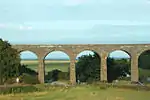 | |||
| Burnside, St Cyrus | 56°46′32″N 2°25′02″W | Category C(S) | 16321 | | |||
| Lauriston Castle | 56°47′25″N 2°23′33″W | Category C(S) | 16324 | | |||
| Mill Of Morphy House | 56°45′22″N 2°28′12″W | Category B | 16329 | | |||
| Main Road, St Cyrus Church Hall Including Boundary Walls | 56°46′31″N 2°24′54″W | Category C(S) | 49198 | | |||
| St Cyrus School | 56°46′24″N 2°24′40″W | Category B | 16318 | | |||
| Manse Of Garvock-St Cyrus, St Cyrus | 56°46′19″N 2°24′47″W | Category C(S) | 16319 | | |||
| Churchgate Cottage (T B Craig) Near Garvock-St Cyrus Church On North | 56°46′27″N 2°24′41″W | Category C(S) | 16320 | | |||
| Woodston Fishing Station, Former Skipper's Quarters, Bothy And Ice House | 56°46′30″N 2°23′59″W | Category B | 47357 | | |||
| Forebank House Including Steading Outbuildings, Garden Walls Railings And Gates | 56°46′23″N 2°29′27″W | Category A | 16328 | | |||
| East Mathers Farmhouse | 56°47′11″N 2°21′49″W | Category C(S) | 16325 | | |||
| Nether Warburton Cottages | 56°45′26″N 2°26′22″W | Category C(S) | 49977 | | |||
| East Mathers Steading | 56°47′15″N 2°21′51″W | Category B | 16326 | | |||
| Lower North Water Bridge Over North Esk, Including Approaches | 56°45′01″N 2°27′07″W | Category A | 16330 | 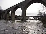 | |||
| Kirkside House Dovecot | 56°45′49″N 2°25′50″W | Category B | 16333 | | |||
| Kirkside House Including Garden Walls And Gates | 56°45′50″N 2°25′44″W | Category B | 16332 | | |||
| Kirkside House Gatepiers | 56°46′06″N 2°25′59″W | Category C(S) | 16334 | | |||
| Rock Hall Fishing Station, Including Ice House | 56°46′31″N 2°23′04″W | Category B | 45911 | |
Key
The scheme for classifying buildings in Scotland is:
- Category A: "buildings of national or international importance, either architectural or historic; or fine, little-altered examples of some particular period, style or building type."[1]
- Category B: "buildings of regional or more than local importance; or major examples of some particular period, style or building type, which may have been altered."[1]
- Category C: "buildings of local importance; lesser examples of any period, style, or building type, as originally constructed or moderately altered; and simple traditional buildings which group well with other listed buildings."[1]
In March 2016 there were 47,288 listed buildings in Scotland. Of these, 8% were Category A, and 50% were Category B, with the remaining 42% being Category C.[2]
Notes
- Sometimes known as OSGB36, the grid reference (where provided) is based on the British national grid reference system used by the Ordnance Survey.
• "Guide to National Grid". Ordnance Survey. Retrieved 2007-12-12.
• "Get-a-map". Ordnance Survey. Retrieved 2007-12-17. - Historic Environment Scotland assign a unique alphanumeric identifier to each designated site in Scotland, for listed buildings this always begins with "LB", for example "LB12345".
References
- All entries, addresses and coordinates are based on data from Historic Scotland. This data falls under the Open Government Licence
- "What is Listing?". Historic Environment Scotland. Retrieved 29 May 2018.
- Scotland's Historic Environment Audit 2016 (PDF). Historic Environment Scotland and the Built Environment Forum Scotland. pp. 15–16. Retrieved 29 May 2018.
This article is issued from Wikipedia. The text is licensed under Creative Commons - Attribution - Sharealike. Additional terms may apply for the media files.