List of listed buildings in Wick, Highland
List
| Name | Location | Date Listed | Grid Ref. [note 1] | Geo-coordinates | Notes | LB Number [note 2] | Image |
|---|---|---|---|---|---|---|---|
| 51- 55(Inclusive Nos) And 57-59 (Inclusive Nos) Argyle Square | 58°26′17″N 3°05′16″W | Category B | 42280 |  | |||
| 22, 23, 24, 25 Breadalbane Terrace | 58°26′18″N 3°05′13″W | Category C(S) | 42292 | | |||
| Coastguard Station, Old Lookout Tower | 58°25′58″N 3°04′25″W | Category B | 42306 | | |||
| 3 And 5 Depmster Street | 58°26′18″N 3°05′26″W | Category C(S) | 42307 | | |||
| High Street, Wick Old Parish Church | 58°26′39″N 3°05′44″W | Category B | 42311 | | |||
| Malcolm Street, St Joachim's Roman Catholic Church | 58°26′20″N 3°05′25″W | Category B | 42316 | | |||
| 3, 4, 5, 6 Sinclair Terrace | 58°26′21″N 3°05′29″W | Category C(S) | 42327 | | |||
| 13 Sinclair Terrace | 58°26′23″N 3°05′33″W | Category C(S) | 42330 | | |||
| 20 Sinclair Terrace | 58°26′24″N 3°05′38″W | Category C(S) | 42333 | | |||
| 25-31 (Odd Nos) Willowbank Road | 58°26′39″N 3°05′13″W | Category B | 42335 | | |||
| 1 And 2 Argyle Square | 58°26′15″N 3°05′13″W | Category B | 42267 | | |||
| 4, 5 And 6 Argyle Square | 58°26′14″N 3°05′14″W | Category B | 42268 | | |||
| 11, 12, 13, 14, 15,17,18 Argyle Square | 58°26′15″N 3°05′18″W | Category B | 42269 | | |||
| 35-41 (Inclusive Nos) And 43, 45, 46, 48 And 49 Argyle Square | 58°26′19″N 3°05′22″W | Category B | 42274 | | |||
| Whaligoe Steps And Quay | 58°20′44″N 3°09′42″W | Category B | 14070 | | |||
| Keiss Baptist Church | 58°32′40″N 3°05′59″W | Category C(S) | 14080 | | |||
| Keiss Village Braehead, Boatman's Cottage Braehead Cottage And Harbour Cottage | 58°31′54″N 3°07′01″W | Category B | 14084 | | |||
| Sibster Farm Steading | 58°27′34″N 3°09′39″W | Category A | 14088 | | |||
| Stirkoke House And Adjoining Service Range | 58°26′19″N 3°10′11″W | Category B | 14089 | | |||
| Thrumster House | 58°23′27″N 3°08′43″W | Category B | 14064 | | |||
| Harbour Quay, Storehouse Including Curing Yard Wall To Rear (Steven And Co) | 58°26′26″N 3°05′13″W | Category C(S) | 48404 | | |||
| 16, 17, 18, 19 Smith Terrace | 58°26′15″N 3°05′03″W | Category C(S) | 48409 | | |||
| Moray Street, St John The Evangelist Episcopal Church With Boundary Walls And Railings | 58°26′18″N 3°05′37″W | Category B | 44723 | | |||
| Ulbster, Byre At Ivy Cottage | 58°20′28″N 3°10′14″W | Category B | 44582 | | |||
| 8 And 9 Breadalbane Crescent Including Boundary Wall, Railings And Stables | 58°26′19″N 3°05′11″W | Category B | 42289 | | |||
| 10, 11, 12 13 Breadalbane Crescent Including Boundary Wall And Railings | 58°26′19″N 3°05′13″W | Category B | 42290 | | |||
| 14, 15, 16, 17, 18 Breadalbane Crescent | 58°26′19″N 3°05′14″W | Category B | 42291 | | |||
| 28 And 29 Breadalbane Terrace | 58°26′19″N 3°05′15″W | Category C(S) | 42295 | | |||
| 48 And 49 Breadalbane Terrace | 58°26′21″N 3°05′23″W | Category B | 42296 | | |||
| High Street, Woolworths | 58°26′34″N 3°05′29″W | Category B | 42313 | | |||
| 6 And 7 Rose Street | 58°26′24″N 3°05′15″W | Category C(S) | 42322 | | |||
| 2 Williamson Street | 58°26′24″N 3°05′17″W | Category C(S) | 42334 | | |||
| 20 And 22 Argyle Square | 58°26′15″N 3°05′20″W | Category B | 42270 | | |||
| Keiss Castle, Walled Garden Gate Lodge And Gatepiers | 58°32′21″N 3°06′30″W | Category B | 18445 | | |||
| Ackergill Tower, Garden Walls, Walled Gardens And Stable Range | 58°28′32″N 3°06′41″W | Category A | 14072 | 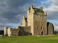 | |||
| 5 And 6 Breadalbane Terrace | 58°26′17″N 3°05′08″W | Category C(S) | 48392 | | |||
| 46 Breadalbane Terrace | 58°26′21″N 3°05′22″W | Category C(S) | 48401 | | |||
| Telford Street, (Storehouse) | 58°26′26″N 3°05′20″W | Category C(S) | 48410 | | |||
| 62 And 63 Argyle Square | 58°26′16″N 3°05′12″W | Category B | 42283 | | |||
| 65 Argyle Square And 1 Grant Street | 58°26′16″N 3°05′12″W | Category B | 42284 | | |||
| 4 And 6 Breadalbane Crescent Including Boundary Wall, Railings And Stables | 58°26′19″N 3°05′10″W | Category B | 42288 | | |||
| Bridge Street, Town Hall | 58°26′31″N 3°05′35″W | Category B | 42299 | | |||
| Bridge Street. Bridge Street Parish Church | 58°26′32″N 3°05′36″W | Category B | 42301 | | |||
| Bridge Street, Bank Of Scotland | 58°26′32″N 3°05′35″W | Category B | 42303 | | |||
| 26 Broadhaven (W Mcdonald) | 58°26′47″N 3°03′48″W | Category B | 42304 | | |||
| Harbour Place, The Round House | 58°26′22″N 3°05′10″W | Category B | 42310 | | |||
| High Street, Graveyard With Remains Of Old St Fergus Church And Enclosing Walls | 58°26′38″N 3°05′41″W | Category B | 42312 | | |||
| 30, 31, 33 Argyle Square | 58°26′18″N 3°05′25″W | Category B | 42272 | | |||
| Wester Bridge Of Wester Over Wester River | 58°30′40″N 3°08′59″W | Category B | 14068 | | |||
| Ackergill Tower Dovecotes | 58°28′28″N 3°06′40″W | Category B | 14073 | | |||
| Hempriggs House And Stable / Carriage House | 58°24′31″N 3°06′21″W | Category B | 14079 | | |||
| Keiss Village Scaraben | 58°32′03″N 3°07′25″W | Category B | 14083 | | |||
| Noss Head Lighthouse Keepers' Houses And Offices | 58°28′44″N 3°03′04″W | Category A | 14087 | | |||
| 31 Breadalbane Terrace | 58°26′19″N 3°05′16″W | Category C(S) | 48396 | | |||
| 11 Malcolm Street | 58°26′19″N 3°05′27″W | Category C(S) | 48406 | | |||
| 1 Breadalbane Crescent Including Rear Garden Wall | 58°26′18″N 3°05′08″W | Category B | 42287 | | |||
| 26 And 27 Breadalbane Terrace | 58°26′19″N 3°05′15″W | Category C(S) | 42294 | | |||
| Bridge Street, Royal Bank Of Scotland | 58°26′30″N 3°05′36″W | Category B | 42298 | | |||
| Bridge Street, Clydesdale Bank | 58°26′33″N 3°05′33″W | Category B | 42302 | | |||
| 7 Church Street. Kirkhill | 58°26′39″N 3°05′39″W | Category C(S) | 42305 | | |||
| Dempster Street, Wick Central Church (Church Of Scotland) | 58°26′16″N 3°05′25″W | Category B | 42308 | | |||
| Hillhead Farm East And West Kilns And Abutting Ranges Of Farm Buildings | 58°26′49″N 3°04′27″W | Category B | 42315 | | |||
| Market Place, High Street Post Office | 58°26′32″N 3°05′27″W | Category B | 42320 | | |||
| 7, 8, 9, 10 Sinclair Terrace | 58°26′22″N 3°05′31″W | Category C(S) | 42328 | | |||
| 18 Sinclair Terrace | 58°26′24″N 3°05′37″W | Category B | 42332 | | |||
| Ulbster, Ivy Cottage And Garden Walls | 58°20′28″N 3°10′14″W | Category C(S) | 19479 | | |||
| Ulbster Mr James Sinclair's House And Steading | 58°21′16″N 3°09′30″W | Category C(S) | 14067 | | |||
| Whaligoe Former Curing Yard And Dwelling | 58°20′46″N 3°09′46″W | Category B | 14069 | | |||
| Keiss Village Church Of Scotland | 58°31′58″N 3°07′15″W | Category B | 14082 | 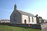 | |||
| Ulbster Sinclair Mausoleum And St Martin's Burial Ground With Gate Piers | 58°21′36″N 3°08′13″W | Category B | 14066 | | |||
| 42 Breadalbane Terrace | 58°26′20″N 3°05′21″W | Category C(S) | 48400 | | |||
| 15 And 16 Sinclair Terrace | 58°26′23″N 3°05′35″W | Category B | 48408 | | |||
| Staxigoe Grain Store | 58°27′21″N 3°03′22″W | Category B | 49297 | | |||
| Harbour Quay, Old Fish Market | 58°26′18″N 3°05′05″W | Category C(S) | 44955 | | |||
| High Street, Wick Old Parish Church Churchyard, Dunbar Memorial | 58°26′38″N 3°05′41″W | Category A | 44956 | | |||
| Bridge Street, Bridge Over Wick River | 58°26′30″N 3°05′38″W | Category B | 42297 | | |||
| 8 And 10 Dempster Street | 58°26′19″N 3°05′26″W | Category C(S) | 42319 | | |||
| Shore Lane, Mount Hooley And Gatepiers | 58°26′36″N 3°05′20″W | Category B | 42323 | | |||
| 1 And 2 Sinclair Terrace | 58°26′21″N 3°05′28″W | Category C(S) | 42326 | | |||
| Ackergill Shore, Former Life Boat House | 58°28′26″N 3°06′04″W | Category B | 14075 | | |||
| Haster, Bridge Of Haster Over Achairn Burn | 58°26′38″N 3°09′13″W | Category B | 14077 | | |||
| Keiss Harbour And Warehouse | 58°31′54″N 3°06′58″W | Category A | 14085 | | |||
| 1, 2 And 3 Breadalbane Terrace | 58°26′16″N 3°05′08″W | Category C(S) | 48391 | | |||
| 12 And 13 Breadalbane Terrace | 58°26′17″N 3°05′09″W | Category C(S) | 48393 | | |||
| 17, 18, 19 Breadalbane Terrace | 58°26′18″N 3°05′11″W | Category C(S) | 48395 | | |||
| 41 Breadalbane Terrace | 58°26′20″N 3°05′20″W | Category C(S) | 48399 | | |||
| 18 Bank Row | 58°26′23″N 3°05′18″W | Category C(S) | 42285 | | |||
| Bridge Street, Sheriff Court | 58°26′31″N 3°05′34″W | Category B | 42300 | | |||
| 7 And 9 Malcolm Street | 58°26′20″N 3°05′26″W | Category C(S) | 42318 | | |||
| Wick Railway Station | 58°26′30″N 3°05′48″W | Category B | 42321 | | |||
| Sinclair Terrace, Wick Martyrs' Free Church | 58°26′20″N 3°05′27″W | Category B | 42325 | | |||
| Whaligoe Mill | 58°20′51″N 3°09′40″W | Category B | 14071 | | |||
| Keiss Baptist Manse | 58°32′40″N 3°06′01″W | Category C(S) | 14081 | | |||
| Tannach Mains | 58°24′29″N 3°09′29″W | Category B | 14090 | | |||
| Bank Row, The Black Stairs | 58°26′22″N 3°05′14″W | Category C(S) | 48390 | | |||
| 15 Breadalbane Terrace | 58°26′18″N 3°05′11″W | Category C(S) | 48394 | | |||
| 42 Union Street, (North Of Scotland Newspapers) | 58°26′26″N 3°05′39″W | Category B | 48411 | | |||
| Wick Harbour, South Pier Lighthouse And North Pier Lighthouse | 58°26′22″N 3°04′54″W | Category B | 42309 | | |||
| 17 Sinclair Terrace | 58°26′23″N 3°05′36″W | Category B | 42331 | | |||
| Rutherford, Undertaker Off Argyle Square | 58°26′15″N 3°05′21″W | Category C(S) | 42271 | | |||
| Bilbster House | 58°27′45″N 3°13′57″W | Category C(S) | 14076 | | |||
| Keiss Harbour Ice-House | 58°31′55″N 3°06′54″W | Category C(S) | 14086 | | |||
| 37 And 38 Breadalbane Terrace | 58°26′20″N 3°05′19″W | Category C(S) | 48398 | | |||
| 47 Breadalbane Terrace | 58°26′21″N 3°05′22″W | Category C(S) | 48403 | | |||
| Keiss Harbour Bothy | 58°31′55″N 3°07′00″W | Category B | 43519 | | |||
| 19 - 27 (Odd) Bank Row (Wick Heritage Centre) | 58°26′23″N 3°05′20″W | Category A | 42286 | 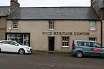 | |||
| High Street, D R Simpson, Ironmonger | 58°26′34″N 3°05′27″W | Category C(S) | 42314 | | |||
| Malcolm Street, Roman Catholic Convent | 58°26′20″N 3°05′25″W | Category C(S) | 42317 | | |||
| Sinclair Terrace, Carnegie Public Library | 58°26′25″N 3°05′38″W | Category B | 42324 | | |||
| Ackergill Mains | 58°28′11″N 3°06′41″W | Category B | 14074 | | |||
| Hempriggs, Cottage Opposite Main Entrance Drive, Facing A9 Road | 58°24′27″N 3°06′49″W | Category C(S) | 14078 | | |||
| Ulbster Mains Of Ulbster | 58°21′42″N 3°08′14″W | Category C(S) | 14065 | | |||
| 32 Breadalbane Terrace | 58°26′19″N 3°05′17″W | Category C(S) | 48397 | | |||
| High Street, Stafford Place, Wick Council Offices | 58°26′33″N 3°05′29″W | Category C(S) | 48834 | | |||
| Argyle Square, Pulteneytown Parish Church | 58°26′15″N 3°05′22″W | Category C(S) | 49693 | | |||
| Thrumster, South Yarrows Croft House, Byres And Boundary Walls | 58°22′22″N 3°11′12″W | Category C(S) | 50835 | |
Key
The scheme for classifying buildings in Scotland is:
- Category A: "buildings of national or international importance, either architectural or historic; or fine, little-altered examples of some particular period, style or building type."[1]
- Category B: "buildings of regional or more than local importance; or major examples of some particular period, style or building type, which may have been altered."[1]
- Category C: "buildings of local importance; lesser examples of any period, style, or building type, as originally constructed or moderately altered; and simple traditional buildings which group well with other listed buildings."[1]
In March 2016 there were 47,288 listed buildings in Scotland. Of these, 8% were Category A, and 50% were Category B, with the remaining 42% being Category C.[2]
See also
Notes
- Sometimes known as OSGB36, the grid reference (where provided) is based on the British national grid reference system used by the Ordnance Survey.
• "Guide to National Grid". Ordnance Survey. Retrieved 12 December 2007.
• "Get-a-map". Ordnance Survey. Retrieved 17 December 2007. - Historic Environment Scotland assign a unique alphanumeric identifier to each designated site in Scotland, for listed buildings this always begins with "LB", for example "LB12345".
References
- All entries, addresses and coordinates are based on data from Historic Scotland. This data falls under the Open Government Licence
- "What is Listing?". Historic Environment Scotland. Retrieved 29 May 2018.
- Scotland's Historic Environment Audit 2016 (PDF). Historic Environment Scotland and the Built Environment Forum Scotland. pp. 15–16. Retrieved 29 May 2018.
This article is issued from Wikipedia. The text is licensed under Creative Commons - Attribution - Sharealike. Additional terms may apply for the media files.