List of protected heritage sites in Étalle, Belgium
This table shows an overview of the protected heritage sites in the Walloon town Étalle, Belgium. This list is part of Belgium's national heritage.
| Object |
Year/architect |
Town/section |
Address |
Coordinates |
Number? |
Image |
|---|---|---|---|---|---|---|
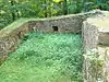
| Ancient fortified ruins of the refuge and covered halls of the old ironworks from the 17th century and the ensemble of the listed buildings and the immediate vicinity of the former Roman camp (nl) (fr) |
Etalle | 49.630729°N 5.594953°E |
85009-CLT-0001-01 Info |
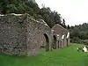 Oude versterkte uitwijkplaats en ruïnes van de overdekte hallen van de oude smederijen uit de 17e eeuw en het ensemble van de genoemde gebouwen en de directe omgeving van het voormalige Romeinse kamp | ||
| St. Martin's Church (nl) (fr) |
Etalle | 49.699785°N 5.561089°E |
85009-CLT-0002-01 Info |
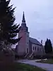 Kerk Saint-Martin | ||
| Washing place near the church Saint-Martin (nl) (fr) |
Etalle | rue Saint-Martin | 49.699717°N 5.560804°E |
85009-CLT-0003-01 Info |
||
| pump (nl) (fr) |
Etalle | rue du Marais | 49.671532°N 5.564859°E |
85009-CLT-0004-01 Info |
||
| pump (nl) (fr) |
Etalle | Place Communale, Etalle | 49.673784°N 5.563959°E |
85009-CLT-0005-01 Info |
||
| pump (nl) (fr) |
Etalle | chaussée Romaine | 49.669677°N 5.563839°E |
85009-CLT-0006-01 Info |
||
| Washing place (nl) (fr) |
Etalle | route de Mortinsart | 49.704218°N 5.585335°E |
85009-CLT-0007-01 Info |
||
| Linden tree near the church (nl) (fr) |
Etalle | place Saint-Michel | 49.653157°N 5.651151°E |
85009-CLT-0008-01 Info |
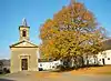 Linde nabij de kerk | |
| Avenue with 36 lime trees at the exit of Chantemelle (nl) (fr) |
Etalle | 49.649811°N 5.651409°E |
85009-CLT-0009-01 Info |
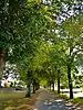 Laan met 36 lindebomen bij de uitgang van Chantemelle | ||
| The heraldic shield with the coat of arms of Semois (nl) (fr) |
Etalle | 49.687928°N 5.551508°E |
85009-CLT-0010-01 Info |
|||
| Marsh called "du Landbrough" and environment (nl) (fr) |
Etalle | 49.654740°N 5.683657°E |
85009-CLT-0011-01 Info |
|||
| Ensemble of the archaeological site of the old ironworks of Buzenol (nl) (fr) |
Etalle | 49.630322°N 5.591735°E |
85009-PEX-0001-01 Info |
 Ensemble van de archeologische site van Buzenol waaronder de oude ijzergieterij | ||
| Marsh called "du Landbrough" (nl) (fr) |
Etalle | 49.654740°N 5.683657°E |
85009-PEX-0002-01 Info |
See also
- List of protected heritage sites in Luxembourg (Belgium)
- Étalle, Belgium
| Wikimedia Commons has media related to Cultural heritage monuments in Étalle, Belgium. |
References
- Belgian heritage register: Direction générale opérationnelle - Aménagement du territoire, Logement, Patrimoine et Energie (DG4)
- www.dglive.be
This article is issued from Wikipedia. The text is licensed under Creative Commons - Attribution - Sharealike. Additional terms may apply for the media files.