List of protected heritage sites in Braine-le-Château
This table shows an overview of the protected heritage sites in the Walloon town Braine-le-Château. This list is part of Belgium's national heritage.
| Object |
Year/architect |
Town/section |
Address |
Coordinates |
Number? |
Image |
|---|---|---|---|---|---|---|
| Bailiff's house except outbuildings (nl) (fr) |
Braine-le-Château | Grand-Place, n°20 | 50.682173°N 4.266177°E |
25015-CLT-0002-01 Info |
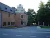 Baljuwhuis, uitgezonderd bijgebouwen | |
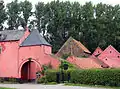
| Castle of the Counts of Hornes (Robiano) (nl) (fr) |
Braine-le-Château | 50.683452°N 4.266608°E |
25015-CLT-0004-01 Info |
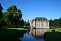 Kasteel van de graven van Hornes (Robiano) | ||
| Area around castle cemetery wall, classified as a monument by Royal Decree of 17 March 1949, including the wall of the road rue des Comtes the Robiano, and the wall of the cemetery (nl) (fr) |
Braine-le-Château | 50.683290°N 4.265276°E |
25015-CLT-0005-01 Info |
|||
| Pilori (nl) (fr) |
1521 | Braine-le-Château | Grand Place | 50.681836°N 4.266535°E |
25015-CLT-0006-01 Info |
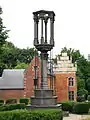 Schandpaal |
| Banal mill with its wheel, enclave in the park of the castle of the Counts of Hornes (nl) (fr) |
Braine-le-Château | Rue des Comtes de Robiano 4 | 50.683771°N 4.264747°E |
25015-CLT-0007-01 Info |
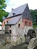 Seigneuriale molen met zijn rad, enclave in het park van het kasteel van de graven van Hornes | |
| Chapel of Notre-Dame au Bois and environment (nl) (fr) |
1740 | Braine-le-Château | 50.673307°N 4.264328°E |
25015-CLT-0009-01 Info |
||
| Portico of the entrance of the cemetery and the adjacent wall of the cemetery and the property of "Comte Cornet de Ways Ruart" (nl) (fr) |
Braine-le-Château | 50.682466°N 4.266757°E |
25015-CLT-0010-01 Info |
|||
| Chapel of Sainte-Croix and its environment (nl) (fr) |
Braine-le-Château | 50.687742°N 4.262730°E |
25015-CLT-0011-01 Info |
|||
| Farmhouse Rose of Binchefort (facades and roofs) and its surroundings (nl) (fr) |
Braine-le-Château | 50.682014°N 4.258355°E |
25015-CLT-0012-01 Info |
 Boerderij Rose of Binchefort (gevels en daken) en diens omgeving | ||
| Medieval site southwest of the place called "Les Monts" (nl) (fr) |
Braine-le-Château | 50.686050°N 4.259049°E |
25015-CLT-0013-01 Info |
|||
| Rectory (facades and roofs), church, cemetery and square (nl) (fr) |
Wauthier-Braine Braine-le-Château | 50.680614°N 4.299065°E |
25015-CLT-0014-01 Info |
|||
| Forest Haumont, except for the two open spots around the house built on lot 75 b and the other in plots 4 r 5 and 4 s 5 (nl) (fr) |
Braine-le-Château | 50.679091°N 4.314161°E |
25015-CLT-0015-01 Info |
See also
- List of protected heritage sites in Walloon-Brabant
- Braine-le-Château
| Wikimedia Commons has media related to Cultural heritage monuments in Braine-le-Château. |
References
- Belgian heritage register: Direction générale opérationnelle - Aménagement du territoire, Logement, Patrimoine et Energie (DG4)
- www.dglive.be
This article is issued from Wikipedia. The text is licensed under Creative Commons - Attribution - Sharealike. Additional terms may apply for the media files.