List of protected heritage sites in Ham-sur-Heure-Nalinnes
This table shows an overview of the protected heritage sites in the Walloon town Ham-sur-Heure-Nalinnes. This list is part of Belgium's national heritage.
| Object |
Year/architect |
Town/section |
Address |
Coordinates |
Number? |
Image |
|---|---|---|---|---|---|---|
| Castle of Ham-sur-Heure (nl) (fr) |
Ham-sur-Heure-Nalinnes | 50.321672°N 4.392615°E |
56086-CLT-0001-01 Info |
.JPG.webp) Kasteel van Ham-sur-Heure | ||
| Chapel of Saint-Roch (nl) (fr) |
Ham-sur-Heure-Nalinnes | Ham-sur-Heure | 50.321686°N 4.387806°E |
56086-CLT-0003-01 Info |
||
| Church of Sainte Vierge (nl) (fr) |
Ham-sur-Heure-Nalinnes | Nalinnes | 50.324819°N 4.444998°E |
56086-CLT-0004-01 Info |
 Kerk de la Sainte-Vierge | |
| Drève de la Ferree (nl) (fr) |
Ham-sur-Heure-Nalinnes | Nalinnes | 50.345457°N 4.455939°E |
56086-CLT-0005-01 Info |
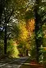 Drève de la Ferrée | |
| fortified house (nl) (fr) |
Ham-sur-Heure-Nalinnes | Nalinnes | 50.324416°N 4.444936°E |
56086-CLT-0006-01 Info |
||
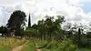
| Forest "Bois de la Ferree" (nl) (fr) |
Ham-sur-Heure-Nalinnes | Ham-sur-Heure-Nalinnes | 50.355110°N 4.463470°E |
56086-CLT-0007-01 Info |
||
| Totality of 17th-century tower of the castle de la Pasture, and conservation of the castle, the farm, the park and the land occupied by the farm and its surroundings (nl) (fr) |
Ham-sur-Heure-Nalinnes | Chemin Sainte-Barbe, te Marbaix-la-Tour | 50.331210°N 4.376152°E |
56086-CLT-0008-01 Info |
See also
- List of protected heritage sites in Hainaut (province)
- Ham-sur-Heure-Nalinnes
| Wikimedia Commons has media related to Cultural heritage monuments in Ham-sur-Heure-Nalinnes. |
References
- Belgian heritage register: Direction générale opérationnelle - Aménagement du territoire, Logement, Patrimoine et Energie (DG4)
- www.dglive.be
This article is issued from Wikipedia. The text is licensed under Creative Commons - Attribution - Sharealike. Additional terms may apply for the media files.