List of protected heritage sites in Ottignies-Louvain-la-Neuve
This table shows an overview of the protected heritage sites in the Walloon town Ottignies-Louvain-la-Neuve. This list is part of Belgium's national heritage.
| Object |
Year/architect |
Town/section |
Address |
Coordinates |
Number? |
Image |
|---|---|---|---|---|---|---|
| Ensemble of the church of Saint-Remy, the rectory and the castle of Ottignies (nl) (fr) |
Ottignies-Louvain-la-Neuve | 50.666102°N 4.565912°E |
25121-CLT-0001-01 Info |
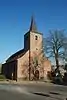 Ensemble van de kerk Saint-Rémy, de pastorie en het kasteel van Ottignies | ||
| Tower Moriensart (nl) (fr) |
Ottignies-Louvain-la-Neuve | 50.665872°N 4.506784°E |
25121-CLT-0004-01 Info |
 Toren van Moriensart | ||
| The choir, the transept, the nave and the crypt of the church of Notre-Dame (nl) (fr) |
Ottignies-Louvain-la-Neuve | 50.660990°N 4.564919°E |
25121-CLT-0007-01 Info |
 Het koor, het transept, het schip en de crypte van de kerk Notre-Dame | ||
| Church of Notre Dame (including the choir, the transept, the nave and the crypt classified as a monument by Royal Decree of 29 May 1952, as amended by Royal Decree of 5 March 1969), in its entirety, except for the porch (nl) (fr) |
Ottignies-Louvain-la-Neuve | 50.660984°N 4.564679°E |
25121-CLT-0008-01 Info |
 Kerk Notre-Dame (inclusief het koor, het transept, het schip en de crypte geclassificeerd als een monument bij koninklijk besluit van 29 mei 1952, aangepast bij Koninklijk Besluit van 5 maart 1969), in zijn geheel, met uitzondering van de veranda | ||
| The remains of the late Baron de Lambermont and surrounding area (nl) (fr) |
Ottignies-Louvain-la-Neuve | 50.688762°N 4.544333°E |
25121-CLT-0010-01 Info |
 De overblijfselen van wijlen Baron de Lambermont en de omliggende terreinen | ||
| Domaine Saint-Jean des Bois (nl) (fr) |
Ottignies-Louvain-la-Neuve | 50.681395°N 4.580652°E |
25121-CLT-0011-01 Info |
|||
| Extension of the classification: domain of Saint-Jean des Bois (nl) (fr) |
Ottignies-Louvain-la-Neuve | 50.679005°N 4.584128°E |
25121-CLT-0012-01 Info |
|||
| Old farm Douire: facades, roofs and basement (nl) (fr) |
Ottignies-Louvain-la-Neuve | rue des Combattants, n°2 (M) et terrains environnants (S) | 50.663102°N 4.565606°E |
25121-CLT-0014-01 Info |
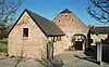 Oude boerderij van Douire: gevels, daken en kelder | |
| Farm of Biéreau: facades, roofs and cladding of the south wing and the main building of the farm, and the whole barn, with the exception of stables in the courtyard (nl) (fr) |
Ottignies-Louvain-la-Neuve | 50.665777°N 4.617454°E |
25121-CLT-0015-01 Info |
|||
| Forests of Lauzelle (nl) (fr) |
Ottignies-Louvain-la-Neuve | 50.681443°N 4.614268°E |
25121-CLT-0016-01 Info |
See also
- List of protected heritage sites in Walloon-Brabant
- Ottignies-Louvain-la-Neuve
| Wikimedia Commons has media related to Cultural heritage monuments in Ottignies-Louvain-la-Neuve. |
References
- Belgian heritage register: Direction générale opérationnelle - Aménagement du territoire, Logement, Patrimoine et Energie (DG4)
- www.dglive.be
This article is issued from Wikipedia. The text is licensed under Creative Commons - Attribution - Sharealike. Additional terms may apply for the media files.