List of protected heritage sites in Ramillies, Belgium
This table shows an overview of the protected heritage sites in the Walloon town Ramillies, Belgium. This list is part of Belgium's national heritage.
| Object |
Year/architect |
Town/section |
Address |
Coordinates |
Number? |
Image |
|---|---|---|---|---|---|---|
| Tumulus of Hottomont and surrounding area (nl) (fr) |
Ramillies | 50.622708°N 4.891027°E |
25122-CLT-0003-01 Info |
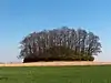 Tumulus van Hottomont en omliggende terreinen | ||
| Chapel of Saint-Feuillen except the sacristy (nl) (fr) |
Ramillies | rue de la Gare d'Hédenge et alentours | 50.673845°N 4.905753°E |
25122-CLT-0004-01 Info |
 Kapel Saint-Feuillen, uitgezonderd de sacristie | |
| Presbytery Church of Saint-Hubert and outbuildings: facades and roofs, and environment (nl) (fr) |
Ramillies | rue du Wayaux (S) | 50.636329°N 4.915740°E |
25122-CLT-0005-01 Info |
||
| Presbytery: facades and roofs, and surrounding wall (nl) (fr) |
Ramillies | rue de la Place (M) et alentours (S) | 50.663367°N 4.925040°E |
25122-CLT-0006-01 Info |
||
| Rectory of the church of Saint-symphorien and construction: walls and roofs (nl) (fr) |
Ramillies | rue Louis Delvaux (M) et alentours (S) | 50.643862°N 4.861066°E |
25122-CLT-0007-01 Info |
||
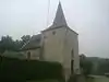
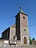
| Notre Dame Church and surroundings (nl) (fr) |
Ramillies | 50.663416°N 4.925578°E |
25122-CLT-0008-01 Info |
 Kerk Notre-Dame en omgeving | ||
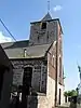
| Church of Saint-Jean-Baptiste (nl) (fr) |
Ramillies | 50.692198°N 4.892477°E |
25122-CLT-0009-01 Info |
 Kerk Saint-Jean-Baptiste | ||
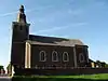
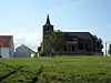
| Church of Saint-André and the cemetery wall and its surroundings (nl) (fr) |
Ramillies | 50.654902°N 4.863665°E |
25122-CLT-0010-01 Info |
 Kerk Saint-André en de kerkhofmuur en diens omgeving | ||
| Church of Saint-Remy and environment (nl) (fr) |
Ramillies | 50.646967°N 4.880574°E |
25122-CLT-0011-01 Info |
 Kerk Saint-Remy en omgeving | ||
| Baptismal font of Molembais (nl) (fr) |
Ramillies | 50.693261°N 4.906369°E |
25122-CLT-0012-01 Info |
|||
| Church of Notre-Dame du Rosaire (nl) (fr) |
Ramillies | 50.668096°N 4.873550°E |
25122-CLT-0016-01 Info |
 Kerk Notre-Dame du Rosaire | ||
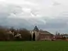
| Facades, roofs and cladding of all parts and the totality of the barn of the farm of Ramie and the surrounding area (nl) (fr) |
Ramillies | 50.679696°N 4.852983°E |
25122-CLT-0018-01 Info |
|||
| The presbytery dating from the 17th century (nl) (fr) |
Ramillies | 50.668763°N 4.873869°E |
25122-CLT-0019-01 Info |
|||
| Tumulus of Hottomont, archaeological site (nl) (fr) |
Ramillies | Grand-Rosière | 50.622708°N 4.891027°E |
25122-PEX-0001-01 Info |
Tumulus van Hottomont, archeologische site | |
| The facades and roofs of the "ancien regime" buildings of the courtyard of the farm of Ramie (nl) (fr) |
Ramillies | 50.679696°N 4.852983°E |
25122-PEX-0002-01 Info |
See also
- List of protected heritage sites in Walloon-Brabant
- Ramillies, Belgium
| Wikimedia Commons has media related to Cultural heritage monuments in Ramillies, Belgium. |
References
- Belgian heritage register: Direction générale opérationnelle - Aménagement du territoire, Logement, Patrimoine et Energie (DG4)
- www.dglive.be
This article is issued from Wikipedia. The text is licensed under Creative Commons - Attribution - Sharealike. Additional terms may apply for the media files.