List of protected heritage sites in Theux
This table shows an overview of the protected heritage sites in the Walloon town Theux. This list is part of Belgium's national heritage.
| Object |
Year/architect |
Town/section |
Address |
Coordinates |
Number? |
Image |
|---|---|---|---|---|---|---|
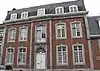
| House "Maison de Limbourg" (nl) (fr) |
Theux | rue de la Chaussée, n°35 | 50.534734°N 5.812085°E |
63076-CLT-0001-01 Info |
 Huis Maison de Limbourg | |
| Haldes calaminaires of Rocheux (nl) (fr) |
Theux | 50.539629°N 5.829100°E |
63076-CLT-0003-01 Info |
|||
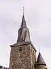
| Church of Saints-Hermès et Alexandre and the wall around the cemetery, two portals and their lattice work (nl) (fr) |
Theux | 50.534049°N 5.811159°E |
63076-CLT-0004-01 Info |
 Kerk Saints-Hermès-et-Alexandre en de muur rond het kerkhof, twee portalen en hun roosterwerk | ||
| Factory named pavillon Felix Bernard (nl) (fr) |
Theux | la Heid de Spa, promenade Reikem | 50.490649°N 5.841382°E |
63076-CLT-0005-01 Info |
||
| House (nl) (fr) |
Theux | rue Bouxherie n°1 | 50.532123°N 5.816231°E |
63076-CLT-0006-01 Info |
||
| House: walls and roofs and part of the old smithy from the 17th century (nl) (fr) |
Theux | rue Bouxherie, n°2 | 50.531952°N 5.816464°E |
63076-CLT-0007-01 Info |
||
| Building: front and rear facades, roofs and gable (nl) (fr) |
Theux | rue de la Chaussée n°46 | 50.534975°N 5.811978°E |
63076-CLT-0008-01 Info |
||
| Building: front and rear facades, roofs (nl) (fr) |
Theux | rue de la Chaussée n°44 | 50.534975°N 5.812050°E |
63076-CLT-0009-01 Info |
||
| Hospice Sainte-Josephine: main facade, front roof slope, except garage on the right (nl) (fr) |
Theux | rue de la Chaussée n°s 25-27 | 50.534692°N 5.812556°E |
63076-CLT-0010-01 Info |
 Hospice Sainte-Joséphine: hoofdgevel, dakhelling voorzijde, uitgezonderd garage aan de rechterzijde | |
| House: main facade, front roof, gabled right parts in broken stonework higher than adjacent building (nl) (fr) |
Theux | place du Perron n°10 | 50.535326°N 5.813532°E |
63076-CLT-0011-01 Info |
||
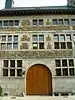
| House of Bailli: facades and roofs of the main building, two towers (nl) (fr) |
Theux | n°s 2-4, Marché | 50.527875°N 5.820563°E |
63076-CLT-0012-01 Info |
.JPG.webp) Huis van Bailli: gevels en daken van het hoofdgebouw, twee torens | |
| House of Boverie: facades and roofs including extensions (nl) (fr) |
Theux | rue Waillot n°5 | 50.533663°N 5.810021°E |
63076-CLT-0013-01 Info |
||
| Chapel du Bon Air (nl) (fr) |
Theux | 50.479708°N 5.778782°E |
63076-CLT-0014-01 Info |
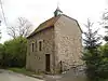 Kapel du Bon Air | ||
| House facades, roofs and left side gate (nl) (fr) |
Theux | rue Hovémont n°80 | 50.532486°N 5.814826°E |
63076-CLT-0015-01 Info |
||
| Presbytery: facades and roofs, porch and parts of the walled square (nl) (fr) |
Theux | rue de la Chaussée, n°50 | 50.535249°N 5.811707°E |
63076-CLT-0016-01 Info |
 Pastorie: gevels en daken, portaal en delen van demuur aan het plein | |
| Town hall (nl) (fr) |
Theux | rue de la Chaussée n°10 | 50.534931°N 5.813305°E |
63076-CLT-0017-01 Info |
 Raadhuis | |
| House Del Heid: facades and roofs (nl) (fr) |
Theux | rue de la Chaussée n°31 | 50.534756°N 5.812293°E |
63076-CLT-0018-01 Info |
 Huis Del Heid: gevels en daken | |
| House: main facade and front roof slope (nl) (fr) |
Theux | place du Perron n°12 | 50.535403°N 5.813478°E |
63076-CLT-0019-01 Info |
 Huis: hoofdgevel en voorzijde dakhelling | |
| House called "maison Lebrun" (nl) (fr) |
Theux | place du Perron n°s 2-4 | 50.535068°N 5.813444°E |
63076-CLT-0020-01 Info |
.JPG.webp) Huis genaamd "maison Lebrun" | |
| Charmille du Haut-Marais in the hamlet of Hautregard and the ensemble of the arbor and its surroundings (nl) (fr) |
Theux | 50.471214°N 5.777511°E |
63076-CLT-0021-01 Info |
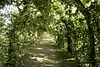 Charmille du Haut-Marais in het gehucht van Hautregard en het ensemble van het prieel en diens omgeving | ||
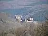
| Ruins of the castle-fortress of Franchimont: 14th, 15th and 16th centuries (nl) (fr) |
Theux | 50.527673°N 5.824241°E |
63076-CLT-0022-01 Info |
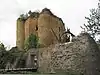 Ruïnes van het kasteel-fort van Franchimont: 14e, 15e en 16e eeuw | ||
| Organs of the church Saint-Roch (nl) (fr) |
Theux | 50.556688°N 5.898728°E |
63076-CLT-0023-01 Info |
|||
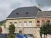
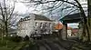
| Old bridge of Polleur (nl) (fr) |
Theux | rue R. Bordure | 50.538289°N 5.881694°E |
63076-CLT-0024-01 Info |
.jpg.webp) Oude brug van Polleur | |
| Farm Chapelle: tower and ensemble of the farm, chapel of Bon Air and surrounding areas (nl) (fr) |
Theux | n°337 | 50.480326°N 5.778162°E |
63076-CLT-0025-01 Info |
||
| Castle Hautregard: facades and roofs, except the southwest facade of the 19th century (nl) (fr) |
Theux | 50.485382°N 5.770551°E |
63076-CLT-0026-01 Info |
 Kasteel van Hautregard: gevels en daken, uitgezonderd de zuidwestgevel uit de 19e eeuw | ||
| Farm of Haye: facades and roofs, surrounding wall, porch, two chimneys of the early 17th century, except for the recent additions (nl) (fr) |
Theux | 50.517570°N 5.799477°E |
63076-CLT-0027-01 Info |
 Boerderij van Haye: gevels en daken, omliggende muur, portiek, twee schoorstenen van de vroege 17e eeuw, uitgezonderd de recente toevoegingen | ||
| Extending the classification of the site of Haldes calaminaires of Rocheux (nl) (fr) |
Theux | 50.541580°N 5.831613°E |
63076-CLT-0028-01 Info |
|||
| Church tower and spire of Saint-Jacques, now Notre Dame (nl) (fr) |
Theux | 50.539116°N 5.881110°E |
63076-CLT-0029-01 Info |
 Toren en spits van kerk Saint-Jacques, tegenwoordig kerk Notre-Dame | ||
| Thier du Gibet (nl) (fr) |
Theux | 50.541384°N 5.818494°E |
63076-CLT-0031-01 Info |
|||
| Group of remarkable trees (nl) (fr) |
Theux | Basse Desnié | 50.461128°N 5.810130°E |
63076-CLT-0032-01 Info |
.jpg.webp) Groep van opmerkelijke bomen | |
| Ensemble of the chapel and its surroundings Fyon (nl) (fr) |
Theux | rue Rittweger n°228 | 50.548955°N 5.807645°E |
63076-CLT-0033-01 Info |
||
| One-hundred-year-old walnut tree on the farm Marquisat (nl) (fr) |
Theux | 50.532851°N 5.839552°E |
63076-CLT-0034-01 Info |
|||
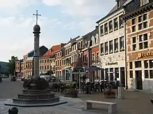
| Perron (nl) (fr) |
Theux | place du Perron | 50.535333°N 5.813262°E |
63076-CLT-0035-01 Info |
.JPG.webp) Bordes | |
| Eight border posts of the marquisate of Franchimont in the country of Liege and the settlement of Louveigné, municipality of Stavelot (nl) (fr) |
Theux | 50.528216°N 5.758792°E |
63076-CLT-0036-01 Info |
|||
| Protection of the donjon and the 16th-century ruins of the castle-fortress of Franchimont (nl) (fr) |
Theux | 50.527673°N 5.824241°E |
63076-PEX-0001-01 Info |
 Bescherming van het donjon en de 16e-eeuwse ruïnes van het kasteel-fort van Franchimont |
See also
- List of protected heritage sites in Liège (province)
| Wikimedia Commons has media related to Cultural heritage monuments in Theux. |
References
- Belgian heritage register: Direction générale opérationnelle - Aménagement du territoire, Logement, Patrimoine et Energie (DG4)
- www.dglive.be