Little Cut
The Little Cut, also known as the Rain Hall Rock Branch or the Rain Hall Rock Canal, was a short canal connecting the Leeds and Liverpool Canal at Barnoldswick to the nearby Rain Hall Rock limestone quarry. The canal ran north-east for 950 yards (870 m) through farmland and a deep cutting—including two tunnels—before terminating in a small basin.
| The Little Cut | |
|---|---|
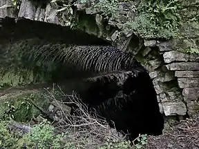
 The northwest entrance to the Barnsay Tunnel | |
| Location | Barnoldswick, Lancashire |
| Country | United Kingdom |
| Coordinates | 53.9188°N 2.1724°W |
| Specifications | |
| Length | 0.53 miles (0.85 km) |
| Locks | 0 |
| Status | Infilled |
| History | |
| Original owner | Leeds and Liverpool Canal Company |
| Construction began | 1796 |
| Date extended | 1799, 1828 |
| Date closed | c. 1918 |
| Geography | |
| Branch of | Leeds and Liverpool Canal |
Canal
| The Little Cut | ||||||||||||||||||||||||||||||||||||||||||||||||||||||||||||||||||||||||||||||||||||
|---|---|---|---|---|---|---|---|---|---|---|---|---|---|---|---|---|---|---|---|---|---|---|---|---|---|---|---|---|---|---|---|---|---|---|---|---|---|---|---|---|---|---|---|---|---|---|---|---|---|---|---|---|---|---|---|---|---|---|---|---|---|---|---|---|---|---|---|---|---|---|---|---|---|---|---|---|---|---|---|---|---|---|---|---|
| ||||||||||||||||||||||||||||||||||||||||||||||||||||||||||||||||||||||||||||||||||||
The cut was constructed in 1796, around the time of the second phase of the Leeds and Liverpool Canal.[1] Built to serve a limestone quarry known as Rain Hall Rock,[2] the cut left the main canal beneath a small bridge carrying the towing path,[3] approximately 220 yards (200 m) south of Long Ing Bridge. The short length of the canal led to it being named locally as the "Little Cut",[4][5][6] although it was formally known as the Rain Hall Rock Canal or Rain Hall Rock Branch.[7][8]
A 90-yard (82 m) tunnel was bored through the limestone near Higher Barnsay Farm, before a northwards bend took the canal through a deep cutting; this was the start of the quarry and the original canal terminus, 1⁄4 mile (0.40 km) from its junction with the main line.[1][9] This tunnel was the only tunnel on the Leeds and Liverpool Canal to carry the towpath as well as the waterway.[10] From the canal's junction with the main line, the towpath ran along the south side of the channel. Upon reaching the second tunnel, a turnover bridge moved the towpath to the north side of the canal.[11]
Permission to extend the quarry was granted in 1826 and the canal was extended through a second tunnel. A further extension had been made by 1862, when a viaduct was built (as an accommodation bridge) across the cut.[1] Rather than building a large wharf or dock, limestone was loaded directly from the quarry into waiting barges in a widened basin.[2][12]
The quarry closed around the end of the First World War,[13] and later the cut was used by Lancashire County Council for landfill.[14] Only the central cutting—between the two tunnels—as well as parts of the tunnels are extant.[7]
Quarry
Rock from the quarry has been classified by the British Geological Survey as nodular micaceous sandy limestone, with some specimens containing forams.[15]
References
- Johnson, David (2010). Limestone Industries of the Yorkshire Dales Second Edition. Stroud, Gloucestershire: Amberley Publishing Limited. p. 98. ISBN 9781445620404. Retrieved 5 November 2019.
- Johnson, David (2010). Limestone Industries of the Yorkshire Dales Second Edition. Stroud, Gloucestershire: Amberley Publishing Limited. p. 97. ISBN 9781445620404. Retrieved 5 November 2019.
- Rothwell, Margaret; Rothwell, Geoff. "SALTERFORTH" (PDF). Leeds & Liverpool Canal Society. Retrieved 5 November 2019.
- "Claimed Bridleway from Rainhall Crescent, Barnoldswick, to Salterforth Lane, Salterforth, Borough of Pendle". www3.lancashire.gov.uk. Lancashire County Council. 2009. p. 5. Retrieved 10 February 2020.
- "Leeds & Liverpool Canal Corridor Study" (PDF). blackburnworld.com. British Waterways.
- Jackson, Kenneth (2011). "Skipton-in-Craven, 1865 to 1914. A study of urban growth in a small textile town" (PDF). bradscholars.brad.ac.uk. University of Bradford. p. 315. Retrieved 10 February 2020.
- "Greenberfield and Barnoldswick - Virtual Journey along the Leeds and Liverpool Canal". www.penninewaterways.co.uk. Pennine Waterways. Retrieved 5 November 2019.
- Ray Shill (15 July 2014). Northern Canals Lancaster, Ulverston, Carlisle and the Pennine Waterways Through Time. Amberley Publishing Limited. p. 36. ISBN 978-1-4456-3333-6.
- Joseph Priestley (1831). Historical Account of the Navigable Rivers, Canals, and Railways, Throughout Great Britain: As a Reference to Nichols, Priestley & Walker's New Map of Inland Navigation, Derived from Original and Parliamentary Documents in the Possession of Joseph Priestley, Esq. Longman, Rees, Orme, Brown and Green. p. 420.
- Stuart Fisher (5 May 2009). The Canals of Britain: A Comprehensive Guide. A&C Black. p. 236. ISBN 978-1-4081-0517-7.
- "OS 25 inch". maps.nls.uk. National Library of Scotland. 1898. Retrieved 2020-02-10.
- "OS 25 inch". maps.nls.uk. National Library of Scotland. 1841–1952. Retrieved 5 November 2019.
- Wood, Andy (2014). Abandoned & vanished canals of England. Stroud, Gloucestershire: Amberley Publishing Limited. p. 391. ISBN 9781445639277.
- "Claimed Bridleway from Rainhall Crescent, Barnoldswick, to Salterforth Lane, Salterforth, Borough of Pendle". Regulatory Committee. Lancashire County Council. 2 December 2017. pp. 343–388. Retrieved 5 November 2019.
- "E24599; COLLNOHL29;". BGS mineralogy and petrology collection record. British Geological Survey. Retrieved 5 January 2020.