Little River (Humboldt County)
Little River is the largest Pacific coastal drainage basin between the Mad River and Big Lagoon. Its 19.6 miles (31.5 km) of river drains forested Franciscan assemblage of the California Coast Ranges.[2] The lowermost mile of channel is through Quaternary alluvium and dune sand of an estuarine floodplain typical of coastal inlets along the Cascadia subduction zone.[3] Land seaward of U.S. Route 101 forms Little River State Beach and Clam Beach County Park. Little River State Park was established in 1931.[4] The floodplain upstream of the highway 101 bridge is cleared as grazing pasture; and the upland portion of the drainage basin, including the former company town of Crannell, is in private ownership growing forest products. In 2014 the North Coast regional water board recommended that Little River be listed and an impaired waterway due to E. coli contamination 600 times greater than normal.[5]
| Little River | |
|---|---|
 Little River Estuary upstream of Highway 101 | |
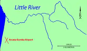 Map of the Little River region | |
| Location | |
| Country | United States |
| State | California |
| Region | Humboldt County |
| Physical characteristics | |
| Source | |
| • coordinates | 40°58′51″N 123°53′41″W[1] |
| Mouth | Pacific Ocean |
• coordinates | 41°01′37″N 124°06′40″W[1] |
• elevation | 0 ft (0 m) |
References
- U.S. Geological Survey Geographic Names Information System: Little River
- http://humboldtgov.org/DocumentCenter/Home/View/1366
- Strand, Rudolph G. Geologic Map of California:Weed Sheet (1963) State of California Resources Agency
- Jarausch, Klaus P.Financing Land Protection in Rural Communities: Assessing the Feasibility of an Open Space District in Humboldt County, California
- http://www.humboldtbaykeeper.org/news/press/911-six-local-humboldt-county-waterways-under-attack-over-600-times-healthy-bacteria-level-detected-in-creek.html