Long Island (Maryland)
Long Island was an island located in Chesapeake Bay, northwest of another former island, Holland Island. The island was shown on maps up until near 1934,[1] when erosion of nearby islands combined with the rising sea levels caused it to be submerged.
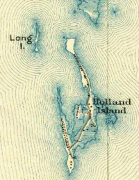 Map of Long Island and Holland Island from a 1927 Topographic Map | |
| Geography | |
|---|---|
| Location | Chesapeake Bay |
| Coordinates | 38°08'11.8"N 76°05'57.6"W |
| Administration | |
United States | |
| State | Maryland |
| Demographics | |
| Population | 0 |
References
- "https://images-na.ssl-images-amazon.com/images/I/A14bPixe1uL._AC_SL1500_.jpg".
|first=missing|last=(help); External link in|title=(help)
This article is issued from Wikipedia. The text is licensed under Creative Commons - Attribution - Sharealike. Additional terms may apply for the media files.